CWAAS Transactions 1897 Article IV
CWAAS Transactions 1897 Article IV is in CWAAS Transactions 1897.
ARTICLE IV. — Shap Stones [Map]. By THE PRESIDENT. Read at Shap Wells, July 15th, 1897.
"Shap Stones" are familiar, by name at least, to all the members of this society, but as a matter of fact, few, if any of us, know anything about them, or are able to point to any trustworthy account of them in print. The words are capable of two meanings, a fact which has produced much confusion and misunderstanding. Sometimes they are held to include all the megalithic monuments in the Shap district, including the stone circles at Gunnerkeld [Map], at Gamelands [Map], and elsewhere; at other times they are restricted to the stones at the actual village or town of Shap. With these I now propose to deal, and will begin by referring to what is already on record about them.


It will further facilitate matters if we state that Shap Stones, in the restricted sense, have been supposed to include, not only an avenue, but also a single row of stones, and one or more circles; and that some, if not all, of the older writers had only seen, or heard of, one or other of these arrangements and not of the whole lot, so that we have one writer describing one part alone as the "Shap Stones," and ignoring all the rest, while another writer describes what the first ignores, and ignores what he describes.
Camden, to whom one naturally turns, says:—
At Shap, formerly Hepe,—a small monastery, built by Thomas, son of Gospatrick, son of Orme,—is a fountain, which, like the Euripus, ebbs and flows several times a day, and several huge stones of pyramidal form, some of them nine feet high and fourteen thick, standing in a row for near a mile at an equal distance, which seems to have been erected in memory of some transaction there which by length of time is lost.1
Note 1. Camden's Brit. edit. Gibson, 1695, p. SoS. Ibid, edit. Gough, 1789, vol. III, p. Oor, and Gough's additions, 414.
Richard Blome gives a similar account. Of these writers (Camden and Blome) my predecessor in the presidential chair of this Society, the late Dr. Simpson, says:-
It is important to observe that the huge pyramidal stones ranged in a row for a mile in length, are not the stones on Karl Lofts, which formed the avenue, but a row of stones on the west side of Shap, connected with the avenue. If Camden or his informant had seen the stones on the south side of Shap, now commonly called Karl Lofts, he must have noticed the peculiarity of their arrangement, which certainly existed long after he wrote. It is, however, not improbable that in Camden's time these stones on Karl Lofts were concealed by brushwood, and scarcely known to exist.f1
Note 1. "The Antiquities of Shap in the County of Westmorland." By Rev. James Simpson, Archæologicol Journal, vol. XVIII, pp. 25-26.
Dr. Stukeley and Roger Gale visited Shap in 1725, but it rained all the time they were there, and rain on a bleak, exposed moor like Shap is singularly inimical to antiquarian persuits.1 But Stukeley published no account of it until 1743, when he issued:
Abury, a Temple of the British, with some others described, 1743.
Shortly before he published it he sent over to Shap an inexperienced surveyor, Mr. Thomas Routh, of Carlisle, to make a survey, and in order to show what he (the doctor) wanted, he provided the surveyor with a plan of Abury, showing the serpentine avenue Stukeley imagined he saw at that place. Routh much pleased Stukeley, for he produced a plan on which Stukeley had no difficulty in finding
a huge serpentine temple like that of Abury.
Note 1. Iter Boreale, p. 42. Fergusson's Rude Stone Monuments, pp. 129, 130, 131.
However Dr. Simpson1, Dr. James Fergusson2, and Mr. Lukis3 all agree in considering Stukeley's ideas on the Shap Stones to be untrustworthy. Mr. Lukis says:-
It is unfortunate that Routh's plan has not been found among the Stukeley papers. In vol. VII of the Doctor's Diary, 3rd September, 1743, the entry is simply—"I received a drawing from Mr. Routh of Carlisle, of the Druid serpentine temple at Shap."4
Note 1. Archæoogical Journal. ut ante.
Note 2. Rude Stone Monuments. ut ante
Note 3. Proceedings, S.A., znd series, vol. X, p. 313, &c. Stukeley's Diaries and Letters, Surtees Society, vol. LXXX, pp. 236-242
Note 4. Proceedings, S.A., 2nd Series, vol. X., p. 3.18.
Dr. Burn in his history of Westmorland published in 1777, says:—
Towards the south end of the village of Shap, near the turnpike on the east side thereof, there is a remarkable monument of antiquity, which is an area upward of half a mile in length, and between twenty and thirty yards broad, encompassed with large stones with which that country abounds, many of them three or four yards in diameter, at 8, io, or 12 yards distance, which are of such immense weight that no carriage now in use could draw them.
Assuming that it had been a Druids' temple, he proceeds to say that
At the high end thereof there is a circle of the like stones about 18 feet in diameter, which was their 'sanctum sanctorum' as it were, and place of sacrifice.1
Note 1. History of Westmorland, vol. i, p. 477.
Dr. Burn lived within five miles of the place, but he took no interest in such remains; the stone circle at Gamelands [Map] is within a mile of his house; he does not even mention it in his history, yet it is one of the most important in England. No wonder, then, that his account of the Shap Stones is inaccurate, and that he made no plan of them. But even so long ago as his day the era of destruction had set in. He says the common people had used several of the stones as foundations of houses, and cut up others into millstones.
None of the writers of these accounts seem to have clearly comprehended what existed at Shap; or to have understood that the "huge stones of pyramidal form" and the avenue were distinct, and that there were also one or two stone circles. Brushwood and bad weather seem to have hindered them, or their informants, from making an exhaustive search, and proper plans: some only saw, or heard of, and recorded one part of the show, and some another part: and some mixed the two or more parts into one. It was reserved for our late president, Dr. Simpson, to indicate, roughly, their position, and the connection between them. He was, at one time, perpetual curate of Shap (though generally known by a higher title) and gathered much information from the ancients of the village, which he put into his paper in the Archæological Journal, referred to before. To that paper you must turn.
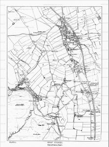
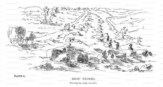
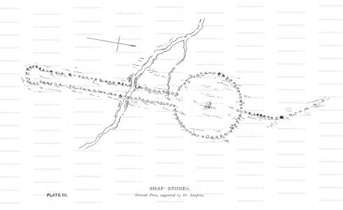
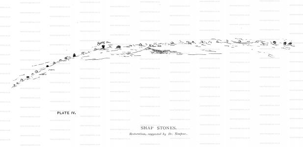
I propose to give you his results, with the aid of a map traced from the Ordnance Survey, (see Plate I). On that map is a farm house, called Brackenbyr, about 100 yards south of the railway station, and nearly opposite the Greyhound Inn, at Shap, which is on the east side of the high road, while the farm is on the west. Here Dr. Simpson thinks he could, in 1859, from tradition and from various indications, make out that there once was a stone circle, 400 feet in diameter, with a large stone in the centre. There is a legend of a huge stone which once stood here, and was cut up into seven pairs of "yat-stoops" (gate posts).1 From this circle at Brackenbyr, an avenue or double row of stones ran to the south and terminated in a stone circle, of which some five stones2, as well as three forming part of the avenue, are still to be seen on the west side of the L. and N. W. Railway, which, most unluckily, on its formation in 1844, passed over and destroyed the remains of the avenue, leaving only the eight stones just mentioned. The diameter of the circle was 30 yards3, and it is at a place called Shapsey, about half a mile to the south of Brackenbyr. With this paper is given, (Plate II) a reproduction of a drawing, made in 1775, by Lady Lowther, wife of Sir James Lowther, afterwards Earl of Lonsdale. This shows the avenue, and is taken from the Shapsey, or south end of it, looking north. Returning again to the Brackenbyr circle, Dr. Simpson makes out a single row of large stones (the huge pyramidal stones) running from that circle in a north-westerly direction, of which four stones remain at Karl Lofts4, about 200 yards north of the Greyhound Inn at Shap. Seven or eight others, including the Guggleby, are yet to be found, and tradition says they extended as far as Moor Divock. Dr. Simpson's restoration of the Shap Stones is reproduced here as Plate III, which gives a ground plan, while Plate IV gives his idea of the appearance presented by the single row of large stones (the huge pyramidal stones) running from the Brackenbyr circle in a north-westerly direction. We are inclined to think he shows far too many stones. Canon Greenwell appears to approve of Dr. Simpson's restoration: at any rate, he writes:—

The large series of standing stones at Shap, however, once consisting of at least a circle and an avenue, is now almost entirely destroyed; but from such parts of it as are left, and from old accounts and the traditional knowledge of the place, the Rev. Dr. Simpson, LL.D., has been enabled to reconstruct it.5
Note 1. The O.S. (six inch scale) shows one stone at Brackenbyr: this would be part of Dr. Simpson's large circle.
Note 2. The five stones, part of the destroyed circle, are shown on the O. S, (six inch scale), and are marked ' Druidical Circle ' in old English letters. The O. S. also shows a single stone at Force Bridge, (close to the east side of the high road, and just south of the water), and three stones about half way between Force Bridge and Brackenbyr; those would from part of the avenue. An isolated stone to the end of the railway is not éonformable.
Note 3. See Dr. Simpson's Paper, ut ante p. 28.
Note 4. Dr. Simpson uses the words 'Karl Lofts' in a two-fold sense, which is rather puzzling. Here he means the four stones north of the Greyhound Inn, at Shap, but in a passage which we have quoted from him at the beginning of this paper, he means the district south to Shap down to Shapsey.
Note 5. British Barrows,: Greenwell and Rolleston, pp. 381-2.


Dr. Fergusson in Rude Stone Monuments, pp. 129-30, in the main agrees with Dr. Simpson, but is unable to trace the Brackenbyr circle. He seems also to have mistaken the direction in which Dr. Simpson considered the single line of stones to have run, and to have imagined Dr. Simpson said south-westerly, whereas he said north-westerly.
Mr. Lukis, in his report to the Society of Antiquaries of London, writes:—
The ground is very undulating, and only a short distance in the direction which the stone rows are said to have taken is visible from any one point. At the present time there are two boulders near the railway stati on, is which do not look as if they had ever been set up; and a third stone, near a barn, j on the west side of the village road, at a considerable distance from them—at such a distance that I cannot imagine how they can have been associated in an avenue, or with each other in any manner. Then in the second grass field, called the Band Keld1, behind the King's Arms Hotel, which is some distance off in Shap Street, there is a large boulder lying on the ground, known as the Druid's Stone, 8 feet g inches long and 7 feet wide, round which the village fife and drum band used to parade, and upon which the drummer stood. A mile away from the first mentioned boulders, in a north-west direction, we come to the only erect monolith (7 feet 9 inches high, from 4 to 5 feet wide at the ground level, and 7 feet 9 inches wide at the top), set up on its smaller end. Upon its north-western face it bears a small circular depression or basin, 5 inches in diameter, artificially made. This is called the Guggleby stone. In the adjoining grass field, following the same corn pass direction, there is a large prostrate, misshapen stone (10 feet long, 5 feet wide), and upon its broad, flat end there is a ring, 8 inches in diameter, enclosing a cup, 2 inches in diameter, and another circular depression or basin, 6 inches in diameter, with a doubtful cup in its centre. Half a mile further, in a grass field, there are two large prostrate boulders, 248 paces apart, one being 13 feet long, 6 feet 6 inches wide, 8 feet 6 inches thick2, the other 10 feet 6 inches in length, and 8 feet wide, and three partially buried boulders in the same field.
Note 1. Called in the Ordnance Survey "Burn Keld." See Plate I. herewith.
Note 2. The "Thunder Stones" of the Ordnance Survey. See Plate I. herewith.


Supposing, therefore, all these stones1 to have belonged to the monument as seen and laid down in a plan by Routh for Stukeley's information, and said to have been miles in length, there exist in 1884 eleven stones, whereof one only is erect, and these stones placed at such wide intervals and in such positions that it is hardly credible how they can have formed part of an avenue, composed of a double row.2
Note 1. The stones, as given by Mr. Lukis, differ in position and number from those shown in the Ordnance Survey. That shows a stone in a line, roughly, between the Band Keld stone and the Guggleby stone; and two more between that stone and the first Thunder stone: it does not show the three partially buried boulders in the same field. See Plate I. herewith.
Note 2. Just so: Dr. Simpson thinks they formed a single row to the north-west of Brackenbyr, while the avenue was to the south of that place. Many people have misapplied Camden's description of the single row to the avenue, which he probably neither saw nor heard of, it being then covered with brushwood.—See these Transactions, vol. II p. xvii.

Pennant, in his North Tour, i, 297, speaks of it as 'a stupendous monument of antiquity, called Karl Lofts,' composed of two lines of huge obelisks of unhewn granite, which commence about 1½ miles south of the town of Shap, and extend in a north-west direction into the demesne of Shap Grange. He says that the remains of it in best preservation are on the common at its south end, where there is a circle of similar stones, 18 feet in diameter, and where the space between the lines is 88 feet; and that the lines gradually converge towards the village of Shap, where the distance decreases to 59 feet; and that it is probable they met and concluded in a point forming a wedge.
There is not a vestige of an avenue and small circle south of Shap at the present time, bnt about three-quarters of a mile in this direction and close to the railway fence, there are six1 prostrate boulders, part of a large circle, which was destroyed when the railway was constructed, and carried through it.
Note 1. Dr. Simpson says five, which have been part of the circle, and three others part of the avenue. The Ordnance Survey marks where the circle was destroyed in the construction of the railway in 1844: the Gent. Mag., 1844, vol. xx N. S. p. 381 gave a view of this circle. Thirteen stones, as it stated, were standing at that time, forming a circle about 40 feet in diameter: the largest stone measuring 8 feet in height. This is not correct, as Dr. Simpson had the original drawing; showing twelve stones, and the diameter was upwards of 30 yards. Archæological Journal, vol. xviii, p. 28 n.
Although Pennant goes into detail in describing the avenue, and therefore induces a belief that a double row of monoliths1 was seen by him, I cannot help thinking that his imagination was influenced by Stukeley's published conjectures respecting Avebury, and this thought is suggested by the words ' it is probable that they (the lines) met and concluded in a point forming a wedge,' which you will remember Stukeley had said was the form of the tail which he invented and tacked on to the Avebury circle in order to complete his serpent.2
Note 1. No doubt: the circle and avenue south of Brackenbyr extending to Shapsey, where was the circle of twelve stones.
Note 2. Proceedings, S. A., ut ante, pp. 317-8.
Mr. Lukis continues —
The evidence, so far, is not strong in favour of a double row, or even of a single row, and as regards the great circle, there is no satisfactory evidence. * * * * My own impression is that it is possible there may have been both a double row and a single row, but not as parts of one system, and that Shap was a necropolis extending over a considerable area.1
Note 1. Ibid. p. 319.
Professor Harkness seems to have considered all the stones of Camden's single line as erratic blocks brought by ice, and declined to believe that their position had anything to do with Druidical arrangements.1
Note 1. These Transactions, vol. II, p. xvii.
To sum up: there can be no doubt about the former existence of the avenue and circle south of Shap: Lady Lonsdale's sketch settles that. The evidence as to the big circle at Brackenbyr is inconclusive. With regard to the line of single stones, the question is, are they erratic ice carried boulders, still where the ice left them, or have they been artificially made into a "single row," after the ice had strewn them about promiscuously: it is probable something was done in that way for the purpose of indicating the road over the moor to Moor Divock, but we cannot believe there were ever as many stones as Dr. Simpson shows on Plate IV.
