Europe, British Isles, North-Central England, Derbyshire, Norbury [Map]
Norbury, Derbyshire is in Derbyshire.
Around 1320 Piers Legh was born at Norbury, Derbyshire [Map].
In 1330 William Fitzherbert was born to William Fizherbert (age 22) at Norbury, Derbyshire [Map].
Around 1365 Henry Fitzherbert was born to William Fitzherbert (age 35) and Alice Longford (age 35) at Norbury, Derbyshire [Map].
In 1400 Nicholas Fitzherbert was born to Henry Fitzherbert (age 35) and Amilia Downes at Norbury, Derbyshire [Map].
Around 1428 Ralph Fitzherbert was born to Nicholas Fitzherbert (age 28) and Alice Booth (age 14) at Norbury, Derbyshire [Map].
Around 1435 Joanna Fitzherbert was born to Nicholas Fitzherbert (age 35) and Alice Booth (age 21) at Norbury, Derbyshire [Map].

Around 1450 Agnes Fitzherbert was born to Ralph Fitzherbert (age 22) and Elizabeth Marshall (age 13) at Norbury, Derbyshire [Map].
Around 1457 Editha Fitzherbert was born to Ralph Fitzherbert (age 29) and Elizabeth Marshall (age 20) at Norbury, Derbyshire [Map].
In 1464 Henry Fitzherbert was born to Ralph Fitzherbert (age 36) and Elizabeth Marshall (age 27) at Norbury, Derbyshire [Map].
Around 1466 Anthony Fitzherbert was born to Ralph Fitzherbert (age 38) and Elizabeth Marshall (age 29) at Norbury, Derbyshire [Map].
Around 1468 Dorothy Fitzherbert was born to Ralph Fitzherbert (age 40) and Elizabeth Marshall (age 31) at Norbury, Derbyshire [Map].
In 1470 Richard Fitzherbert was born to Ralph Fitzherbert (age 42) and Elizabeth Marshall (age 33) at Norbury, Derbyshire [Map].
In 1472 Thomas Fitzherbert was born to Ralph Fitzherbert (age 44) and Elizabeth Marshall (age 35) at Norbury, Derbyshire [Map].
In 1474 Margaret Fitzherbert was born to Ralph Fitzherbert (age 46) and Elizabeth Marshall (age 37) at Norbury, Derbyshire [Map].
In 1474 William Fitzherbert was born to Ralph Fitzherbert (age 46) and Elizabeth Marshall (age 37) at Norbury, Derbyshire [Map].
Around Sep 1480 Elizabeth Fitzherbert was born to John Fitzherbert (age 18) and Benedicta Bradbourne (age 20) at Norbury, Derbyshire [Map].
In 1483 Alice Fitzherbert was born to Ralph Fitzherbert (age 55) and Elizabeth Marshall (age 46) at Norbury, Derbyshire [Map].
On 02 Mar 1484 Ralph Fitzherbert (age 56) died at Norbury, Derbyshire [Map]. He was buried at Church of St Barlok, Norbury [Map].
On 20 Oct 1490 Elizabeth Marshall (age 53) died. She was buried at Church of St Barlok, Norbury [Map].
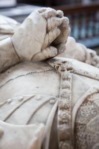
Monument to Ralph and Elizabeth. Finely made in Chellaston alabaster of the Fluted Period. Possibly Harpur and Moorecock of Burton on Trent.
Ralph Fitzherbert: Ralph Fitzherbert and Elizabeth Marshall were married. Around 1428 he was born to Nicholas Fitzherbert and Alice Booth at Norbury, Derbyshire.
Elizabeth Marshall: Around 1437 she was born to John Marshall.
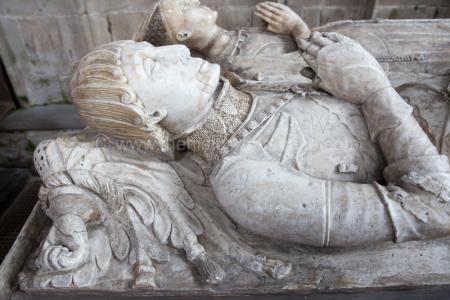 Bobbed hair with finely detailed ringlets. No facial hair. Suns and Roses Collar and the Fitzherbert Clenched Fist Crest.
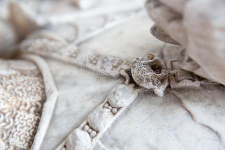 His effigy notable for being the only remaining with the Yorkist Boar Pendant (boar of Richard III) on his Suns and Roses Collar.
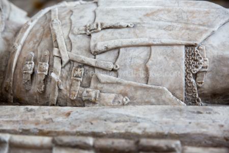
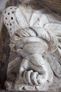
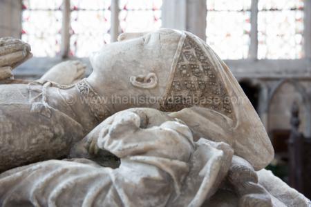 A finely carved Horned Headdress.
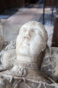 A finely carved collar with Mary and baby Jesus pendant.
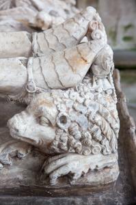
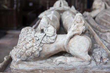 Fine Sabatons, the armoured feet, with spurs. Note the Bedesman, looking somewhat bored, under the right foot. Unlikely the sculptor had ever seen a lion. Feet resting on a Lion with Swirling Tail and Chunky Lions Mane.
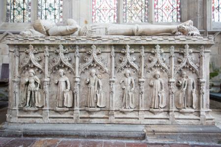 The chest finely made with weepers on the three extant sides. On one side five single men (a knight, a monk, two merchants and one unknown), and one couple. On the other side women, four single, two duos. Ralph and Elizabeth had twelve children, six male, six female so probable the weepers represent their children, possibly with spouses, possibly with offspring since in the two females duos there is a noticeable difference in height.
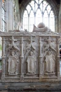
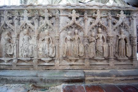 Excellent weepers on all sides, probably their issue, possibly with grandchildren, on the longer sides since they had six boys and six girls. Chest with Weepers holding Shields.
Around 1515 Elizabeth Fitzherbert was born to Anthony Fitzherbert (age 49) and Maud aka Matilda Cotton (age 27) at Norbury, Derbyshire [Map].
In 1521 Lawrence Hyde was born at Norbury, Derbyshire [Map].
On 27 May 1538 Anthony Fitzherbert (age 72) died at Norbury, Derbyshire [Map].
The River Dove rises on Axe Edge Moor [Map] after which it travels broadly south past Longnor, Saffordshire [Map], Pilsbury [Map], Hartington [Map], Milldale, Derbyshire [Map], Thorpe, Derbyshire [Map], just before whic it is joined by the River Manifold, Mapleton, Derbyshire [Map], Mayfield, Staffordshire [Map], Norbury, Derbyshire [Map], Rocester, Staffordshire [Map], Sudbury Hall [Map] and Tutbury Castle, Staffordshire [Map] before joining the River Trent at Newton Solney [Map].
Europe, British Isles, North-Central England, Derbyshire, Norbury, Over Haddon [Map]
In 1370 Sir Godfrey Foljambe (age 26) the younger (son of the eminent lawyer and retainer of John of Gaunt (age 29)) confirmed him in possession of part of the manors of Over Haddon [Map], Rowsley [Map], Wardlow [Map], Monyash [Map] and Chelmorton [Map] in Derbyshire, which were to Gaunt (age 29) himself.
Europe, British Isles, North-Central England, Derbyshire, Norbury, Parsley Hay [Map]
After Buxton The Street continues south following the A515 past [Map], Pomeroy [Map], Parsley Hay [Map] where it turns towards Oldham Farm Barrow [Map] and Pikehall [Map] after which it passes Minning Low Chambered Tomb [Map] turning before Brassington [Map] onto Manystones Lane [Map] continuing east into Wirksworth [Map].
Europe, British Isles, North-Central England, Derbyshire, Norbury, Pikehall [Map]
After Buxton The Street continues south following the A515 past [Map], Pomeroy [Map], Parsley Hay [Map] where it turns towards Oldham Farm Barrow [Map] and Pikehall [Map] after which it passes Minning Low Chambered Tomb [Map] turning before Brassington [Map] onto Manystones Lane [Map] continuing east into Wirksworth [Map].
Europe, British Isles, North-Central England, Derbyshire, Norbury, Pilsbury [Map]
Pilsbury [Map] is a Norman motte-and-bailey castle occupying an area of high ground around 160m by 137m overlooking the River Dove commissioned by Henry Ferrers.
The River Dove rises on Axe Edge Moor [Map] after which it travels broadly south past Longnor, Saffordshire [Map], Pilsbury [Map], Hartington [Map], Milldale, Derbyshire [Map], Thorpe, Derbyshire [Map], just before whic it is joined by the River Manifold, Mapleton, Derbyshire [Map], Mayfield, Staffordshire [Map], Norbury, Derbyshire [Map], Rocester, Staffordshire [Map], Sudbury Hall [Map] and Tutbury Castle, Staffordshire [Map] before joining the River Trent at Newton Solney [Map].
Europe, British Isles, North-Central England, Derbyshire, Norbury, Pomeroy [Map]
After Buxton The Street continues south following the A515 past [Map], Pomeroy [Map], Parsley Hay [Map] where it turns towards Oldham Farm Barrow [Map] and Pikehall [Map] after which it passes Minning Low Chambered Tomb [Map] turning before Brassington [Map] onto Manystones Lane [Map] continuing east into Wirksworth [Map].
Europe, British Isles, North-Central England, Derbyshire, Norbury, Rowsley [Map]
In 1370 Sir Godfrey Foljambe (age 26) the younger (son of the eminent lawyer and retainer of John of Gaunt (age 29)) confirmed him in possession of part of the manors of Over Haddon [Map], Rowsley [Map], Wardlow [Map], Monyash [Map] and Chelmorton [Map] in Derbyshire, which were to Gaunt (age 29) himself.
On or before 08 Nov 1821, the date he was baptised, Thomas Bateman was born to William Bateman (age 34) in Rowsley [Map].
The River Derwent rises on Bleaklow [Map] after which it passes Bamford [Map], Hope, Derbyshire [Map], Hathersage [Map], Grindleford [Map], Baslow, Derbyshire [Map], Chatsworth House [Map] passing under Chatsworth Bridge [Map], Rowsley [Map] which it is joined by the Derbyshire River Wye, Matlock [Map], Matlock Bath [Map], Cromford [Map], Ambergate [Map] where it is joined by the River Amber. After Ambergate [Map] it passes Belper, Derbyshire [Map], Duffield, Derbyshire [Map] then flows through the centre of Derby [Map] after which it joins the River Trent around 1.4 Km east of [Map].
The Derbyshire River Wye rises at Axe Edge Moor [Map] after which it travels broadly south-west through Buxton, Derbyshire [Map], Millers Dale [Map], Cressbrook, Derbyshire [Map], Ashford-in-the-Water, Derbyshire [Map], Bakewell, Derbyshire [Map] and Haddon Hall [Map] to Rowsley [Map] where it joins the River Derwent.
Europe, British Isles, North-Central England, Derbyshire, Norbury, Sheldon [Map]
Europe, British Isles, North-Central England, Derbyshire, Norbury, Sheldon, Manor House Barrow [Map]
Manor House Barrow, Sheldon is also in Peak District Bronze Age Barrows.
Thomas Bateman 1845. About half a mile from the village of Sheldon are two large barrows, placed about three hundred yards distance from each other, both of which were opened on the 6th of May, 1845. On cutting into the first tumulus [Map], which was the one nearest the village, it was found to have been previously examined, no undisturbed deposit or interment having been met with. The following articles were found promiscuously mingled with the earth and stones in the interior of the tumulus: fragments of two urns, a few burnt bones and charcoal, a skeleton pretty nearly complete, a few bones of a young person, bones of rats, polecats, and other animals, and chippings of a coarse kind of flint, none of which were of any marked or characteristic shape.
Europe, British Isles, North-Central England, Derbyshire, Norbury, Sheldon Barrow [Map]
Sheldon Barrow is also in Peak District Bronze Age Barrows.
Thomas Bateman 1845. The second barrow [Map], which was much lower than the former, was untouched by any previous seekers of antiquities; yet having cleared the superincumbent strata from the floor of the barrow, nothing was discovered to repay the labour, until, on a close examination of the rock which appeared above the surface of the ground a circular excavation was perceived about the centre of the barrow which contained a large urn the upper part of which is ornamented, inverted over a deposit of burnt human bones, which, when viewed through a hole in the urn, presented a pleasing sight, being quite free from soil, and beautifully variegated with tints of blue and purple, from the action of heat. The urn is about thirteen inches in diameter, and fitted exactly the excavation made to receive it. In this barrow, as in the preceding, large quantities of rats' bones and chippings of coarse flint or chert were found.
Europe, British Isles, North-Central England, Derbyshire, Norbury, Shirley [Map]
Around 1351 Hugh Shirley was born at Shirley [Map].
In 1413 Ralph Shirley was born at Shirley [Map].
On 24 Jul 1828 Walter Waddington Shirley was born to Bishop Walter Augustus Shirley (age 31) at Shirley [Map].
Europe, British Isles, North-Central England, Derbyshire, Norbury, Snelston [Map]
In 1525 Nicholas Browne was born at Snelston [Map].
On 18 Jan 1587 Nicholas Browne (age 62) died at Snelston [Map].
Europe, British Isles, North-Central England, Derbyshire, Norbury, Stanton [Map]
On or before 16 May 1819 Ann Goodwin was born to Thomas Goodwin and Ann Hollis at Stanton [Map]. She was baptised on 16 May 1819. Her mother's name was Anne. Her father's profession was Miner.
Europe, British Isles, North-Central England, Derbyshire, Norbury, Sudbury [Map]
On 01 Aug 1827 Alice Lucy Whitefoord Baroness Vernon (age 60) died at Sudbury [Map].
On 27 Mar 1829 Henry Venables-Vernon 3rd Baron Vernon (age 81) died at Sudbury [Map]. His son George Charles Venables-Vernon 4th Baron Vernon (age 49) succeeded 4th Baron Vernon of Kinderton in Cheshire. Frances Maria Warren Baroness Vernon (age 44) by marriage Baroness Vernon of Kinderton in Cheshire.
Europe, British Isles, North-Central England, Derbyshire, Norbury, Thor's Cave [Map]
Thomas Bateman 1846. On the 18th of July, 1846, two barrows in the neighbourhood of Wetton, Staffordshire, were opened, which, although not containing any objects of British manufacture, save rude flint instruments, and being even destitute of human remains, still present a new and unaccountable feature in the annals of barrow-digging, the uniformity of which in two instances entirely precludes the opinion of the deposits being accidental. The first opened was a small circular barrow situated near "Thorns Cave [Map]," in Wettondale (a wonderful example of nature's architecture). The mound was raised upon the surface of the rock, by heaping up a collection of stones, amongst which were many boldered ones, apparently brought up from the neighbouring watercourse; there was a small excavation in what is technically called a soft joint in the rock, which contained a single jaw-bone of an ox, or cow, close to which lay a piece of flint; this was the only trace of animal remains in the barrow.
The River Manifold rises on Axe Edge Moor [Map] after which it travels broadly south past Longnor, Saffordshire [Map], Hulme End [Map], Ecton, Staffordshire [Map], Thor's Cave [Map], Beeston Tor, Staffordshire [Map] and Ilam, Staffordshire [Map] at which it joins the River Dove.
Europe, British Isles, North-Central England, Derbyshire, Norbury, Thorpe [Map]
The River Dove rises on Axe Edge Moor [Map] after which it travels broadly south past Longnor, Saffordshire [Map], Pilsbury [Map], Hartington [Map], Milldale, Derbyshire [Map], Thorpe, Derbyshire [Map], just before whic it is joined by the River Manifold, Mapleton, Derbyshire [Map], Mayfield, Staffordshire [Map], Norbury, Derbyshire [Map], Rocester, Staffordshire [Map], Sudbury Hall [Map] and Tutbury Castle, Staffordshire [Map] before joining the River Trent at Newton Solney [Map].
Europe, British Isles, North-Central England, Derbyshire, Norbury, Thorpe, Broadlowash [Map]
Broadlowash, Derbyshire is also in Peak District Bronze Age Barrows.
Samuel Carrington 1851. On the 1st of March we resumed our labours for the season, having obtained permission to excavate two barrows near Broad Low Ash [Map], in a field to the right hand of the road leading from thence to Ashbourne, from which town they are about two miles distant. They are not more than ten yards asunder, and their diameters are respectively seventeen and twenty-two yards. We selected the least for examination first, and found it to consbt of stiff earth, with many large stones in the centre. On sinking down at this point, we found human bones that had been displaced to make room for a later interment; beneath was a grave cut one foot deep in the uatural soil, which was about a yard from the summit of the mound. The first undisturbed interment lay on the natural level, close to the north-east side of the grave. It was a skeleton reposing on its right side, with the head to the north, having with it a small spear-head of flint, and near the skuU a deposit of calcined human bones, containing two neatly chipped flints, both fractured from having been burnt with the body. We have here a double interment, by inhumation and cremation, suggesting a barbarous rite. Within the grave was the skeleton of a young person, lying on the right side, in the same direction as the others. Before the face was a very neatly ornamented vessel of clay, 5½ inches high, inverted upon the smooth side of a large boulder; and a small spear-head of flint. The ornamentation of the vase has been effected in part by a flat-sided pointed instrament, and partly by the thumb nail.
Samuel Carrington 1851. On the 8th of March we examined the largest barrow at Broad Low Ash [Map], which is so near the road as to have lost a part of one side by the fence, although the centre remained perfectly intact. By digging a trench, nine feet wide and eighteen feet long, through the middle, we found it to be entirely composed of earth, except in a place about two yards from the roadside, where there were a number of stones about a foot beneath the surface, and near them some charcoal, with burnt bones in small quantity, and flakes of flint. No other trace of interment was found.
In other barrows similarly composed of earth, flat stones and scattered bones have been found near the summit, all below being formed of solid earth, frequently in strata of different colour, which have evidently never been disturbed, whilst the most careful search has failed to discover any deposit in the usual situation on or below the natural soil; whence we may conclude that in this by no means unfrequent class of tumuli, the interment (generally by cremation) was for some reason placed near the surface, where it was so liable to destruction by cultivation and other causes so as to render it a matter of surprise that any remnants should have been preserved to the present day.
Europe, British Isles, North-Central England, Derbyshire, Norbury, Thorpe, Lid Low Barrow [Map]
Lid Low Barrow is also in Peak District Bronze Age Barrows.
Ten Years' Digging Appendix. Barrow Near Warslow, Opened By Mr. Herbert Manclarke.
On the 18th of April, 1850, a barrow at Brownlow [Brown Low Barrows [Map]], near Warslow, was opened in the presence of numerous spectators, by Mr. Manclarke. It consisted mostly of earth, and was examined by digging a pit down the middle to the depth of five feet, when the undisturbed soil appeared strewed with charcoal, mixed with burnt bones, from among which were taken two pieces of flint, wherewith the discovery terminated.
On the 27th of November, 1851, a barrow near Warslow, called Lid-Low [Lid Low Barrow [Map]], was opened by Sir John Harpur Crewe, Bart., and Sir Gardner Wilkinson, in which they found a skeleton, accompanied by a fine bronze dagger, 7½ inches long, with two rivets attached to it, and two others separate, all lying near the head, besides two well-formed spear-heads of flint, the largest of which measures 2¾ inches in length.
Europe, British Isles, North-Central England, Derbyshire, Norbury, Tideswell [Map]
Around 1344 Godfrey Foljambe "The Younger" was born to Godfrey Foljambe (age 27) at Tideswell [Map].
In 1410 Thomas Foljambe was born to Thomas Foljambe (age 50) and Margaret Loudham at Tideswell [Map].
In 1433 Thomas Foljambe (age 73) died at Tideswell [Map].
In 1462 Sampson Meverell (age 73) died at Tideswell [Map].
In 1503 Henry Foljambe (age 70) died at Tideswell [Map]. He was buried at Chesterfield [Map].
Archaeologia Volume 29 Section XIII. The preceding dates are taken from the testing clauses of the King's writs, with some slight assistance from Wardrobe accountsc. From the same authentic sources we learn that he then remained but two days at Clipston, leaving it on the morning of the 23rd, on which day there are writs tested at Dronfield [Map], a village between Chesterfield and Sheffield. On the 24th and 25th he was at Tidswell [Map], and on the 26th at Chapel-en-le-Frith [Map]. On the 27th he was at Macclesfield [Map]. He remained there till the 6th of October. On the 7th he set out on his return to Clipston, passing through Ashford, Chesterfield, and Langwith. That in this excursion he was enjoying the diversion of the chace appears from an entry in the Wardrobe accounts of the payment of 6s. 8d. of the King's gift to Robert at Hall of Wyrardeston, "quia navigavit in aqua post cervum in quoddam stagnum in foresta de Pecco [because he sailed in the water after a deer into a certain pond in the forest of Peccus]."
Note c. A complete Itinerary of this reign was made for the late Record Commission, to which I am indebted for these dates.
Europe, British Isles, North-Central England, Derbyshire, Norbury, Tissington
Europe, British Isles, North-Central England, Derbyshire, Norbury, Tissington, Bassett Wood Barrow [Map]
Bassett Wood Barrow is also in Peak District Bronze Age Barrows.
Thomas Bateman 1845. The afternoon of the same day was occupied in opening a much larger barrow [Map] [Bassett Wood Barrow [Map]] at Basset Wood, near Tissington, which (though seldom found to be the case in this county) was entirely formed of earth, and was as compact as though it had been a mound formed by nature, instead of a tumulus raised by the hands of the early inhabitants of these parts; owing to this appearance of the soil, attributable doubtless to the high antiquity of the structure, it was for some time considered doubtful whether it had ever been before disturbed, until the discovery of a regular floor of large limestones neatly jointed, set the question at rest. This floor was found to have been placed upon the level of the natural soil, to have been strewed with charcoal, and then to have been covered to a depth of six feet with the sepulchral mound, in the centre of which it was entombed. No remains being apparent upon the upper side of the floor, it was removed, and was found to cover a small round cist, about a foot in diameter, of the most primitive description, being nothing more than an excavation in the earth; it contained burnt bones, the remains of one person, and a good deal of charcoal. There were a few traces of animal remains a few inches above the limestone floor, but of such an indefinite nature, that it would have puzzled even Cuvier to have made anything intelligible of them, being no more than a lights coloured earth, amongst which the cellular structure of the interior of bones was apparent.
Europe, British Isles, North-Central England, Derbyshire, Norbury, Tissington, Crake Low Barrow [Map]
Crake Low Barrow is also in Peak District Bronze Age Barrows.
Crake Low. On the 6th of July the remainder of a mutilated barrow near Tissington, called Crake Low [Map], were explored, attention having been directed towards it by human bones being dug up by persons destroying the mound for the sake of the limestone to be found in it. Upon making a section across the presumed centre of the barrow, which had long sinqe been levelled with the ground, we met with two interments which had escaped the general ruin; but which, owing to their nearness to the surface, were in an advanced state of decay. They consisted of the skeleton of a young person, accompanied by two calcined flints; and a deposit of burnt human bones, with one burnt flint, both placed within a rough cist formed of limestones set on edge; between the two was a small vase of coarse clay, 5½ inches high, perfectly devoid of ornament.
A further discovery of two skeletons and a very small plain rase, which was placed at the head of one of them, was made by some labourers opening a stone quarry near the edge of the mound in December, 1850. The vase and part of the skulls are preserved at Lomberdale House [Map].
Sheen. On the 15th of July we made an excavation, four yards long by three wide, in a barrow in the garden at Newton Grange, near Tissington, Derbyshire. The mound measured fifteen yards diameter and four feet high, and is composed of stiff earth, mixed with chert, amongst which we observed charcoal and a few chippings of flint at intervals from the surface to the natural level, where there were some pieces of calcined bone, a piece of coal, and an iron nail, the two last shovring that the barrow had been previously opened. On the same day we dug a hole in the middle of another barrow [Crake Low Barrow [Map]?], on a hill at Newton Grrange, looking towards Parwich, the dimensions of which were twenty-eight yards diameter by two feet six inches in height, finding it composed of earth and gravel, but making no discovery.
On the 18 th October we turned over a space of about twelve square yards in the centre, for the most of which we found the natural level strewed with charcoal and burnt earth, where were also a few rude flints, but no trace of interment. We likewise tried other parts of the barrow without success.
Europe, British Isles, North-Central England, Derbyshire, Norbury, Tissington, Hollington Barn Barrow [Map]
Hollington Barn Barrow is also in Peak District Bronze Age Barrows.
Thomas Bateman 1845. On the 26th of June, 1845 was opened a small barrow [Map] [Hollington Barn Barrow [Map]] situate upon Hollington pasture near Tissington. Its appearance was deceptive, owing to its being raised upon a natural elevation, and gave every indication on the outside of having been never disturbed, but, on removing the turf, it became apparent that most of the artificial part of the mound had been removed, and that the natural soil came to within a few inches of the surface; this being the case, it was evident that very little could be expected; indeed nothing was found more than a few pieces of human bones, one small bit of an urn, and various chippings of flint, sufficient, however, to prove the original funereal intention of the structure.
Europe, British Isles, North-Central England, Derbyshire, Norbury, Tissington, Lid Low Barrow [Map]
Lid Low Barrow is also in Peak District Bronze Age Barrows.
Thomas Bateman 1845. On the 23d of December, 1845, a barrow, in the neighbourhood of Thorpe (called Lid Lowe [Map],) was opened by Mr. Price, of that village; it had been disturbed in the previous summer by some of the neighbouring villagers, who found three human skeletons, one of them of a female; all which they destroyed, with the exception of the jaws and teeth, which were distributed as great curiosities. The result of Mr. Price's labours was the discovery of the skeleton of a man, accompanied by the bones of a dog, and a small urn, of the usual coarse material, about four inches in diameter at the mouth. It would seem that this was the principal and earliest interment in the tumulus, as the skeleton and urn were inclosed in a cist formed of three upright stones, exactly in the centre of the barrow; the space within the cist was not more than three feet each way, consequently the body at the time of interment must have been placed in a sitting or contracted position. As is usual in the Derbyshire barrows, the bones of the deceased were mingled with those of the rat, and a few casual remains, unconnected with the preceding, were found in the progress of excavation; namely, a few teeth of a young person, one of an adult, and a horse's tooth. The tumulus appears to be of the form of the long barrows, described by Sir Richard Hoare as being generally unproductive of relics of any interest; its dimensions being twenty-four feet wide and thirty-six in length; in this respect it differs from the great proportion of the Derbyshire barrows, almost all of which are of the circular or bowl-shaped form.
Europe, British Isles, North-Central England, Derbyshire, Norbury, Tissington, Newton Grange Barrow [Map]
Newton Grange Barrow is also in Peak District Bronze Age Barrows.
Thomas Bateman 1845. On the 5th of July, 1845, a large barrow [Map] [Newton Grange Barrow [Map]], about nine feet in height and forty yards in diameter, was examined; it is situated in a field called Gorsey Close, at Newton Grange, near Tissington, and is a conspicuous object on the left hand side of the road from Buxton to Ashbourne. The tumulus was found to consist of a mass of solid earthy without any admixture of stones and in this respect it closely resembled one opened at Bassett Wood [Map] on the 26th of June. The excavation was continued without success until the surface of the natural soil appeared nothing being discovered, save a few bits of oxydized iron of indefinite form, which were picked up about a yard below the surface of the tumulus. Notwithstanding this discouraging termination to the day's labour, the curious and entirely novel manner in which the barrow was constructed repaid the trouble of opening it. To the height of about four feet from the bottom the soil was interspersed with alternate layers of moss and grass, both of which in a great measure retained their original colour and texture; the number of these alternations was twelve, and upon the lowest one, which was upon the undisturbed surface of the ground, were many pieces of wood, hazlesticks still retaining their glossy bark, fungi, and "mirabile dictu" beetles, whose elytræ still shone with the metallic lustre usual to these insects. The proofs of ancient occupation were also found upon this level; these were several rude instruments of flint, one small piece of a coarse urn, and several pieces of charcoal; the imperishability of which was, in this case, rivalled by substances of the most fragile and evanescent nature.
Europe, British Isles, North-Central England, Derbyshire, Norbury, Tissington, Sharp Low Barrow [Map]
Sharp Low Barrow is also in Peak District Bronze Age Barrows.
Sharp Lowe. On the 27th of March, was opened a low flat barrow, called Sharp Low [Map], situated on the summit of a hill to the left of the road to Dovedale, from the New Inns toll-bar. In no part did the elevation exceed 18 inches. In the first place, an excavation was made from the south side to the centre; it was then continued at right angles to the west; in each of these cuttings was found a skeleton; and in the middle of the barrow was a stone, beneath which lay the horn of a bull, accompanied by another bone. The body in the south trench, first discovered, was apparently that of a young person, and was laid upon its right side in a contracted position, without the least protection or accompaniment by cist or weapon. The other in the western cutting was equally unprotected, but was accompanied by an iron knife of the usual form, which lay at the left side of the skeleton, which, from the impression retained by the rust on the knife, must have been swathed in fine woollen cloth. It is worthy of remark that this body, although evidently interred at a comparatively late epoch, was laid on the left side in the contracted posture so uniformly observed by the earlier Celtic population. In illustration of this remark, it may be stated, that we do not remember having previously met with an instance of an interment of the iron period, otherwise than at full length; nor, on the other hand, have we seen any skeleton accompanied by relics of the earlier ages, fully extended. In the vicinity of the latter skeleton were a few animal bones, and two pieces of well baked earthenware; but the usual layer of rats' bones was absent.
Europe, British Isles, North-Central England, Derbyshire, Norbury, Tissington, St Mary's Church [Map]
On 30 Jul 1791 William Fitzherbert 1st Baronet (age 43) died. He was buried at St Mary's Church, Tissington [Map]. His son Anthony Perrin FitzHerbert 2nd Baronet (age 12) succeeded 2nd Baronet Fitzherbert of Tissington in Derbyshire.
Europe, British Isles, North-Central England, Derbyshire, Norbury, Wardlow [Map]
In 1370 Sir Godfrey Foljambe (age 26) the younger (son of the eminent lawyer and retainer of John of Gaunt (age 29)) confirmed him in possession of part of the manors of Over Haddon [Map], Rowsley [Map], Wardlow [Map], Monyash [Map] and Chelmorton [Map] in Derbyshire, which were to Gaunt (age 29) himself.
Europe, British Isles, North-Central England, Derbyshire, Norbury, Wardlow, Rolley Low Barrow [Map]
Rolley Low Barrow is also in Peak District Bronze Age Barrows.
Section I Tumuli 1844. On the 6th of August 1844 was opened a most interesting barrow upon Wardlow Common which is known by the name of Rolley Lowe [Map]; it is a mound of considerable magnitude, being forty-five feet in diameter, and five feet in height at the centre. As the discoveries made in this barrow are of a very miscellaneous character, and of various dates, it will be the most simple course to record them in the order in which they occurred: in the course of the central excavation, in which all the relics were found, about a foot from the surface, and dispersed amongst the soil which was found to be unmingled with stones to the depth of eighteen inches, were found a few human bones and teeth, and a third brass coin of Constantino the Great; near the bottom of this upper stratum of soil, where it began to be slightly mixed with stones, a brass pin, two inches and three quarters in length, square at the thicker end for insertion into a handle, was found. About three feet from the surface of the mound, a central area about eight feet in diameter was discovered, which seemed to be walled out in a circular form, and divided into five partitions by large limestones, so as to exhibit a ground plan similar to a roulette-table. There was no appearance of any of these vaults having been protected by coverings; when discovered, each was filled with small stones, amongst which lay the skeletons, which occupied all these partitions, whilst in one was also an urn. But to resume the particulars in the order before stated; in the first examined recess was a human skeleton, minus the head but complete in other respects; with this interment was deposited the under jaw of a child; in the next compartment was a skeleton without any accompaniment: in the following cist was a large and coarse urn, inverted over a deposit of calcined human bones, amongst which was a large red deer's horn, also calcined; the urn was about sixteen inches in height, and twelve in diameter; and, owing to its size and fragile texture, was broken to pieces in the attempt made to remove it; near the urn was a skeleton with a fine and well-preserved skull. In the last examined division, which was the northern-most, lay a human skeleton, with which were deposited a large horn from the red deer, and the jaw of an otter. Proceeding down about a foot lower than the level upon which all these skeletons were laid, another skeleton was found laid upon a large stone, on the level of the natural soil; it was accompanied by three rude instruments of flint, and the head lay directly beneath the large urn before mentioned: the stone in question measured in length six feet, and in breadth about four feet, being upon the surface of the ground it was at first thought to be rock but a piece being broken off, disclosed to view a sight such as is seldom witnessed by the barrow-digger, and which repays him for his frequent disappointments; this was a cist or vault, three feet in length, two feet in width, and eighteen inches in depth, formed of four smooth limestone slabs, having a fifth as a pavement, all the angles and joints having been so effectually secured by a pointing of tenacious clay, that not a particle of soil had entered this primitive coffin, the workmanship of which was in every respect neat and accurate. It was tenanted by a skeleton with contracted knees, whose bones, though much decayed, lay in the posture they had assumed on the decomposition of their fleshy covering; in the rear of the skeleton, was laid on one side a highly ornamented urn, of rude but chaste design, and in various situations in the cist were found two very neat arrow-heads of flint, of uncommon form, a large tusk of the wild boar, seven inches in length, and a piece of tempered clay, to which adhered some fragments of decayed wood. The excavation for the vault was made in the natural soil, and from the floor of the cist to the summit of the tumulus was at least six feet six inches. The undermentioned articles, which did not appear to be connected with any of the interments, were found in various situations, throughout the interior of the barrow; namely, a fragment of an ornamented drinking-cup, a spear-head of coarse flint, and similar workmanship, a few animal teeth, and rats' bones "ad infinitum." The outer circumference of the major part of this barrow was constructed of some description of clayey composition, which had become as hard as a turnpike road.
Europe, British Isles, North-Central England, Derbyshire, Norbury, Wardlow Barrow 1 [Map]
Wardlow Barrow 1 is also in Peak District Bronze Age Barrows.
Section I Tumuli 1759. Near Wardlow, a barrow [Map] [Wardlow Barrow 1 [Map]] was examined, in the year 1759, by the Rev. Mr. Evat, of Ashford. There were discovered in it about seventeen human bodies. These appeared to have been laid upon the surface of the ground, on long flat stones. They were inclosed by two side-walls, and the head and breast of each were protected from the incumbent weight of stone by a flat one laid over that part of the top. Two bodies near the middle of the barrow were walled up, and covered from head to foot, in the form of a long chest, with a stone cover to each. Jaw-bones, teeth, &c., were found undecayed, but none of the larger bones of the bodies. The barrow was thirty-two yards in diameter, and five feet high; the coffins or cells were two feet deep, and the complete ones were seven feet six inches long.
Wardlow Barrow 1 Account. Full title: XC. An Account of a remarkable Monument found near Ashford in Derbyshire: In a Letter from the Reverend Mr. Evatt, of Afhford, to Mr . Whitehurft, of Derby. Communicated by Benjamin Franklin, LL.D. F. R. S.
Dear Sir, Ashford, October 5, 1761.
Read 13 May 1761.
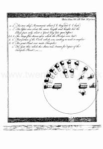
The following is the best account I am able to give you of the curiosity I told you of, discovered some time ago in our neighbourhood; to which I have added, an imperfect drawing, that, I hope, Will, notwithstanding, give you a tolerable idea of it.
In the year 1759, as fome people were making a turnpike-road through the village of Wardlow, near this place, they thought proper to take out of an adjoining field, a heap of ftone, that had lain there time immemorial, and without any tradition, that I could find, why it was thrown together in that place, although it was manifeft it was a work of art. Here, to their great furprize, upoh removing the ftone, they found a monument [Map], to the memory of feventeen perfons, or more, who had been there interred, in the manner exprdled in the drawing annexed. [Vide Tab. XV.]
The bodies appeared to have been laid upon the furface of the ground, upon long flat ftones, and their heads and breafts protected from the incumbent weight of ftone, by fmall walls made round them, with a flat ftone over the top, as I have endeavoured to exprefs in the figures, excepting the two capital ones, marked a, a, which were walled up, and covered from head to foot, in the form of a long chest, with a stone cover over each.
Upon removing the rubbish, many bones, such as jaw-bones, teeth, and the like, were found undecayed; but none at all of the larger bones of the body, that I could learn. The heap of stones, that covered them, was 32 yards in diameter, and about five feet high; and the stones, of which the coffins, or tombs, were composed, appear, very plainly, to have been taken from a stone quarry, above a quarter of a mile distant. In the drawing, you see a part of the circle is vacant; but it is probable it was not so, as there were found several bones and teeth in that space; the cause might be, that as part lay next the road, it might have met with an accidental difturbance; or, what is yet more likely, the people that came to lead the stone away, beginning on that side of it, destroyed that part, before they were aware that it was any-ways remarkable, or worthy note.
There is one circumstance, that seems to denote the monument to have been rather modern; which is this. It appears, from the best observations I could make, that the wall, marked 4 , was erected before the monument was made, as I think it hardly probable, that the persons, who built it, would be at the trouble to remove that part of the circle, that was without, for the fake of building a field-wall, entirely level; which is the cafe, for all that portion of the circle, from the infide of the wall, was as level as any other part of the field: and as walls, I apprehend, are not of very antient date here, (if the above be a fact) I cannot help concluding, that the monument mull have been erected in fome or other of the wars of the houfes of York and Lancafter, or later. But this is only conjecture, and muft be fubmitted to the judgment of the more curious, or thofe who may have heard of, or feen, fome fimilar ones; for my part, in my reading, I have not met with any thing at all like it. The feveral coffins were about two feet high each; the two complete ones about 7.6 long each; and the others had the fiat ftone nearly the lame length; but the covering extended only as far as the breaft.
hefe are all the particulars I am now able to give you, of this remarkable monument. It is now totally deftroyed. If any of your friends, to whom you may, poffibly, communicate this, could afcertain, in any meafure, the date of it, Ihould be extremely glad to hear it from you, as, I think, it would greatly affill me in tracing fome other remarkable curiolities in our neighbourhood, by way of preparation for a natural hiftory of this part of our county.
I am.
Dear Sir,
Your sincere friend,
and humble servant,
Samuel Evatt.
XCI. Dejcriptia
Stephen Glover 1831. Near to Wardlow a barrow [Wardlow Barrow 1 [Map]] was examined in the year 1759 by the Rev Mr Evat of Ashford. There were discovered in it about seventeen human bodies. These appeared to have been laid on the surface of the ground upon long flat stones They were enclosed by two side walls and the head and breast of each were protected from the incumbent weight of stone by a flat one laid over that part of the top Two bodies near the middle of the barrow were walled up and covered from head to foot in the form of a long chest with a stone cover to each Jaw bones teeth & c were found undecayed but none of the larger ones of the body The low was thirty two yards in diameter and five feet high The coffins were two feet deep and the complete ones seven feet six inches long.
Europe, British Isles, North-Central England, Derbyshire, Norbury, Winster [Map]
Europe, British Isles, North-Central England, Derbyshire, Norbury, Winster, White aka Mander's Low [Map]
White aka Mander's Low is also in Peak District Bronze Age Barrows.
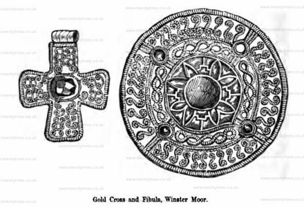
Section I Tumuli 1765. About a mile west of the village of Winster, on the right hand side of the road leading from that place to Pike Hall, once stood a barrow [Map], generally known by the name of White Lowe, which was destroyed in the year 1765 or 1766, by the farmer to whose share it fell, upon the inclosure of the common on which it was situate. On this occasion one of the most interesting and valuable discoveries ever made in the county was casually brought to light; and it is much to be regretted that no systematic account of it was written at the time, and correct draughts of the objects taken, which is now impossible, as one article alone exists of all the valuable deposit (now in the possession of Mr. John Mander, of Bakewell). Such is the dearth of information upon this subject, that little more than a list of the articles can be furnished; premising, however, that they were found in the centre of the barrow, and upon the level of the natural soil, whether in company with a skeleton or not there is no evidence. The list is as follows: two large globular urns, seventeen inches in height and about thirteen in circumference (quere diameter); two glass vessels, about nine inches in height, with wide circular mouths, and a slight bulge in the middle: they were made of yellow glass, extremely thin and light, and when discovered contained about a pint of clear green water; several variegated beads, square and round, both of glass and earthenware; a large bracelet of silver, about an inch broad, joining at the ends in dovetail fashion, and studded with human heads; figures of animals, &c., which were affixed by rivets; also a large circular fibula of gold, set with garnets, or red glass, which was strengthened by being riveted upon a plate of silver, which was assigned to the close of the fifth century by that distinguished antiquary the Rev. James Douglas. In the barrow the glass vessels were placed on each side of the urns, and the other ornaments were lying near them; around them were remains of decayed wood, and pieces of brass in the form of clasps and hinges, which would indicate that the more precious articles had been deposited in a box.
It is highly probable that a small cross of pute gold in the author's museum was discovered in the preceding barrow; the style of workmanship is almost identical with that of the circular fibula just mentioned. It is engraved as a vignette on page 67 of Douglas's 'Nenia Britannica' and by that learned antiquary is considered, notwithstanding its crucial form, to be of an era anterior to the introduction of Christianity into Britain. The only circumstances connected with its discovery that are now to be depended upon are these: it was found in the process of demolishing a tumulus on Winster Common, about the year 1767, and was bought from the labourer who was so fortunate as to find it by the Rev. John Mason, then curate of Winster, who had a taste for antiquities.
Europe, British Isles, North-Central England, Derbyshire, Norbury, Winster Barrow [Map]
Winster Barrow is also in Peak District Bronze Age Barrows.
Archaeologia Volume 3 Section XXIX. Discoveries in a Barrow [Winster Barrow [Map]] in Derbyshire. Communicated by Mr. Mander, of Bakewell, in the said County. Read at the Society of Antiquaries, March 17, 1768.
Winster. On the 13th of October, in consequence of information kindly communicated by Miss Worsley, I went to Winster, a small town about six miles from Bakewell, to see an interment [Winster Barrow [Map]] that had been accidentally discovered by removing a bank of earth in the garden of that lady. There was no external indication of such a deposit having been made, and if any mound had existed it would probably be levelled when the garden was laid out. The bones had been disturbed by the labourers previous to my visit, but it was observed that tbe body bad been placed on the natural surface in a contracted posture, with the head to the north-east; by examining the contents of the grave, it appeared that the deceased had been accompanied by an iron spear head and the lower stone of a quern or hand-mill, the former was broken by the finders. The body was covered with large stones of the same sorts as may be met with in the neighbourhood, yet evidently collected from different places, there being grey waterworn limestones from the surface of the land and other black limestones of a shaly texture that had clearly been quarried. The earth whereon the skeleton lay, exhibited traces of a large fire, and among the ashes were a few particles of calcined bone, together with the remains of wood; many of the stones, including the quern, had also been in the fire. The height of the earth above them was near 5 feet, and it appeared to be quite free from any other stones. I observed the lower jaw of an ox lying about, which was found during the progress of the work, but could not learn that it was connected with the interment, though from discoveries of former years, I am induced to think that it would be. A second interment of similar character was discovered on the following day, about 3 yards further in the bank of earth; the mode of sepulture was in every way identical with the former, and the bones having been, by the judicious kindness of Miss Worsley, preserved untouched for my inspection, I was enabled by removing them myself to make the following observations as to the manner of burial:- A large wood fire was made upon the natural surface, in which the stones used for covering the body, and part at least of the weapons of the deceased, were first burnt, as is abundantly clear from their present condition; after the fire was exhausted, the body was laid on the spot where it had been kindled, upon its right side with the knees drawn up, and the head pointing to the north-east; at the head was placed a small vessel of very coarse and unornamented pottery, much decayed when found; and at the back of the skeleton were laid a very large iron spear head of coarse workmanship, of the unusual length of 2 feet, found with the point towards the feet of the skeleton; a small curved instrument of iron, 5 inches long, originally inserted in a wooden handle, the bone ferule of which still remains; and a bead-formed ring of stoneware or porcelain, 1½ inch diameter, slightly ornamented with two incised lines round the outer edge, and two recessed places, which, but for its brittleness, might have received a pin to constitute it a fibula. After the completion of these arrangements, the stones having been burnt, were carefully placed over the corpse, and earth was finally heaped over the whole to the height of between 4 and 5 feet. It is very remarkable, that amongst the stones around this interment, was found the upper half of the same hand-mill, the lower stone of which was buried with the first skeleton; it is a very neatly wrought example of the bee-hive shaped quern, having both a funnel shaped hopper for the reception of the grain, and a hole at the side for the handle; it is made from the millstone grit of the neighbourhood, obtained probably from Harthill Moor, not more than two miles distant, a locality where numerous pieces of similar querns have been from time to time turned up by cultivating the land. From the great heat to which it had been exposed it was split into several pieces. The human bones were much decayed in consequence, I think, of the corpse having been interred whilst the grave and the surrounding stones were hot; perhaps, however, some more recondite cause must be sought to account for their nearer approximation to their original dust, than those of the other skeleton, which were undoubtedly of contemporary date.
Note A. far as I can judge, both skeletons were of men of ordinary stature, and it is singular that interments of this late period should have been deposited in the ancient contracted position.
I noticed in the last grave one or two bits of calcined bone, and the unburnt tooth of a sheep. The jaws and other bones of a dog, and some shapeless fragments of iron, were found in the earth a little above the interment, before my arrival; and I would observe that another specimen of the large and heavy spear, which consists of a wide socket terminating in a blade, the section of which is rectangular, found in the Thames near Kingston, is in the collection at Lomberdale House [Map], where the foregoing relics are also deposited, by the liberality of Miss Worsley, and her brother, Charles Worsley, Esq.
Europe, British Isles, North-Central England, Derbyshire, Norbury, Wirksworth [Map]
The Street is a Roman Road that travels broadly south from Melandra aka Ardotalia [Map] to Wirksworth [Map] where it joined another road which crossed the Derwent at Milford and ran on the east bank of the Derwent and to Derventio [Map] aka Derby.
For the early stages of the road information had been obtained from P. Wroe and P. Mellor (1971). "A Roman Road between Buxton and Melandra Castle, Glossop (Derbyshire Archaeological Journal 1971, Volume 91).
From Melandra aka Ardotalia [Map] the road heads broadly south through Simmondley [Map], Higher Plainsteads Farm [Map], Abbots Chair [Map], Brookhouses, Hayfield [Map], through Little Hayfield, Derbyshire [Map], Bank Vale, Hayfield [Map]. In Hayfield it appears to have followed Kinder Road [Map] until it reached Spring Vale Road [Map] where it could cross the River Sett where the steep river cliff has ended. It continued more or less straight past Highgate Head Farm, Hayfield [Map], Peep o Day [Map] following the A624 until East Meats [Map] where it heads towards Gorsty Low [Map] then Breckend [Map] and Townend [Map]
In Jun 1754 Hugo Meynell (age 19) and Anne Gell were married at Wirksworth [Map].
After Buxton The Street continues south following the A515 past [Map], Pomeroy [Map], Parsley Hay [Map] where it turns towards Oldham Farm Barrow [Map] and Pikehall [Map] after which it passes Minning Low Chambered Tomb [Map] turning before Brassington [Map] onto Manystones Lane [Map] continuing east into Wirksworth [Map].