Cove
Cove is in Late Neolithic to Early Bronze Age Monuments.
Cove describes a either a three-sided structure, the Avebury Type, formed from upright stones typically at the centre of a Stone Circles or the end of an Avenue, or the Stenness Type: three stones, inline, with the middle offset, as per the following diagram:
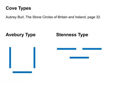
Books, Prehistory Chronologically, Late Neolithic to Early Bronze Age Monuments, Avebury Type Cove
A Avebury Type Cove describes three stones set in a C shape.

Europe, British Isles, South-West England, Somerset, Stanton Drew Cove [Map]![]()
Stanton Drew Cove is also in Avebury Type Cove.
Stanton Drew Cove [Map] is a Avebury Type Cove constructed around 3500BC ±500 years near to the Stanton Drew Stone Circles. It is now in the garden of a local pub. The stones are of a different rock to the stones that form the stone circles. The stones are believed to be the portal stones of a Chambered Tomb rather than an actual Cove; Coves appear to be a later form of monument.
Avebury by William Stukeley. The cove [Map], as most commonly, consists of three stones, set in a half-moon figure, or, to be more exact, upon the end of an ellipsis whose focus, I suppose, would be in a line upon the foremost edges of the two wings. This is situate in the south-west; part of the oval knoll of ground that contains the whole ; at present in an orchard south of the church, and west of the nunnery before mentioned. The wings are standing, but much diminished by age or violence ; some great pieces being broke off: the stone on the back is fallen down, being a larger one: it is 13 foot long, and 8 broad; therefore of the same dimensions with Hautvil's Coyt [Map], before spoken of. This cove opens to the south-east.
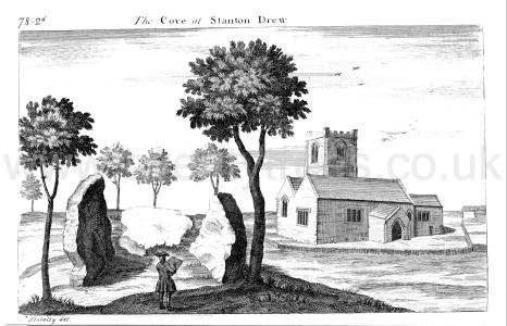
History of Somerset: Stanton Drew. This part, though in itself immense, and occupying a large extent of ground, appears to be only the centre of the stupendous building. Doubtless there were many avenues to it, and Hautville's-coit seems to have served as part of a portal to one of them. There were also other outworks, one of which [Stanton Drew Cove [Map]], consisting of three prodigious stones, placed in a triangular form, still remains on a small eminence, in an orchard belonging to Mr. Fowler, southwest from the church. Two of these ftones are standing; the largest measuring ten feet in height, and six feet and a half in width; the one that is fallen is fourteen feet long, and eight feet wide.1
Note 1. Notes taken April 9, 1789.
Memoirs Historical and Topographical of Bristol Volume 1 Chapter. 99. North-west from the last circle, little more than 100 yards distant, is a Core [Stanton Drew Cove [Map]], ten feet wide and about eight feet deep, formed of three large flat stones 18 inches thick: they are reckoned by Wood to be 992 feet from the centre of the great circle. The stone which formed the back is thrown down, and apparently two corners are broken out: it is 13 feet long, perhaps two feet of it were underground. The south-western stone is standing in it's place, eleven feet high. The north-eastern is standing, only five feet high; whether it was once higher, which is probable, cannot be ascertained. Such coves are supposed to have been erected for judicial purposes, where the Druids sat and administered justice to the neighbouring tribe. This cove [Map] is within a stone's throw from the Church of Stanton Drew.
Proceedings of the Somerset Archaeological and Natural History Society Volume 14 Pages 161-172. The Cove [Map] is situated a little to the south-west of the parish church, and is formed by three stones standing in an orchard. The two side stones are still standing, but that which formed the back is fallen down. These three stones are 18 inches thick, and the respective lengths of from 10 to 14 feet. The cove [Map] is 10 feet wide and about 8 feet deep, and opens to the south-east.1 The first circle is distant 157 yards from this cove [Map] in an easterly direction the number of stones which originally composed the circle appears to have been twelve, and the diameter of the circle, according to Mr. Crocker, is 129 feet. There are now remaining in the orchard, in w'hich it is partly situated six stones, and three in the adjoining field, and one under the wall which separates the orchard from the field, making ten in all; but the circle when complete probably con sisted of twelve. 150 yards from this circle in a north east direction, is the Great Circle, the diameter of which, according to Mr. Crocker^s measurement, is from east to west 345 feet, and from north to south 378 feet. It is therefore, strictly speaking, an ellipse, with the longer axis from north to south. The number of stones remaining is fourteen, of which three only are standing, others are said to be beneath the surface. The tallest of the standing stones is 7J feet high, and about 6 feet thick. They are all of a very rude appearance. The original number was probably twenty-four. Seyer says twenty-seven.
Note 1. See Stukeley’s Itin. Curiosum.
Long Barrows of the Cotswolds. "Stukeley himself notices that 'the very same report remains at the Druid temple of Stanton Drew,' Somersetshire. 'This noble monument is vulgarly called the Weddings; and they say'tis a company at a nuptial solemnity thus petrify'd. In an orchard near the church is a cove [Map] consisting of three stones like that of the northern circle in Abury or that of Longstones; this they call the parson, the bride, and bridegroom. Other circles are said to be the company dancing; and a separate parcel of stones standing a little from the rest are call'd the fidlers, or the band of musick.'
Archaeological Journal Volume 15 Pages 199-215. We will first direct our attention to the three stones in the orchard on the higher ground to the south of the church, and which form what Stukeley called The Cove [Map]. The two side stones are standing, and that which formed the back is fallen down. These three stones are 18 inches thick; the prostrate one, of which, perhaps, 2 feet were under ground, is, according to Collinson, 14 feet long, and 8 feet wide; the taller of the two which are upright is 10 feet high and in width; the other is only 5 feet high. Stukeley makes the recumbent stone "13 foot long, and 8 broad." Seyer says it is 13 feet long, and that the south western of the standing stones is 11 feet high. " Whether it was once higher, which is probable, cannot be ascertained." The Cove [Map] is 10 feet wide, and about 8 deep, and opens to the south-east. The best print I have seen of it is that given by Stukeley in the Itinerarium Curiosum.
Books, Prehistory Chronologically, Late Neolithic to Early Bronze Age Monuments, Stenness Type Cove ![]()
A Stenness Type Cove describes three stones, inline, with the centre stone offset, as per the diagram:

3100BC. The Stones of Stenness [Map] is a Henge and Stone Circles erected around 3100BC based on radio-carbon dating; it isn't clear who undertook the dating? Aubrey Burl, in his book "A Guide to the Stone Circles of Britain, Ireland and Brittany", states "The setting [Stenness Type Cove] had consisted of three erect stones, two in line side by side, N-S, separated by a narrow gap behind which the third stood like the backstone of a chamber. It is a form of Cove./
Arbor Low Henge and Stone Circle [Map]. Aubrey Burl, in his book "A Guide to the Stone Circles of Britain, Ireland and Brittany", states "The three sided Cove is now prostrate, two huge sides tumbled outwards, a long low stone on edge like a sill or septal slab between them at the east and other little stones nearby. A skeleton of a man about 5ft 5ins tall was buried againbst the eastern corner. Immediately east was a deep pit with a human armbone in it. "It is possible", wtrote the excavator, "That a skeleton or skeltons may have been removed from here".
Europe, British Isles, North-Central England, Derbyshire Dales, Bakewell, Arbor Low Henge and Stone Circle [Map]![]()
Arbor Low Henge and Stone Circle is also in Peak District Henges, Peak District Stone Circles, Stenness Type Cove.
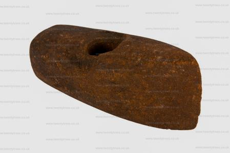
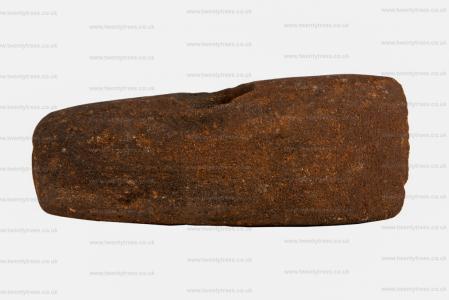
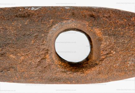
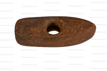
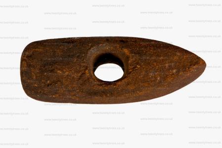
Between 2500BC and 700BC. Stone axehammer found at Arbor Low [Map]. In the collection of Buxton Museum and Art Gallery [Map]. Width 56mm; length 177mm; depth 57mm; diameter of hole 27mm.
Between 2500BC and 1500BC. Discoidal flint knife found at Arbor Low [Map]. In the collection of Buxton Museum and Art Gallery [Map]. Height 11mm; width 74mm; length 97mm; depth 3mm; diameter mm. This tool was purchased from a local farmer by Micah Salt in 1897. Micah Salt (1847-1915) was a tailor in Buxton who had a great interest in archaeology.
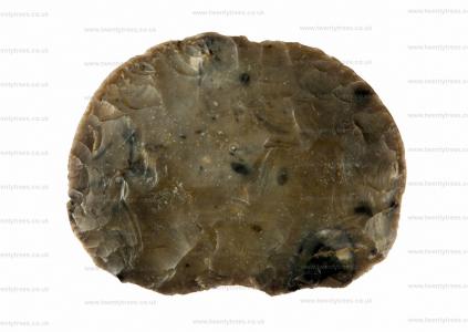
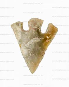
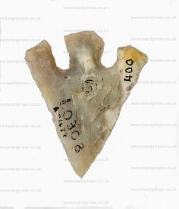
Between 2500BC and 2000BC. Barbed-and-tanged flint arrowhead found at Arbor Low [Map]. In the collection of Buxton Museum and Art Gallery [Map].
Derbyshire Archaeological Journal Volume 30 1908 Page 155. 10 Jun 1761[Fol. 45.]
Copied from MS of John Mander, of Bakewell.
Arbourlows [Map] viewed by Mr Pegge and myself, 10 June 1761.
There are 2 in the enclosed commons adjoining One Ash ground, the great one is environed (a) by a great circular rampire, whose height sloping is about 7 yards, the foss four yards (b) over, the area (c) flat of 50 yards diameter; round which are 32 very large limestone slabs formerly erect, now flat. This Mr Pegge called a British temple. It has two entrances, one to the East, another to the West1. From that to the East runs a smail rampire, winding south westwardly to the 2nd low (D) at the distance of about 4 or 500 yards2. On the NE3 side of the temple near the last entrance upon the rampire stands a large low, or mount of earth supposed a great barrow and is properly the low.
The low D4 is about 18 feet diameter at top, with a large hollow in the middle of its area summitt after the form of a bason, on the S side is a small faint rampire5 of earth with several breaks in it running across the field (at the distance of about 70 feet from the low) from the wall on the W, and across under the wall on wall to the E. N.B., On the W side of the western wall we could find no traces of this rampire, nor any place where it turned. This rampire crossing the Eastern wall as was said before passes quite to the foot of the great rampire of the temple."
Note 1. Mr Manders evidently had the compass bearings on the plan referred to in this MS., wrong. The entrances of the circle are nearly due north and south, and the tumulus is on the south-east.
Note 2. Gib Hill [Map], but its actual distance from the circle is about 300 yds. It is constantly stated by the older writers that this tumulus was connected with the circle by a "rampire." This, however, upon leaving the latter, does not point to Gib Hill [Map], but has a southerly course for about 200 yards, after which it curves to the west, but with a bearing considerably south of the latter, and is then lost. The recent excavations proved that it consists of a small bank and ditch.
Note 3. This tumulus is on the sonth-east.
Note 5. From personal observations, this is very doubtful (J.W.).
Derbyshire Archaeological Journal Volume 30 1908 Page 155. 29 Jun 1782. Arber low [Map] 29: June 1782.
Qy of its addition Rink? Mr. Rook thinks this to be the most ancient and capital monument of antiquity in the Kingdom, and upon a plan full as large as Stonehenge, but vastly more ancient. That in every such place each stone had its name, before which stones the respective chiefs stood in their general assemblies, and every one knew his own stone, which bore his name of office, as King stone, &c. Rinch, Ringh, Ring from Winshew Curium rotendum. The temple here is certainly round, and if no circumstance of a barrow appears in the Mount now (June 29th 1782) opening, it should seem to be more like a court, when the assemblies of the ancient Britons with their chiefs were used to be held. Compare it with Vernometum in Leicestershire.
Archaeologia Volume 7 Section XIII. A Disquisition on the Lows or Barrows in the Peak of Derbyshire, particularly that capital British Monument called Arbelows [Map]. By the Rev. Mr. Pegge (age 80).
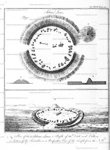
James Pilkington 1789. In this hamlet is one of the most striking monuments of antiquity, which is to be met with in Derbyshire. It is about a mile and a half distant from Newhaven, and is known by the name of Arbelows, or Arbor-low [Map].
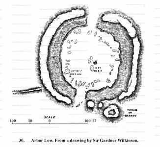
This ancient remain consists of an area, encompassed by a broad ditch, which is bounded by a high mound or bank; and the form of the whole is nearly that of an ellypsis, or imperfect circle.
The area B. B. measures from east to west forty- fix yards, and fifty-two in the contrary direction. The width of the ditch C. C. is fix, and the height of the bank D. D. on the inside five yards. The height is continually varying throughout the whole circumference; but is at a medium what I have now mentioned.
The bank has evidently been formed from the soil, which has been thrown out of the ditch, but it is not carried entirely round the area. To the north and south there is an opening, or passage F. F. about fourteen yards wide. On the east side of the southern one is also a small mount or barrow E. This stands in the same line of circumference with the bank, but is entirely detached from it.
Arthur Jewitt 1811. Newhaven Inn
This inn is a late erection of the Duke of Devonshire's, besides which, he has just finished another, at a little distance from it; the latter being chiefly designed for the accommodation of carriers, &c. and the former, for travellers of a superior class.
At a short distance from Newhaven, is perhaps the finest piece of antiquity in this part of the country; it is called Arbor-lowe [Map], or Arbe-lowes, and is supposed to be the remains of a druidical temple. It is composed of a circle of large stones, about 150 feet in diameter, surrounded by a bank, the sloping side of which measures nearly 33 feet. This curiosity is particularly described by Mr. Pilkington, in his Present State of Derbyshire, and is illustrated by an accurate view of it, as it stood about the year 1780.
A mile beyond Newhaven Inn, and about the same distance from the road, toward the right hand, is another antiquity, also described by Mr. Pilkington, called Wolves'-cote-lowe, which stands on the top of Wolves'-cote, ( or as it is there called Wuss-cote ) hill. It is a barrow very much resembling that described at Chelmorton; the circumference of its base is about 70 yards.
Derbyshire Archaeological Journal Volume 30 1908 Page 155. [Fol. 44.]
June 1st 1824. Examined William Normanshaw of Middleton aged 74 years, son of W. Normanshaw mentioned by Pegge. He says he has repeatedly heard his father (who died about 20 years ago at the age of 90) say that he remembered the stones in the circle at Arborlow [Map]; many of them standing, more erect than they do now1. Does not think they have undergone much alteration in position in his own remembrance. Recollects Major Rook opening the low they found the horns of a stag - once dug into the side of the barrow belonging to T. Bateman Esquire for stone, when he found the scull of a human being.
Note 1. This tends to confirm Pilkington's statement: I have been informed, that a very old man, living in Middleton, remembers, when he was a boy, to have seen them (the stones), standing obliquely upon one end." - A View of the Present State of Derbyshire, II., p. 460 ( 1789). Statements of this sort, however, must be accepted tun grano salis [with a grain of salt]. An old man employed in Mr. H. St. George Gray's recent excavation assured him that he had seen five of the stones standing when he was a boy and had sheltered under them. But it should be noticed that none of these statements imply that any of these stones were seen standing vertically on end. They simply imply that in comparatively recent times some were obliquely elevated, a conceivable attitude in the process of gradual subsidence.
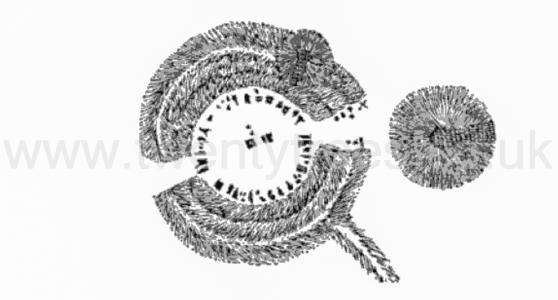
Stephen Glover 1831. Between two and three miles north—east of Newhaven, at a little distance beyond the Roman road from Buxton to Little Chester, is one of the most remarkable monuments of antiquity in Derbyshire. This is the Arbor-Low or Arbelows [Map], a druidical circle, surrounded by a ditch and vallum. Its situation, though considerably elevated, is not high as some eminences in the neighbouring country ; yet it commands an extensive view, especially to the north-east. The area, encompassed by the ditch, is about fifty yards in diameter, and of a circularfurm ; though, from a little declination of the ground towards the north, it appears somewhat elliptical, when viewed from particular points. The stones which compose the circle are rough and unhewn masses of limestone, apparently thirty in number; but this cannot be determined with certainty, as several are broken. Most of them are from six to eight feet in length, and three or four broad in the widest part; their thickness is more variable, and their respective shapes are different. They all lie on the ground, and generally in an oblique position; but the opinion that has prevailed, of the narrowest end of each being pointed towards the centre, in order to represent the rays of the sun, and prove that luminary to have been the object of worship, must have arisen from inaccurate observation: for they almost as frequently point towards the ditch as otherwise. Whether they ever stood upright, as most of the stones of druidical circles do, is an enquiry not to determine; though Mr. Pilkington was informed, that a very old man living in Middleton, remembered, when a boy, to have seen them standing obliquely upon one end. This secondary kind of evidence does not seem entitled to much credit as the view of the stones themselves and their relative situations are almost demonstrative of the contrary. Within the circle are some smaller stones scattered irregularly and near the centre are three larger ones erroneously supposed to have once formed a cromlech The width of the ditch which immediately surrounds the area on which the stones are placed is about six yards the height of the bank or vallum on the inside is from six to eight yards but this varies throughout the whole circumference which on the top is nearly two hundred and seventy yards. The vallum seems to have been formed of the earth thrown up from the ditch. To the enclosed area are two entrances each of the width of ten or twelve yards and opening on the north and south. On the east side of the southern entrance is a large barrow standing in the same line of circumference as the vallum but wholly detached excepting at the bottom. This barrow was opened in June 1782 by H Rooke esq and the horns of a stag were discovered in it and June 1 1824 by Mr Samuel Mitchell (age 27) of Sheffield and the engraving here inserted is copied from an accurate drawing made by that gentleman.
Section II Circles. By far the most important, as well as the most uninjured, remain of the religious edifices of our barbarous forefathers that is to be found in the midland counties, is to be seen a short distance to the left hand of the turnpike road from Buxton to Ashbourne, at about an equal distance from each of those towns. This is the famous temple of Arbor Lowe, or Arbe Lowe [Map], as it is generally called by the country people; it is a circle of large unhewn limestones, surrounded by a deep ditch, outside of which rises a large and high vallum. Its situation, though considerably elevated, is not so high as some eminences in the neighbouring country; yet it commands an extensive view, especially towards the north-east, in which direction the dreary and sombre wastes of the heath-clad East Moor are perfectly visible, though distant about fifteen miles; were it not for a few stone fences, which intervene in the foreground, the solitude of the place and the boundless view of an uncultivated country are such as almost carry the observer back through a multitude of centuries, and make him believe that he sees the same view and the same state of things as existed in the days of the architects of this once holy fane.
Section II Circles. The feelings on visiting this place [Arbor Low Henge and Stone Circle [Map]], on a warm summer's day, when there is no sound to disturb the solitude, save the singing of the lark, and now and then the cry of the plover (both which here abound), are truly delightful. But to resume the description; the area encompassed by the ditch is about fifty yards in diameter, and of a circular form; though, from a little declination of the ground towards the north, it appears somewhat elliptical when viewed from particular points. The stones which compose the circle are rough, unhewn masses of limestone, apparently thirty in number; but this cannot be determined with certainty, as several of them are broken; most of them are from six to eight feet in length, and three or four broad in the widest part.; their thickness is more variable, and their respective shapes are different and indescribable. They all lie upon the ground, many in an oblique position, but the opinion that has prevailed, of the narrowest end of each being pointed towards the centre, in order to represent the rays of the sun, and prove that luminary to have been the object of worship, must have arisen from inaccurate observation, for they almost as frequently point towards the ditch as otherwise; whether they ever stood upright, as most of the stones of druidical circles do, is an inquiry not easy to determine; though Mr. Pilkington was informed that a very old man, living in Middleton, remembered, when a boy, to have seen them standing obliquely on one end; this secondary kind of evidence does not seem entitled to much credit, as the soil at the basis of the stones does not appear to have ever been removed to a depth sufficient to ensure the possibility of the stones being placed in an erect position. Within the circle are some smaller stones scattered irregularly, and near the centre are three larger ones, by some supposed to have formed a cromlech or altar, but there are no perceptible grounds for such an opinion. The width of the ditch, which immediately surrounds the area on which the stones are placed, is about six yards; the height of the bank or vallum, on the inside (though much reduced by the unsparing hand of time), is still from six to eight yards; but this varies throughout the whole circumference, which, on the top, is about two hundred and seventy yards. The vallum is chiefly formed of the earth thrown out of the ditch, besides which a little has been added from the ground which immediately surrounds the exterior of the vallum, thus adding to its height, and to the imposing appearance it presents to any one approaching from a distance. To the inclosed area are two entrances, each of the width of ten or twelve yards, and opening towards the north and south.
Journal of the British Archaeological Association Volume 16 Page 101. and a still more remarkable instance occurs at Arbe Low [Map]1 in Derbyshire. (See pl. 9.) This has two entrances. The inner platform is 167 feet in diameter, and the ditch is 18 feet broad at the bottom. The stones are small compared to those of Abury, the largest belonging to the circle measuring 13 feet by 7; while one of the largest at Abury measures from 14 to 18 feet in length, 12 feet 3 inches in height, and 7 feet (varying to 2 feet 4 inches) in thickness : and the platform of Abury has an average diameter of 1,130 feet. The agger of Arbor Low is still about 15 to 18 feet high, or from 20 to 24 to the bottom of the ditch; and the circumference at the top of it is nearly 820 feet.
It has been stated that the narrow end of the stones points to the centre of the circle; but as Mr. Bateman2 justly remarks, it points as often towards the ditch ; and instead of radiating to or from the centre, as if to imitate the sun's rays, they lie in the direction in which they have fallen : for it is evident that they originally stood upright, as in other sacred circles; and the notion of those who doubt it is evidently erroneous, as some are even now in an oblique position, the upper end not having yet reached the ground ; confirming the statement of an old man, mentioned by Mr. Bateman, who declared that he had seen them standing obliquely on one end. The entrances open towards the north and south, and the two passages leading from them to the platform measure each about 27 feet in breadth.
Rude Stone Monuments in all Countries Chapter IV. The principal monument of this group is well-known to antiquaries as Arbe or Arbor Low [Map], and is situated about nine miles south by east from Buxton, and by a curious coincidence is placed in the same relative position to the Roman Road as Avebury. So much is this the case, that in the Ordnance Survey—barring the scale—the one might be mistaken for the other if cut out from the neighbouring objects. Minning Low [Map], however, which is the pendant of Silbury Hill in this group, is four miles off, though still in the line of the Roman road, instead of only one mile, as in the Wiltshire example. Besides, there is a most interesting Saxon Low at Benty Grange, about one mile from Arbor Low. Gib Hill, Kens Low, Ringham Low, End Low, Lean Low, and probably altogether ten or twelve important mounds covering a space five miles in one direction, by one and a half to two miles across.
Note 165. First described in the 'Archæologia,' vol. viii. p. 131 et seq., by the Rev. S. Pegge, in 1783.
Arbor Low consists of a circular platform, 167 feet in diameter, surrounded by a ditch 18 feet broad at bottom, the earth taken from which has been used to form a rampart about 15 feet to 18 feet high, and measuring about 820 feet in circumference on the top. The first thing that strikes us on looking at the plan (woodcut No. 30) is that, in design and general dimensions, the monument is identical with that called "Arthur's Round Table," at Penrith. The one difference is that, in this instance, the section of the ditch, and consequently that of the rampart, have been increased at the expense of the berm; but the arrangements of both are the same, and so are the internal and external dimensions. At Arbor Low there are two entrances across the ditch, as there was in the Cumberland and Dumfriesshire examples. As mentioned above, only one is now visible there, the other having been obliterated by the road, but the two circles are in other respects so similar as to leave very little doubt as to their true features.
John Lubbock 1879. Arbor Low [Map]1 By Sir John Lubbock (age 44), Bart., M.P., F.R.S., F.S.A.
Note 1. I have to express my profound indebtedness to Sir John Lubbock, for permitting the "Reliquary" to be the medium of giving to the antiquarian world this important paper, read by him, on the spot-at Arbor Low itself-before the Members of the British Association, on the 23rd of August, in the present autumn. Sir John in the hand, placed his MS. in my hands for publication, and I feel that by so doing he has not only conferred a favour on myself, but a great boon on all of archæology. L. JEWITT (age 62).
Harold Gray 1902. Arbor Low Stone Circle [Map] Excavations in 1901 and 1902. By H. St. George Gray (age 29)
The following is an abstract of a paper communicated to the Society of Antiquaries by Mr. Gray, in April, 1903, and printed in Archæologia, Vol. lviii., pp. 461-498. By kind permission of the Society liberal use has been made of Mr. Gray's paper, and the proofs have been revised by him. We are further indebted to the society for the loan of most of the illustrations in Archæologia, but the size of these pages has necessitated considerable reduction of the plan.
Arbor Low Henge and Stone Circle [Map]. Aubrey Burl, in his book "A Guide to the Stone Circles of Britain, Ireland and Brittany", states "The three sided Cove is now prostrate, two huge sides tumbled outwards, a long low stone on edge like a sill or septal slab between them at the east and other little stones nearby. A skeleton of a man about 5ft 5ins tall was buried againbst the eastern corner. Immediately east was a deep pit with a human armbone in it. "It is possible", wtrote the excavator, "That a skeleton or skeltons may have been removed from here".
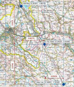
Arbor Low Five Wells Bull Ring Monument describes a possible prehistoric single monument formed from Arbor Low Henge and Stone Circle [Map], Five Wells Chambered Tomb [Map] and the Bull Ring Henge [Map] that form the same shape as the constellation Orion's Belt.
Other prehistric monuments including the Thornborough Henges, and, possibly, the Giza Pyramids appear to be similar. There are theories about there being a 'Cult of Orion' around 2400BC. Both Arbor Low Henge and Stone Circle [Map] and Bull Ring Henge [Map] can be seen from Five Wells Chambered Tomb [Map] albeit not with the naked eye during daylight - a camera with a long lens is needed. In darkness a bonfire would make both easily visible.
Taking the positions of each map from Historic England's listing the angle between the monuments is 172 degrees which is consistent with the angle of Orion's Belt. The angle of Orion's belt may have changed over time - difficult to find an exact figure. And, of course, difficult to be precise as to the centre of each monument so error is likely. I couldn't find a description of the linear distance between the stars seen from earth. If anyone has better information please email email@twentytrees.co.uk.
The Reliquary Volume 18 Page 49. On Arbor Low [Map] IV by William Henry Goss.
Caesar, speaking of human sacrifices among the Gauls, says, "Those who are afflicted with any grievous distemper, or whose lives are hazarded in war or exposed to other dangers, either offer up men for sacrifices, or vow to do so ; and they make use of the Druids for their priests on such occasions, imagining their gods are to be satisfied no other way for sparing their lives than by offering up the life of another man." We have learned that the Druids of Gaul came into Britain for initiation into the mysteries of their dreadful office. Is it not possible that some of them took lessons within this same circle of Arbor Low [Map]? Tacitus mentions that the ancient Germans sacrificed human victims to their gods, and Procopius Ceesariensis affirms that in his day, in the sixth century of our Lord, the Druids of Gaul still offered human sacrifices, and I have already referred to Charlemagne's edict against the practice so late as the year 789 A.D.
Derbyshire Archaeological Journal. Some Notes of Arbor Low [Map] and other Lows in the High Peak by Arthur T Matthews
Many excellent descriptions of Arbor Low have been published, but a few points, which appear to me of interest, have not, so far as I have been able to ascertain, been noted.
Arbor Low is about a mile from Parsley Hay Station, on the northerly slope of a hill which rises somewhat to the south, the centre of the circle,, being 1,231 feet above the Ordnance Datum.
Why was it not placed on the summit?
Arbor Low is in latitude 53° 10¼ N. and longitude 1° 45½ W.; Stonehenge is in latitude 51° 11 N. and longitude 1° 49 W. (The latitude and longitude of Arbor Low are taken from the Ordnance map; those of Stonehenge are as given in Stanford's, London Atlas.)
Thus Arbor Low is nearly due north of Stonehenge, and still more exactly two degrees of latitude to the north. The division of the circle into 360 degrees is very ancient; it was used by Ptolemy in the Almagest, and probably long before his time, so that the double coincidence is noteworthy.
In the middle of the southern gateway of Arbor Low there is an isolated stone right away from the circle," broken off, but with the base still in position. This stone is sharply pointed, and is due south of the centre of the "circle". I take it to have been the marker of high noon. This stone is shown on Mr. Gray's plan, but is not numbered call it the south pointer,
Blacks Guide to Derbyshire. Parsley Hay, where, on getting out of the train, one sees hardly any houses but the forlorn little terminus, and must turn up the road for a modest refreshment room, is also the station for Arbor Low [Map], the Derbyshire Stonehenge, that stands conspicuously elevated a mile to the east on the south of the Bakewell Road. Its Druidical circle, which comes next in importance to those of Stonehenge and Avebury, consists of overthrown stones, mostly 6 to 8 feet high, lying disordered on a platform about 50 yards in diameter, surrounded by a wide ditch. On the east side of the south entrance is a large barrow, the exploration of which has proved the antiquity of this "high place." Some quarter of a mile westwards is another conical tumulus known as Gib Hill [Map], connected with Arbor Low by a bank of earth. On this side the Roman road can be traced, taking its straighter line near the modem turnpike, with which it in part coincides.
Only the present remoteness of Arbor Low prevents it from being more often visited. "Its situation, though considerably elevated, is not so high as some eminences in the neighbouring country; yet it commands an extensive view, especially towards the north-east, in which direction the dreary and sombre wastes of the heath-clad East Moor are perfectly visible, though distant about 15 miles; were it not for a few stone fences, which intervene in the foreground, the solitude of the place and the boundless view of an uncultivated country are such as almost carry the observer back through a multitude of centuries, and make him believe that he sees the same view, and the same state of things as existed in the days of the architects of this once holy fane." — Bateman's Vestiges of the Antiquities of Derbyshire.