Archaeologia Volume 6 Section XIII
Archaeologia Volume 6 Section XIII is in Archaeologia Volume 6.
An account of some Druidical Remains on Stanton and Hartle Moor in the Peak, Derbyshire. By Hayman Rooke (age 57), Esq. Read April 6, 1780.
Stanton Moor is twenty-four miles from Derby, twelve from Chesterfield, and four from Bakewell, a wild uncultivated waste, very high land, rocky, and produces a coarse kind of sedgey grass; it is about two miles in length from north to south, and near one and a half in breadth from east to west; bounded on the north by Rowsley, on the east by Darleydale, a beautiful valley, finely diversified with woods, villages, and rich pasture, and where the Derwent forms a meandering course from north to south; it is bounded on the west by Hartle Liberty or Hartle Moor.
At the south end of Stanton Moor, close to the village of Birchover, is a very singular mass of large rocks, called Roulter, Rowter, or Roo-Tor; whence Rowter means a moving rock, since in the provincial dialect they will s a thing roos backward and forward: now this Roo is no other than Rou, it being the usual pronunciation of the country, the inhabitants generally omitting the final l and ll.; wall, they pronounce wo; hall, ho; fall, fo, &c. These rocks stand on the top of a hill, commanding an extensive view over the moor, and seem to have been a place much frequented by the Druids.
Plate XII N° I. is a south view of Rowter rocks [Map], where (a) is a rock bason. The pillar on the top was set up a few years ago to support a weather-cock..
N° 2. is a south-well: view of Rowter rocks, with the rocking stone marked (b); the circumference of which is twenty-eight feet seven inches. There are several caves among these rocks on the north side.
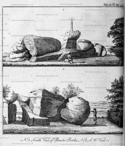
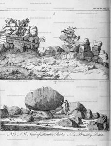
Plate XIII. N° 3. is a north-west view of the rocks from the side of the hill. Many of these stones appear, from their situation, to have been placed by art: the stone N° 1. is evidently put to support the upper stone N° 2. near which is another rock bason.
N° 4. is a north view of an assemblage of large rocks, called Bradley rocks. They stand about a quarter of a mile west of Rowter, on a similar kind of hill: the largest of these is a rocking stone, marked 1, thirty-two feet in circumference; it moves with great ease, and seems, from its extraordinary position, to have been placed there by human strength; it rests upon two, stones clear of the ground, and, if one may judge from its situation, and from the passage between the two stones it rests upon I should suppose it to have been a stone Deity. It answers to the description given by doctor Borlase of rock idols in Cornwall, called Tolmens. He says, one thing is remarkable, which is, "that these Tolmens rest upon supporters, and do not touch" the earth, agreeable to an established principle of the Druids, who thought every thing that was sacred would be profaned by "touching the ground, and therefore, as I imagine, ordered it" so as that these Deities should rest upon the pure rock, and not be defiled by touching the common earth."
In Plate XIV. N° 5. are plans of rock basons, at about a quarter of a mile west of Bradley rocks. On a hill stands another group, called Carciff or Crackcliff. Among these are four very perfect rock basons. That marked 1 is on the top of Rowter rocks [Map], the stone nine feet by seven feet eleven inches; the diameter of the bason at the top two feet seven inches by one foot eleven inches; the other four are on the top of Cardiff. N° 2. stands close to a precipice, too hazardous to measure. The stone No 3. is seven feet in length, diameter of the bason two feet. The stone N° 4. is five feet, the bason two feet fix inches. The stone N° 5. is nine feet four inches, the larger bason three feet diameter, the other two feet. These basons appear to have been the work of art, and have in many places the marks of the tool. On the east and west side of Stanton Moor are several large rocks and stones, none of which have basons, nor are they to be found but on rocks that stand on hills, and in the neighbourhood of Druidical remains.
Plate XIV. N° 6. is a ground plan and view of a hermitage in a cave at the foot of Carcliff rocks. At the east end of the cave is a crucifix, the figure three feet high, cut out of the solid rock in high relief, the sculpture not bad; on the top of the cross there appears to have been something like letters, but now so defaced by time as not to be made out; on the left hand of the crucifix is a niche, as if intended for a statue. Facing the entrance are the remains of seats hewed out of the rock. The length of the cave from east to west is eleven feet; depth to the seats marked 1 nine feet, from the seats to the corner five feet. This little recess seems to have been the bed place of the hermit, and has been separated from the seats by rails, as appears from the holes marked 2. Height of the cave seven feet.
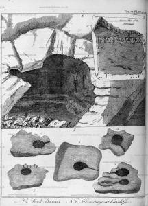
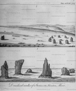
Plate XV. N° 7. is a view or a Druid temple of nine stones on Stanton Moor [Map], about half a mile north of Rowter. It is called by the country people the Nine Ladies. At thirty-four yards west of the temple is a single stone [King Stone, Stanton Moor [Map]], which they have named the King. The diameter of the circle eleven yards; the stones are about two feet fix inches high.; there appears to have been one in the centre. Near it are several cairns; one had been opened a few years ago, and much rummaged: bones were found with a large blue glass bead with orifices not larger than the tip of a tobacco-pipe. One of these cairns 40 feet in diameter is engraved in Plate XVI a.
Plate XV. N° 8. is a view of the remains of another Druid temple on Hartle Moor, about half a mile west of the Nine Ladies. It consists at present only of six ftones; but the field they stand in goes by the name of the Nine Stone Close [Map], and if we may judge by the eye, there were formerly that number. The height of the tailest stone is seventeen feet; at seventy-five yards south stand two stones somewhat smaller.

Plate XVI. N° 9. is a plan drawn by a scale of 40 feet to an inch of a circular British work called Castle Ring [Map], about two hundred yards north from the above mentioned temple, and a quarter of a mile west of the little valley which separates Hartle Moor from Stanton Moor. It has a deep ditch and double vallum; the entrance is very visible on the south east side, where part of the vallum has been levelled by the plough. The diameter from north-east to south-west is one hundred and forty-three feet, from south-east to north-west one hundred and fixty-five feet. As no coins or Roman utensils have been found near it, there seems to be sufficient grounds to suppofe it to be a British and not a Roman encampment. It has been thought by some to have been a Danish work; certain it is that the Danes secured themselves for some time in Derby, after they had driven out the Saxons; but as this place is a great distance from that town, from its vicinity to many Druidical remains I should rather suppose it to be British.
N° 10. is a view of Cats Stones [Map]. At the east side of Stanton Moor are three very remarkable stones; they stand at the edge of a declivity looking over Darleydale, and about a quarter of a mile from each other in a north and south direction. They have at a distance much the appearance of towers: that to the south is called Cats Stone, and has a road leading to it cut through a surface of loose stones and rock: this was evidently intended as an approach to the stone, where it ends, and meets a precipice.
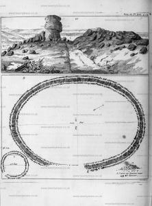
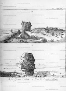
Plate XVII. N° II. is a view of a stone called Gorse Stone [Map], with Cat Stone at a distance marked I. This name is undoubtedly derived from a British word gorsed dau (setting aloft). Doctor Borlace says, in his Antiquities of Cornwall, that the Druids had places of elevation "called gorsed dau; in some places they were made of earth, and sometimes they were upon high rocks, from whence they used to pronounce their decrees." Now no place seems to be better calculated for that purpose, or for their inaugurations, than these stones; the other, which is the largest of the three, is called Heart Stone [Map], and measures eighty-three feet in circumference.
N° 12. is a stone of a very singular fhape, called Andle Stone [Map]. It stands by itself on Stanton Moor, about a quarter of a mile north of Rowter; it seems to have been formed by art, and might probably have been a rock idol.
In Plate XVI. b is a plan of a small work on the middle of Stanton Moor, sixteen yards diameter; the vallum is of earth and stones, but there does not appear to have been a ditch: the entrance is towards the south. There are feveral cairns near it, and many traces of British works are perceivable on various parts of the Moor, but nothing perfect can be made out.

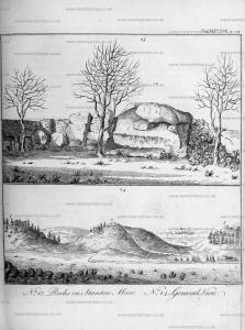
Plate XVIII. N° 13. is a view of some rocks in a small enclosure at the north-west end of the Moor near the village of Stanton. The rock marked (1) is very remarkable; the top is sloping, on which a very large stone marked (2) is supported by the two stones (3) and (4). From the form of these two, (which if they were turned on their edges might support the upper stone in the nature of a cromlech, whence one may reasonably suppose the whole to have been a cromlech, by some means now thrown down), it certainly must have been the work of art. The Druids undoubtedly had a power (unknown to us) of moving very large stones, as is now visible in many of their stupendous remains in England. The ground these rocks stand in belonged to the family of the Caltons, whose ancestor about one hundred and fifty years ago had a Latin inscription, cut in Roman capitals, on the two rocks N° 5 and 6, which is as follows: on 5, Res rustica quæ fine dubitatione proxime et quasi consanguinea sapientiæ est, tam discentibus eget quam magistris1. On the stone N° 6, Nihil est homini libero dignius, et quod mihi ad sapientis vitam proxime videtur accedere.
N° 14. is a north-east view of the three hills at the south end of Stanton Moor, on the top of which are the Druidical remains. N° 1. Rowter rocks; N° 2. Bradley rocks; N° 3. Cardiff rocks; N° 4. the village of Elton.
Note 1. Google Translate: The rustic subject, which is close to the end of uncertainty and as if related to wisdom, needs both students and teachers.
Note 2. Google Translate: Nothing is more worthy of a free man, and that seems to me to approach the life of a wise man.
By the number of Druidical remains on Stanton Moor, we may reasonably suppose this place to have been inhabited by the Druids. Here are temples, caves, rock bafons, rocking stones, gorfed daus, rock idols and cairns. Their sacred groves have long since given way to cultivation; but their more durable monuments have stood the ravages of time, and remain as helps to illustrate their history.