CWAAS Transactions 1923 Volume 23
CWAAS Transactions 1923 Volume 23 is in CWAAS Transactions.
Victorian Books, Cumberland and Westmorland Antiquarian and Archaeological Society, CWAAS Transactions 1923 Volume 23 Article V
Article. V.—Antiquities At Dean. By J. R. Mason. Read At Carlisle, April 6th, 1922.
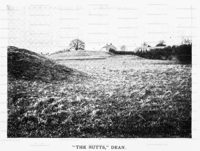
A Freestone boulder, "hogback" in shape, measuring along its base 26 inches, across base 12 inches, in height 15 inches, was found in 1918 when ploughing a field which had not been ploughed for many years (if ever) before, at Dean. The site is about 300 yards from the church and adj oining a field in which are two mounds which look like the sites of archery butts and are so regarded locally, but which may be of earlier date. In the same field is a hill called PARK HILL, known locally as a Roman Camp or Fort, but which may be British: at the foot of this hill are the "parallel trenches" referred to by the late Mr. W. Dickinson in these Transactions, o.s., iii, page 345. Writing of the trenches he says "they are called hiding places of the Britons of old, as such they have hitherto been undisturbed. They are parallel excavations in a swampy hollow and oblong square in form, and though they might be covered with branches for shelter and to deceive the enemy, they would be more uncomfortable than even a wild beast would select for its lair." This description holds good to-day. The six-inch Ordnance Map shows an irregularly oval rampart surrounding the trenches and enclosing an area about 100 yards long.
A Bronze Age burial with "incense cup" was found in 1876 in a railway cutting near lillock, rather less than a mile due S.W. from this site (W. Dickinson, Trans., o.s., iii., 345.)
Near Studfold Gate on Dean Moor, on a plateau affording a magnificent view, and about 600 feet above sea-level, are the remains of a Stone Circle about 87 feet in diameter East and West and iio feet North and South. Eight stones are in position with some loose portions lying about. The Circle is now cut through about its centre by a modern stone wall, on the west side of which is a plantation. Only one stone could be found in position in the plantation, the others probably having been removed to make room for the trees. One of the large stones is incorporated with the wall. Of the larger stones, one measures 20 by 33 inches; another, 15 by 21 inches; the one built into the wall, 35 by 20 inches. This Circle is referred to by J. Clifton Ward, Trans., o.s., iii., 247, and it seems to have been undisturbed since 1877, when he wrote of it as "the remains of a stone circle."
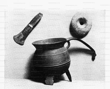
The third photograph herewith illustrates the following relics:—A mediaeval bronze skillet found near Langrigg during the construction of the Maryport and Carlisle Railway (completed 1845); a bronze paistave found by the late Mr. Jas. Cape at Seaton, probably 45 to 50 years ago; and a stone net-sinker, found by the late Mr. Jon. Mason at Seaton, about 25 years ago.
[These three articles have been offered by the writer as loans to the Carlisle Museum, where they can be seen.]
Cumbria and Westmorland Antiquarian and Archaeological Society. DEAN TRENCHES
During the Society's excursion to West Cumberland on July 4th, 1924, a visit was paid to Park Hill, Dean. This hill has the reputation locally of being the site of a Roman fort, but there is absolutely no foundation for this supposition, nor does it appear to have been a fort of any kind.
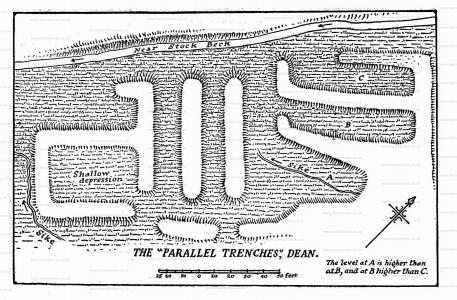
At the foot of the slope are the parallel trenches referred to by the late Mr. W. Dickinson (Trans. o.s. iii. 345). They are parallel excavations (see accompanying plan) but for what purpose they were constructed remains an enigma. They appear to be much later than the British period, and it has been suggested that they may have been medieval fish-ponds. Their water-logged condition and proximity to the old church and manor house give .colour to this view, but the theory is not completely convincing.
At the visit of the Society, Miss A. G. Gilchrist suggested that they had been osier-beds; and although osier-beds have not been noticed in the neighbourhood, the remark is worth consideration. At any rate the plan and view now offered may provide a record and material for discussion.
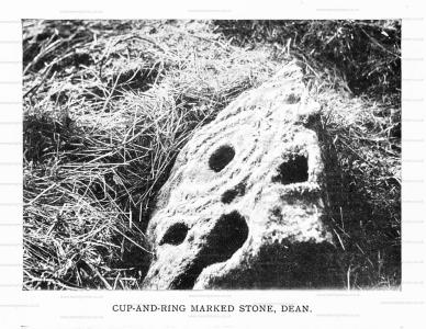
In the same field are the so-called archery butts, and near at hand was found the cup-and-ring-marked stone illustrated in these Transactions N.S. xxiii. 34.
Victorian Books, Cumberland and Westmorland Antiquarian and Archaeological Society, CWAAS Transactions 1923 Volume 23 Article IV
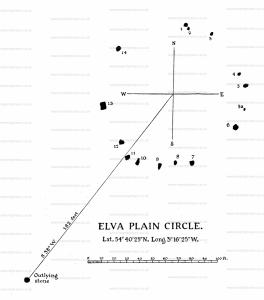
ARTICLE IV. Elva Stone Circle [Map]. By W. D. ANDERSON. Read at Carlisle, April 6th, 1922. This Circle is situated 1½ mile due W. of the N. end of 1 Bassenthwaite Lake. It stands about 470 feet abovethe sea level, on a plateau called Elva Plain, S.E. of Elva Hill.
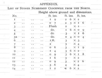
At present the Circle consists of 15 stones and an outlier, whose positions are indicated on the plan and their apparent dimensions on a separate table (pp. 32, 33). In 1913 the stone marked "5a" was covered by turf, but it has since come into view. This would suggest that there may be others out of sight. Four of the stones are flush with the ground and four others are less than 1 ft. above the surface. It seems probable that these eight stones have sunk, but to determine this point, perhaps some excavation might be necessary.
Stone io presents a great many markings, and in 1913 I thought that some might have been the work of man. Since then, however, a careful examination of a large number of stones, marked undoubtedly by natural agencies, has convinced me that none of the marks on this stone are of human origin.
No astronomical significance has, as far as I know, been attached to the position of the stones. Like the Circles at Castlerigg [Map] (Keswick), Long Meg [Map] and others, Elva has an outlier situated to the S.W., and like these it is in the immediate vicinity of a farmhouse supplied with good spring water, a point I shall refer to later. At Castlerigg [Map] a line drawn from the outlier through the centre of the Circle gives an alignment through Long Meg [Map] to the summit of Fiend's Fell, suggesting not so much an interrelation between the two Circles as that to both Fiend's Fell was a common object of observation. We know that at the beginning of May the Beltane fires were lighted on mountain tops. From Castlerigg [Map] the sun is seen rising over Fiend's Fell on May 1st and 2nd1, and my suggestion is that on this fell a Beltane fire was made in honour of the Earth god, Beal or Bile. With the advent of Christianity, Beal was officially abolished, but the missionaries, knowing that he still lived in the hearts of the people, compromised by allowing him to continue as a fiend.
Note 1. See the paper on Castlerigg Circle, these Transactions, N.S. xv., p. 111.
As a possible origin of the word Elva, Prof. Sedgefield gives the hypothetical Old Norse personal noun, "Elfr," (Place Names of C. and W., p. 47), but it seems simpler and quite as logical to take the word at its face value, Elfhow in 1488, and to suppose it an anti-pagan substitute for the name of some heathen divinity.
At Innerleithen, in Peebleshire, a custom, whose origin is lost in antiquity, occurs yearly in August. A procession climbs a neighbouring hill, called Caerlee (Caerleu?, the Fort of Lugh, the Celtic sun-god), where an effigy of Satan, nicknamed "Cleikie," is ceremonially burnt. Lugh's feast, Lugunasd, it will be remembered, was in August. Here there seems to be a transmutation to a definite personality, Cleikie, instead of an indefinite fiend or elf.
Like most of the larger Circles in this district, Elva has been designed with a 50 ft. radius. As has been remarked before (these Trans., N.S., XV., 101), this may some day throw light on the subject of the original builders. In the meantime, the question seems to be whether thèse Circles were built mostly by the Mediterranean race which spread from N. Africa over Europe as Neolithic man, or by their successors, the broad-headed people who brought bronze to Britain, and are known to have used circles for sepulture. These, according to Rice Holmes (Ancient Britain, etc., 424-425), were typical members of the Alpine race. They came from central Asia, and spreading through Asia Minor, crossed the Dardanelles and followed the great forest zone of Europe to the plains of France, whence some of them migrated to Britain, probably about 1800 B.C. It is not known that any of this race: crossed to Africa, yet numerous Circles are to be found in Algeria and Tunis. This is in favour of the Mediterranean race having been Circle builders, though it does not, of course, preclude the possibility of the Alpine race and even the Celts having constructed monuments of this kind.
The traditional, and commonly accepted view that some, at least, of the Circles were temples for religious rites, seems not unreasonable, especially as the stone Circles or Gilgals of Palestine, after they were taken over by the Israelites, were so used (Hosea xii., 11; Amos Iv., 4; I. Sam., xv., and many other passages). Moreover, as I mentioned before, hard by the Circles of this district reliable wells are to be found, now supplying water to farm buildings. This does not apply to such Circles as those on Moor Divock, which were only burying places, but Long Meg [Map], Gunnerkeld [Map], Castlerigg [Map], Elva and Swinside [Map] have each a good well of spring water in their immediate vicinity. It seems to me likely that in choosing the sites for all these larger Circles, the builders had in view the requirements of a resident community, which may have been simply a village settlement, or on the other hand, a society of tribal magi. The latter conjecture seems the more probable, when we consider the historical evidence to which reference has already been made.
The minor Circles, burial places of the bronze age, as shown by the relics found in them, were often near villages of people of their day; but, unlike the larger Circles, they do not appear to have had any close association with springs of pure water. It is possible that these springs were sacred, and had a religious as well as gn economic value for neolithic man.
