Transactions of the Cumberland and Westmorland Antiquarian and Archaeological Society Volume 40 Pages 169 to 206
Transactions of the Cumberland and Westmorland Antiquarian and Archaeological Society Volume 40 Pages 169 to 206 is in Transactions of the Cumberland and Westmorland Antiquarian and Archaeological Society Volume 40.
ART. XII. - King Arthur's Round Table. Final Report, including the Excavations of 1939, with an appendix on the Little Round Table1. By DR. GERHARD BERSU, Hon. F.S.A.
Note 1. Translated by Ian A. Richmond.
IN 1938 Professor R. G. Collingwood produced, in these Transactions (xxxviii, 1-31), an Interim Report on the excavations of 1937 at King Arthur's Round Table. Illness prevented him from completing the task, and the final investigation was conducted by the writer, to whom it had been entrusted, between 10th July and 27th August, 1939. Eight workmen were employed throughout, while the experienced Mr. W. Cruddas of Greenhead acted again as foreman. Mrs. Spence undertook the task of Excavations Secretary and Guide, and superintended the filling-in during the anxious days preceeding the outbreak of war. Dr. J. E. Spence devoted the first week of his vacation to joint direction, while Miss M. Cross and Miss K. S. Hodgson gave voluntary help in the more delicate tasks. It was particularly useful to have Mrs. Collingwood's presence for a week during the excavation. Mr. Hay and Dr. Goodchild gave much valuable advice on geological problems. Mr. R. Morton Rigg, as during the first season, undertook the organisation of labour and tools most generously lent by the Penrith Urban District Council. Captain Anthony Lowther, on behalf of Lowther Estates Limited, kindly extended permission to excavate, with the consent of the tenant, Mr. W. Bainbridge of the Home Farm; while H.M. Office of Works authorised excavation of a scheduled monument, a visit being paid by Inspector P. K. Baillie-Reynolds. To all these helpers and to Major Porter, I offer heartiest thanks for their assistance. Among many visitors I had the pleasure of welcoming Messrs. Grahame Clark and J. F. Grimes. Finally three trenches were made through the so-called Little Round Table (see Appendix) and, in co-operation with H.M. Office of Works, the surviving standing-stone in the adjacent circle at Mayburgh [Map] was secured against collapse.
Books, Modern Era, Sussex Record Society 1903, Transactions of the Cumberland and Westmorland Antiquarian and Archaeological Society Volume 40 Pages 169 to 206, The Site
(Position: Long. 2° 45' 30". Lat. 54°39' 50")
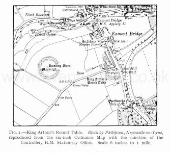
The monument, visible from the London-Carlisle Road and thus well-known to any of its users, lies in the parish of Yanwath and Eamont Bridge1. It is a mile and a half south-south-east of Penrith, and exactly a quarter of a mile south of Eamont Bridge, in the angle of the Carlisle Road and the by-road from Eamont Bridge to Tirril and Pooley Bridge (fig. 1, p. 206 from 6-inch scale Ordnance Map, edn. 1920, Westmorland III S.W. and S.E.). It stands on the western shelf of the flat 400-foot terrace of the rivers Lowther and Eamont. The slope which rises from the terrace on the west, enables a good general view of the monument to be obtained (Pl. E, i).
Note 1. Anc. Mon. Comm. Westmorland, London, 1936, p. 252, with a small plan and a view, here used as plate E, 1, through the kindness of Mr. Clapham, secretary to the Commission.
Figure 1. King Arthur's Round Table. Block by Philipson, Newcastle-on-Tyne, reproduced from the six-inch Ordnance Map with the sanction of the Controller, H.M. Stationery Office. Scale 6 inches to i mile.

Books, Modern Era, Sussex Record Society 1903, Transactions of the Cumberland and Westmorland Antiquarian and Archaeological Society Volume 40 Pages 169 to 206, The Actual State
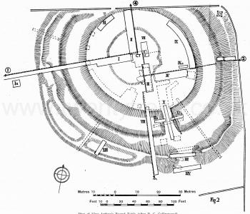
As we may gather from the new plan (fig. 2) by Professor Collingwood, which we have adopted as it stands, the monument consists of (I) a mound with gateway-opening to south; (2) a broad-bottomed encircling ditch with causeway, not aligned upon the gap in the bank; (3) a level platform enclosed by the ditch, on which lies, out of centre, (4) a low flat mound, the so-called disc. The Tirril Road, described above, has cut off bank and ditch to north as far as the central platform, while the Carlisle Road has sliced away part of the bank to east. Professor Collingwood describes the actual state in detail as follows:-
"The central platform is in shape nearer to an ellipse than to a circle. A tolerable approximation to its outline can be constructed by drawing an ellipse with the foci 100 feet apart whose major axis measures 172 feet and its minor axis 145. The intersection of those two axes I shall call the "centre" of the platform. The major axis bears roughly E.S.E.; to be precise, 114° (true). The line joining the centres of the causeways where they spring from the central platform (the position of the northern causeway being conjectural) bears 141° or roughly S.E These two bearings thus differ by 25°. The central line of the existing causeway is not easy to determine, but it bears about 160°, roughly S.S.E. This line does not pass through the gap in the mound which is meant to be opposite to it, but through the slope of the mound west of that. Placed eccentrically on the central platform is a raised disc, 75 feet in diameter and about eight inches above the general level of the platform.
Figure 2. Plan of King Arthur's Round Table (after R. G. Collingwood).

The only feature which is at all regular is the ditch. This is uniformly about 40 feet wide (it never shrinks to below 40 nor expands to above 43) and is, to its present bottom, between four and five feet deep. This bottom is flat and about 20 feet wide. The two sides differ in appearance. The outer side slopes comparatively gently, the angles at top and bottom being smooth and rounded as one would expect in prehisforic earthworks. The inner side is comparatively steep and its angles are sharp, especially that of the top. The form of this angle has long been a cause of perplexity to careful observers. The sides of the causeway show in this respect the same features as the inner side of the ditch.
The bank in its present form is very irregular. On either side of the south entrance it is from six to seven feet high and from 35 to 40 feet broad, and is separated from the ditch by a berm of some twelve to twenty feet. Elsewhere it does not rise to a height of more than four feet. All along the north side it has been completely destroyed; all along the east it has been seriously encroached upon by the London-Carlisle-Road; for about 200 feet on the south and south-west it has been mutilated by robbing material from it for making two long narrow enclosures against its outside. But this does not exhaust the tale of mutilations. From the north-east corner of the site, travelling clockwise, there is no berm at all for the first 180 feet. The bank, which is very low and has been encroached upon from the outside by the road, sinks on the inside evenly and gently to the lip of the ditch. Then comes a sudden change, and for the next 80 feet the bank is high and there is a well marked berm. Careful study of the inner side of the bank near its summit shows that it has here been robbed; the turf is dimpled by hollows which have evidently been made by quarrying. Beyond the entrance the same features are at first to be seen; then, as the berm narrows, the marks of quarrying in the inner side of the bank die away."
Books, Modern Era, Sussex Record Society 1903, Transactions of the Cumberland and Westmorland Antiquarian and Archaeological Society Volume 40 Pages 169 to 206, The Excavation
We began our excavation with section I, three metres wide, running from the centre of the disc on the central platform to the edge of the work. When certain facts appeared which could not be reconciled with the results of 1937, seeing that I had at my disposal only Professor Collingwood's printed report of 1937, it seemed desirable to make first a general survey of the geological formation of the site. For this purpose section I was extended across the sloping terrace to the field boundary on the west. The central platform was next further examined by sections II, III and IV. There then emerged such fundamental differences in respect of the hypotheses advanced in the preliminary report, as to necessitate a completely fresh examination linked with the excavation of 1937. A further section, VIII, was cut through the mound, and sections V and XIII elucidated still more details of its construction. Sections X, XI, XII and XIV examined the causeway and gateway-opening. Finally, in section VII, the so-called "cremation-trench," which Professor Collingwood had been unable to examine completely, was uncovered once more. Several short sections were cut (Id, XV, XVI; not shown on fig. 2) where surface indications of human activity were visible close by the monument. It appeared that we were here dealing with very recent diggings associated with mortar, bricks and broken crockery, evidently buried rubbish; and we go no further into the matter. The examination of King Arthur's Round Table may be considered as thus brought to a close.
Books, Modern Era, Sussex Record Society 1903, Transactions of the Cumberland and Westmorland Antiquarian and Archaeological Society Volume 40 Pages 169 to 206, Results of the Excavation
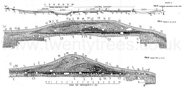
The Geology. Sections I, III, IV and V crossing the site from west to east (Pl. A, fig. 3) and Sections VIII, III, VII and II, from south to north (Pl. B, fig. 6), give between them a clear general picture of the natural formation. The different kinds of natural soil are shown with corresponding conventions in each diagram, while soil which has been subject to human activity is left white.
Plate A Figures 3, 4 and 5.

We may first consider the east-to-west section (PL A, fig. 3). The basic formation is a heavy red boulder clay (A), which comes to the surface on the slopes west of the monument. This boulder clay occurs, horizontally bedded, at the bottom of the ditch both on the west and on the east (sections I and V) . Between the west ends of sections I and Ia there commences, on top of the boulder clay, coarse greenish gravel drift (B) containing large boulders, sandy deposits, and an occasional fraction of worked red boulder clay. There is distinct demarcation between gravel and boulder clay. Where the edge of the gravel B is in contact with the impermeable boulder-clay A it is darkened by xidisation for some 10-15 centimetres. Similarly, the topmost Io centimetres of boulder clay is a deeper brown when in contact with B. Gravel B extends, in similar formation, right across the site to the east. To west, there develops beyond the bank, so as gradually to cover the top layer of the gravel, a yellow loamy soil (C) . It contains boulders of all sizes, with occasional belts of gravel and sand. The line between gravel B and this material C is undulating. The material C itself, which dries into a solid mass on exposure to air, is locally called "sammel." Mr. S. E. Hollingworth, of the Geological Survey and the National Museum of Geology, London, kindly furnished the following report on a sample:-
"The sample is a pale stone-coloured stony loam. The stony fraction contains pebbles up to 4 inch in length and consists almost entirely of lavas, presumably derived from the adjacent Borrowdale Volcanic Series to the west. Only one different fragment-a piece of Skiddaw Slate-was noticed out of 30 examined. The finer material shows little or no trace of grading, but the paucity or absence of clay fraction is noteworthy. Test failed to reveal any trace of calcium carbonate in the finer fraction and the rarity of quartz sand grains derived from Penrith or St. Bees Sandstones is interesting as confirming the dominantly western origin of the deposit. The finer material seems to be entirely derived from pre-Carboniferous rocks. The unsorted character and general appearance of the sample is suggestive of a sandy boulder clay-possibly a decalcified one. Locally boulder clays do consist almost wholly of Borrowdale debris and are in places quite sandy. The non-calcareous character, absence of clay fraction and lack of sorting are not, however, inconsistent with deposition by water as a downwash from neighbouring higher ground, possibly a late glacial effect. The texture resembles that of some brick-earths. I do not feel able to express a definite opinion as to which is the more probable origin from consideration of a sample without regard to field relations."
Where covered by the west bank the "sammel" retains its ancient surface (E), as when the bank was raised. It is then cut by the ditch to east and continues, at the same level and in similar relation to the gravel, across the central platform as far as the end of section IV. Then it gets steadily thinner and peters out completely in Section IX, at the east lip of the platform. In the middle of section IV there emerges fairly sharply from the subsoil a belt of fine red sand (D) covering gravel B. This then forms the eastward horizontal boundary between the gravel B and "sammel" C. Eastward beyond the ditch, however, only this sandy belt D, and no "sammel" C, is preserved on top of the gravel. On the surface of the central platform the "sammel" exhibits various signs of weathering, in the shape of very fine-grained clay, resembling loess, which lies in shallow troughs on its surface in thin deposits up to 10 centimetres thick (Pl. D, fig. 13, p. 191).
Continues ....
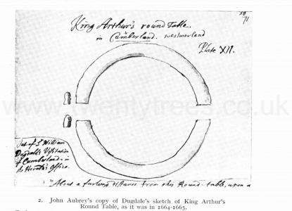
Plate E. John Aubrey's copy of Dugdale's sketch of King Arthur's Round Table. The notre reads "Out of William Digdale's Visitation of Cumberland in Herald's Office.
