Wessex from the Air Plates 39 and 40
Wessex from the Air Plates 39 and 40 is in Wessex from the Air.
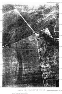
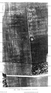
The Stonehenge Avenue [Map].

28 May 1928. Reference Nos. 15. and 17. County. Wilts. 54 SE. (122; D. 6). Parish. Amesbury. Latitude. 51° 10' 53" N. Longitude. 1° 48' 46" W. Height above Sea-level. About 300 ft. (91 metres). Geological Formation. Upper Chalk. Time and Date of Photograph. 10.9 a.m., 28th May. Height of Aeroplane. 2,500 ft. (762 metres). Speed of Shutter. 1/180th of a second.
The history of the rediscovery of the Stonehenge Avenue has already been published in the Observer and in Air Survey and Archaeology, together with a bibliography of the recent literature of Stonehenge. The present account assumes a knowledge of the main facts there related. The photographs here reproduced, however, are new, and bring out very clearly the course of the avenue where it runs nearly due east and west. Its double line is seen crossing Plate XXXIX; a glance reveals the continuity of the upper part, where it is on virgin down, with the lower, where it enters a large cornfield. The upper part can be traced continuously and without a single break right up to Stonehenge itself; in the top left-hand corner of Plate XXXIX it can just be seen as it begins to curve gently away to the left.

Across Plate XL its course can be followed as far as the fieldroad between the two King Barrow copses. Beyond this, owing to the nature of the crops growing there in 1924, it cannot be traced on this photograph; nor was it visible from the air beyond this point in 1924, though photographs taken in earlier years by the Royal Air Force (reproduced in Air Survey and Archaeology) show its course quite clearly both here and beyond, as far as the Amesbury Road.

In the field to the right will be seen a large white spot surrounded by a darker band. It is a round barrow [Amesbury Barrow 27 G41 [Map]], opened by Sir Richard Colt Hoare. It had, he states, been opened before. It contained the skeletons of two adults and two children. Round the arm of one of the adults was the broad bronze bracelet here illustrated, now in the Devizes Museum. (See Ancient Wiltshire, i. 160, Amesbury, Barrow 27; Stourhead Catalogue, no. 160, p. 42; Archaeologia, xliii. 469, fig. 172; Evans, Anc. Bronze Implements, fig. 480.) Goddard’s reference number is ‘Amesbury 41’ (W.A.M. xxxviii. 168).
Above and to the right of the barrow are many circular rings and blobs, probably representing ploughed-out barrows. The sites might repay excavation, since the cists, dug below the surface level, might still be intact.
O.G.S. Crawford.