Iron Age Hill Forts Dorset
Iron Age Hill Forts Dorset is in Iron Age Hill Forts.
Europe, British Isles, South-West England, Dorset, Buzbury Rings [Map]![]()
Buzbury Rings [Map] is an Iron Age Hill Fort in Dorset.
Europe, British Isles, South-West England, Dorset, Child Okeford, Hambledon Hill [Map]![]()
Europe, British Isles, South-West England, Dorset, Durweston, Hod Hill [Map]![]()
Around 500BC. Hod Hill [Map] is an Iron Age Hill Fort in Dorset that was occupied by the Durotriges. Radiocarbon analysis suggests a date of 500 BC for the main rampart.
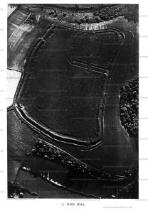
Wessex from the Air Plate 1. Hod Hill [Map].

Europe, British Isles, South-West England, Dorset, Durweston, Hod Hill, Lydsbury Rings [Map]![]()
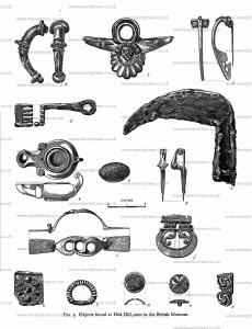
Wessex from the Air Plate 1. After reading the foregoing description of what was to be seen within the area of this small Roman camp, it is very disappointing to turn to the plan that was taken in 1858 (Hutchins, p. 307). The area is a mere blank! Hutchins gives some account of numerous relics that have been dug up from time to time within the area of the camp on Hod Hill. They were in Mr. Durden's collection at Blandford, but are now in the British Museum. Roach Smith (Collectanea Antiqua, vol. vi) says of them "These antiquities have been collected by Mr. Durden during a considerable number of years in the course of agricultural operations." From which it appears that there had not up to then been any systematic excavation at Hod Hill. The iron weapons found point to occupation during the later portion of the prehistoric Iron Age. The Roman camp, or Lydsbury Rings [Map], as it is called, yielded a number of Roman relics, turned up apparently by the plough. The coins found give a very early date to the Roman occupation of this portion of Hod Hill.
Wessex from the Air Plate 1. The disappointing plan given in Hutchins's History of Dorset was "taken in 1858, just as the workmen were paring the turf preparatory to cropping the western portion of the area, and prior to the ancient traces being obliterated" Lydsbury Rings [Map] had not then been disturbed, but its area was subsequently ploughed over. In the preface to Dorsetshire: Its Vestiges, Celtic, Roman, Saxon, and Danish, by Charles Warne, 1865, he says: "Thus, and that very recently, the Roman Castrum within the Celtic camp and Oppidum on Hod Hill has, to the lasting disgrace of those concerned, been ruthlessly destroyed; the plough has passed over its Praetorium, and the site once occupied by the surrounding host, with all its details so well defined, is now no longer to be traced; thus an example of Roman castrametation "the finest of its kind, in fact unique, has been obliterated, and that without a voice being raised or an effort made to stay the hand of the despoilers."
'Accordingly, from these two extracts we may assume that the whole of the area of the Roman camp and part of that of the outer camp have been ploughed over.' The actual area once ploughed can clearly be seen on the air-photograph. It occupies about half the total area of the outer camp; the straight furrow-lines can still be distinguished, giving to the western portion a texture or graining quite different from that given by the unploughed turf of the eastern half.

Wessex from the Air Plate 1. THE ROMAN CAMP [Map]
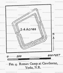
Mr. Sumner then describes the smaller enclosure in the north-western corner, which has been proved, both by its castrametation and contents, to be a Roman camp of the first or early second century. The camp was formed by cutting off a corner of the bigger one; and it has therefore only two 'Roman' sides. Otherwise, both in size and appearance, it closely resembles the westernmost (D) of the Agricolan camps at Cawthorne, Yorkshire (see Fig. 4). Mr. Sumner calls to our notice the resemblance in execution between this camp and Soldier's Ring (Plate XLIX). Both have the characteristic neatness and precision of Roman earth-work.

Spetisbury Rings aka Crawford Castle![]()
Spetisbury Rings aka Crawford Castle [Map] is an Iron Age Hill Fort in Dorset overlooking the River Stour.
Weatherby Castle, Dorset![]()
Weatherby Castle, Dorset [Map] is an Iron Age Hil Fort.
The monument includes Weatherby Castle, a small multivallate hillfort which occupies a prominent position at the higher southern end of a chalk spur. The hillfort has two roughly concentric ramparts and ditches, separated by a gap of up to 27m enclosing an irregular sub-rectangular area of about 7ha, on the highest part of the hill. The inner enclosure covers an area of about 2.5ha and is defined by a rampart, up to 25m wide, up to 2.5m high from the interior and about 6m high externally. The external ditch is about 12m wide and 1.5m deep with a discontinuous counterscarp bank, up to 8m wide and 0.6m high. The outer rampart, where best preserved, is up to 25m wide, 2m high from the interior and up to 9m high from the outside, although for much of its length it has been reduced on the interior, presumably by past cultivation, to an outward facing scarp. An external ditch, with a counterscarp bank, noted by Hutchins in the 18th century, is no longer clearly visible on the surface but will survive as a buried feature up to 20m wide. The original entrance on the western side of the hillfort has also been disturbed. The inner ramparts curve outwards creating a narrow passage 12m wide, approached from the outside by a ramp. There is a corresponding gap in the outer bank which is protected by a third bank covering the gap, now an outward facing scarp 125m long and up to 3m high. A gap in the inner rampart to the north of this is not original. There is a low bank, 2.5m wide and 0.4m high, running around the inside of the hillfort, adjacent to the rampart. This is of unknown date and may be a plantation enclosure. The domed interior shows no visible signs of occupation features although they may be masked by the vegetation. Within the enclosure there is a brick built obelisk with a stone inscribed `EMP 1761', probably referring to the owner at the time, Edmund Morton Pleydell. This is a Listed Building Grade II. All fence posts and the obelisk are excluded from the scheduling although the ground beneath these features is included.