Orkney Chambered Cairns Unspecified Type
Orkney Chambered Cairns Unspecified Type is in Orkney Chambered Cairns.
Unstan Chambered Cairn [Map] is a Neolthic Chambered Tomb located near Stromness.
Europe, British Isles, Scotland, Orkney Islands, Orkney Southern Islands, South Ronaldsay, Banks Chambered Cairn [Map]![]()
3000BC. Banks Chambered Cairn [Map], aka the Tomb of the Otters, was found in Sep 2010. The tomb is quarried out of solid bedrock. It has six chambers. Approximately 2000 human bones were excavated from one of the chambers including adults, children and babies. More recent excavations of the entrance and passageway in March 2012 revealed another 1000 human bones. Recent carbon dating shows the very last bones to be deposited in the passageway in 3021 BC.
Europe, British Isles, Scotland, Orkney Islands, Orkney, Ness of Brodgar, Brookan Chambered Cairn [Map]![]()
Brookan Chambered Cairn [Map]. With an approximate diameter of 16 metres (52.5ft), it was first investigated in 1861, when it caught the eye of the antiquarian James Farrer. In 1861, the mound survived to a height of 1.8 metres (6ft) and had a diameter of around 13 metres (44ft). Cutting into it, the excavators encountered a low, encircling stone wall at the base, circa 0.30m (1ft) high. In 1861, the mound survived to a height of 1.8 metres (6ft) and had a diameter of around 13 metres (44ft). Cutting into it, the excavators encountered a low, encircling stone wall at the base, circa 0.30m (1ft) high.
Archaeological Journal Volume 20 Section III. In the beginning of July, 1861, Mr. Farrer sent a few of the labourers who had begun excavations in Maes-how in Stenness, to open a barrow [Brookan Chambered Cairn [Map]] at the edge of the very large ancient quarry near Bookan, in the adjoining parish of Sandwick, and not far from the large circle of standing stones of Brogar. The barrow was about 44 feet in diameter, and about 6 feet high, when opened; but it had been partially examined on some former occasion, and the upper part was consequently in a ruinous state. On cutting into the mound, a circular wall or facing, about a foot in height, similar to that which encircles the so-called Picts'-houses, was found, about 11 feet within the edge of the base of the barrow. A low passage, 6¼ feet in length, and 21 inches in width and height, extended from the outer surface of the wall on the south side of the barrow to a small chamber or kist, 7 feet 1 inch long and 4 feet wide, formed by large flagstones set on edge. At the north end of this was another kist, 4 feet 8 inches long, and 3 feet 1 inch wide. On the east side was a similar kist, 4 feet 8 inches long, and 2 feet 9 inches wide, and on the west side were two similar kists, each of which was the same length as the eastern kist, and both were 3 feet 1 inch wide. All the kists were about 2 feet 8 in. deep. A flint lance-head and some pieces of small clay vessels or urns lay at the north end of the central kist, but no bones were found in it. Remains of human skeletons, greatly decayed, lay in the surrounding kists. A glance was sufficient to show how nearly akin the Bookan barrow is to the so-called Picts'-houses. It has, in common with them, the encircling wall or facing, the passage from the outside to the interior, and the central chamber or kist, surrounded by others—in fact, all the characteristics of a Picts'-house, with the exception of the converging walls, which alone were wanting to complete the resemblance. And this point of difference may partly be owing to the facility with which the flagstones that form the kists could be obtained from the neighbouring quarry, and possibly also to the social position of the person interred, whose rank may not have been deemed sufficient to call for the erection of a more elaborate structure.
Europe, British Isles, Scotland, Orkney Islands, Orkney Northern Islands, Calf of Eday Chambered Cairns [Map]![]()
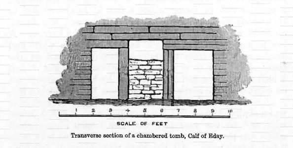
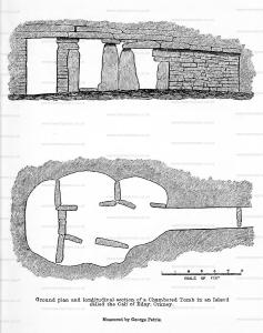
Archaeological Journal Volume 20 Section III. In the Calf of Eday, a small island, now uninhabited, there is what I consider another variety of the chambered tombs [Calf of Eday Chambered Cairns [Map]]. It is wholly subterranean, situated in the face of a slope, and it consists of a central chamber with four surrounding cells, formed by upright flagstones, with the usual passage from the outside to the interior. (See the accompanying ground-plan and section.) Beneath the outer extremity of the passage or entrance, a drain was discovered, indicated in the plan, and was traced some distance down the hill-side. The plan will show how closely the building resembles in its internal arrangements, not only the Bookan barrow, but also the so-called Picts'-houses. The same structural design evidently pervades the whole.
The interior measurement, from the extremity of the entrance passage, where the transverse drain above mentioned is indicated in the ground-plan, is 16 ft. 6 in. by about 6 ft. 6 in. in width across the middle of the building. The width of the passage is 1 ft. 8 in.; its height, 3 ft.; the opening to the central cell, 2 ft. 4 in; the largest of the lateral cells measures about 4 ft. 6 in. by 2 ft. 6 in.; the innermost cell measures 6 ft. 2 in. bj 2 ft. 6 in., and in height 4 ft. 6 in. The central cell measures only 4 ft. in height.


Europe, British Isles, Scotland, Orkney Islands, Orkney Northern Islands, Holm of Papa Westray Chambered Cairn South [Map]![]()
3000BC. Holm of Papa Westray Chambered Cairn South [Map] has a number of unusual elements including the large central chamber and two 'double' side cells. It's also home to a diverse collection of Neolithic artwork. The tomb was excavated in 1849.
Archaeological Journal Volume 20 Section III. Having repeatedly and carefully examined the large Picts'-house on the Holm of Papa-Westrey [Map], which has been described by Captain Thomas, R.N., in the Archaeologia1, I discovered numerous incised marks on the walls: some of them are here figured. The markings a. (see woodcuts) occur with some others, very obscure in character, on the east side of the large chamber; those represented in the woodcut b. are on the lintel over the entrance to one of the cells. These resemble incised figures in the chambered cairns at Newgrange and Dowth in Ireland, on the rocks in Scania, and in chambered tombs at Carnac in Brittany.
Note 1. Archaeologia, vol. xxxiv., p. 127.

Europe, British Isles, Scotland, Orkney Islands, Orkney Northern Islands, Westray, Pierowall Quarry Chambered Cairn [Map]![]()
Europe, British Isles, Scotland, Orkney Islands, Orkney Northern Islands, Westray, Pierowall Quarry Chambered Cairn Carbon Dates
Carbon Date. 2310BC. Early Bronze Age Carbon Dates
Report: Bone, id as Martes martes, pine martin, PQ81, from lower levels of stone cairn at Pierowall Quarry, Westray, Orkney Isles, off Scotland. Subm J Clutton-Brock & M J Armour-Chelu. Comment (subm MJA-C): date slightly earlier than two conventional radiocarbon dates from site; excavator is satisfied that date is within use period of cairn. [Ed: NGR not given, estim from gazetteer.]
ID: 6689, C14 ID: OxA-1049 Date BP: 4310 +/- 80, Start Date BP: 4230, End BP: 4390
OS Letter: HY, OS East: 438, OS North: 488
Archaeologist Name: N Sharples
Reference Name: Archaeometry, 29, 1987, 300; Proc Soc Antiq Scot, 114, 1984.
Council for British Archaeology (2012) Archaeological Site Index to Radiocarbon Dates from Great Britain and Ireland [data-set]. York: Archaeology Data Service [distributor] https://doi.org/10.5284/1017767
Creswell Crags
Derbyshire
England. Subm R M Jacobi. Comment (subm): OxA-1471
-1615 and -1937 are all for single bones of Bos primigenius; they are linked by a common preservation state and can
Carbon Date. 2140BC. Early Bronze Age Carbon Dates
Report: Bone, id as Bos, from material used in construction of structure beside ruined chambered tomb at Pierowall Quarry, Westray, Orkney, Scotland. [Ed: one text gives lab. no. incorrectly as GU-1382]
ID: 3216, C14 ID: GU-1582 Date BP: 4140 +/- 60, Start Date BP: 4080, End BP: 4200
Abstract: Occupation beside ruined cairn
Archaeologist Name: N Sharples
Reference Name: Proc Soc Antiq Scot, 114, 1984, 75-125 esp 90; Renfrew C (ed), 'The prehistory of Orkney', 1985, 272
Council for British Archaeology (2012) Archaeological Site Index to Radiocarbon Dates from Great Britain and Ireland [data-set]. York: Archaeology Data Service [distributor] https://doi.org/10.5284/1017767
Carbon Date. 2140BC. Early Bronze Age Carbon Dates
Report: Bone, id as Bos, from secondary occupation of structure beside ruined chambered tomb at Pierowall Quarry, Westray, Orkney, Scotland. [Ed: one text gives lab. no. incorrectly as GU-1383.]
ID: 3217, C14 ID: GU-1583 Date BP: 4140 +/- 60, Start Date BP: 4080, End BP: 4200
Abstract: Occupation beside ruined cairn
Archaeologist Name: N Sharples
Reference Name: Proc Soc Antiq Scot, 114, 1984, 75-125 esp 90; Renfrew C (ed), 'The prehistory of Orkney', 1985, 272
Council for British Archaeology (2012) Archaeological Site Index to Radiocarbon Dates from Great Britain and Ireland [data-set]. York: Archaeology Data Service [distributor] https://doi.org/10.5284/1017767
Carbon Date. 2030BC. Early Bronze Age Carbon Dates
Report: Bone, id as Bos, from secondary occupation of structure beside ruined chambered tomb at Pierowall Quarry, Westray, Orkney, Scotland. [Ed: one text gives lab. no. incorrectly as GU-1384.]
ID: 3218, C14 ID: GU-1584 Date BP: 4030 +/- 65, Start Date BP: 3965, End BP: 4095
Abstract: Occupation beside ruined cairn
Archaeologist Name: N Sharples
Reference Name: Proc Soc Antiq Scot, 114, 1984, 75-125 esp 90; Renfrew C (ed), 'The prehistory of Orkney', 1985, 272
Council for British Archaeology (2012) Archaeological Site Index to Radiocarbon Dates from Great Britain and Ireland [data-set]. York: Archaeology Data Service [distributor] https://doi.org/10.5284/1017767
Carbon Date. 510BC. Early Iron Age Carbon Dates
Report: Bone, id as Bos, from occupation layer immediately preceding construction of round house at Pierowall Quarry, Westray, Orkney, Scotland.
ID: 3214, C14 ID: GU-1580 Date BP: 2510 +/- 80, Start Date BP: 2430, End BP: 2590
OS Letter: HY, OS East: 438, OS North: 490
Archaeologist Name: N Sharples
Reference Name: Proc Soc Antiq Scot, 114, 1984, 75-125 esp 90; Proc Soc Antiq Scot, 121, 1991, 205; Renfrew C (ed), 'The prehistory of Orkney', 1985, 272
Council for British Archaeology (2012) Archaeological Site Index to Radiocarbon Dates from Great Britain and Ireland [data-set]. York: Archaeology Data Service [distributor] https://doi.org/10.5284/1017767
Carbon Date. 425BC. Middle Iron Age Carbon Dates
Report: Bone, id as Bos, from occupation layer contemporary with use of round house at Pierowall Quarry, Westray, Orkney, Scotland.
ID: 3215, C14 ID: GU-1581 Date BP: 2425 +/- 60, Start Date BP: 2365, End BP: 2485
OS Letter: HY, OS East: 438, OS North: 490
Archaeologist Name: N Sharples
Reference Name: Proc Soc Antiq Scot, 114, 1984, 75-125 esp 90; Proc Soc Antiq Scot, 121, 1991, 205; Renfrew C (ed), 'The prehistory of Orkney', 1985, 272
Council for British Archaeology (2012) Archaeological Site Index to Radiocarbon Dates from Great Britain and Ireland [data-set]. York: Archaeology Data Service [distributor] https://doi.org/10.5284/1017767
Europe, British Isles, Scotland, Orkney Islands, Orkney Northern Islands, Rousay, Taversoe Tuick [Map]![]()
Unstan Ware is finely decorated early Neolithic Pottery from the 4th Millenium BC and the 3rd Millenium BC; elegant shallow bowls with a groove-pattern around the rim, or undecorated round bottomed bowls. The name is from the Unstan Chambered Cairn [Map] where the pottery was first found in 1884. Unstan Ware is found in tombs: Midhowe Chambered Cairn [Map], Tomb of the Eagles [Map], Taversoe Tuick [Map] as well as farmsteads: Knap of Howar [Map].