Prehistoric Brittany Burials
Prehistoric Brittany Burials is in Prehistoric Brittany, Neolithic Burials.
Europe, France, Brittany, Morbihan, Gavrinis Burial Mound [Map]
Archaeologia Volume 32 Appendix. Further Notice of the Monument at Gaur' Innis [Map] in Britanny.
29th April, 1847 - William Bromet, Esq. M.D. F.S.A. in another Letter to the Director, communicated a further explanation of the Monument at Gaur' Innis in Britanny — together with some rubbings from those of its sculptured stones which he considered the most interesting. A remarkable peculiarity in this Monument consists in the interior faces of several of its component stones being engraved with concentric curves resembling eels or serpents: and others with those instruments called celts, or small ovals pointed at one end, but so placed as to give an appearance of their being hieroglyphic characters. There are only two other instances of the kind on record, viz. one formerly near Gavr' Innis called the "Pierres Plates now destroyed, and the one at New Grange, in Ireland. Another distinctive feature is a sort of staple made in the stone at about three feet from the ground, by three holes communicating with each other at the back, and indicating much friction by the internal smoothness, as if by the action of ropes passed through.
Europe, France, Brittany, Morbihan, Locmariaquer, Mané Lud Burial Mound [Map]
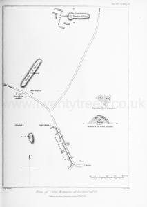
Archaeologia Volume 25 Section XIII. The accompanying plan (Plate XXV.) exhibits within a small area two long tumuli, each containing a Kistvaen; a small tumulus with a Kistvaen of unusual length; two cromlechs, one of them of singular beauty; and two obelisks, each carved out of a single stone, of which one measured upwards of 35 feet in length, the other 63!
1. The tumuli are clearly sepulchral from the evidence of the Kistvaens which they once covered. The two largest are called the mounds of Héleu, and of Cæsar. The small one is nameless, although it contains the longest Kistvaen.
The tumulus of Héleu [Mané Lud Burial Mound [Map]] is 100 feet broad, 300 feet long, and has an elevation of 30 feet. That of Cmsar is of the same elevation and breadth, but 400 feet in length. They are both composed of layers of earth and stones, separate and mixed. The section of Heleu given in the plan shows 26 feet of earth, overlaid by a coating three feet deep of earth and stones, surmounted by a covering of earth one foot in depth.
This tumulus is remarkable for its shape, which is very similar to that of the Temple of Carnac at Le Maenac; a campanular [bell shaped] head being added to the usual straight mound of parallel sides.
In this head is a Kistvaen of considerable dimensions; and particularly interesting, as being partly exposed and partly covered. It affords an example of the manner in which the Kistvaens were overlaid by tumuli. Two tabular stones cover the chamber. One is a parallelogram fifteen feet six inches by fourteen feet; the other, an irregular quadrangular figure with an acute angle pointed towards the entrance of the tomb. Its breadth at the base, where it meets the parallelogram, is fourteen feet nine inches; its breadth from the angle to the base, thirteen feet. The dolmen is supported in the usual manner upon massive props. The whole length of the Kistvaen is twenty-seven feet, the depth of the chamber six feet.
The other long tumulus, which has its Kistvaen in the centre, is ridiculously ascribed to Julius Caesar, whose only work (if it was indeed his) in the neighbourhood of Locmariaker, is a curious square embankment on the sea shore about a mile distant, round a marine marsh, appearing to have been made for the purpose of a dry dock. General de Penhouet, who discovered it, thinks it Roman; and it has every appearance of being so. The tumulus ef Caesar has been much disturbed, and its Kistvaen destroyed.

Europe, France, Brittany, Morbihan, Pierres Plats Chambered Tomb [Map]
Pierres Plats Chambered Tomb [Map]. Well-preserved Passage Tomb with multiple carvings.
Europe, France, Brittany, Morbihan, Locmariaquer, Table des Marchands [Map]
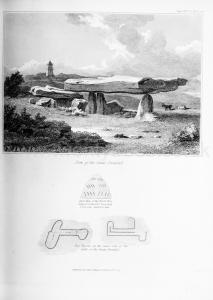
Archaeologia Volume 25 Section XIII. 2. But near it is the most beautiful cromlech [Table des Marchands [Map]] which I have ever seen; and I may add, the most interesting. The table stone, which is eighteen feet long, twelve feet wide, and four feet thick, is supported upon three props, on one of which it rests upon a very small point. It has the approach usually attached to the Kistvaens of Britany, consisting of an avenue of contiguous stones placed edge to edge, and covered in by three slabs of stones. The highest part of the table is about nine feet from the ground, the height of the approach is about four feet.
Although this monument is, strictly speaking, a cromlech, yet the ashes and a flint knife which have been discovered under it, together with the avenue of approach, prove it to have been sepulchral.
The beauty of this cromlech would of itself be sufficiently interesting; but, in addition to its elegance of figure, it presented to our admiration the only hieroglyphical characters which it was our fortune to see inscribed on a Celtic monument; unless I except a rude unmeaning or rather unintelligible scrawl upon one of the supporting stones of the Dolmen of Penab, which bears more resemblance to the human ear than to any other figure.
The extreme supporter of the table stone of the Cromlech of "Caesar" is -charged with remarkable curvilinear characters, regularly arranged in two columns, each containing three divisions of four lines each. Great care has been bestowed upon their execution, for they are not cut into the stone, but raised upon it. I cannot conceive what they were intended to represent.
The table also exhibits upon its under surface two hieroglyphical diagrams, similarly raised upon the stone, whose execution is admirable, though one of them is imperfect, from the pealing of the stone by frost.
I confess myself ignorant of the meaning of these hieroglyphics also, and leave their interpretation to more experienced antiquaries. One of them resembles, in some degree, the instrument called a Celt; the other is more like a key. But M. Mahé, who seems to have seen only the former (which was my case on my first visit, for the latter is more obscurely traced), called it an [Greek Text]. The conjecture is plausible, if the worship of the Phallus can be clearly proved against the Armoricans. That Asiatic and Egyptian ideas had, by some means or other penetrated into this country, is probable from several facts insisted on by M. de Penhouet. Thus, there is an artificially carved rock in the Morbihan which very closely resembles the god Anubis. Again, the Syrian deity Lilith, so celebrated in the mythology of the Jewish Rabbins, was once adored in the Morbihan. Her statue may be still seen in a perfect state at the chateau of Quinipili, near Baud, where it was placed upon a pedestal by a former owner of the domain. The only covering which the figure has is a cap with two flaps; and what is very remarkable, the head-dress of the female peasantry of the commune in which the statue stands, is precisely a copy of Lilith's cap, and worn in the same manner! For how many centuries that head-gear has been worn it is in vain to guess. Another peculiarity of dress, which savours of an oriental origin, is observable among the male peasants: they all wear a checked cloth, like the South-country plaid of Scotland, bound round the loins, and call it a "turban." My friend M. de Penhouet conjectures that, when the Asiatic colony (whoever they were) emigrated to Britany, they transferred the turban from the head to the loins, retaining the name, though they lost the original use of the garment. Still, however, I do not see sufficient evidence of the worship of the Phallus in Armorica, which must have prevailed, if the hieroglyphic on the cromlech is a representation of the [Greek Text].
Within another tomb at Locmariaker (now I believe destroyed), M. de Penhouet discovered, in 1813, several very interesting hieroglyphics, which he has engraved in his "Archeologie Armoricaine." The circle (single and concentric), the horseshoe, the branch of a tree, and the harp, are the symbols chiefly delineated. The first three are sometimes seen in conjunction with the horse and horse's head upon the coins of Armorica.
