Brecknockshire
Brecknockshire is in Section 2 Long Barrows.
6a Carn Goch![]()
Brecknockshire, 41 N.E. Parish of Llangattock. 6a*.
Latitude 51° 57' 08" Longitude 3° 08' 38". Height above O.D., between 270 & 300 feet.
The following account presumably refers to the site marked "Garn Goch" on the O.S. map:-
Some workmen recently engaged in clearing away a large heap of stones in Llangattock Park, the seat of his Grace the Duke of Beaufort, accidentally met with a cist or cromlech, consisting of four rude stones put up in the ground on their edges, while a fifth covers the top. On its being opened, a quantity of human bones were discovered, some of which soon crumbled to dust; but the bone of the arm and also the upper part of the jaw, part of the skull, and a row of teeth, were quite perfect, all of which were carefully collected and preserved. The size of the interior was 8 feet 6 inches long, 4 feet wide, reduced to 3 feet 10 inches at the other end, and 2 feet 2 inches high."
When I first visited the neighbourhood I heard indirectly that the rnonument in question was supposed not to be an antiquity and did not visit it. On August 17th, 1924 I visited it in company with Dr. Mortimer Wheeler, Director of the National Museum of Wales, and we agreed that the cairn was a long one of the same type as the other Brecknockshire examples. On the south-eastern side are the remnants of a large capstone, but for the rest it is impossible to make out any plan or order. In the wood close by on the east are a number of cairns which may be of natural origin.
Gentleman's Magazine, 1847, Pt. 2, p. 526 (quoted above).
3 Croesllechau![]()
Brecknockshire, 23 S.W. Parish of Bronllys. 3*.
Latitude 52° 01' 93". Longitude 3° 12' 49". Height above O.D., 400 feet.
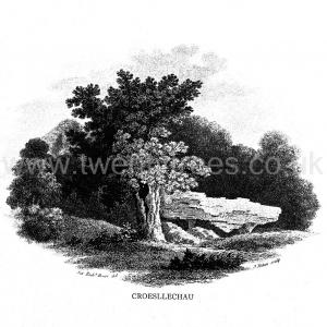
"In a field called Croeslechau about two miles eastward of this town or village [Talgarth] but in the parish of Bronllys and on a farm called Bryn-y-groes, is a cromlech, not merely interesting on account of its antiquity, but from the circumstance of a white thorn growing close, and indeed under part of it, which has gradually raised the horizontal or covering-stone several inches out of its original position ; it is therefore not only venerable as a relic of very ancient days but as a natural curiosity." So wrote Theophilus Jones in 1809, and put a drawing of the "cromlech" on his title-page. In 1832 (but not before) the site was marked on the engraved one-inch O.S. map, from which the co-ordinates given above have been taken. Now the site is unknown and all memory of it has completely vanished in the neighbourhood. Mr. Evan Morgan has visited the site and reports that no traces of the "cromlech" were visible ; nor were enquiries of the farmer at Bradwys any more successful in identifying the site. It is not unlikely that the monument was destroyed when a new road was made at some date probably very soon after 1832. It appears that Bryn-y-groes Farm was situated about 200 yards S.W. of Lower Barn, where a house stood about 80 to 100 years ago ; on the old MS. 2" map of 1814 the farm of Bryn-y-groes is marked close to where the site of Croesllechau is marked on the 1832 edition.
Theophilus Jones, Hist. of the County of Brecknock, VoL II. 1809, p, 338 (vignette on title-page, reproduced on opposite plate).
10a Cwm Fforest![]()
Brecknockshire, 29 S.W. Parish of Talgarth. 10 a*
Latitude 51° 57' 25". Longitude 3° ii' 20". Height above O.D., 900 feet.
This burial-chamber in a long mound was discovered on August 17th, 1924 by Dr. Mortimer Wheeler and myself. We made enquiries at Ty-isaf, since I had been told by Mr. Evan Morgan of Brecon that an undiscovered burial-chamber existed somewhere hereabouts. We were unable to locate it at first, though actually we passed within a few feet of it at one time. We were shown it by the occupier of Ty-isaf. The burial-chamber is hidden in a dense thicket of brambles and young saplings. It stands on the western edge of the steep valley of the Rhian-goll, the chamber being exposed at the south-east end of a mound. A capstone covers the south-eastern end, which is narrower than the rest, and may form a short passage to the chamber itself. The capstone is supported by dry walling which forms also the sides of the chamber proper. There are no upright slabs. There is a steep ditch or gulley parallel to the mound and immediately below it on the south-western side, and some of the stones of which the mound or cairn is formed have fallen into it.
The site is a most unusual one.
4 Ffostyll North![]()
Brecknockshire, 23 S.W. Parish of Llanelieu, 4 *.
Latitude 52° 00' 23". Longitude 3° 1 1' 46". Height above O.D., a little above 1000 feet.
Length 120 feet. Remains of the burial-chamber are visible at the eastern end, consisting of five vertical slabs, two on each side and the fifth closing the eastern end of the chamber. Further west on the mound (which is quite well preserved) are two other large stones, one of them probably once the capstone covering the chamber described. The mound is distinctly egg-shaped ; there are no certain signs of a surrounding wall. The east end and the centre have been much dug about.
This mound and the southern mound adjacent are thus described by the Rev. T. Price ("Carnhuanawc ") in his "Hanes Cyimu (History of Wales) 1842, p.32. (In Welsh; kindly translated for me in the extract given below by Mr. W. H. B. Somerset): "The most notable grave-mounds I saw in Wales are in the parish of Llanelieu, Brecknockshire, on the land of a farm called Ffos-y-tyll. The biggest of these mounds [f.e., the northern] is 45 yards long, 20 yards wide and about 2 yards high ; and they showed that they were full of cistvaens of some size - one of which was lately broken up for the sake of the stones. There are still enough left to show its size and its workmanship. It was 10 feet long, 5 feet wide and 8 feet deep, formed of great stones one at each end and two on each side and covered with corresponding stones."
The mound is oriented 67 degrees E. of true north, the wider and higher end being to the east.
Visited August 4th, 1921 and August 17th, 1924.
T. Price. Hanes Cymru (Hist, of Wales), 1842, p. 32.
Western Mail, November 29th, 1921 (C. E. Vulliamy).
5 Ffostyll South![]()
Brecknockshire, 23 S.W. Parish of Llanelieu, 5*.
Latitude 52° 00' 21". Longitude 3° 11' 47". Height above O.D., a little above 1000 feet.
This mound was visited on August 4th, 1921, when it was recorded that this and the adjacent one stood in a field, cultivation being carried on right up to the edge of the mound ; and that it had been much disturbed. It was also noticed that the remains of a passage or chamber were visible. The mound was subsequently explored by Mr. C. E. Vulliamy from whose account in Arch. Camb. the following description is taken:-
The axis is 21 degrees east of the true north. Both mounds had been disturbed. "At first glance [the southern one] appeared to have suffered a more searching devastation. Here I found that a vast amount of stone had been moved from the southern end, and there was considerable disturbance in the area which I expected to contain the principal cist. Furthermore a large covering-stone lay tilted on the face of the mound. On examination, I came to the conclusion that neither of these disturbances had touched the burial-chamber, which, though its form was not clear, was traceable in the centre of the highest part of the barrow. From information supplied by Mr. Gwillym, the tenant of the farm, I learned that stone had been removed from the lower [southern] end of the barrow about forty-five years ago, to supply material for road-making ; and at that time quantities of human bones had come to light. I could find no account of the higher [northern and central] disturbance." . . The length of the mound is 108 feet and its greatest breadth about 65 feet. The burial-chamber is ii feet by 4 feet. Arrangements were made to excavate it ; work was begun on September 20th, 1921 and lasted four days. ''We found that the eastern side [of the burial-chamber] had collapsed inwards." The side-stones appeared to have been artificially trimmed; their dimensions are from 2 feet 4 inches to 4 feet 2 inches in breadth, from 5 feet to 6 feet 6 inches in depth and from 4 inches to 8 inches in thickness. "A comparatively small slab which we found tilted against the northern end of the chamber may have been part of an additional covering-stone, since the main capstone is not large enough to have roofed the entire cist. . We had not attained a depth of more than a foot when we found a layer of burnt bones, mostly in very small fragments, too small for exact identification, except in a few cases, but for the most part apparently not human, and probably representing the remains of goats, oxen, pigs and other domesticated animals. There were a few pinches of charcoal in this stratum. At a depth of 2 feet to 3 feet 6 inches (but not lower) we discovered human remains in abundance, throughout the whole length of the chamber.
"The bones were in the utmost confusion ; only in a few instances were they in anatomical relation to each other, and by far the greater number were split and broken." The following is a summary of what was found:-
70 fragments of crania and lower jaws.
36 metacarpal, metatarsal and phalanges.
6 vertebrae.
30 detached teeth.
135 fragments of long bones.
240 miscellaneous fragments, including bones other than human.
"Of the human remains the most interesting are:-
(1) The frontal bone and greater part of left parietal of a small adult skull, remarkably dolichocephalic ;
(2) A male frontal bone, with strongly marked supra-orbital ridges •
(3) Other portions of skulls.
". . It was found that the remains were those of not fewer than nine individuals, of both sexes and various ages. I do not know how to account for:-
(1) The absence of any fragment that could be definitely assigned to a pelvic bone ;
(2) The surprisingly small number of vertebrae discovered ;
(3) The fewness of carpal and metacarpal bones ;
(4) The entire disappearance of the greater part of the skeletal remains, assuming that the bodies were buried intact. But it is probable that we are here dealing with an ossuary, in which only selections were deposited.
The best specimens were submitted to Sir Arthur Keith, and his report may be thus condensed:-
"The bones show the 'dry, earthy texture' and in some cases the 'black, metallic surface impregnation' which is characteristic of remains of ancient date. By an elaborate but reliable method of reconstruction it was found that the cephalic index of the best preserved cranium was 70 - ^the skull was nearly 22mm. narrower than previously recorded neolithic skulls from Wales. The individual had a 'very narrow, relatively high, and rather small head.' Presumably the cranium is that of a man, about 40 years of age. Among the lower jaws was that of an old woman - 'she must have had a face cast in a small, almost delicate mould.' The astragali show well marked 'squatting facets.'. . Although the principal remains were inhumations, untouched by fire, Sir Arthur has identified, from fragments, the cremated remains of a youth and of a very young child. In addition to the non-human species mentioned above, there were parts of the skull and jaws of a cat.' The people were of short stature, the adult males being estimated by Mr. Vulliamy at 5 feet 4 inches.
"No traces of pottery were discovered, but we found three pieces of flint within the cist. ... Fragments of flint and occasional implements are scattered over the field in which the tumuli are situated, and over other fields in the vicinity.
"Photographs of the bones, plans of the barrow and chamber, and an account of the excavation have been placed with the official records of the Ancient Monuments Board for Wales (H.M. Office of Works). Typical specimens of the human remains were presented to the Royal College of Surgeons, and accepted by the President for the Museum of the College."
This mound and the adjacent one (No. 4) are now both scheduled under the Ancient Monuments Act.
On a plan of this mound, kindly lent me by Mr. Vulliamy, he says:- "A recent excavation (July 4th, 1922) made by me outside the northern end of the chamber has revealed cremated burials (including that of a very young child). The interred remains of one adult, unburnt animal remains (pig or goat), fragments of rude pottery - impure clay mixed with quartz grains - and no fewer than 17 pieces of flint and chert, all showing signs of fire. Charcoal in streaks, burnt earth and burnt stones were found."
Arch. Camb. LXXVI. (7 S. Vol. i), 1921, 301-305. (Plans of mound and chamber and section). 26. zJ. 1923 pp. 320-324.
T. Price, op. cit,
Brecon and Radnor Express, October 13th, 1921
6 Gwernvale![]()
Brecknockshire, 41 N.E. Parish of Crickhowell. 6*.
Latitude 51° 51' 55". Longitude 3° 08' 45". Height above O.D. 253 feet.
"This cromlech, one end of which adjoined the Brecon turnpike road on the south side, was immediately opposite Gwernvale, about half-a-mile from Crickhowell: it consisted as usual of a huge tablet of unhewn stone mounted upon five supporters pitched edgewise in the ground, the superincumbent stone or cover inclining to the south and open in the front to the north: it was placed on a high mound, long overrun with brushwood and brambles, and formerly there seem to have been stones placed edgewise also round what is now almost a semi-circle ; whether before the turnpike road was made they extended so as to describe an irregular circle I know not ; but I am inclined to think that the appearance of the spot was materially altered by the intersection of the highway ; and that upon that occasion the workmen. . anticipated our attempt to make discoveries under the cromlech ; in that case the object, though far different from ours, was probably equally unsuccessful. .... the experiment in 1804 proved nothing either way (as to the sepulchral or other object of the cromlech)."
The above somewhat guarded account by Theophilus Jones may be supplemented by an extract from an unpublished diary of Sir Richard Colt Hoare's, kindly contributed by Mr. A. D. Passmore who possessed the manuscript:- "Saturday, May 26th (1803). This morning was devoted to opening a cromlech or kistvaen adjoining the turnpike road near Crickhowell and opposite the house of Mr. Everett: with some difficulty the upper stone, measuring ten feet in length, being removed, we dug to the base of the surrounding upright stones, which had supported the recumbent one, but found no signs of an interment or relics ; but a few pieces of charcoal seem to indicate cremation. [This does not follow at all. - O.G.S.C.] The history of the cromlech has not as yet been sufficiently ascertained, and it remains a doubt whether it was designed for an altar or sepulchre. The kistvaen or stone chest was clearly designed for an interment."
The burial-chamber stands in an allotment close by the side of the Brecon-Crickhowell road, from which it is separated only by a wall. It lies on the south side of the road, nearly 200 yards east of the first milestone from Grickhowell and opposite the entrance drive to Gwernvale House. About eight large, upright slabs are still in position, they are about 5 feet in height. The plan of the chamber is polygonal, and the entrance (on the S.W.), is flanked by two uprights. Except for the disappearance of the capstone removed by Sir Richard Colt Hoare, the monument does not seem to have suffered much. It is probable that the orientation was from N.E. - S.W., which is what the orientation of the chamber and approach now is ; but the mound has almost vanished, though the earth being banked up much higher on the outer side of the stones forming the chamber proves that a mound existed. The chamber is now used as a receptacle for old pails, bottles and jam jars, and is probably, from its position, in considerable danger of destruction. Its interest does not appear to be realised locally.
Theophilus Jones, History of the County of Brecknock, Vol. ii. 1809, 435.
Sir Richard Colt Hoare, A Tour through Wales in 1803 (unpublished MS. in the National Museum of Wales, Cardiff).
7 Pen-y-Wyrlod![]()
Brecknockshire, 17 S.E. Parish of Llanigon. 7 *.
Latitude 52° 03' 05". Longitude 3° 07' 50". Height above O.D., about 850 feet.
This barrow is not marked on the 2nd edition (1905). It was being excavated at the time of my visit (August 12th, 1921) by the Rector of Llanigon, the Rev. W. E. T. Morgan, and Mr. George Marshall, F.S.A., of the Manor House, Breinton, Hereford. It is situated on a piece of waste land which has never been brought under cultivation, called locally "The Rocky Common." The mound itself appears to have no name, but was said by an inhabitant to have been known as "The Druid's Altar."
An account of this barrow was published by Mr. C. E. Vulliamy in Man, from which the following summary is compiled.
The side-stones of the cist at the east end of the barrow had been visible for many years protruding above the level of the soil. The work of excavation "was undertaken by representatives of the Woolhope Club of Hereford. Unfortunately, the excavation was not carried out with much regard for method, and the most interesting material has been collected subsequently from the piles of debris which were thrown up on either side of the cist." The barrow is rather a cairn than an earthen mound and consists of slabs of local sandstone. "Pear-shaped in plan, the greatest length is 6o feet and the greatest width about 33 feet. The axis of the cairn, along the line of greatest length is 66° east of true north, and the axis of the cist, 62° . The eastern end is much higher than the western." The dimensions of the cist are:- "North side, 7 feet 6 inches, south side, 8 feet 6 inches ; west side, 6 feet 4 inches. The eastern slab is obviously split in half and the northern, though shown [on the plan] in situ, has tilted outward. The greatest dimensions of the side slabs are North, 6 feet 6 inches wide, 5 feet 3 inches high ; south, 6 feet 5 inches wide, 5 feet 4 inches high ; east (fragment) 2 feet 5 inches wide, 3 feet 8 inches high ; west, 5 feet 8 inches wide, 4 feet 7 inches high. Excavations have been made at certain places, revealing, at the western end, two small blocks set on edge." I was informed by Mr. W. E. T. Morgan that charcoal had been found here but no burnt bones. "Large slabs protrude at three points ; those on the northern and southern edges seem to mark the periphery of the cairn.
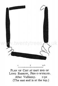
"The cist contained the osseous remains of several human individuals and of various domesticated animals, all in a very fragmentary condition ; the only complete human bones being those of hands and feet. Professor Keith (I believe) has identified the human remains as those of men, women and children, of short stature and flat-footed, with the usual characteristics of the neolithic type." [In Arch. Camb. it is said that at least a dozen individuals were represented] . "In sifting the débris I collected no fewer than 72 teeth, of which the greater number are human ; many shards of coarse, reddish pottery ; and three discarded flakes of flint - ^two with a milky white patination. The Rev. W. E. T. Morgan found two fragments of dark, lustrous flint. Charcoal has been found scattered throughout the cairn, but some of this appears to be recent.
"The most peculiar and baffling find, however, has been made by Mr. A. F. Gwynne of Glasbury. He discovered, at the spot marked with a cross, some dozens of small blue beads, of a glass-like substance, and tubes of vitreous paste, divided externally into rounded segments - precisely similar to those found in British barrows of the Early Bronze Age. Comment must be withheld until further light is thrown on this mysterious discovery.
"The most peculiar and baffling find, however, has been made by Mr. A. F. Gwynne of Glasbury. He discovered, at the spot marked with a cross, some dozens of small blue beads, of a glass-like substance, and tubes of vitreous paste, divided externally into rounded segments - precisely similar to those found in British barrows of the Early Bronze Age. Comment must be withheld until further light is thrown on this mysterious discovery.
The following account of the beads is given in Arch. Camh. p. 299:- They were "submitted to Mr. Horace C. Beck, who in conjunction with Mr. Reginald Smith, of the British Museum, were (sic) of the opinion that they might be attributed to an Anglo-Saxon burial of the sixth century A.D., and anyway not earlier than the second century, A.D."
Western Mail, Sept. 5th, 1921. (C. E. Vulliamy).
Man, Jan., 1922. Article No. 6. (C. E. Vulliamy) Plan.
Arch. Camb. Lxxvi. (7 S. i.), 1921, 296-7. (The Rev. W. E. T. Morgan and George Marshall).
7a Pipton Long Barrow![]()
Brecknockshire, 23 N.W. Parish of Pipton. 7a*.
Latitude 52° 01' 38". Longitude 3° 13' 26". Height above O.D., about 500 feet.
"About half-a-mile S.W. of Pipton Farm, on the hill which stands between the valleys of the Llynffi and the Wye. On the 6 inch map its outline is roughly indicated, but it is not described. A clump of trees conceals it ; the trees are growing out of the mound, which is of the usual type found in this district - oval, about loo feet long, orientated N.N.E.-S.S.W., with two upright slabs at the east end, placed across the axis, much weathered. The greater portion of the barrow is completely ruined. With the exception of the slabs mentioned (one of which is presumably the eastern terminal) there are no traces of the chamber." Extract from a letter from Mr. C. E. Vulliamy (age 38) (the discoverer of this barrow) dated Glasbury House, July 7, 1922.
8 Mynydd Troed Barrow![]()
Brecknockshire, 29 S.W. Parish of Talgarth. 8*.
Latitude 51° 56' 51". Longitude 3° 13' 13". Height above O.D., about 1250 feet.
This Long Barrow is not marked on the map and has not been noticed before. It was found quite accidentally during a walk. It is only 60 feet long, and is about 30 feet wide at the north-east end (highest and broadest). Here are the remains of two uprights visible ; the chamber has apparently been dug into a long time ago. Other large stones are visible above the surface of the mound further to the south-west. The two uprights are set at right angles to each other, the eastern-most being at right angles to the long axis of the mound. The other upright is to the north-west of it. Close by on the north-west is a very small mound which has been dug into. The mounds lie on a spur above the pass leading from Cwm Sorgwm to Llangorse and the north-west, where is a col between Mynydd Troed on the N.E. and Mynydd Llangorse on the S.W.
Visited August 7th, 1921.
9 Ty Illtyd![]()
Brecknockshire, 34 N.E. Parish of Llanhamlach. 9 *.
Latitude 51° 55' 51'. Longitude3° 18' 41''. Height above O.D., a little more than 700 feet.
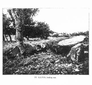
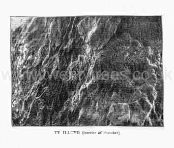
This is a most interesting Long Barrow, and in compiling the following account I have availed myself of notes made on the spot by Mr. Evan Morgan of Brecon, in addition to my own made on August 6th, 1921. Mr. Morgan also drew the plan reproduced here. One chamber of the barrow is intact and covered by a capstone. It has been rifled at some very distant date, and on three of the uprights are carved a number of symbols. They appear, however, to be of much later date than the chamber itself, and the inscription on the stone north of and outside the chamber is in lettering of apparently mediseval character. Mr. Morgan says, "Incidentally they suggest that they were made after the chamber was constructed, as they are more numerous on the western stone than on the eastern, and in my opinion better cut. I take this to mean that they were made by a person lying on his left side and using his right hand to cut. . There is on the south end-stone a crude design of what I think is a harp." (About 1½ by 2 inches). The chamber, as will be seen from the plan, is 5 feet 9 inches long by 3 feet 4 inches wide, measured inside. The capstone is 7 feet long by 6 feet wide. It more than covers the chamber.
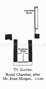
The designs on the inner side of the uprights are about four in all, and are constantly repeated. The commonest is a plain cross with small hollows or cups delicately chiselled at the end of each of the four arms. The diameter of the whole design is not more than an inch or two at the most. There are no incisions on the capstone. These designs were noticed and reported on the occasion of the Brecon meeting of the Cambrian Archaeological Association in 1853, when the probably correct opinion was expressed that they were of the Christian era. The name of the monument - which means "Illtyd's House" - vindicates Christian associations.
The five uprights in front and to the north of the chamber probably formed part either of an entrance passage or of another and now disrupted chamber. The original length of the mound was probably about too feet. It may have extended as much as 25 feet north of the chamber. At present it can only be seen clearly to the south of the chamber where it is between 4 feet and 5 feet. The width at the south end of the chamber is 56 feet. The height decreases southwards, and the highest part was originally no doubt that which covered the chanaber. A large yew tree grows on the western edge of the mound, and an elder opposite the entrance and close to the inscribed stone. Both mound and chamber are open and unprotected, the latter being used as a shelter by sheep, who have not improved the incised designs by rubbing against them. Protective measures seem very desirable.
In Gough's Camden is an engraving of nine of the incised markings, but the reproduction is not an accurate one. Gough states that the monument is mentioned by Lloyd, but gives no reference.
Gough's Camden, Vol. in, 103. (Plate iv, fig. 8, opp, p. 100).
10 Ty Isaf![]()
Brecknockshire, 29 S.W. Parish of Talgarth. 10 *.
Latitude 51° 57' 13". Longitude 3° 11' 26". Height above O.D., 874 feet.
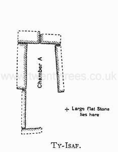
This Long Barrow is not marked on any map and was discovered by me quite accidentally on August 7th, 1921. It is about 95 feet long and lies in a small grass field immediately above and about 100 yards N.W. of Ty-isaf Farm. Two chambers are visible and there are indications of more.
Mr. Evan Morgan, of Brecon, contributes the following account:- "The width of the barrow at chamber A is 48 feet and its height about 3 or 4 feet at the place of measured width. North of A the barrow appears to be in its original state, but south of it considerable disturbance has taken place.
"Chamber A has been uncovered and its capstone is missing. Its length is about 10 feet and its width 4 feet. It is thus considerably larger than Ty Illtyd which is about 6 feet long by 3 feet 4 inches wide. [It is perhaps possible that Ty Illtyd had a double length, as is suggested by a slab-stone on the N.E. boundary of the existing chamber there.] The side stones or uprights at the S.W. corner are missing, but probably one of them is that now lying on the ground close to the chamber (See plan). The heights of the E. and W. end-stones above the present surface are about 3 feet and i foot 6 inches respectively. The floor of the chamber consists of a number of small stones.
"Chamber B has its capstone in position. It rests at the east end on an upright block about 18 inches above the present surface, and is embedded in the mound at its W. end. Its greatest exposed length is about 6 feet and its greatest width 5 feet 6 inches. The chamber is exposed to view from its east end, but it is not possible to take any measurements on the inside. The side-stones appear to have been removed ; at any rate they are not now visible.
"The supposed Chamber is suggested by an upright stone in the barrow, the top of which just rises above the surface. The mound here does not appear to have been disturbed, and the chamber, if such it is, is intact.
"The upright stone at D may be a relic of a i;ioo chamber which once existed at the southern end of the barrow. It is about 1 foot 6 inches long, 1 foot high, and between 3 and 4 inches thick. It lies in a rough undergrowth of thorns about 6 to 8 feet from the south end of the mound."
