Monmouthshire
Monmouthshire is in Section 2 Long Barrows.
62 Cleppa Park![]()
Monmouthshire, 33 N.E. Parish of Duffryn. 62*.
Latitude 51° 33' 33". Longitude 3° 02' 38". Height above O.D. about 140 feet.
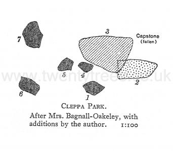
This is clearly the remains of a burial-chamber, but traces of the original covering mound are faint. It was probably oriented due E. and W., and as usual, the remains of the mound are most clear round the chamber at the east end where the mound is almost 50 feet across. To the west, traces of the mound are visible and may be inferred from hummocky brown patches of turf ; if the inference from these patches is correct the original length of the mound would have been about 135 feet. The chamber consists at present of seven stones - a capstone, three standing uprights, one fallen, and two small, half-buried stones. The monument is not marked on the 6 in. map (edition of 1902) ; it is situated on the brow of the hill 500 feet S.E. of the farm called Cleppa Park, after which (for lack of any distinctive local name) it is here named. It lies almost midway between an old quarry and a spinney by the side of a field wall.
The following description is taken from Mrs. Bagnall-Oakeley's monograph:- "About a mile from Tredegar Park is a farm, Gwern-y-cleppa [Gwern-y-clepai on the old MS. 2 in. O.S. map of 1812] the residence of Ivor Hael, and upon a sloping bank to the south-west [an error for south-east] in part of the ancient park are the ruins of what was originally a large cromlech. Facing the Bristol Channel, with a glorious expanse of hill and vale stretching out for many miles beyond it, the situation of this burial place is grand in the extreme, and when covered with its superincumbent mound of earth must have been visible at a very long distance. The supporting stones have been mutilated and the coverer [capstone] broken, but enough remains to show that the whole structure was of considerable size ; three of the uprights remain in situ, the largest being 3 feet 7 inches broad by 2 feet 9 inches thick, and measures 3 feet 6 inches high, but appears to have been broken off at this height ; another stone which evidently formed one of the supports, now lies partly under the coverer [capstone], and this measures 2 feet 6 inches square and is 4 feet 6 inches long, which was probably the original height of the cist [chamber] ; these stones are of conglomerate or millstone grit. The covering stone [capstone] has been split in two and only one part remains, which measures 7 feet 8 inches by 5 feet 6 inches, but as this is partly covered with soil at its edge it may be a little wider ; it is of siliceous grey sandstone. The cist [chamber] lay S.E. and N.W. [?] and the mound which covered it was about 50 feet in diameter, of which traces remain."

A visit of inspection on August 19th, 1921, confirmed the above description in every particular, except that it was not possible from the data available to discover any orientation for the burial-chamber. The remains are to-day in the same condition as they were in 1889 ; the field is under grass, and except for the fact that sheep are hollowing out the earth at the base of the stones for shelter and are rubbing against the stones themselves for other purposes, the monument appears in no immediate danger of destruction.
An account of some of the Rude Stone Monuments and Ancient Burial Mounds in Monmouthshire, by M. E. Bagnall-Oakeley, assisted by the Rev. W. Bagnall-Oakeley, 1889. Printed for the Monmouthshire and Caerleon Antiquarian Association by Mullock & Sons, Newport. 22 pp., 9 pl. (Plate II, opposite p. 12, is a view of the burial-chamber looking N.W.; the lower plan on Plate 11, opposite p. 10, is a plan of the burial chamber).
Arch. Camb. 1909, p. 271.
63 Heston Brake![]()
Monmouthshire, 30 S.E. Parish of Portskewett. 63 *.
Latitude 51° 35' 38". Longitude z° 42' 50". Height above O.D. 100 feet.
This chambered Long Barrow occupies the summit of a remarkable natural knoll, two thirds of a mile N.W. of Blackrock, the nearest point of the Severn estuary. The site is a striking one and commands a fine view over the shores on both sides. The visible remains consist of a double row or gallery of upright stones ; but they are so thickly overgrown with brambles that only those at the two ends of the gallery can be seen. There are faint but distinct traces of a mound or cairn, which was cer- tainly 70 feet in length and probably longer. The mound has suffered considerably from ploughing which has encroached upon it up the hill and thereby caused it to waste away on ail sides. On the north side of the knoll this ploughing has so steepened the slope that a small stony declivity has formed, now overgrown with thorns and briars. At the west end of the knoll (probably beyond the limits of the original barrow) are piles of stones, the remains possibly of the cairn, scattered and then re-collected and thrown here when the field was under cultivation. It is these stones which are marked on the map under the (wrong) impression that they are structurally connected with the "tumulus," which in their present position can hardly be correct.
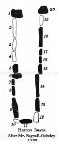
The gallery is 26 feet 3 inches long and contracts slightly towards the western end ; the width at the east end being 5 feet 6 inches and at the west end 3 feet 10 inches. The western end is closed by a single stone ; the eastern is open. The two stones at the eastern end of each row are the largest. The following notes were made on the spot, measure- ments being taken from Mrs. Bagnall-Oakeley's plan and account ; the stones are numbered in accordance with the plan.
1. A peaked upright of conglomerate sandstone with many white quartz pebbles in bands ; this is the highest stone in the monument and is almost 5 feet high (not now 6 feet as stated by Mrs. Bagnall-Oakeley).
2, 3, 4, were gone when the plan was made ; it is therefore presumed that their insertion on the plan was purely conjectural.
5, 6, 7. It was impossible even to see these on account of the brambles.
8. Is present.
9. Said by Mrs. Bagnall-Oakeley to be pierced with a diagonal hole about 1 foot in diameter, presumably artificially ; length 5 feet.
10. Was gone when the plan was made.
11. Seems to consist really of two in close contact ; it closes the west end and is 3 feet 10 inches long.
12. Was gone when the plan was made.
13. Is present ; length 3 feet.
14. Cannot now be seen; it is pierced like 9 according to Mrs. Bagnall-Oakeley's account. Length, 5 feet 2 inches.
15-17. One of these is visible only, but all may be present.
18. Is about 3 feet long (4 feet 9 inches according to plan), the stump only being now visible.
19. Is not now visible, and is either buried or destroyed.
20. Is a sandstone block (without pebbles) 2 feet 9 inches wide (north-south) and about 3 feet high.
From the above it appears probable that the monument is in much the same state of preservation as it was when described by Mrs. Bagnall- Oakeley in 1889 ; the subsequent growth of brambles, while obscuring the stones, has perhaps contributed towards their safety ; but the actual remains are so inconspicuous that they would hardly be noticed except by an expert, and a further measure of protection is therefore desirable.
The chamber was exposed on August 22nd, 1888 by the "members of the Monmouthshire and Caerleon Antiquarian Association and a few friends of the Clifton Antiquarian Club, and it was found to consist of two chambers connected internally." According to the plan the dividing line between these two cham- bers would appear to have been a little to the west of the middle of the gallery. "At the south corner of the west chamber were found part of a human skull and other bones much broken ; and in the east corner a few more fragments of human bones. In the lower chamber in the west corner some human teeth and finger bones, some bones of an ox and two smooth, round stones were discovered. . on the north side of the mound, the workmen came upon three pieces of broken pottery ; one of these was black and soft burnt, easily cut with a knife; another was grey, hard burnt, with lines upon it. . and near them lay a small piece of burnt bone. A third piece of pottery was very hard red ware, somewhat like Roman Samian ware."

These remains are now (August, 1921) in the Caerleon Museum, where they are exhibited with the original plan of the chamber made by Mr. Bagnall-Oakeley. Amongst the bones can be seen the head and part of the shaft of a human femur in a good state of preservation and part of the jaw of some animal. The plan conceals most of the objects "ex- hibited " but one piece of pottery is visible - ^the base of a small pot about 2 inches in diameter, slightly concave and covered outside with a greenish glaze. It is of mediaeval or later date. The label says: "The tumulus had evidently been opened at some time and all the bones violently broken." But whether this was so or not, the breaking was almost certainly original and caused, not by secondary disturbance, but by secondary burial.
Mr. J. G. Wood, M.A., F.S.A., contributes the following note:- "The names Heston Brake and Harpson Barn which occur on the map are in my opinion corruptions of Herberdeston, a 'Welsh Knight's fee' held of the lordship of Striguil in the 13th century by Matthew Deneband of ' Portskewet and Herberdeston see Inq. P.M. of Roger, Earl of Norfolk, March, 1306-7. Portskewet was then the name of St. Pierre ; and there is no other place than this hill to identify with Herberdeston."
Visited August 25th, 1921.
Rude Stone Monuments in Monmouthshire, by M. E. Bagnall-Oakeley, 1889, pp. 18-20, Plate VIII (sketch) and Plate IX (plan).
Proceedings of the Clifton Antiquarian Club, Vol. II. Part I (1888-9), pp. 64-66. The Chambered Tumulus at Heston Brake, Monmouthshire, by the Rev. William Bagnall-Oakeley.
Arch. Camb. 1909, p. 272.
64 Y Garm Llywd![]()
Monmouthshire, 25 S.W. Parish of Newchurch West. 64*.
Latitude 51° 39' 58". Longitude 2° 47' 56". Height above O.D. 700 feet.
This monument stands on a narrow neck of land forming the watershed between the Cas-Troggy Brook on the west flowing into the Severn at the Pill near Caldicot, and the Mounton Brook flowing into the Severn at Red Cliff. It lies immediately to the N.E. of the hedge on the N.E. side of the main road from Usk to Chepstow, in a green field, a little to the S.W. of some farm buildings. This main road was (according to Mr. J. G. Wood, M.A., F.S.A., from an unpublished paper by whom the following account is taken): "known as 'The New Usk Road' from Chepstow. That road cut in two the field in which the 'cromlech' stood, and which is itself bounded, on its eastern side, by the old trackway from Shirenewton over Earlswood Common, by Mynydd Bach to the great camp further to the north called Gaer-fawr. Until that new road was made, the 'cromlech' lay entirely secluded and out of the way of tourists, or indeed of any ordinary communication; and though the Gaer-fawr is described by early writers, the 'cromlech' appears to have been long unknown to, or unrecognised by, archaeologists.

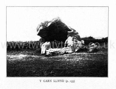
"The credit of its first mention belongs to the late Mr. Wakeman, according to a note in Arch. Camb. (1846, p. 277), where a woodcut of it is given. It is next mentioned in Cliffe's Book of South Wales (2nd ed. 1848) as follows:- 'Between four and five miles to the north of Caerwent [Map], on a hill forming part of a small farm called Gaer Llwyd, about a mile from Newchurch .... is the cromlech depicted in the accompanying sketch,' which is in fact a reproduction of the same woodcut. This sketch shows the covering-stone supported on the summits of three standing stones ; of which one carries the narrow (or north) end ; the other two support the shoulders of the broader end. The covering-stone is shown well clear of the ground, but it had a slope towards its narrow end, where the supporting stone leant inwards. At either end, but in positions where they could not have acted as supports, are shown two other standing stones. Around it were loose stones, apparently forming part of a circular enclosure.
"Cliffe proceeds: 'The upper stone is 12 feet long and about 3½ feet broad ; and the uprights vary from 4 to 5 feet. Vestiges of a trench and bank are discoverable round this cromlech, which is the only one in the county ....' [This last statement is not of course, true ; and I think the trench and bank, which can still he seen, are merely the remains of old field enclosures of comparatively recent date. - O.G.S.C.]
"In 1899 .... Mrs. Bagnall-Oakeley described the 'cromlech' .... and gave a drawing of the stone in its then condition. This shows that the leaning stone at the north end as drawn in 1846 had fallen, and the north end of the covering-stone was consequently down also. The detached stone at the north end is still standing [correct for August, 1931. - O.G.S.C.] ; but that at the south has either fallen or been much reduced. When I last saw the ' cromlech ' in 1915 the stones were still more displaced. Mrs. Bagnall-Oakeley writes: ' The base of the mound is visible on the north-west [an obvious error for north-east] but has been totally destroyed on the other side by the road to Usk. It is evident that the mound was removed long ago.' "
Mr. Wood criticises the name "Gaer Llwyd " applied to the monument, while "agreeing with her that the ' cromlech ' was most probably at first covered with a mound of earth ; and did not, as originally designed and completed, stand exposed." In support of this opinion, with which the writer is in full agreement, Mr. Wood quotes examples from Anglesey, Cornwall, Brittany and Ireland. The name Gaer-Llwyd occurs on the old MS. 3-in. O.S. Map of 1813.
The visible remains of the mound, or more probably, cairn, are slight, and consist of a pile of loose stones at the N.E. end. But the rest has doubtless been completely destroyed by the making of the new road. Originally the mound or cairn must have had a N.E.-S.W. orientation, the chamber being at the north-east end. A visit of inspection on August 36th, 1931, did not reveal any new features. The drawing given on Plate I. of Mrs. Bagnall-Oakeley's paper is not at all accurate, especially as regards the left-hand portion ; nor do the cliffs in the background exist.
In the paper quoted above Mr. Wood gives good reason for believing that the original name was Y Garn Llwyd, "the grey cairn and it is in fact described as a "Game Lloyde " in a survey of "Sherenewton," made in A.D. 1613 [P.R.O. Duchy of Lancaster, Div. 18, No. 10]. Mr. Wood quotes many examples in Wales and Ireland of the use of "grey" in the names of prehistoric monuments ; and agrees with Borlase (Dolmens of Ireland, p. 761) in suspecting that a "mythical meaning may underlie the simple adjective."
Although apparently in no immediate danger of destruction, the presence of a farm close by and of farm outbuildings within a few yards, makes its protection highly desirable ; especially in view of the probability that these are constructed in part of the loose stones of the cairn itself.
An earlier record than that of Mr. Wakeman is in existence, in the the form of a pencil drawing by Sarah Ormerod, dated August 9th, 1837. It is preserved in the Library of the Wiltshire Archasological Society at Devizes, Book N, folios 73 and 74.
Rude Stone Monuments in Monmouthshire, by M. E. Bagnall-Oakeley, 1889, p. 10, Plates I (sketch) and II (plan). [The latter is not now correct and appears never to have been very accurate].
Arch. Camb. 1846, p. 277; 1909, pp. 266, 271 (photo, on p. 267).