Europe, British Isles, South-West England, Wiltshire, Stonehenge Landscape, Stonehenge Monuments and Burials, Stonehenge Cursuses
Stonehenge Cursuses is in Stonehenge Monuments and Burials, Stonehenge Neolithic.
Europe, British Isles, South-West England, Wiltshire, Stonehenge Landscape, Stonehenge Monuments and Burials, Stonehenge Cursuses, Stonehenge Greater Cursus ![]()
Stonehenge Greater Cursus is also in South England Neolithic Cursus.
3650BC. Stonehenge Greater Cursus is a Cursus around 3km long, 100-150m wide oriented east-west near to Stonehenge. It was constructed between 3630BC and 3375BC. Its ditches are not uniform. The eastern ditch is fairly shallow, as is the southern ditch - being only 0.75m deep and 1.8m wide at the top. At the western terminal, the ditch is 2m deep and 2.75m wide.
Two artificial pits have been found near the east and west ends of the cursuses that align at sunrise and sunset at midsummer with Stonehenge.
Carbon Date. 2100BC. Early Bronze Age Carbon Dates
Report: antler:red deer
ID: 4998, C14 ID: OxA-1403 Date BP: 4100 +/- 90, Start Date BP: 4010, End BP: 4190
Abstract: Stonehenge Cursus, England
Archaeologist Name: Richards
Reference Name: Archaeometry 31(2), 1989, 207-234
Council for British Archaeology (2012) Archaeological Site Index to Radiocarbon Dates from Great Britain and Ireland [data-set]. York: Archaeology Data Service [distributor] https://doi.org/10.5284/1017767
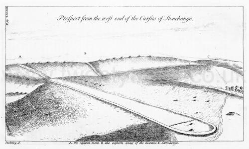
Stonehenge by William Stukeley. Table XXX. Prospect of the west end of the Cursus of Stonehenge. A. The eastern meta [Map]. B. the eastern wing of the avenue [Map]. C. Stonehenge.

Europe, British Isles, South-West England, Wiltshire, Stonehenge Landscape, Stonehenge Monuments and Burials, Stonehenge Cursuses, Stonehenge Lesser Cursus ![]()
Stonehenge Lesser Cursus is also in Stonehenge Neolithic.
3000BC. Stonehenge Lesser Cursus is a Cursus around 400m long an 60m wide around 750 north-west of the Stonehenge Greater Cursus oriented west-southwest and east-northeast. It is now only visible as a cropmark. The Stonehenge Environs Project discovered Red Deer Antlers picks that dated the monument to 3000BC.
Wiltshire Archaeological Magazine 1868 V11 Pages 40-49. The importance of discoveries, even apparently trivial, which throw light on the relative age of our more primeval antiquities, or which serve to connect one with another objects of this description, will at once be admitted.
The barrow [Cursus Barrow 49 G35a-c [Map]] in which the flint objects now exhibited were discovered is situated on Winterbourne Stoke Down, about 1½ mile north-west of Stonehenge. It is within a few yards of the western end of the low earthwork known as the "smaller cursus," and is numbered 49 on the "Map of Stonehenge, and its Environs," in Sir Richard Hoare's Ancient Wilts (vol. i. p. 170). It was passed over, when the barrows around it were generally excavated, in or about the year 1808; and all that Sir Richard says of it is, "No. 49 is a long barrow" (p. 165); a designation, however, which we shall find is not strictly appropriate, and is very liable to misconception. The form of the barrow is oval, it being about 140 feet in length by 70 in breadth, and in height less than 2 feet above the level of the down. Its long axis lies east and west, and it is surrounded by a slight ditch continued round both ends of the barrow. It is thus seen to differ in several particulars from the Long Barrow properly so-called; in which the interments, belonging apparently to the stone-age, and by simple inhumation, are confined to the broad east end of the barrow. The true long barrow is usually of much greater size, often reaching 250 or 300 feet and upwards in length, and having an elevation of from 5 to 10 feet, or even more. One end, usually that directed to the east, is almost always broader and higher than the other; but the most remarkable distinction is in the trench, which is carried the whole length of the barrow on each side, without being continued around the ends. These peculiarities of the long barrow are well shown in the engraving in "Ancient Wilts," (vol. i. p. 21. "I. Long Barrow") The Oval Barrow No. 49, like others of a similar form and description, belongs no doubt to a different and more recent period than the true long barrows, and to the same age as the circular barrows of the ordinary bowl and bell shapes. Its oval form appears to depend upon its having been designed for two or three distinct interments, placed at tolerably regular intervals.1 This variety of tumulus was not altogether overlooked by Sir Richard Hoare, by whom two or three such were excavated. Of one he gives a representation, as the specimen of his twelfth form of barrow, which he terms "Long barrow No. 2." His words are as follows: — "XII. Long Barrow No. 2. This tumulus in shape resembles a small long barrow, but diflfers from the larger kind, by having a ditch all around it." (p. 22.)
Note 1. For all purposes of argument, oval barrows (as distinguished from long barrows) and round barrows may be regarded as identical. The two are clearly coeval, and the work of the same people. An oval barrow, in my view, is a congeries of two or more round barrows.