Arrowheads
Arrowheads is in Weapons.
Windmill Hill Causewayed Enclosure [Map]. Historic England 1008446.
The monument includes a Causewayed Enclosure, a small mortuary enclosure, part of an early prehistoric field system and a group of eight Bronze Age round barrows forming the core of a wider round barrow cemetery, all situated on Windmill Hill, a prominent but low hill north-west of Avebury. Until recently, the Causewayed Enclosure and broadly contemporary mortuary enclosure were thought to be the earliest evidence for human occupation of the hilltop. Prior to this date, however, it would appear that the hill was under cultivation. On the eastern side of Windmill Hill are a series of slight earthworks which form the outlines of field boundaries and enclosures. Recent survey work has suggested that this field system runs beneath the enclosure and is therefore of earlier date. The causewayed enclosure has a small circular area surrounded by three roughly concentric rings comprising banks and ditches, centred just north and downslope of the summit of Windmill Hill. The ditches are interrupted at regular intervals by causeways, created as a result of the gang construction method used to form the ditches and banks. The outer limits of the enclosure form an oval ring aligned roughly south-west to north-east. The overall dimensions of the enclosure are 400m by 300m at the widest points. Numerous excavations of the causewayed enclosure, originally by Keiller, then by Smith in the 1960s, and more recently by Whittle, have contributed much to our understanding of the site. Finds have included Neolithic flint artefacts such as arrowheads, axe-heads, a sickle blade and scrapers. Ceremonial chalk cups, animal bones and skulls have also been found.
A type of Neolithic pottery found on sites across Wessex was first identified here and has taken the name of the site. The enclosure was in use from about 3000BC to around 2500BC. Broadly contemporary with the causewayed enclosure, and situated to the east and located immediately outside a causeway leading into the outer ring of earthworks, is a mortuary enclosure. This was used for the exposure of human corpses prior to their formal burial in mounds or chambered tombs such as nearby West Kennet [Map]. Although not visible at ground level, it survives as a rectangular enclosure 33.5m long by 22m wide defined by a buried ditch 0.3m wide.
South Street Long Barrow [Map]. Historic England 1008103.
The monument includes a Neolithic Long Barrow 70m south east of the Long Stones Cove aka Devil's Quoits [Map] standing stones and c.300m north east of the Long Stones long barrow, a contemporary funerary monument. The South Street long barrow, despite having been reduced by cultivation and partly excavated, survives as a slight earthwork visible at ground level. The barrow mound is aligned ESE-WNW and is known from excavation to measure 43m in length and 17m across. However, the mound has been spread by cultivation and now measures 64m in length and 43m across. Partial excavation has shown that the mound was constructed of chalk rubble tipped into a series of forty bays, created by the laying out of hurdle fences to mark out the site immediately prior to construction. This building method provided stability to the mound and guided the workforce in deciding where to dump the material quarried from two parallel flanking ditches. These ditches are located c.7m from the base of the mound on both sides and measure c.55m long and c.7m wide. The ditches have been gradually infilled by cultivation over the years but survive as buried features beneath the present ground surface. Radio-carbon dating of some of the finds from the later excavation date the construction of the mound to around 2750BC, making the monument over 4000 years old. Finds from the excavation included flint arrowheads, animal bones and fragments of pottery. Below the barrow mound evidence of early ploughing was discovered, taking the form of lines of cross-ploughing incised into the chalk.
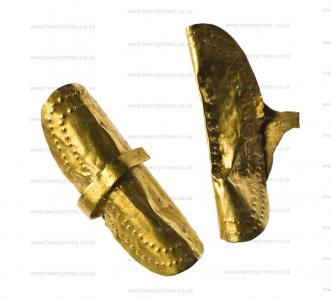
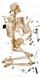
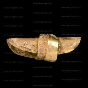
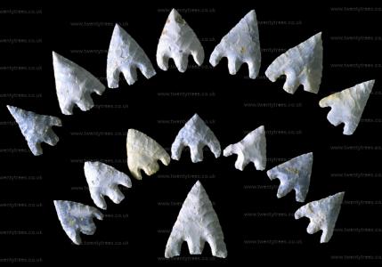
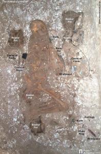
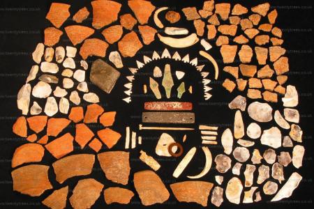
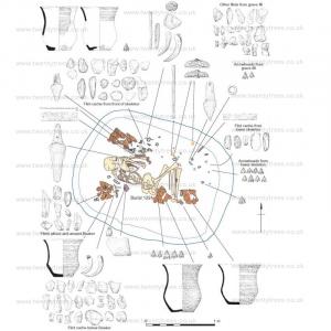
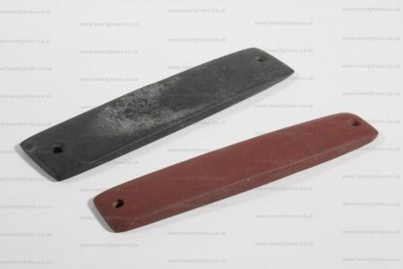
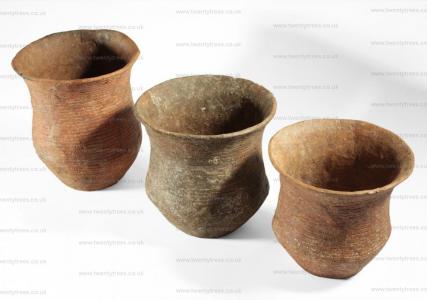
The Amesbury Archer [Map] is the remains of a man aged around forty at the time of his death from the Alps who was buried in Amesbury around 2300BC and discovered in May 2002 during the development of new housing. He is named 'The Archer' as a consequence of the large number of arrowheads found with him. His grave contained the largest number of artefacts of any grave of a similar period including the earliest known gold objects in England, five beaker funerary pots, three tiny copper knives, sixteen barbed flint arrowheads, a kit of flint-knapping, metalworking tools including cushion stones and some boar tusks. On his forearm was a black stone wrist guard. A similar red wrist guard was by his knees with a shale belt ring and a pair of earrings, the oldest gold objects found in England. An eroded hole in his jaw showed that he had suffered from an abscess, and his missing left kneecap suggests that he had an injury that left him with a painful lingering bone infection. His remains are on display in the Salisbury and South Wiltshire Museum [Map].
The Amesbury Archer's Companion is the remains of a man raised locally aged between twenty-five and thirty at the time of his death buried around 2300BC near to the Amesbury Archer. He appears to be related to the Amesbury Archer as they shared a rare hereditary anomaly, calcaneonavicular coalition, fusing of the calcaneus and of the navicular tarsal (foot bones). Inside his jaw were found a pair of gold earrings or hair ornaments in the same style as the Amesbury Archer's.
Photos sourced from Salisbury and South Wiltshire Museum [Map] and Wessex Archaeology.
Books, Prehistory, Prehistoric Artefacts, Weapons, Arrowheads, Leaf shaped Arrowhead
Adam's Grave [Map] is a Severn Cotswolds type chambered. The chamber was made of sarsen stones. It contained partial human skeletons. An leaf shaped arrowhead was also recovered. The tomb was 70m long, around 7m high with ditches on either side. It was partially excavated by John Thurnam in 1860.
Adam's Grave [Map] Historic England Entry:
The monument includes Adam's Grave, a long barrow set on a promontory above a steep south-facing escarpment. It survives as a substantial earthwork orientated NW-SE and is trapezoid in plan. The barrow mound is 70m long, c.7m high and survives to an average width of 20m. Flanking ditches, from which material used to construct the mound was quarried, run parallel to the north and south sides of the mound. These are 7m wide and up to 2m deep. The south-east end of the monument was partially excavated by Thurnham in 1860. Finds included part of a chamber formed from large sarsen stones, traces of human skeletons and a leaf shaped arrowhead. Numerous other long barrows are known in the area while a broadly contemporary enclosure at Knap Hill [Map] is situated on an neighbouring promontory.