Prehistoric Wales Neolithic Burials
Prehistoric Wales Neolithic Burials is in Prehistoric Wales, Neolithic Burials.
Europe, British Isles, South East Wales, Gower Peninsula Glamorganshire, Arthur's Stone Burial Chamber [Map]
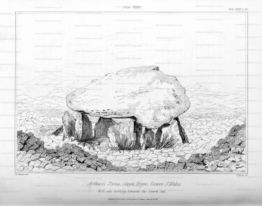
Arthur's Stone [Map] is a Neolithic Burial Chamber. Also known as Maen Ceti.
Wales Illustrated North Wales. Arthur's Stone Burial Chamber [Map].
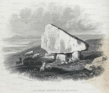
Archaeologia Volume 23 1831 Appendix. "Arthur's Stone [Map]," a Cromlech in the district of Gower. January 27, 1831. Extract of a Letter from Alfred John Kempe, Esq. F.S.A. to Henry Ellis, Esq. Secretary.
Europe, British Isles, Wales, Powys, Breconshire, Llangatock, Carn Goch Long Barrow [Map]
Long Barrows of the Cotswolds. Carn Goch Long Barrow [Map]
Europe, British Isles, Wales, Powys, Breconshire, Bronllys, Croesllechau Long Barrow [Map]
Long Barrows of the Cotswolds. Croesllechau [Map]
Europe, British Isles, Wales, Powys, Breconshire, Talgarth, Cwm Fforest Long Barrow [Map]
Long Barrows of the Cotswolds. Cwm Fforest [Map]
Europe, British Isles, Wales, Powys, Breconshire, Llanelieu, Ffostyll North Long Barrow [Map]
Archaeologia Cambrensis Volume LXXVI 1921 Miscellania. The Excavation Of A Megalithic Tomb [Map] In Breconshire by Colwyn Edward Vuilliamy (age 34).
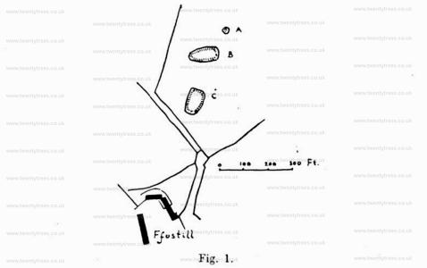
v8KvnzVNThe farmstead of Ffostill is slightly over one and a half miles from the Breconshire border-village of Talgarth, in a north-easterly direction, and about the same distance from the foot of the northern escarpment of the Black Mountains. It is situated at the head of a gully which runs down from the foothills below the Range, and is on relatively high ground—just under the 1,000 ft. contour-line of the Ordnance Survey. Close to the farm buildings there is a most remarkable, if not unique, group of three tumuli. Fig. 1 will explain the placing of the tumuli [Ffostyll North Long Barrow [Map] and Ffostyll South Long Barrow [Map]] far better than a written description, and shows their peculiar arrangement. The axes of the two lower ones point respectively 21 degrees and 67 degrees east of true north. The mound which is marked "A" is a barrow of irregular shape (32 ft. by 29 ft.); while "B" and "C" are magnificent examples of the late Neolithic long barrow, of impressive size and massive construction.
Before proceeding with an account of the excavation of the long barrow "C," which is the main object of this paper, it will not be out of place to give a few particulars regarding the group.
The barrow "A," which bears external resemblance to the burial mounds of the Bronze Age, proved, on a pit being sunk therein, to contain characteristic relics of that period—namely, deposits of thick, unctuous charcoal; very small fragments of calcined bone, reduced in some cases to a white powder; and a few pieces of tiint, one of which was a triangular retouched flake. It had not been disturbed prior to my investigation, but the pit, sunk exactly In its centre, did not reveal any traces either of pottery or of a kist. The blocks of sandstone, of which it is constructed, have been placed with some regard for architectural method.
Colwyn Edward Vuilliamy: On 20 Jun 1886 he was born to Edwyn Papendiek Vulliamy and Edith Jane Beaven. On 04 Sep 1971 he died.
Long Barrows of the Cotswolds. Ffostyll North Long Barrow [Map]
Europe, British Isles, Wales, Powys, Breconshire, Llanelieu, Ffostyll South Long Barrow [Map]
Long Barrows of the Cotswolds. Ffostyll South Long Barrow [Map]
Europe, British Isles, Monmouthshire South East Wales, Duffryn, Gwern-y-Cleppa Long Barrow [Map]
Long Barrows of the Cotswolds. Gwern-y-Cleppa Long Barrow [Map]
Europe, British Isles, Monmouthshire South East Wales, Crickhowell, Gwernvale Long Barrow [Map]
Long Barrows of the Cotswolds. Gwernvale Long Barrow [Map]
Europe, British Isles, Monmouthshire South East Wales, Portskewett, Heston Brake Long Barrow [Map]
Long Barrows of the Cotswolds. Heston Brake Long Barrow [Map]
Europe, British Isles, Wales, Powys, Breconshire, Talgarth, Mynydd Troed Long Barrow [Map]
Long Barrows of the Cotswolds. Mynydd Troed Long Barrow [Map]
Europe, British Isles, Wales, Powys, Breconshire, Llanigon, Pen-Y-Wyrlod Long Barrow [Map]
Archaeologia Cambrensis Volume LXXVI 1921 Miscellania. Excavation Of A Long Barrow At Llanigon, Co. Brecon.— This Long Barrow [Map] is situated in the parish of Llanigon, on a spur of the Black Mountains, at about the 800 ft. contour line, and close to a track-way which once led from the direction of Abergavenny, and over the mountain to a ford below Llowes, and so into Radnorshire. It is unrecorded except for a reference to it as a "Druidical Altar" in the Transactions of the Woolhope Club for 1898.
When the writers commenced excavations on it in September, 1920, four stones protruded some 6 to 12 in. through the surface, and evidently formed a small cist. The elevation of the mound is slight, about 4 to 5 ft., and the ovoid-shaped outline measures roughly, 50 ft. long by 30 ft. wide. The barrow is aligned through its longest axis nearly due east and west, the narrow end pointing to the west.
Operations were commenced by carrying a trench from the west stone of the cist for about 14 ft. towards the apex. This disclosed nothing but a mass of shaley stones, many of considerable size, some being as much as 4 ft. in length, laid mostly horizontallv, and showed the barrow to be a true carnedd or cairn, was verified later by openings made in other parts of the mound.
The east and west stones of the cist had fallen over and were leaning in a westerly direction; the other two had gone over to the north. The interior of the cist was next cleared, and consisted of stones up to 2 ft. in length mixed with a certain amount of black earth, and intermingled throughout with bones in a fragmentary state. The west stone measured 5 ft. in height and ft. 6 in. in length, and overlapped the two adjoining stones, which measured about 5 ft. in height and G ft. in length. The east stone fitted inside the north and south stones, and was only 3 ft. in. in height and 2 ft. 6 in. in length. The internal measurement of the cist was 2 ft. 6 in. wide, 5 ft. 6 in. long, and 5 ft. high. All traces of the capstone had disappeared.
Long Barrows of the Cotswolds. Pen-Y-Wyrlod Long Barrow [Map]
Europe, British Isles, South West Wales, Pembrokeshire, Preseli Mountains, Pentre Ifan Burial Chamber [Map]
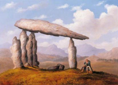 Before 1835. Richard Tongue (age 39). Pentre Ifan Burial Chamber [Map]. Donated by the artist to the Society of Antiquaries in 1835.
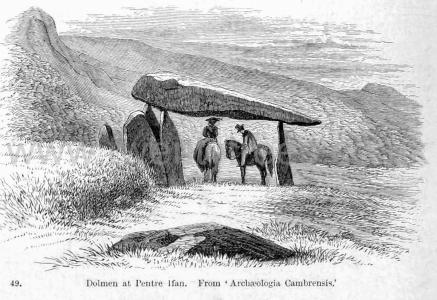
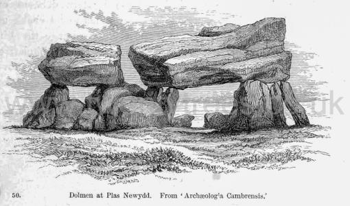
Rude Stone Monuments in all Countries Chapter IV. Almost all the so-called dolmens in the Channel Islands are of this class. One has already been given (woodcut No. 11), and it may safely be asserted that all chambers which were wainscoted with slabs, so as to form nearly perfect walls, and all that had complicated quasi-vaulted roofs were, or were intended to be, covered with mounds - more especially those that had covered pas- sages leading to them. There is, however, a very wide distinction between these sepulchral chambers and such a monument as this at Pentre Ifan [Map], in Pembrokeshire1. The top stone is so large that it is said five persons on horseback have found shelter under it from a shower of rain. Even allowing that the horses were only Welsh ponies, men do not raise such masses and poise them on their points for the sake of hiding them again. Besides that, the supports do not and could not form a chamber. The earth would have fallen in on all sides, and the connexion between the roof and the floor been cut off entirely, even before the whole was completed. Or, to take another example, that at Plas Newydd [Map], on the shore of the Menai Strait. Here the cap stone is an enormous block, squared by art, supported on four stone legs, but with no pretence of forming a chamber. If the cap stone were merely intended as a roofing stone, one a third or fourth of its weight would have been equally serviceable and equally effective in an architectural point of view, if buried. The mode of architectural expression which these Stone men best understood was the power of mass. At Stonehenge, at Avebury, and everywhere, as here, they sought to give dignity and expression by using the largest blocks they could transport or raise - and they were right; for, in spite of their rudeness, they impress us now; but had they buried them in mounds, they neither would have impressed us nor their contemporaries.
Note 1. 'Archæologia Cambrensis,' third series, xi. p. 284
Europe, British Isles, Wales, Powys, Breconshire, Pipton Long Barrow [Map]
Long Barrows of the Cotswolds. Pipton Long Barrow [Map]
Europe, British Isles, South East Wales, Glamorganshire, St Nicholas, Tinkinswood Burial Chamber [Map]
Archaeologia Cambrensis 1849 Page 327. Cromlech, St. Nicholas, Cardiff [Map].—Last February one of the Secretaries of the Cambrian Archaeological Association when examining the great cromlech [Tinkinswood Burial Chamber [Map]] in the wood near St. Nicholas (figured in Cliffe's excellent "Book of South Wales,") found under it three recesses branching off from the main chamber, one of which was still lined at the sides with slabs of stone. They had evidently been made to contain bodies, and the earth within them was of a dark colour, such as would be made by the decomposition of animal remains. In one to the north-east he found part of a human lower jaw, with one of the teeth in it in good preservation, and presented it the same day to Mr. Bruce Pryce, the owner of the monument. It is probably still in possession of that gentleman.
Archaeologia Cambrensis 1862 Page 92. Tinkins-Wood Farm cromlech [Map], though less perfect, is a much larger structure than the last. It stands just within a modern plantation, and near the junction of several hedges, which much obscure the adjacent ground. This cromlech is half buried, and is surrounded for some yards by a quantity of earth and masses of rock, evidently the remains of a large mound, and possibly of other cromlechs. The chamber is an irregular trapezoid. There have been at least seven uprights, of which four remain; those on the south, a long side, being absent. The figure was, no doubt, governed by the roof-stone, which, though now cracked and chipped, has been in one piece, measuring twenty-two feet by fifteen feet, and about two feet six inches thick. The chamber (the floor of which is below the surrounding surface) measures eighteen feet by fifteen feet, greatest dimensions; and is at present about five feet six inches high. A human skull is said to have been recently found by the Rev. H. L. Jones under this cromlech.
Archaeologia Cambrensis 1913 Page 100. Tinkinswood [Map].
Archaeologia Cambrensis 1875 Page 171. Not being satisfied with merely planning and sketching them, we were anxious to ascertain whether what had been thrown out from the interior resembled in any way the contents of similar localities examined elsewhere by myself and brothers; we therefore grubbed about amongst the debris of stones, etc., outside the St. Nicholas cromlech [Map], and soon discovered fragments of human teeth and unburnt bones, with portions of rude pottery, thus proving that its original use was the same everywhere, i. e., for the express purpose of burying the dead within, then covering them afterwards with a mound of earth or small stones, for the double purpose of concealing them, and marking the last resting place of departed chiefs or friends. There is no doubt whatever, that, whether we see cromlechs covered with a mound or denuded of their coverings, they were all sepulchral chambers and all originally covered by a mound or tumulus. Those we now find uncovered have been exposed to view by subsequent searchers after treasure, or the ground has in later times been removed for agricultural purposes.
Archaeologia Cambrensis Series 6 Volume 15 1905 St Nicholas Chambered Cairn. THE ST. NICHOLAS CHAMBERED TUMULUS, GLAMORGAN By JOHN WARD, F.S.A., Curator of the Cardiff Collections, National Museum of Wales
[The St. Nicholas Chambered Tumulus is now referred to as Tinkinswood Burial Chamber [Map]]
St. Nicholas is a small and ancient village, six miles west-south-west of Cardiff, on the highway from that city to Cowbridge, Neath and Carmarthen-a well-known road of Roman ancestry, and popularly known as the Via Julia. A mile-and-a-quarter to the south of the village is Dyffryn House1, the residence of Miss Cory and midway between the two, in a small plantation near Tinkinswood farmhouse, are the remains which are the subject of this paper. Plantation and farmhouse are on the apex of a wedge-shaped spur from the high ground at St. Nicholas. Along the south-west foot of this spur flows the Weycock, locally known as The Brook, a considerable stream which below Dyffryn House veers to the west and eventually flows into the estuary of the Dawe at Aberthaw while along the eastern foot is a small tributary which joins the parent stream a quarter-of-a-mile below the farmhouse. The summit of the apex is flat and about 280 ft. above the sea-level, with the plantation on its south-western brow and the farmhouse near its eastern. On its northern side, this small plateau is defined by a fall of several feet, beyond which the ground gradually ascends to 380 ft. at St. Nicholas. The surroundings are pleasantly diversified with hill and dale, woodland and pasture.
Note 1. Now usually spelled 'Duffryn.'
Europe, British Isles, Wales, Powys, Breconshire, Llanhamlach, Ty Illtyd Long Barrow [Map]
Long Barrows of the Cotswolds. Ty Illtyd Long Barrow [Map]
Europe, British Isles, Wales, Powys, Breconshire, Talgarth, Ty Isaf Long Barrow [Map]
Long Barrows of the Cotswolds. Ty Isaf Long Barrow [Map]
Europe, British Isles, North-West Wales aka Gwynedd, Carnarfonshire, Criccieth, Ystumcegid aka Coetan Arthur Burial Mound [Map]
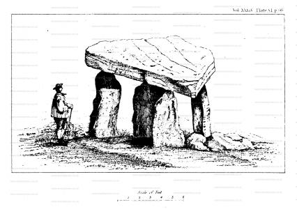
Archaeologia Volume 34 Section VIII. Account of Ystumcegid Cromlech [Map], in the parish of Llanfihangel - y - Pennant, county of Carnarvon. By NATHANIEL NEAL SOLLY, Esq. Communicated in a Letter to Captain W. H. Smyth, R.N., K.S.F., Director. Read December 5, 1850.
