Europe, British Isles, South-West England, Somerset, Stanton Drew
Stanton Drew is in Somerset.
Before 1420 Judge Richard Choke was born at Stanton Drew.
Europe, British Isles, South-West England, Somerset, Stanton Drew, Hautville's Quoit [Map]![]()
Hautville's Quoit is also in South England Neolithic Standing Stones.
Hautville's Quoit [Map] lies across the River Chew from the Stanton Drew Stone Circles. Historic England 1002475:
The monument includes a recumbent standing stone, situated on a low rise just above the floodplain, in the valley of and overlooking the River Chew. The recumbent standing stone survives as an earthfast monolith partially buried into a bank and measuring at least 1m square by 0.3m high. The standing stone was recorded by Stukeley writing in 1723 as being one of a pair of stones, and it is known to have been recumbent since the mid-17th century. It is believed to be an outlier to the complex stone circle of Stanton Drew which is the subject of a separate scheduling.
1664. Monumenta Britannica by John Aubrey ... The common people tell this incredible story, that Hakewell stood upon the top of Norton Hill, about half a mile off where the Coyte [Map] now lies, and coyted it down to this place; for which having the Manor of Norton given him, and thinking it too little, did give it the name of Norton Mal-reward which they pronounce small reward.
Around 1780. The History and Antiquities of the County of Somerset by Reverend John Collinson ...
In the road lies an immense stone called Hautville's Coit [Map] (a name that has sustained for many ages) and is by tradition reported to have been thrown hither by that gigantick champion Sir John Hautville, from Mays-Knolle-Hill upwards of a mile distant, the place of his abode. The tump on that hill is also affirmed to have been the cleanings of the same man's spade, and so confident are the common people of the reality of the manoevre, that a farmhouse erected of late years near the coit was distinguished by the title of Hautville's Coit Farm, which doubtless it will preserve until records are no more.
This stone was formerly of a vast magnitude, being computed to have weighed upwards of 30 tons; but the waggon loads of fragments that have been broken from it at different times, for the purpose of mending the roads, have diminished its consequence as to bulk and appearance, though not as to antiquity or the design of its erection, for it was part of a very remarkable monument of antiquity, which has distinguished the parish for many ages and has diverted the steps of many a traveller... [ie, the circles at Stanton Drew].
History of Somerset: Stanton Drew. The river Chew washes this parish, and runs under a stone bridge northward from the church in its way to Pensford. The road to that town from Chew passes to the north of this river, and in the road lies an immense stone called Hautville's-Coit [Map], (a name it has sustained for many ages) and is by tradition reported to have been thrown hither by that gigantick champion Sir John Hautville, from Mays-Knolle-Hill, upwards of a mile distant, the place of his abode. The tump on that hill is alfo affirmed to have been the cleanings of the same man's spade; and so confident are the common people of the reality of the manoeuvre, that a farm-house erected of late years near the coit, was distinguiftied by the title of Hautville's-Coit Farm, which doubtless it will preserve till records are no more. This stone was formerly of vast magnitude, being computed to have weighed upwards of thirty tons; but the waggon loads of fragments that have been broken from it at different times, for the purpose of mending the roads, have diminished its consequence as to bulk and appearance, though not as to antiquity or the design of its erection; for it was part of a very remarkable monument of antiquity, which has distinguished this parish for many ages, and has diverted the steps of many a traveller.
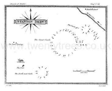
Memoirs Historical and Topographical of Bristol Volume 1 Chapter. 100. North or north-westward from this cove are two large stones lying flat in a field, called Lower Tyning: they are said by Wood to be 3250 feet (i.e. two-thirds of a mile) from the center of the great circle.—Lastly, north-east from the great circle beyond the brook by the side of the road, as you approach Stanton Drew from the east, is a very large stone, called Hackell's Quoit [Map]: others call it Hackham's, and Ackam's, and Hakim's Quoit; but I am informed that the first is the proper orthography, derived from Hawkwell, a former possessor of land on the spot; but Stukeley calls him "Hautvill, a famous champion, of whom Legends are printed under the name of Sir John Hawkwell, as vulgarly pronounced."—lf the preceding account be compared with that given by Stukeley, it will be found, that this interesting monument of our ancestors, has suffered no discernible damage, since the time when that learned Antiquary visited it about A'D' 1723. A reprint of his and Musgrave's Views would be essentially useful for a History of the Britons. Stukeley supposes the original number of stones to have been about 100, the hypothesis of concentric circles inducing him to set down the number beyond all bounds of probability. My conjecture would be, not more than 60. Beside which some others, as it is said by the neighbours, lie on the ground unnoticed in unfrequented parts of the parish.
Archaeological Journal Volume 15 Pages 199-215. Collinson was of opinion that there had been avenues to the great circle, and that the large stone north-east [Hautville's Quoit [Map]] from it on the other side of the river had served as part of a portal to one of them. Stukeley, however, did not believe that there had ever been any avenue to this work. Of the celebrated stone just mentioned, Aubrey gives the following account: "About a quarter of a mile from this monument of the Wedding is a stone called Hakewell's Coyte, which is a great roundish stone, of the shape of a coyte; length of it is 10 feet 16 (sic) inches, broad 6 feet 6 inches, thick 1 foot 10 inches, and lies flatt, and seems to have been left: it is of the same sort of stone with those at the Wedding. This is not erect as they of Stoneheng, &c. The common people tell this incredible story, that Hakewell stood upon the top of Norton Hill, about half a mile off where the coyte now lies, and coyted it down to this place; for which having the Manor of Norton given him, and thinking it too little, did give it the name of Norton-mal-reward, which they pronounce Small-reward. That in these parts anciently was one Hakewell, a person of great estate and strength of body, is manifest by the figure in his monument in Chew Church."
Europe, British Isles, South-West England, Somerset, Stanton Drew Cove [Map]![]()
Stanton Drew Cove is also in Avebury Type Cove.
Stanton Drew Cove [Map] is a Avebury Type Cove constructed around 3500BC ±500 years near to the Stanton Drew Stone Circles. It is now in the garden of a local pub. The stones are of a different rock to the stones that form the stone circles. The stones are believed to be the portal stones of a Chambered Tomb rather than an actual Cove; Coves appear to be a later form of monument.
Avebury by William Stukeley. The cove [Map], as most commonly, consists of three stones, set in a half-moon figure, or, to be more exact, upon the end of an ellipsis whose focus, I suppose, would be in a line upon the foremost edges of the two wings. This is situate in the south-west; part of the oval knoll of ground that contains the whole ; at present in an orchard south of the church, and west of the nunnery before mentioned. The wings are standing, but much diminished by age or violence ; some great pieces being broke off: the stone on the back is fallen down, being a larger one: it is 13 foot long, and 8 broad; therefore of the same dimensions with Hautvil's Coyt [Map], before spoken of. This cove opens to the south-east.
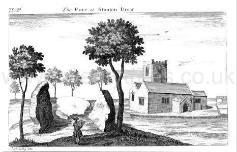
History of Somerset: Stanton Drew. This part, though in itself immense, and occupying a large extent of ground, appears to be only the centre of the stupendous building. Doubtless there were many avenues to it, and Hautville's-coit seems to have served as part of a portal to one of them. There were also other outworks, one of which [Stanton Drew Cove [Map]], consisting of three prodigious stones, placed in a triangular form, still remains on a small eminence, in an orchard belonging to Mr. Fowler, southwest from the church. Two of these ftones are standing; the largest measuring ten feet in height, and six feet and a half in width; the one that is fallen is fourteen feet long, and eight feet wide.1
Note 1. Notes taken April 9, 1789.
Memoirs Historical and Topographical of Bristol Volume 1 Chapter. 99. North-west from the last circle, little more than 100 yards distant, is a Core [Stanton Drew Cove [Map]], ten feet wide and about eight feet deep, formed of three large flat stones 18 inches thick: they are reckoned by Wood to be 992 feet from the centre of the great circle. The stone which formed the back is thrown down, and apparently two corners are broken out: it is 13 feet long, perhaps two feet of it were underground. The south-western stone is standing in it's place, eleven feet high. The north-eastern is standing, only five feet high; whether it was once higher, which is probable, cannot be ascertained. Such coves are supposed to have been erected for judicial purposes, where the Druids sat and administered justice to the neighbouring tribe. This cove [Map] is within a stone's throw from the Church of Stanton Drew.
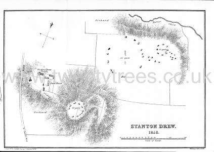
Proceedings of the Somerset Archaeological and Natural History Society Volume 14 Pages 161-172. The Cove [Map] is situated a little to the south-west of the parish church, and is formed by three stones standing in an orchard. The two side stones are still standing, but that which formed the back is fallen down. These three stones are 18 inches thick, and the respective lengths of from 10 to 14 feet. The cove [Map] is 10 feet wide and about 8 feet deep, and opens to the south-east.1 The first circle is distant 157 yards from this cove [Map] in an easterly direction the number of stones which originally composed the circle appears to have been twelve, and the diameter of the circle, according to Mr. Crocker, is 129 feet. There are now remaining in the orchard, in w'hich it is partly situated six stones, and three in the adjoining field, and one under the wall which separates the orchard from the field, making ten in all; but the circle when complete probably con sisted of twelve. 150 yards from this circle in a north east direction, is the Great Circle, the diameter of which, according to Mr. Crocker^s measurement, is from east to west 345 feet, and from north to south 378 feet. It is therefore, strictly speaking, an ellipse, with the longer axis from north to south. The number of stones remaining is fourteen, of which three only are standing, others are said to be beneath the surface. The tallest of the standing stones is 7J feet high, and about 6 feet thick. They are all of a very rude appearance. The original number was probably twenty-four. Seyer says twenty-seven.
Note 1. See Stukeley’s Itin. Curiosum.
Long Barrows of the Cotswolds. "Stukeley himself notices that 'the very same report remains at the Druid temple of Stanton Drew,' Somersetshire. 'This noble monument is vulgarly called the Weddings; and they say'tis a company at a nuptial solemnity thus petrify'd. In an orchard near the church is a cove [Map] consisting of three stones like that of the northern circle in Abury or that of Longstones; this they call the parson, the bride, and bridegroom. Other circles are said to be the company dancing; and a separate parcel of stones standing a little from the rest are call'd the fidlers, or the band of musick.'
Archaeological Journal Volume 15 Pages 199-215. We will first direct our attention to the three stones in the orchard on the higher ground to the south of the church, and which form what Stukeley called The Cove [Map]. The two side stones are standing, and that which formed the back is fallen down. These three stones are 18 inches thick; the prostrate one, of which, perhaps, 2 feet were under ground, is, according to Collinson, 14 feet long, and 8 feet wide; the taller of the two which are upright is 10 feet high and in width; the other is only 5 feet high. Stukeley makes the recumbent stone "13 foot long, and 8 broad." Seyer says it is 13 feet long, and that the south western of the standing stones is 11 feet high. " Whether it was once higher, which is probable, cannot be ascertained." The Cove [Map] is 10 feet wide, and about 8 deep, and opens to the south-east. The best print I have seen of it is that given by Stukeley in the Itinerarium Curiosum.
Europe, British Isles, South-West England, Somerset, Stanton Drew Stone Circles
Stanton Drew Stone Circles is also in South England Stone Circles.
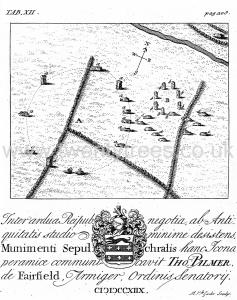
Belgium Britannicum Page 206. 1719While I was preparing this press, a noble Belgian, Mr. Nathan. Palmer, being the first to know the antiquities of the country, I received letters; in which he very humanely shared with me the most ancient monuments, and (it seems he used) Roman remains, drawn with his own hand. This monument [Stanton Drew Stone Circles], commonly called [The Wedding], is seven and eight miles westward of Acquis caldis, not far from the military road, which is described in our Map of Belgium. It is made of stone circles, different in number, unequal in diameter, more or less perfect; which are carved in honor Tab. XIV. you may see First, to show their state, as they are now; then I will try to explain the end to which they were constructed.
It is the center of a larger circle. Thirteen stones remain in the Periphery, and only three of them have been erected: but it is probable that the completed Circle, as it once was, had 32 Peripheral Stones, and that they had been separated from each other by 11 rods.
The center of another circle is B, from which to the periphery the radius is 16 rods. There are two interior circles, the innermost of which is completely intact, has cylindrical stones, and if you drop one, they are raised; they are nine feet high, with a circumference of twenty-two feet.
Still others are Stones, not dissimilar to those seen in the circles, but now distant from them; such as these formerly belonged to the circles, but I think that by some chance they were taken from the places of Semoveri, and others to the civil affairs, that is to say, buildings, roads fortifying, and the like.
Avebury by William Stukeley. There is an old proverb common in Somersetshire, "Stanton Drew, a mile from Pensford, another from Chue;" which should denote some peculiar regard and excellence in that town, and direction for the ready finding it: and in fact it highly deserves to be celebrated, upon account of that remarkable monument, vulgarly called the Weddings [Stanton Drew Stone Circles], whose name only is but just known to the curious and learned world. To redeem it from further obscurity, I took a journey thither from the Bath in July 1723, where calling on my friend Mr. Strachey, a worthy fellow of the Royal Society, and who has shewn his knowledge in his nice remarks upon the neighbouring coal-mines, we made mensurations of this notable work together. I find it is the most considerable remnant of the ancient Celts which I yet know, next to Stonehenge and Abury. Mr. Aubrey, that indefatigable searcher-out of antiquities, is the first that has observed it ; and I believe Mr. Strachey, living near the place, is the first that measuired it, since the original ground-line was stretched upon the spot. To open a more exact view of this noble antiquity, observe we that there is a little stream runs into the Avon between Bath and Bristol, called Chue, arising near here at a synonymous town, and first passes under a stone bridge at Stanton Drue, where making a pretty turn, as it were, half inclosing our monument, a little further it comes to Pensford ; which is an old British name, for it is written Pennis-ford, Pen ise signifying the head of the river. It was a common usage among all ancient nations, so with our ancestors, to pay a sacred reverence to the fountains of rivers, and frequently were they fought for upon religious occasions, judging a divinity must needs reside where so beneficial an element takes its rise. The road from Pensford to Chue goes along the north side of the river and there, half a mile above, and half a mile below the bridge, lie two great stones, called Hautvil's Coyts [Map], according to the apprehension of the common people, said to be pitched there by Sir John Hautvil, of these parts, a famous champion, of whom legends are printed under the name of Sir John Hawkwell, as vulgarly pronounced. These stones now lie flat upon the ground by the road side, but said to have been standing, and much larger than they are at present ; for some pieces have been knocked off. We measured that toward Pensford 13 foot long, 8 broad, and 4 thick, being a hard reddish stone. Stanton Drue church bears here south-west. What regard this has to the temple which it overlooks on the other side the river, and from higher ground, I cannot fay ; whether it is the remnant (together with the former) of some avenue, or whether it was carried thither, or laid for fome direction to those that lived on that side the river. Repassing the bridge, and entering the inclosures east of the church which belong to a farm there, we come to the Weddings. Here is an old manor-houfe adjacent, which has been a castle ; for the walls are crenated, and some half-moons built to it. The farm-house is an old stone building, said to have been a nunnery, probably founded by some pious lady of the manor. There is a great hall in it, open to the cieling, handsomely made of timber work, and two arched windows with mullions on each side and all the windows of the house are arched in the same manner: at the east end is a winding stone stair-case, and near it, in the yard, an elegant stone dove-cote, round, with six buttresses. This house, with the church and that part of the grounds which is the site of our monument, is a knoll of rising ground, of an oval form, stretched out with a whole broad side against the river, half embracing it with a circular sweep, and but little space between it and the river; and that side from the river has a delicate acclivity or valley winding round it, answerable to the river. The longer axis of this knoll is from north-east to south-west: the major part of it declines manifestly gently toward the river, or northward, and is finely guarded from the north winds by a ridge of hills adjacent ; upon the summit of which is an ancient fortification, called Miz knoll, in the road to Briftol: this is a pleasant place, full of hedges and trees growing very tall, especially elms. The country is stoney, covered over with a reasonable stratum of sandy ground, mixed with clay, which is rich enough. One would imagine this knoll was pitched upon by the founders for the sake of its figure, and because capable of giving a sufficient stability to their work: its declivity carries off the rain, always regarded in this manner of building; for that would loosen the foundations. Here is a fine large area between the temples, for the rites of sacrifice, &c.
History of Somerset: Stanton Drew. It [Stanton Drew Stone Circles] stands in an inclosure northeastward from the church, and consists of the remains of four assemblages of huge ponderous stones, forming two circles, an oblong, and an ellipsis. The first, or largest circle, part of which is crossed by an old hedge-row, is westward from the other parts, and is three hundred feet in diameter, composed of fourteen large stones, some of which are fallen and lie flat upon the ground; the second circle eastward is eighty-four feet in diameter, and consists of eight stones; the oblong, consisting of five stones, stands between the two circles, but rather inclining to the south; and at the southeast extremity of all is the ellipsis, which is forty feet in length, and has seven stones, one of them placed as it were centrically, and out of the line of arrangement. The stones which form the second or inner circle are the largest; one of those on the west side being nine feet high, and twenty-two feet in circumference, and would upon a calculation weigh upwards of fifteen tons. It seems to be a composition of pebbles, grit, and other concrete matter, and never to have been hewn from the rock.
Memoirs Historical and Topographical of Bristol Volume 1 Chapter. 95. Stanton Drew
95. Stanton Drew lies in Somersetshire, about seven miles from Bristol on the south, and on the further side of Dundry-hill. It's name sufficiently shews, that it was the Stone-town of the Druids. It contains three circles of stones, (beside some other stones contiguous to them), which are commonly called the Wedding, and a silly story is told, that the whole company were suddenly turned into stones: here stood the bride and bridegroom, here the fiddler, here a set of dancers The largest and the smallest circles are both situate in a field, called Stone-Close, adjoining to the dwelling house of Mr. Coates. The annexed plan represents the whole structure under the following rule: if the stone projects largely above the ground, it is represented by a black mark: if merely visible or tangible, by an outline: if quite under-ground, and only suspicious, by dots. The whole plan is made with great care, and is (as I believe) the first accurate one ever published. I have added two plates, giving a view of some of the most remarkable stones: the lithographic manner, in which they are represented, suits well with the rude appearance of the originals. The great circle according to my measurement is 342 feet diameter: Mr. Wood makes it 378, and Dr. Stukeley 300: the outward circle of stones at Stonehenge has only about 100 feet diameter, and that of Abury 1215 feet at the mean. The measurements in the Gent' Mag' are not worth attention. In the great circle at Stanton Drew only five stones are actually standing in their places; so that the first appearance is not particularly striking. How many there were originally it is impossible to ascertain, for the distances of those which remain are very irregular, and must have been so from the beginning, if the fallen stones still lie where they fell, which is probably the case. I have set down 27 in the plan, which (as I think) may be depended on; there were more without doubt: Dr. Musgrave, who wrote in 1718, supposes that there were once 32; probably there were many more. They were not perfect in his time: it is said in the village, that about 100 years ago, great depredations were made on them, and many were broken for the purpose of mending the road Dr. Stukeley says that about ten years before his time (he visited it in 1723) they suffered great dilapidation; until which time, he says, they were perfect. The greater part of them are magnesian limestone: but some are red sandstone, and some breccia.
Proceedings of the Somerset Archaeological and Natural History Society Volume 14 Pages 161-172. On the Megalithic Remains at Stanton Drew. By The Rev. H. M. Scarth (age 52), M.A., Prebendary of Wells.
Archaeological Journal Volume 15 Pages 199-215. The Druidical Temple at Stanton Drew, Commonly called The Weddings. By William Long.
William Long: Wiltshire Archaeological Magazine 1857 V4 Pages 307-363. Abury By William Long, Esq., M.A. Wiltshire Archaeological Magazine 1878 V17 Pages 327-335. Abury Notes. By William Long, Esq., M.A., F.S.A. Archaeologia Volume 84 1935 Section VI. Lukis and Smith also noted and planned several pits in which stones originally stood. Hoare noted eight of these depressions, but Smith and Lukis were able to add twenty-five others not previously recorded. This increased William Long’s table of stones in 1857 from twenty-nine to forty-seven. A number of these stones of Smith and Lukis were declared by Stukeley to have been demolished before he made his plan in 1724.
Munimenta Antiqua Volume 1. And the well known circles of stones, at Stanton Drew, in Somersetshire, seem to have been designed for astronomical observations, and for superstitious rites conjointly. The principal one there, forms, like that at Stone Henge, in reality a sort of ellipsis, of about 330 by 260 feet, and not a regular circle. And there are stones cautiously placed nearly on each side of the meridian; two at the one end, for a sort of observer's index, and two at the other, as if designed for leading sights to direct the eye to certain points in the heavens equally distant, a little to the east and west of the south: and so in like manner two to the east, and one on the west side for an index; as if to observe the rising of certain stars and planets. The rest of the stones of this circle are at most unequal distances;1 but yet apparently fixed in their situations with great circumspection. Within the circuit appears, lying on the ground, a great altar stone, as at Stone Henge, placed towards the east; and at some distance on the outside of the circle, in the same direction, is a great and high stone of memorial. All these circumstances should be borne in mind, to compare them with other remains of a similar kind.
The stones in general are in height, from 8 to 14 feet; which would lead the eye of an observer to a considerable height in any azimuth circle; and from 6 to 8 or 10 broad; and 3 or 4 feet thick.
Near adjoining to this great circle of stones, are two other smaller ones, which seem plainly to have been mere appendages to this.
And not far off, towards the north-east, on an high hill, is an antient fortress containing about thirty acres, called Stanton Bury; which appears to have been British; whilst at the same time a number of barrows, on the top of Mendip hill, point out the former residence of many Britons, and Druids, of high rank, in these parts; as well as near Stone Henge.
Note 1. Plans and Views of the whole may he seen in Gough's Camden, Vol. I. p. 81. Wood's Description of Bath, p. 1 4 7, 15 9. And somewhat more correctly in the Gentleman's Magazine for 1 7 8 5, p. 7 62.
Hautville's Quoit [Map] lies across the River Chew from the Stanton Drew Stone Circles. Historic England 1002475:
The monument includes a recumbent standing stone, situated on a low rise just above the floodplain, in the valley of and overlooking the River Chew. The recumbent standing stone survives as an earthfast monolith partially buried into a bank and measuring at least 1m square by 0.3m high. The standing stone was recorded by Stukeley writing in 1723 as being one of a pair of stones, and it is known to have been recumbent since the mid-17th century. It is believed to be an outlier to the complex stone circle of Stanton Drew which is the subject of a separate scheduling.
Europe, British Isles, South-West England, Somerset, Stanton Drew Stone Circles, Stanton Drew Avenues ![]()
Stanton Drew Avenues had two Avenues. One extending from the Stanton Drew Great Circle [Map] in a north-east direction towards the River Chew. The second between the Stanton Drew Great Circle [Map] and the Stanton Drew North East Circle.
Europe, British Isles, South-West England, Somerset, Stanton Drew Stone Circles, Stanton Drew Avenues, Stanton Drew Avenue 1
Stanton Drew Avenue 1 is also in South England Avenues.
Europe, British Isles, South-West England, Somerset, Stanton Drew Stone Circles, Stanton Drew Avenues, Stanton Drew Avenue 2
Stanton Drew Avenue 2 is also in South England Avenues.
Europe, British Isles, South-West England, Somerset, Stanton Drew Stone Circles, Stanton Drew Great Circle [Map]![]()
Stanton Drew Great Circle [Map] is a Stone Circles 113m in diameter constructed around 2400BC. It originally consisted of around thirty stones [Note. 30 used in many ancient calendar for days of the month.] of which twenty-seven survive today. It isn't clear whether the stones were surrounded by a ditch or a bank, or both.
In 1664 John Aubrey (age 37) visited Stanton Drew Great Circle [Map].
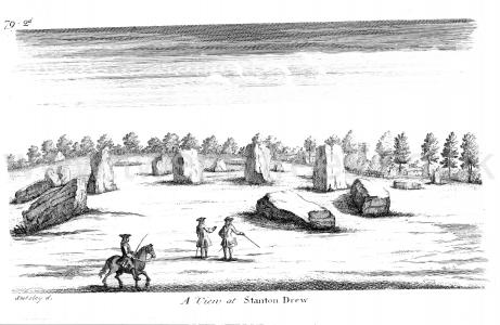
On 23 Jul 1723 William Stukeley (age 35) made sketches of Stanton Drew Great Circle [Map].
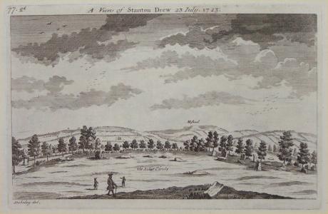
Avebury by William Stukeley. But 30 foot from this circle is the circumference of the outer circle of the quincuple one Stanton Drew Great Circle [Map], or five concentric circles, the centre whereof is in an angle of 20 degrees more southerly from the line that connects the centres of the two single circles; so that it bears a little northerly of the east from the solar circle. The manner of thus conjoining five circles in one is very extraordinary, and what I have no where else met withal ; and its primitive aspect must have had as remarkable an effect, by the crebity of the stones, as their intervals: and, upon moving towards them, or sideways, they must have created the same beautiful and surprising appearance to the eye, as the more learned architects have endeavoured by the multiplicity of columns in their portico's, forums, and the like, of which Vitruvius speaks: yet I think, in my judgement, this circular work must needs vastly have exceeded, in this particular, those most celebrated works of the Greeks and Romans ; because in a strait walk there is but always the same variety (if we may talk so) presented to the eye ; whereas in ours, the circles not being exactly at the same distance from one another as the stones are, and therefore not confining themselves to so strict a regularity, it must have heightened that agreeable diversification. It is very obvious, that the compilers used art and consideration in adjusting the diameters with the number of the stones, and that one circle should not be vastly disproportionate to another: thus the outermost circle is 310 foot in diameter; therefore it receives 32 stones at 30 foot interval: the next is 250 in diameter, with 28 stones: the next, 230; consequently requires 22 stones to complete it: the next is 150 foot in diameter, consisting of 16 stones ; the innermost is 90, therefore has 9 stones ; but then two of them are crowded together, and set at an angle a little obtuse, so that they form a fort of niche, or cove, of a different manner from any other. Several of these ftones are fallen, several stand ; which may be better understood by surveying the drawings, than by a tedious recapitulation: therefore I took different views of the work hereabouts, where it is most intire, that in after-times, by comparing the prints with the life, the difference may appear, if any shall be ; but I hope they ever will be useless to those that view the place itself, and that the owners of the estate will preserve the monument for the glory of their country.
Avebury by William Stukeley. Five hundred foot distant from this, going north-easterly, viz. with an angle of 20 degrees northerly from the east, and across the orchard, and a pasture, is the circumference of the greater single circle [Stanton Drew Great Circle [Map]]; the centre of it is in the next pasture to the north-east; it is 300 foot in diameter, and composed of 30 stones, set at the distance of 30 foot, as before: about 20 of the stones are remaining, but of that number only three standing. The whole circle is contained in three pastures ; the plain on which it stands descends gently toward the river, and keeps it constantly dry.
Avebury by William Stukeley. The idea upon which some of thefe stones are formed, is different from any I have observed elsewhere. Abury and Stonehenge, and all others yet come to my knowledge, are broad stones: these are square, or what we may call pilasters ; I mean those of the innermost circle [Stanton Drew Great Circle [Map]], or cell, of what I name the Planetary temple: the rest are all of equal dimensions, being six foot broad, nine high, and three thick ; so that their base is a double cube, their length a cube and a half, which shows sufficiently that the builders of this work, as in all others of the like, studied proportion, whence beauty flows. The stones of the outer circle at Stonehenge are of the same model as to the base, but higher upon the breadth, being likewise a double cube. I understand all the while in our monument, that these are Celtic feet, for such I found them, and by that scale is the construction of the whole: also what I speak of is their measure above ground; for I did not desire to indulge a dangerous curiosity in searching how deep they are set in the ground, which has been too fatal already in these antiquities.
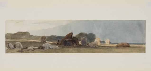 1832. William James Müller (age 19). Watercolor of Stanton Drew Great Circle [Map].
In 2010 a geophysical survey of Stanton Drew Great Circle [Map] identified nine concentric rings of post-holes inside the circle.
Europe, British Isles, South-West England, Somerset, Stanton Drew Stone Circles, Stanton Drew Lesser Circles ![]()
Europe, British Isles, South-West England, Somerset, Stanton Drew Stone Circles, Stanton Drew Lesser Circles, Stanton Drew North East Circle
Stanton Drew North East Circle is 30 metres in diameter probably consisting of ten or more stones of which eight remain.
Europe, British Isles, South-West England, Somerset, Stanton Drew Stone Circles, Stanton Drew Lesser Circles, Stanton Drew South West Circle [Map]
Stanton Drew South West Circle [Map] is 43 metres in diameter with 12 remaining stones.
Avebury by William Stukeley. Four hundred foot from this, going eastward, and with an angle of 20 degrees south-ward, in another orchard east of the dove-cote, is a lesser single circle [Stanton Drew South West Circle [Map]], which is 120 foot diameter: this stands upon the southern side of the knoll, and consists of 12 stones, consequently set at the interval of 30 foot, the same as those of the circles at Abury. Here are all the stones left upon the spot, but prostrate, half being within the hedge, half without. This I call the Lunar Temple. This circle is the same diameter and number of stones with the inner circles of the two temples in the work at Abury.