Archaeologia Volume 84 1935 Section VI
Archaeologia Volume 84 1935 Section VI is in Archaeologia Volume 84 1935.
The Avebury Excavations [Map], 1908-1922. By H. St. George Gray (age 62), Esq., F.S.A. Read 15th November 1934.
I. INTRODUCTION
In point of size and grandeur Avebury1 stands out pre-eminently among the prehistoric stone monuments of Britain. It is, however, decidedly difficult to realize fully what Avebury and its appendages were when in the height of their glory. The monument has been terribly mutilated, and vandalism must have prevailed for many years, if not centuries, to effect the complete destruction of so large a number of the great monoliths.
We have been helped, however, to understand the original form of Avebury by making reference to the plans of Aubrey2, Stukeley, Hoare (drawn by Crocker), and Lukis; but modern archaeologists can accept only a certain proportion of the statements and theories advanced by these antiquaries. Much remains to be proved with regard to the precise original form and lay-out of the great Avebury monument and its avenues of approach.
Avebury, as we know it to-day, consists of an agricultural village, which, as it has grown, has unfortunately been extended into the central part of the ancient enclosure, thus causing the partial destruction of the inner group of circles. It is situated about 525 ft. above mean sea-level, and is commanded by higher ground at a short distance away.3 The sarsen stones remaining are so few that the casual observer visiting Avebury for the first time finds it most difficult clearly to understand the original lay-out of this fascinating monument. The stupendous ditch enclosing the circles is very striking, but few visitors realize that it is full of silt, and was in prehistoric times open to a great depth.
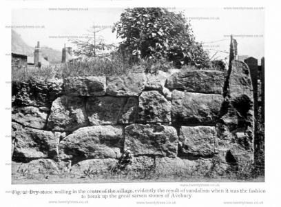
The fosse is bounded by a vallum of imposing height, of which more than three-quarters remain, many parts being well preserved. The mutilation of the rampart and ditch in places was caused chiefly by the building of the eastern half of the village, and the construction of roads which approach Avebury from four directions. Walls (see pl. XXXII, fig. 2) and houses, obviously built of the venerable stones, collected and cracked up for the purpose, meet one’s gaze at every turn4. Indeed, as Lord Avebury said in Pye/iistoric Times , ‘the pretty little village of Avebury, like some beautiful parasite, has grown up at the expense and in the midst of the ancient temple \
Note 1. Avreberie in Domesday.
Note 2. The stones of Avebury were first noticed by Aubrey in 1648-9, when he observed that Avebury far surpassed Stonehenge as a cathedral does a parish church.
Note 3. The site of ‘the Temple’ is on the outcrop of the Middle Chalk zone of Rhynchonella Cuvieri.
Note 4. The Rev. Bryan King said: ‘There are very few lineal yards which are not occupied by causeways, walls, and cottages, all formed of sarsen stone, sufficient, and more than sufficient, to absorb all the stones of the Beckhampton Avenue’ (Wilts. Arch. Mag. xviii, 377-83).
The immediate surroundings of Avebury are equally interesting, and in dealing with any one of these ancient sites it is natural that we should be constantly weighing its archaeological value with evidences of prehistoric date Irom the adjoining sites; and so the study of Avebury and its appendages and neighbouring ancient sites becomes rather complicated.
Ol the Kennet Avenue, which approaches Avebury from the SE., nineteen stones remained to be seen at the time of our excavations at Avebury. Stukeley, with Lord Winchelsea, counted seventy-two stones of the avenue in 1722 [ See Stukeley's Avebury Chapter 7] However, after Mr. A. Keiller's (age 44) extensive excavations here (begun in 1934), we shall be very much more enlightened with regard to details in the construction of this avenue.
Continuing farther to the SE. of Avebury we come to 'The Sanctuary ’ on Overton Hill representing the termination of the Kennet Avenue, where excavations were carried out in 1930 by Mr. and Mrs. B. H. Cunnington. Some of the pottery discovered is similar to that from the Avebury fosse—two distinct but overlapping types—the earlier the West Kennet or Peterborough longbarrow type (Neolithic B), the later the Beaker type. This seems to correspond with the later phase of Windmill Hill.
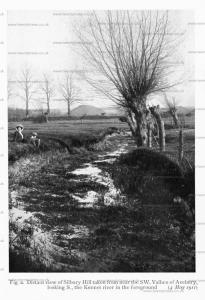
Proceeding westward, mention should be made of the West Kennet longbarrow, from which so much important pottery (Neolithic B) has been obtained. At a short distance NW. of the barrow Silbury Hill stands up boldly on the N. side of the Bath road, at a distance of about 4,750 ft. from the centre of the Avebury Great Circle, in a direction slightly W. of S. It is the largest artificial mound in Britain (pl. XXXIV, fig. 2). Since 1777 excavations have taken place there on several occasions, but the results have had little scientific value.1
Note 1. The perpendicular height of Silbury is 125 ft.; its diameter at base is from 552 to 555 ft.; circumference at base about 1,660 ft.; diameter at top 103 ft.; angle of elevation 30°.
Stukeley, in his work on ‘Abury’, published in 1743 [See Stukeley's Avebury Chapter 9], says: "In the month of March 1723, Mr. Halfold ordered some trees to be planted on the top of Silbury Hill, in the area of the plain 60 cubits in diameter .... The workmen dug up the body of the great king, there buried in the centre, very little below the surface."
In 1777 a shaft was sunk from the summit by the Duke of Northumberland and Col. Drax. It is to be iegretted that no detailed account of these operations is upon record; all that is known was published by Douglas in his Nenia Britannica , p. 161. In 1849 the base of the mound was tunnelled Irom the western isthmus on the south side of the hill. Two pieces of red-deer antler were found, and on the old surface fragments of a sort of string of two strands, each twisted. It is recorded that the Archaeological Institute came across the shaft 5 ft. by 4$ ft., previously sunk from the summit of the hill, as above mentioned. (Proc. Archcaeol. Inst., Salisbury vol, 1849, see papers by Dean Merewether and C. Tucker, 73-81, and 297-303; also Waylen’s History of Marlborough, 1854, pp. 405-8.)
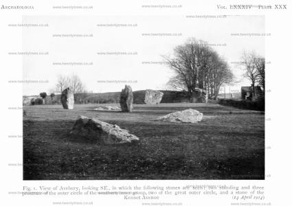
14 Apr 1014. Plate XXX. Fig. 1. View of Avebury, looking SE., in which the following stones are seen: two standing and three prostrate of the outer circle of the southern inner group, two of the great outer circle, and a stone of the Kennet Avenue.
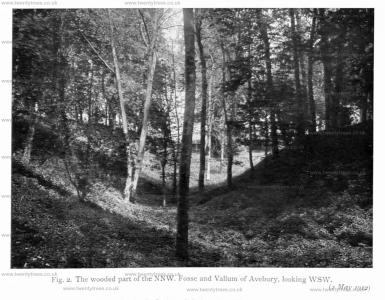
02 May 1912. Plate XXX. The wooded part of the NNW. Fosse and Vallum of Avebury, looking WSW.
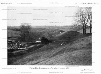
14 Apr 1914. Plate XXXI. Fig. 1. The E. earthworks of Avebury, looking NW.
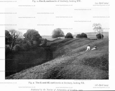
28 Apr 1914. Plate XXXI. Fig. 2. The E. and SE. earthworks at Avebury, looking NE. With Florence Harriet Young (age 38) and Lionel St George Gray (age 13).
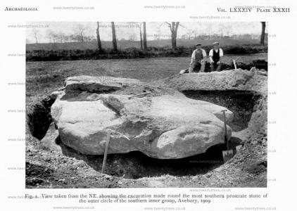
1909. Plate XXXII. Fig. 1. View taken from the NE. showing the excavation made round the most southern prostrate stone of the outer circle of the southern inner group, Avebury.
1935. Plate XXXII. 2. Dry-stone walling in the centre of the village, evidently the result ol vandalism when it was the fashion to break up the great sarsen stones of Avebury

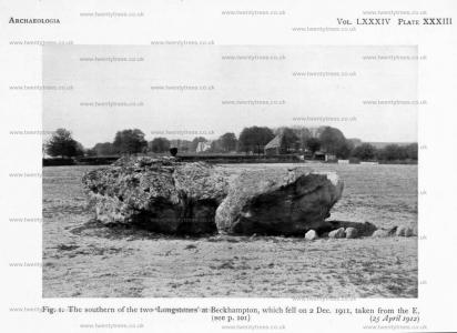
25 Apr 1912. Plate XXXIII. Fig. 1. The southern of the two ‘Longstones [Map]’ at Beckhampton, which fell on 2 Dec. 1911, taken from the E.
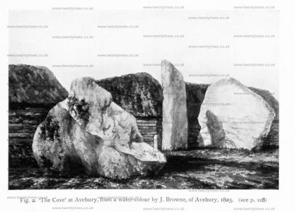
1825. Plate XXXIII. Fig. 2. ‘The Cove [Map]’ at Avebury, from a water-colour by J. Browne, of Avebury.
Proceeding round to the WSW., at a distance of nearly a mile from the centre of Avebury, we come to the ‘Longstone Cove [Map]’, ‘Longstones [Map]’, or ‘Devils Quoits [Map]’. Aubrey spoke of three upright stones, but two only remained in Stukeley’s time. They are now known as ‘Adam’ and ‘Eve ’, and stand about 95 ft. apart. At the end of 1911 ‘Adam’ fell, and when the Wiltshire Archaeological Society re-erected it a human skeleton and beaker, both in a fragmentary condition, were found, which must have been buried after the original erection of the stone. Some of the packing-stones are seen in the photograph of the monolith (pl. xxxiii, fig. 1); with them part of another beaker was found. The length of the stone was 17¾ ft., maximum width 15 ft. 4 in.; estimated weight, 62 tons.1
Note 1. Wilts. Arch. Mag. xxxviii, 1-11.

Coming round farther in the same direction we reach Windmill Hill [Map] on the NW., where Mr. A. Keiller (age 44) has investigated a part of the well-known Neolithic habitation, consisting of three interrupted ditches—the Inner, Middle, and Outer.
Finally, we will proceed back to Avebury via the Beckhampton Avenue. The Rev. A. C. Smith1 collected together the opinions of early writers as to the former existence, or non-existence, of the so-called Beckhampton Avenue. After mentioning Aubrey’s silence on the subject, he quotes the words of Stukeley at some length; then follow extracts from Thomas Twining, James Fergusson, and the Revs. C. Lucas, Bryan King, and W. C. Lukis.
‘There is no question that, if Stukeley’s word is to be believed, he most certainly saw many sarsen stones lying in two, more or less apparent lines west of the circle of Abury; moreover, he speaks of ten stones of this avenue known to have been standing within memory between the exit of the avenue from the vallum and the brook’ (Smith, p. 147).
Note 1. Wilts. Arch. Mag. xxxviii, 1-11.
In Stukeley’s published works there is no plan of this western avenue, but it has been found that the manuscript he left behind him1 includes a plan of the Beckhampton Avenue. It appears that thirty-four stones belonging to this avenue were in existence in 1720-4, all of which had then fallen except three (including 'Adam' and 'Eve').2 The total length of this avenue, according to Stukeley, was 7,000 ft.; therefore it must have extended about 2,000 ft. WSW. of the 'Longstones'.
Note 1. It is now generally known that Stukeley was most assiduous in the preservation of his various manuscript writings and drawings (‘Stukeley, Avebury and the Druids’, by S. Piggott (age 23), in Antiquity, ix, 22-32).
Note 2. Wiltshire Gazette, 3 Aug. 1922.
II. PREVIOUS EXCAVATIONS AT AVEBURY
Avebury has been the site of archaeological explorations at least on three former occasions, but in each case some of the relics have apparently been lost, and very little indeed from the great 'Temple’ is to be found in local or other museums.
In the first instance, excavations were conducted under the direction of the Wiltshire Archaeological and Natural History Society from 29 September to 5 October 18651. ‘Considerable researches’ were made by ‘sinking holes in many places, running trenches across certain spots, and tunnelling the large external mound.’ In the vicinity of ‘The Cove’, within the north circles no traces of a burial deposit were discovered. It is stated that just under the turf two or three fragments of British2 pottery were found, together with bones of sheep and a small piece of burnt micaceous sandstone. In digging close to the two large stones of ‘The Cove’, layers of blocks of sarsens, up to assize of 18 in across, were uncovered; 'they were evidently placed there, and rammed in for the purpose of propping the massive stones in their upright position.’ 'Black charred matter is recorded to have been found, and numerous chips ofsarsen. It was thought that fires had been lit here for the breaking up of the stones 'A good deal of British pottery and many animal bones were found in these holes, but no human bones whatever.’ To the SE. of ‘The Cove’ a low embankment was cut through from W. to E., the 'finds ’ being a portion of a stag’s horn and some fragments of pottery. An excavation was also made into the \V. face of the ENE. vallum, but nothing was found. Another was made on the SW. at a place where the vallum had been mutilated for the requirements of the modern village; only one fragment of pottery was found here. A third excavation into the vallum was made to the WN\V side of the W. gap without any result in the way of relics. The excavations made in all numbered fourteen, and the fragments of pottery brought to light from the deeper cuttings 'were invariably of the British type ’ This latter remark is very vague, and without seeing the pottery it would be unsafe to regard the sherds as being all prehistoric.
Note 1. Wilts. Arch. Mag. x, 209-16.
Note 2. The author of this paper has italicized the word 'British ’ in this paragraph.
Those responsible for the excavations of 1865 claim to have fairly upset James Fergusson’s view that Avebury was a vast graveyard, and that human bones would be disinterred if search were made.1
Note 1. Fergusson, Rude Stone Monuments, 72 seq.
When the Rev. W. C. Lukis was making a plan1 of Avebury in July and August. 1881, his colleague, the Rev. A. C. Smith, rector of Yatesbury, resolved to examine the ground with a hope of discovering some buried stones. This was carried out by five workmen, and the spots specially observed were the places where Aubrey and Stukeley showed that stones had stood. The result was that sixteen large sarsens of the outer circle were discovered, also two others in the northern inner group, some buried at a considerable depth. It was Mr. Smith’s opinion that these stones had been sunk deep in the ground by means of pits dug beneath them, doubtless to be no longer a hindrance to the plough or for other agricultural reasons. They were covered up again after Mr. Lukis had made his plan, the spots being marked by numbered pegs, all of which have now probably disappeared.
Note 1. This plan is pl. v in Smith’s Guide to the British and Roman Antiquities of the North Wiltshire Downs, 2nd edit., 1885.
Lukis and Smith also noted and planned several pits in which stones originally stood. Hoare noted eight of these depressions, but Smith and Lukis were able to add twenty-five others not previously recorded. This increased William Long’s table of stones in 1857 from twenty-nine to forty-seven. A number of these stones of Smith and Lukis were declared by Stukeley to have been demolished before he made his plan in 1724.
Smith did not find many relics during the work of 1881. Some years ago the Wiltshire Archaeological Society sent me for examination fifty fragments of pottery found by Mr. Smith, and now deposited in Devizes Museum. All of the sherds appeared to me to be post-Roman, mostly of Norman origin. There is certainly no fragment among them that can be definitely regarded as preRoman. It is all of the same general character as the pottery found in the British Association excavations in the S. fosse above a depth of 4-5 ft. from the surface.
From July 4th to 19th, 1894, excavations were made into the vallum and fosse on the SE. (pl. xxxi, fig. 2) at the expense of the then owner, Sir Henry B. Meux, Bart., under the general direction of his steward, the late Mr. E. C. Trepplin, and the immediate supervision of the late Mr. Thomas Leslie, also one of the officers of the estate. This excavation was 420 ft. from the nearest edge of the Marlborough Downs road, the measurement being made on the curve along the berm from the middle of the cutting. The cutting was 6 ft. wide according to the Wilts. Archaeol. Magazine; but it is shown as 8 ft. on the large plan (pl. XXIX), and 140 ft. in length. These dimensions were estimated from observation on the ground in 1908. At the close of the 1894 excavations a westerly extension in the digging was made (6 ft. wide) along the fosse.


The 'finds' consisted mostly of fragments of pottery, one or two worked bones, a few flint implements, animal bones, and red-deer antlers, some bearing evidence of having been used as picks. The latter were found in the vallum, having been thrown up in a damaged condition at the time of their being broken, viz. when the ditch was originally being excavated and the vallum built. Several antlers were found at 4-75 ft. below the summit of the rampart, protected by about half a dozen large blocks of chalk ; they were those of slain deer. At the foot of the inner slope of the vallum several pieces of red-deer antler (one piece 17½ in. long) were found near the surface, and in digging here a few flint flakes were also discovered.
Two pieces of worked bone were found between 11 and 12 ft. deep below the crest of the vallum. These are perhaps the 'one or two bits of worked bone, like fragments of paper-knives' mentioned in the Wiltshire Archaeol. Magazine.1
Note 1. xxxiii (1903-4), 103, where it is also stated that ‘one small piece of British pottery was found on the original surface beneath the vallum’. This digging is also barely mentioned in the same Magazine, xxviii, 81.
On the old turf line and just above it, Mr. Leslie's rough diary (which the writer has) records the finding of a worked rib-bone and several flints (some worked), a few scrapers, and a quantity of flakes. Several pieces of rough sarsen stone were also found on the old surface.
Mr. Leslie found what appeared to be the grass surface line of an inner rampart, defined by a curved band of vegetable mould measuring about 3½ in. in thickness.1 At about the middle of the inner slope, in one place, the soil of the old turf line was found to be nearly 2 ft. thick. It bore evident signs of having been burnt, and a quantity of wood ashes was noticed. It should be mentioned also that the old turf line in this cutting was said to be 2-25 ft. below the level of the adjoining field.
Note 1. In our cutting into the vallum in 1914 there was apparently no indication of an earlier vallum having been surmounted by additional material.
The fosse, apparently, did not reveal any important results, as the excavations were carried only to a depth of 7-5 ft. from the surface of the middle of the silting (about the depth at which the writer came to the upper margin of the chalk rubble in the southern fosse). It would appear, therefore, that when the white chalk rubble was reached, it was thought to be the floor of the fosse. Probably it was crystallized and almost impenetrable by the pick-axe, as the writer found in his later excavations into the fosse. Carbonate of lime had consolidated the chalk and rendered it nearly as hard as concrete, sometimes to a depth of nearly a foot. This would probably have been removed and the digging continued, had Mr. Leslie and those working w r ith him realized that they had not come to the true bottom of the fosse.
Mr. Leslie speaks of Romano-British pottery, which may probably be correct for the fragments found towards the bottom of his comparatively shallow digging, but he does not appear to have dug more than a foot or so into the pre-Roman strata of the silting. He does not speak of medieval pottery in his notes, but those pieces found above 4-5 ft. in the silting w'ould probably, on examination, prove to be post-Roman sherds.
The drawings, relics,1 and full notes, over which Mr. Leslie unfortunately had no control at the close of the digging, have for the most part been lost beyond recovery it is feared, a circumstance which minimizes the scientific value of the 1894 excavations very considerably.
Note 1. Two very large antler picks found in the excavations in 1894 were disposed of on 10 April 1915 at the Meux sale at Dauntsey House, near Swindon (lot 1258), and were acquired by the Wilt shire Archaeological Society for Devizes Museum.
III. THE EXCAVATIONS, 1908-1922
The excavations at Avebury, which are the subject of this report, were organized by the British Association. It was in 1899 that a committee was formed to deal with the subject of the ‘Age of Stone Circles’.1 In 1901 and 1902 excavations were conducted by the writer at Arbor Low in Derbyshire.2 In 1905 the Stripple Stones Circle in Cornwall was examined, and in that and the following year that circle and four others (the Trippet Stones, and the Leaze, Fernacre, and Stannon Circles), forming a group of five on Bodmin Moors, were surveyed.3
Note 1. The Committee consisted of Dr. J.G. Garson (Chairman), Mr. H. Balfour (Secretary), Sir John Evans, Mr. C. H. Read, Prof. R. Meldola, Mr. A. J. Evans, Dr. R. Munro, and Prof. W. Boyd Dawkins. In 1901 Mr. A. L. Lewis was added to the Committee. The two grants made by the British Association for the work at Arbor Low amounted to £50.
Note 2. Reports, British Assoc. 1901,427-40; 1902, 455-66; Archaeologia, lviii, 461-98; Journ. Derbysh. Arch. Soc. xxvi, 41-77.
Note 3. In 1905 Mr. C. H. Read became Chairman of the Committee. The Cornish work was recorded briefly in Repotis, Brit. Assoc. 1906, 370-82; and 1907, 368-73. A fuller and illustrated report is published in Archaeologia, Ixi, 1-60.
In 1908 some changes were made in the Committee,1 but Mr. Henry Balfour was still the painstaking secretary, and excavations began at Avebury, the work being continued in 1909, 1911, and 1914, and resumed finally in 1922.2
Note 1. In 1908 the Committee consisted of Mr. (afterwards Sir) C. H. Read (Chairman), Mr. H. Balfour (Secretary), Lord Avebury, Dr. J. G. Garson, Mr. (afterwards Sir) A. J. Evans, Dr. R. Munro, Prof, (afterwards Sir) W. Boyd Dawkins, and Mr. A. L. Lewis.
In 1909 Prof, (afterwards Sir) W. Ridgeway was added, and in 1912 Dr. G. A. Auden. In 1913 Lord Avebury died. In 1915 Prof. J. L. Myres and Mr. H. J. E. Peake joined the Committee. In 1922, after the war, the same Committee remained, but Mr. Lewis and Dr. Munro had died.
Note 2. Accounts, containing considerable detail, appeared in the Reports, Brit. Assoc., after each period of excavation, as follows: 1908, 401-11; 1909, 271-84; 1911, 141-52; 1915, 174-89; and 1922, 326-33.
Important departments in the work, besides the recording of the excavations, were the surveys (the large plan, the various sectional diagrams) and the series of photographs both ot the excavations and of the monument as a whole.
Some reference should be made to the financial conditions under which the work was carried out during those five short seasons of excavation at Avebury. Without considerable additional help it would have been impossible to employ up to a maximum of seventeen men from the total grants, viz. ^175, made by the British Association; and we take this opportunity of acknowledging the donations below mentioned which were subscribed towards this work.1 The total receipts were in the region of ^475.
Note 1. Society of Antiquaries, £32 25., Royal Archaeological Institute, £12 2s., Marlborough College Natural History Society, £25 155., Lord Abercromby, £55, Lord Avebury, £35, and the Hon. Henry R- Portman, £15, then there were contributions of from £5 to £10 each from Sir Arthur Evans, Dr W. M. Tapp, Mr. II. Balfour, the Druitt family, and the following, now deceased, Mr. Heward Bell, Lord Edmond Fitzmaurice, Sir Prior Goldney, Col. W. L. Morgan, and the fifth Marquess of Lansdowne. In smaller amounts the sum of £40 35. id was raised. Our thanks are due to Canon E. H. Goddard for having collected some of the Wiltshire donations.
We should also like to thank those who have rendered assistance in carrying out and recording the results of the Avebury excavations. Mr. Henry Balfour during the periods of work paid several visits to Avebury and took a keen interest in the details of the investigations. To Mrs. St. George Gray many thanks are due for assistance in the general organization of the work. Lieut.-Col. L. C. D. Jenner, C.M.G., D.S.O., the Rev. J. G. Ward, and Messrs. J. Peak-Garland, E. A. Parsons, and H. Lawes—landowners and tenants at Avebury—kindly rendered help in various ways. My foremen, Tom Paul of Glastonbury and the late John Lush of Dorchester, led the local labourers in praiseworthy fashion.
In connexion with the record we are grateful to Mr. Stuart Piggott (age 23) and Dr. Grahame Clark for their respective chapters on the pottery and the flint implements discovered. Thanks are also due to Mr. A. S. Kennard for his list of the mollusca, to Mr. J. Cecil Maby for identifying the charcoals, to Prof. W. Wright for his report on some of the human remains, and to Dr. Wilfrid Jackson for reading my report on the animal remains.
All the photographs and drawings (except those of the pottery and the fibula) are by the author of this report.
The finds,1 unless otherwise stated in this record, are now preserved in the Museum of the Wiltshire Archaeological Society at Devizes.
Note 1. They were numbered consecutively from no. i onwards covering the several seasons of work. Several of the numbers will not appear in this report as they refer only to modern and unimportant objects and to medieval and later sherds, but practically all the numbers will be found in the reports to the British Association.
IV. DESCRIPTION OF THE PLAN, PLATE XXIX
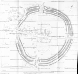
The greater part of the Avebury survey was made in 1912, from 19th April to 6th May.1 The plan was later completed to include the position of the cuttings made in 1922—the last season of this series of excavations.2 For the purposes of the survey forty-two poles bearing small flags were placed chiefly along the crest of the vallum at suitable distances.3
The original plan was drawn, for convenience of size, on six sheets of 'squared' paper, and later these drawings were mounted on linen. The scale adopted was 40 ft. to the inch, but the plan is here reduced to 60 ft. to the inch. The area enclosed by the marginal lines represents 71-45 acres. The fosse is generally recorded as enclosing 28½ acres.
The plan shows the approaches to ‘ the Temple ’ from Ivennet and Devizes on the south, Swindon on the north, the downs on the east, and Avebury Trusloe on the west. Near the junction of these roads the approximate position of the ‘ centre ’ of the Great Circle is shown, and a circle has been described having a diameter of 1,108 ft., indicating how much out of the true the great stones were placed.
The stones still standing are shaded, whereas the recumbent stones are shown merely in outline. Holes from which stones have been taken are represented in dotted outlines; only those seen on the ground by the writer have been indicated.4
Note 1. Owing to the large area to be surveyed in detail, the task was a heavy one, but I received some assistance from my wife and my son (aged eleven years). No excavations were undertaken that year.
In 1908 the Director-General of the Ordnance Surveys informed me that at Avebury the magnetic north was i6° 21' W. of true north, and the north point is shown accordingly.
Note 2. The drawing was not finally completed till January 1935.
Note 3. From these points cross-bearings were made with a prismatic compass, all points being checked by tape measurement.
A few small rings on the plan indicate the position in 1912 of certain large trees. The NW. vallum and fosse are wooded (pl. xxx, fig. 2). T.P. indicates ‘telegraph pole’.
Note 4. Others might perhaps be detected in the winter-time when the grass is at its shortest. Proper excavation will some day no doubt reveal all the socket-holes. My plan shows more of these depressions than are represented in the 25-in. O. Sheet xxvm. 10 (edition 1924).
At first the stones on my plan were numbered, but these have been deleted as being of little or no value.

The inner northern megalithic group shows the remains of a circle 320 ft.1 in diameter (a medial line being taken), enclosing the two standing-stones— part of 'the Cove'2 To the SE. of this we have shown on the plan the only buried stones exposed during these excavations; the digging was done in 1922 at the close of the work here described.3 This broken group of stones may be the recumbent stone opened out in 1865 by Smith and Cunnington.4
Note 1. Stukeley’s and Crocker’s plans give the diameter as 410 ft., while Lukis says ‘ not more than 270 ft.’
Note 2. The southern of the remaining stones is 17 ft. in height above the ground-level; it leaned in 1922 to the N. 33 in. out of the perpendicular; in 1881 there is a record that it overhung to the extent of 27^ in. The western stone is 14 ft. 7 in. in height, with a width of the same dimensions; in 1881 it overhung 15 in. The northern stone fell in 1713 and was broken up; it is said to have been 7 yards long.
Note 3. For some years the writer had known of part of a sarsen stone showing one or two inches above the surface in the farmyard near ‘the Cove’, and probing revealed the fact that it extended for some distance. Expecting that this stone might be of sufficient importance to mark on my plan, this area was dug over by two men. The stone proved to have been buried by penetrating the solid chalk for the purpose. In plan it measured 5.8 ft. in length by 4.5 ft. in width at the W. end; at the E. end it was 3.5 ft. wide; it was a stone apparently of almost quadrangular cross-section; its thickness at the W. end appeared to be 1.7 ft.
Extending the digging both N. and S., two other stones were uncovered, the most southern reaching the present surface at the W. end. The most northern stone was only 5 in. deep below the surface at the W. end ; at the E. end it was rather deeper. It was found that the three stones covered a length of 165 ft. The S. piece was triangular, 7.3 ft. in length, with a maximum width at the W. end of 62 ft., where the thickness of the block appeared to be 125 ft. The most northern stone was of more or less triangular shape, having a maximum length of 75 ft., and a maximum width of 4.15 ft.; thickness about 1.75 ft. The N. and middle pieces were only 0.35 ft., and the middle and S. pieces 0.75 ft. apart. The middle stone sloped eastwards at an angle of some 45°; the others were lying fairly flat.
These stones, which were covered up again at the wish of the owner, Mr. J. Peak-Garland, are to the E. of the two great standing-stones known as ‘the Cove’. The nearest parts of the N. and middle stones are about 29 ft. E. of the nearest or highest stone of ‘the Cove’.
It is surmised that these stones originally formed one large stone which might possibly be Stone ‘D’ of Hoare’s plan, buried in the position now found; if so, it formerly stood at a distance (according to Hoare) of 83 ft. from the nearest stone of ‘the Cove’.
In connexion with the position of stones in the vicinity of 'the Cove', the photograph of a water-colour by J. Browne of Avebury, dated 1825, here reproduced for the first time, will be of interest (pl. xxxiii, fig. 2). It appears here with the kind permission of Mr. Herbert Druitt of Christchurch Hants.
The drawing measures 10¼ in. by 6¾in., and the following contemporary information accompanies it: 'The Cove or place of Sacrifice in the Serpentine Temply at Abury. The stone to the right is that at the foot of which the Alter stone for the sacrifices was placed; the marks of fire are still upon it. A stone was originally placed to the left of it accordant with the central one to form the Cove. That to the left in the picture is one (stone) of the smaller circle around it.’
Note 4. Wilts. Arch. Mag. x, 212.

To judge from Stukeley s plan, etc., there can be little doubt that there was a concentric circle here within the larger circle, which is believed to have been about 170 ft. in diameter; but there is no trace of its former existence on the surface of the ground to-day.1
Note 1. We have ventured to dot in a circle on the plan, although its position may not be accurate by several feet.
It may be noted that the outer of the northern circles has only four stones showing at the present time—two standing and two prostrate. According to Stukeley’s plan there should originally have been twenty-nine stones in this circle, at an average distance of 30 ft. apart. A small segment of the southern part of the circle is represented to-day by a part of the village street; and the plan shows that the nearest points in this circle and the larger of the southern group are about 64.5 ft. apart.
The larger circle of the southern group has an approximate diameter of 336 ft.,1 and it is now represented by two standing and three prostrate stones on the S. and SW. (pl. xxx, fig. 1); also by seven depressions from which stones have been removed in the southern half of the circle. On the NW. the former position of another stone is indicated. There appear formerly to have been twenty-eight or twenty-nine stones in this circle, at an average distance of about 30 ft. apart.
Note 1. Stukeley’s and Crocker’s plans give the diameter as 410 ft., while Lukis makes the dimension 320 ft.

There is decided evidence of a smaller circle, about 154 ft. in medial diameter, in this group, and, judging from the position of the four stone-holes, it would appear to have been precisely concentric with the larger circle of the southern group.
The true centre of these mathematically accurate circles is marked by a decided depression from which the so-called ‘Obelisk [Map]’ was removed.1
Note 1. The Rev. A. C. Smith (North Wilts., p. 142) mentions an urn full of bones ‘found towards the centre of the southern temple in 1880’ by Mr. Pratt when he was sinking a hole for a flagstaff, on the occasion of a village fete in that field. The urn was broken to pieces, and the fragments carried off by the children.
This burial by cremation was probably deposited here considerably after the construction of the circles.
A traditional ‘sanctity’ still lingers round this spot.
Mention should be made of the position of the ‘Ring-stone [Map]’ which stood in Stukeley’s time. The centre of the depression marking the spot is 60 ft. S. of the southern outer circle, and 14 ft. W. of a line continued through the centre of the N. and S. groups of circles.
The plan also includes the only remaining standing-stone of the Kennet Avenue close to Avebury, at a distance of 280 it. SSE. oi the nearest point of the Great Outer Circle, to which we must now turn.
Bare allusion has already been made to the Great Outer Circle which follows the fosse on its inner side. We have put the approximate diameter at 1,108 ft., but it is considerably out of the true, and few of the stones actually touch the circumference of the circle described on the plan. The most accurately placed stones were in the NW. and SE. quadrants. There is much flattening (inwards) on the SW., a short flattening on the N., and a decided outward bulge on the N E.
With regard to the stones it is estimated that just over one hundred of these gigantic sarsens formerly occupied this ring, of which only nineteen are seen to-day ten standing and nine recumbent (some partly overgrown). The average distance apart was apparently in the region of 38 or 40 ft.
Ihe most southern part of the outer circle of the southern group is 134 ft. from the line of the Great Outer Circle to the S., whereas the most northern part of the outer circle of the northern group is 249 ft. from the nearest part of the Great Outer Circle to the north.
The plan further shows that the average diameter of the vallum (pl. xxxi, figs. 1, 2) measured from crest to crest is about 1,400 ft., and its circumference (measured along the crest) about 4,440 ft.


It remains to be said that the buildings indicated on the plan are those which existed in 1912. All were measured on the spot and not taken from the 25-inch O. Sheet. There are no buildings of great age within the earthwork, and the ancient church and manor-house are outside and well to the north of the western entrance approached by the Beckhampton Avenue.
1 he position of all the excavations is shown, viz. Cuttings I, II, III, VIII, and IX across the fosse; Cuttings IV, V, VI, and VII on the entrance causeway; and Cutting X through the vallum.1 Sir Henry Meux’s excavation into the fosse and vallum is outlined on the SE. quadrant; and an arrow points to Silbury Hill, the centre of which is 4,750 ft. a little W. of S. from the centre of the Great Outer Circle of Avebury. Plate XXXIV, fig. 2, shows Silbury taken from a field near the SW. vallum of Avebury, the Kennet stream in the foreground.
Note 1. The extent of the excavation on the N. and E. sides of the largest prostrate stone of the southern inner group is also indicated. See pp. 131-3, and fig. 5 for details.

CUTTING I, FOSSE
This cutting was 24 ft. long, as the plan, pl. XXIX, shows, and its most westerly margin was about 156 ft. from the middle of the hedge along the road approaching Avebury from the south. The main cutting was 37 ft. wide, but on the line of the sectional diagram (pl. XXXVI, fig. 1), taken on the line E.F. of plan, the width was 45 ft., in order that the profile of the fosse might be shown to the best advantage.

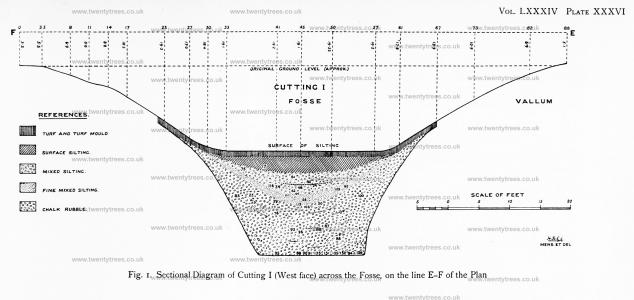
In plotting the sectional diagram it was found that the present surface of the silting of the fosse in this part was about 13.7 It. lower than the original ground level, viz. the level of the adjacent field in which the remains of the outer circle of stones are situated. It seemed rather remarkable that the Avebuiy fosse had not silted up to a greater extent.1
Note 1. We heard some reports that the fosse had been cultivated as arable land circa 1850-60, but were unable to substantiate those statements on making inquiries from inhabitants still living.
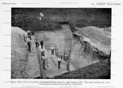
As it was anticipated that the fosse might prove to be deep, ledges had to be left in the silting at different stages to allow of the material being thrown up from the lower levels with comparative ease (pl. xxxv, figs. 1, 2); and it was found necessary in a large cutting of this sort to wheel out nearly all the material.
The turf and turf-mould were found to reach to a depth of 0.8 ft. ; in it several modern sherds and scraps of iron were found.1 A fine gritty mould came next, which has been called 'surface silting'.2 The average depth of this in the middle was 34 ft. from the surface, tapering off to both sides of the ditch. In removing this layer horizontally earlier deposits on the sides, viz. mixed silting and chalk rubble, were revealed. As will be seen by the diagram, the strata are deepest in the centre of the fosse, the surface of each deposit, as viewed from above, presenting a decidedly concave outline. The deeper a ditch, the more pronounced one expects to find this characteristic. Silting falling into an open ditch from either side naturally covers the profile very rapidly, and the surface of the silting as it increases from bottom to top is always concave, more so in the early stages of filling than later.
Note 1. At a depth of 1 ft. were found a farthing of William III, 1698, and a small Jacobean clay pipe.
Note 2. Within 3 ft. of the surface and below the turf-mould were found two oblong-headed horseshoe nails (no. 15), part of a horseshoe (no. 17), and tang and portion of a blade of a small iron knife (no. 75 ).
The next deposit—mixed silting—consisting of mould with a larger proportion of small pieces of chalk, extended to an average depth of 86 ft. in the middle of the silting. This deposit was also on the curve. In most places the bottom 2 ft. of this silting was found to be of a finer kind with a smaller admixture of bits of chalk, and it is differently represented in the diagram.
When the middle of the mixed silting was reached, the tracing of the hard chalk walls of the fosse on both sides to the depth we had excavated was proceeded with. This done, the work from day to day became temporarily checked by the caving in of parts of the vertical (or nearly vertical) face of the silting, sometimes two or three tons falling in one night. This is well seen in the photographs (pl. xxxv, figs. 1, 2). In the mixed silting, at depths of 5, 6.3, 6.3, and 7 ft. respectively, four sarsen boulders were found, each about 2 ft. across. In this deposit an iron medieval arrowhead, No. 56, was found.1
Note 1. It was picked up by a reliable excavator at a depth of 7.8 ft. below the surface. It is quite probable that a small pointed object like this might work its way down from its original position in the silting by means of rabbit and other holes to a much lower level. On the other hand, as the excavator had just begun a fresh ‘spit’, earth containing the arrowhead may have fallen from a higher level beforehand without revealing the object. However, no. 56 is shown in the diagram (pl. xxxvi, fig. 1) at the depth at which it was picked up.
The arrowhead has a socket of circular section; shank nearly straight and bevelled abruptly near the point where the cross-section is rhombic, length in. The late Viscount Dillon, P.S.A., said, 'The Avebury specimen is a medieval arrowhead of the “pile” class, and for use with the long bow. It is an interesting and rare example, but the actual date is quite uncertain.’ Vide also on Medieval Arrowheads, Gentlemans Mag. cii, 1832, pt. i, p. 114.


The mixed silting proved to be an interesting deposit as far as fragments of pottery were concerned, for there were three definite archaeological types. In the upper third, and above a depth of 4.5 ft. from the surface, Norman and medieval pottery1 was found commonly, indicating not only that Avebury was overrun during those times, but also that since early Norman times about 4.5 ft. of silting had accumulated in this part of the fosse. Secondly, pottery of the Roman period was found at depths varying from 5 to 6 ft. in the middle of the mixed silting deposit; and thirdly, two fragments of pottery (no. 44), belonging to the Peterborough ware — Beaker horizon — were found in the lowest third of the mixed silting at a depth of 7 ft. from the surface. In the middle division of this area twenty-five fragments of pottery were collected, all of Romano-British type and unornamented. Some of the pieces were small, and it is possible that a few of them may be post-Roman, but all undoubtedly are pre-Norman. The pieces of Roman ware associated with the Romano-British pottery consisted of a very thin fragment, brick-red on the two surfaces, light grey inside (no. 80, depth 5 ft.); a handle of a vessel of similar character (no. 109, depth 6 ft.); a fragment of thin grey pottery (no. 116, depth 57 ft.); a large piece of the side and neck of painted New Forest grey pottery painted a dull black on both surfaces (no. 98, depth 5.8 ft.); and a piece of tile, tegulum (no. 24, depth 5.4 ft.).
Note 1. Among these sherds is a large proportion of pieces of rims and bottoms of vessels; less frequently handles of pots were found, and fragments bearing definite traces of glaze. This pottery bears a close resemblance, both in quality, form, and general character, to that found in my excavations in the large camp known as ‘Castle Neroche’, 7 miles SSE. of Taunton (Proc . Som. Arch. Soc. xlix, ii, 23-53).
The coarse Bronze Age type of ware, containing grains of quartz, survived into Roman times, and is occasionally found with Romano-British sherds. But when found in deep deposits, unassociated with Romano-British pottery, it is generally safe to regard it as being of prehistoric manufacture. In this part of the Avebury fosse the highest pieces of the early type were found at least 12 ft. below the Romano-British type. The position of the various qualities of pottery in the mixed silting was most satisfactory as regards chronology.
To complete the account of the pottery from Cutting I it is necessary to turn to the vast accumulation of chalk rubble, from 8-6 ft. below the surface of the silting to the bottom of the fosse. The only fragments of pottery found in this deposit were three small pieces of prehistoric pottery described on p. 138. No. 25 was found at a depth of 7 ft.; no. 29 at 8 ft.; and no. 93 at 12.5 ft. There is no question about the depth of this last-named fragment, which was found in my presence by the foreman (who did all the important digging at low levels). All are shown in the section, pl. XXXVI, fig. 1, and, like no. 44, are apparently of late Neolithic date.1
Note 1. Two fragments of Romano-British pottery were found in the chalk rubble, but quite high up, close to the timer wall of the fosse, and as evidence of date their position was unimportant.

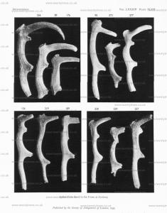
With one exception the other ‘finds’ in the chalk rubble were of little value as evidence of date. But that exception was an important one, viz. the finding of nine red deer antler picks (nos. 89, 90, 91, 94, 95, 131, 133, 135, and 136), for the most part fractured and incomplete, but capable of considerable repair,1 resting on the solid chalk floor of the fosse—thrown away when they became useless as tools (pl. XXXVI, fig. 1, and p. 150). Some of these picks proved to be excellent specimens, and nos. 89, 90, 133, 135, and 136 are figured in pls. XLVII and XLVIII. It is difficult to realize how this stupendous fosse was excavated out of the solid chalk by means of antler picks only. There can be no doubt that the hardest chalk must have been loosened, at least to some extent, by the blows ol flint hammers and mauls. The other appliances used in this work would probably be wooden and bone shovels, and baskets and ropes to haul the chalk to the surface. Close to the bottom a fragmentary shoulder-blade bone was found in a very bad state of preservation, and it was uncertain whether it had been used as a shovel.2
Note 1. All the picks and other antler and bone implements found in the Avebury excavations were restored by Mrs. St. George Gray (age 58).
Note 2. Three bone shovels, described on pp. 115-116, were found at the bottom of the fosse in Cutting II.

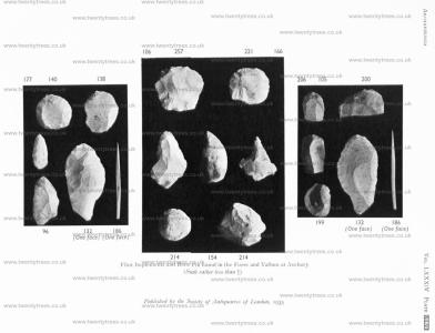
A flint knife (no. 96) was found at a depth of 13 ft. (pl. XLVI and pp. 142,143), and worked flint flakes at 7.3 ft. and 10 ft. (nos. 85 and 76). Another flint knife (no. 132) was found on the bottom of the fosse at a depth of 17 8 ft. below the surface. It is fully described on p. 143, and both faces of the implement are figured in pl. XLVI.1 A piece of human skull-bone (no. 87) was found at an approximate depth of 12 ft., and a human clavicle (no. 113) at a depth of 8.5 ft. See table, p. 148, for other human remains found in Cutting I.
Note 1. Other flint implements and flakes from Cutting I are recorded in the tables on pp. 143,145.
The chalk rubble covered the sides of the ditch up to the top; in the middle of the silting the deposit was reached at a maximum depth of 8-6 ft., and extended downwards to the floor of the fosse to a maximum depth of 17.6 ft., and a minimum depth of 16.7 ft., from the surface. The sectional diagram shows the depth as 16.8 ft. (pl. XXXVI, fig. 1). The clearing of the smooth, flat floor of the fosse was much impeded owing to the repeated falls from the upright face of the silting. However, after perseverance, a length of 17 ft. was cleared at the bottom, the length of the excavation on the surface being 24 ft. The average width of the bottom of the fosse was 16.7 ft.1 The inner wall of the fosse did not vary in slope very considerably, as seen by the diagram (inclination about 59 0 ), but the lower 5 ft. of the outer wall was very steep in most places (maximum inclination 8o°). No toolmarks were observable on the walls of the fosse, near the bottom or elsewhere.
Note 1. The width of the fosse at 5 ft. above the bottom was 21.5 ft. on the west; near the east, 20.5 ft.; and on the east, 22 ft.

THE SILTING IN CUTTING I
See sectional diagram, pl. XXXVI, fig. I.
(Dimensions taken in the middle of the silting)
1. Turf and turf-mould, thickness 0.8 ft.
2. Surface silting, average thickness 2-6 ft.; fine loamy silt of light-brown colour, without lumps of chalk, washed in and partly the result of denudation, but mostly derived from silt drained into the fosse from the roadway.
3. Mixed silting, average thickness 3.2 ft., consisting of rather darker loamy mould than the surface silting, and containing a fair proportion of small lumps of chalk from ¼-inch across to about 2 inches. On the W. side of the cutting a hard band of lumps of chalk was noticed across the middle of the stratum (seen in diagram, pl. xxxvi). Some of the lumps were 3 or 4 in. long, and resulted from a sudden fall of chalk from the profile of the fosse. This layer, 2 in. thick, was so hard that the foreman thought at first that the bottom of the fosse had been reached.
4. Fine mixed silting, average thickness 2 ft. A narrow, curved layer, consisting of fine chalk mixed with a small proportion of light yellowish-brown loam or mould.
5. Chalk rubble, maximum thickness 9.2 ft. The upper layers of this deposit consisted of rather small lumps of chalk seldom more than 3 in. across, and usually much smaller. Some of the pieces were found agglutinated as if by the lime contained in water which had percolated through the silting. The lumps of chalk were larger towards the bottom. Occasionally thin curved seams of mould were observed in this deposit, caused by the falling of turf and mould from the margins of the open fosse as it was gradually widening from natural causes, and by the deposit of surface mould thrown up undesignedly during the process of building the vallum and slipping back into the fosse.

VI. CUTTING II, FOSSE
At 87 ft. to the W. of the W. hedge of the road leading into Avebury, and at 69 ft. to the E. of the W. margin of Cutting I, another section was made across the silting of the fosse. This was Cutting II, which is, as the plan pl. xxix shows, like Cutting I, 24 ft. in length. Being nearer the road, which is on higher ground, it was obvious there would be a greater amount of surface silting to remove than in Cutting I.

In the endeavour to ascertain the extent of the fosse in this position, we caused several trial-holes to be made eastward of Cutting II to follow the upper margin of the walls of the fosse. This was satisfactory as far as it went, and it was found that instead of the fosse narrowing, it widened as it approached the hedge and road. This was as far as we could go in this inquiry until Cutting III across the fosse was tackled subsequently (p. 117).
As in Cutting I the new cutting was worked to a width of 37 ft. in most parts, but along the E. margin the width was increased to 46 ft. (see sectional diagrams, pl. xxxvii). The surface silting was found to extend to an average depth of 5-8 ft. in the middle. Nothing worthy of record1 was found in it, except a number of sherds of medieval pottery.2
Note 1. The ‘finds’ here included an Irish halfpenny of George III and a seventeenth-century tobacco-pipe of clay (maker’s mark, ‘Thomas Hunt’). The upper deposits had apparently been disturbed and further inquiries led me to believe that the surface soil in this part of the ditch had been cultivated up to the third quarter of the nineteenth century.
Note 2. No. 126 (marked in the section) is a piece of base and rim of an early medieval pot, with fingermark indentations round the edge of the bottom ; depth 3.2 ft.
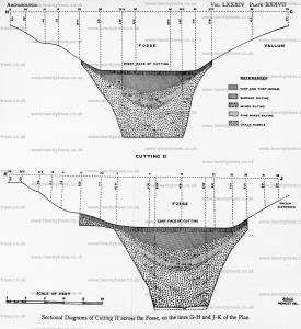
The next deposit, mixed silting, consisting of mould with a larger proportion of small pieces of chalk, extended to an average depth in the middle of 10.3 ft. from the surface. The lower part of this silting (thickness 1.7 ft. in the middle) was found to be of a finer kind with a smaller admixture of chalk.
Eight lots of Roman and Romano-British pottery were found in the mixed silting at depths varying from 5 ft. to 8 ft.1 One piece, no. 118, was picked up at a depth of 8.4 It., but it may have tumbled down during the digging. Several pieces of pottery ol early Bronze Age type, represented by nos. 119, 123, and 134, were also found in the mixed silting at depths between 8.5 ft. and 9.5 ft. and above the pure chalk rubble (see pp. 139-40). No. 123 is illustrated in fig. 6. This deposit also produced human remains (nos. 117, 122) in two places at a maximum depth of 9 ft. (p. 148). Four flint scrapers, nos. 106, no, 125, and 138 (pp. 143-4), were found in this silt at depths varying from 5.3 ft. to 9.5 ft.; nos. 106 and 138 are figured in pl. XLVI.
Note 1. As these eight lots are not mentioned elsewhere, a brief description will be given; it will be unnecessary to state the depth in each case as all the finds are marked in the sectional diagrams, pl. XXXVIII.
No. 101. Piece of hard grey Roman pottery, painted brick-red inside and out; thickness, 75mm.
No. 102. Fragment of thin Roman pottery, pale grey on the inner lace, brick-red on the outer.
No. 104. Part of base of a coarse brown pot; Romano-British.
No. 108. Small piece of red pottery of a smooth soft paste, Roman. Probably worked its way down through a hole into the upper part of chalk rubble.
No. 114. Several fragments of a lathe-turned vessel of brown ware of a very sandy texture, Romano-British.
No. 115. Three fragments of Roman vessels of different qualities; one of sandy texture like no. 114; another greyish-brown ware; the third a fragment of thin grey pottery painted brick-red on both sides
No. 118. Piece of thin grey ware, and a fragment of dark brown ware; Roman.
No. 130. Two pieces of Romano-British dark brown ware ot sandy texture like no. 114.

Between the mixed silting and the chalk rubble in the middle part of the silting, tapering in both directions, a seam of crystallized chalk, almost impenetrable to the pick-axe (indeed, it broke two points), was reached; it occurred at the same level in all the cuttings made. Carbonate of lime had consolidated the chalk and rendered it as solid as concrete, to a thickness of 1 ft. in places. The workmen considered it to be the bed of an ancient watercourse! In any case, there must have been a considerable amount of soakage of water to deposit carbonate of lime in such quantity.
Owing to the curvature of the stratum in the silting, the chalk rubble on the sides of the fosse extended almost to the top; in the middle it was reached at a depth averaging 10 ft. From here to the bottom, as elsewhere, silted chalk rubble only had to be removed with thin seams of mould caused by occasional falls of turf. A piece of pottery of the early Bronze Age type was found at a depth of 8.7 ft. near the southern margin of the fosse. No other pottery was discovered, but three pieces of worked Hint, nos 105, 112, and 146 (pp. 143-4), were found at depths between 6.5 ft. and 9.5 It. near the sides ol the fosse; no. 105 is illustrated in pl. XLVI.

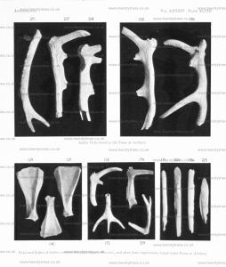
Two antler picks, nos. 124 and 128, were found on or close to the bottom of the fosse, depth 165 ft. and 188ft. respectively (p. 151). In Cutting I a fragmentary shoulderblade bone was found near the bottom of the ditch. In Cutting II three well-defined specimens of shovels (scapulae) were found, two (nos. 129 and 137) shoulder-blades of ox (Bos longifrons) being found on the floor of the fosse at depths of 18.5 It. and 18.8 ft respectively; the other (no. 145) was a scapula probably ol a young ox, found at a depth of 14.3 ft. in the chalk rubble, having apparently slipped down from the vallum before it became turf-clad. The two shovels, nos. 129 and 137, measure 13¾ in. and 12½ in. in length. In nos. 129 and 145 the anterior spine has been cut away, or partly removed, and from this fact and the worn appearance of these three specimens, together with the great scarcity of other animal remains except the antler picks at such a great depth, we regard it as more than probable that these scapulae were used as shovels in the original excavation and clearing of the fosse.1 The three specimens are illustrated in pl. XLVIII.2
Note 1. In Archaeologia, LXII, 113, the late Horace W. Sandars said, ‘Some doubt has been expressed as to whether scapulae were employed for such purposes (shovelling chalk), but further and con¬ vincing proof of such usage has recently been afforded by the investigations carried out by Mr. H. St. George Gray at Avebury, where similar implements in association with deer-horn picks have been found at the bottom of the deep ditch that surrounded the monument.’
Similar bone shovels have been found at Cissbury (one is figured in Anchaeologia, XLV, 345). But perhaps the most interesting are the five specimens found in the Harrow Hill flint-mines, 1924-5, and described by Drs. Eliot Curwen and E. Cecil Curwen in Sussex Archaeol. Coll., LXVII, 103-38; they include a unique example with the neck of the bone hollowed out by a deep tapering groove for the insertion of a handle (see illustrations in their paper, p. III). Dr. E. C. Curwen has also written some notes on the use of these scapulae as shovels (op. cit., 139-45). Portions of three worked shoulder-blades were found at All Cannings Cross: see Mrs. Cunnington’s book on the subject, pl. 10, figs. 1, 2, and pl. 14, fig. 3. A specimen was found in a flint-mine at Stoke Down, near Chichester, and is now in the Brighton Museum (Proc. Preh. Soc. E. Anglia, IV, 89).
Two shoulder-blades of somewhat similar character were found in the Glastonbury Lake Village; see the work on the subject by Dr. A. Bulleid and Mr. H. St. George Gray, II, 415. They have been found in rather large numbers in the excavations being conducted at the Meare Lake Village 4 miles W. of Glastonbury; a small proportion of them is ornamented.
Note 2. No. 129 is preserved in the British Museum, no. 137 at Devizes, and no. 145 in the Pitt-Rivers Museum at Oxford.

Plate XXXVII. Sectional Diagrams of Cutting II across the Fosse, on the lines G-H and J-K of the Plan

The bottom of this part of the fosse was just as smooth as in Cutting I, but it narrowed slightly. In Cutting I the width at the bottom varied from 16 ft. to 17.3 ft. In the W. half of Cutting II it varied from 11.8 ft. to 17 ft., and in the E. half it averaged 14.3 ft. The bottom was found to rise slightly towards the E., and along the E. margin a ridge (height about 0.9 ft.) of solid chalk crossed the fosse, as shown in one of the sectional diagrams, pl. XXXVII; in the middle of the ridge was a slight hollow.

The walls of the fosse in the lower parts became steeper and were very irregular, there being considerable projections of hard chalk left apparently for no particular purpose. We experienced no fall from the E. face of the silting, it being sloped as the excavation proceeded, finally to the extent of 4.5 ft. out of the vertical.
The depth of Cutting II from the surface of the silting on the W. was 18.8 ft.; on the E. 20.5 ft.; the difference was accounted for partly from the fact that the surface rises gradually towards the road.
The fossils from the fosse, both in this cutting and Cutting I, were all Inoceramus labiatus (Schloth.), except two, which were Rhynchonella Cuvieri. This supports the conclusion recently arrived at by H.M. Geological Survey that the occurrence of Inoceramus labiatus is proof of the zone of Rhynchonella Cuvieri.
A pebble, sent early in 1931 to the late Dr. H. H.Thomas, F.R.S., petrographer to the Geological Survey, was found at a depth of 55 ft. (stratum unrecorded). He wrote: ‘It is an unusual rock and I do not remember anything like it from Windmill Hill. It is compact and certainly water-worn. In cutting a small section from it I find that the rock is a decomposed porphyrite or andesite, probably of North Wales derivation. As, however, the specimen is probably a drift pebble, the original source means little.'
VII. CUTTING III, FOSSE
The E. edge of Cutting III was only 6 ft. W. of the W. margin of the hedge bounding the modern road into Avebury from the south. A length of 14 ft. of fosse was marked off for examination. It was close to the roadside gate, and was dug to ascertain if the fosse rounded off to form a solid entrance-causeway (see photograph, pl. XXXVIII, fig. 1).
Both Aubrey and Stukeley apparently show the position of the Kennet Avenue entrance into Avebury as being on the site of the present road, and this fact rather fed us to suppose that the fosse on the W. side of the solid entrance-causeway must have terminated in about the position of the present W. hedge. But our excavation into the fosse of Cutting III proved that their plans are incorrect and misleading.
In the previous year we made several trial-holes to ascertain the direction towards the E. taken by the upper margin of the walls of the fosse exposed in Cutting In a the holes nearest to Cutting II the solid chalk upper border of the fosse-wall was revealed; but instead of the fosse narrowing it widened as it approached the hedge and road.

Before excavating a part of the area called Cutting III we dug a trench about 32 It. long and 5 ft. wide, connecting the N. face of Cutting II with the N. face of Cu ting III, and clearly exposed the upper wall of the fosse. On the top of the solid chalk wall in the NNE. corner of Cutting II a slight platform was observed. It was found on excavation to continue a little towards the N„ but judging from (1) the apparent hollows in the turf-clad inner bank for some little distance round, and (2) the fact that modern sherds were found down to the solid chalk, it appeared evident that some rather recent digging had taken place here, perhaps for chalk, as in the much larger mutilation of the vallum opposite the south.
Having re-excavated Cutting III to a considerable depth we felt bound to complete the N. portion of it to the bottom, which the fine weather permitted us to do. It soon became clear in digging this cutting that the fosse approaching the causeway from the W. not only maintained the great depth, but expanded considerably towards the point where it rounded off to form the causeway under what is now the high road into Avebury (see plan, pl. XXIX).

The top margin of the fosse in Cutting III proved to be 52 ft. wide, and the whole of the filling to a depth of 5 ft. was removed. This produced no object of importance and consisted entirely of silt from the hedge and road, and a loamy tenacious material said by the local people to have been brought to this spot from the site of the 'New Bridge' across the Kennet stream on the Devizes road, a quarter of a mile SW. of our diggings, when it was built. It entailed much manual work to remove this 'dumped' material, but afterwards we came upon the same ancient deposits as occurred in Cuttings I and II, making ‘finds’ of pottery (nos. 142 and 143, p. 140),1 and obtaining a wellworn flint scraper (no. 140) at a depth of 9 5 It. in the mixed silting, which is illustrated in pl. XLVI. A flint core and another implement (nos. 147,141) were found in the same deposit, down to a depth of 12 5 ft. (p. 144).
Note 1. The sectional diagram (fig. 1) also shows the position of no. 139, part of a base of a medieval pot, depth 6 ft.; and no. 144, two small pieces of grey Roman pottery, depth 9.5 ft.
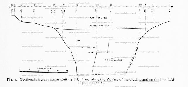

At length we reached the bottom at a depth of 23 ft. from the surface, but nothing of interest was found in the lowest depths, and no remains actually on the smooth floor of the fosse, which was exposed for a width of 8 ft. and a length of 3.8 ft. In no part of the excavations could one realize better the immensity of the great fosse and the labour its construction must have entailed when metals were practically unknown in Britain. The inner slope of Cutting III was perhaps the finest example of cut chalk exposed in any part of the excavations; and the uniformity of the slope and the absence of projections seemed to indicate that the fosse was originally excavated with greater care near the entrance-causeway than elsewhere. The average inclination of the fosse wall was at an angle of 63½° and covered a length of 26.5 ft. on the slope (see fig. 1); but the steepness of the profile in the lowest 6 ft. was remarkable, being at an angle of 81° the chalk resting in immense solid blocks in its natural condition. No ancient tool-marks were observable on the walls of the fosse, near the bottom or elsewhere.
VIII. CUTTING VIII, FOSSE
In many respects this fosse digging—the most westerly of our cuttings—was the most interesting. From it we were able to make various calculations as to ‘structure’ and the small ‘finds’ from here were among the most attractive.
Cutting VIII was 30 ft. long, and was afterwards extended in the middle 6 ft. farther W. in order that a ledge, or bench (length 10 ft.), might be cut, upon which the lower strata of silting could be thrown in clearing the bottom of the fosse. The E. margin of the cutting (in the middle of the silting) was 232 ft. in a direct line from the middle ot the gateway on the roadside close to Cutting III (plan, pl. XXIX), and 97.5 ft. from the middle of the W. margin of Cutting I across the fosse (see diagram, pl. XXXVI, fig. 2)

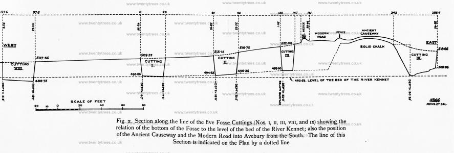
The surface of the silting at the point selected was fairly level (5 in. higher on the E than on the W. margin). It has been stated, on the authority of the oldest inhabitants of Avebury, that the whole of the S W. quarter of the fosse had been cultivated as arable land some eighty-five years ago, and this would account for the flatness here (pl. XL, fig. 1).
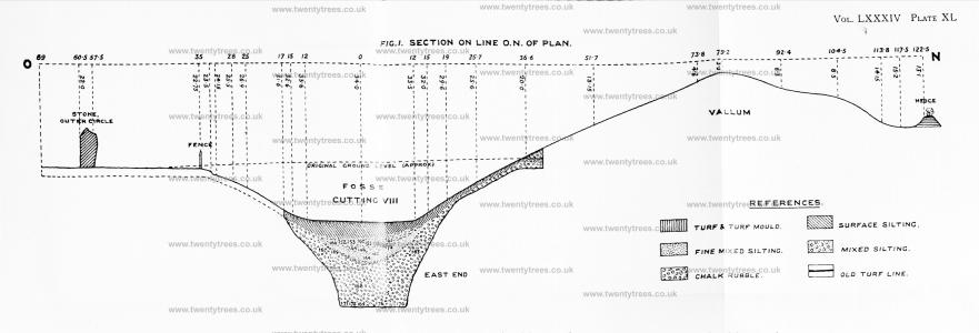
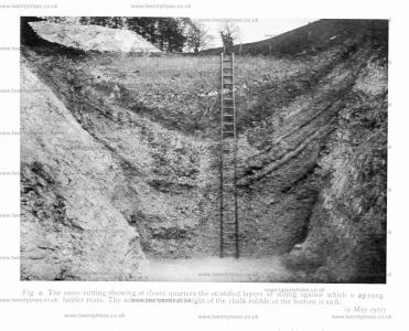
The upper deposits of silting at the E. end consisted, from the top downwards, of (1) turf and turf-mould, (2) surface silting, (3) mixed silting, and (4) fine mixed silting, their thickness being, in the middle of the accumulation 0.65, 3.35, 2.7, and 2 tt. respectively. This gave a total depth of silting above the chalk rubble of 8.7 ft. On the W. margin, where the fosse was shallower, these deposits were represented by a thickness of 7.7 ft. Dividing the surface silting from the mixed silting was a thin seam of small pieces of chalk which was traced nearly the whole way along the cutting. This feature is well seen in the photographs, pl. XXXIX, figs. 1, 2.

In the mixed silting some Roman remains were found, including an Aucissa fibula of bronze (no. 162), described and illustrated on pp. 155-7. At a depth of 4.7 ft. a small iron cleat, for shoe or sandal (no. 156), was found; it is 22 mm. in length, and has a narrow base (width 7.5 mm.) with the usual projecting points tor attachment.1 Scattered over a considerable area at a depth of 3.5 ft. part ot a black earthenware saucer (no. 161) of shallow type was found ; it has a bead rim.2
Note 1. These cleats are of frequent occurrence in Romano-British deposits; their use as portion of the iron furniture of sandals, or whose leather, is proved by the discovery of specimens, with a quantity of hob-nails, at the feet of skeletons at Rotherley and Bokerley Dyke. A specimen was fouind on the old surfaceline under the rampart of Wansdyke, a few miles S, of Avebury (Excavations in Cran bourne Chase, II, 190, III, 102, 106, 129, 270, &c.) Two specimens were discovered at Maumbury Rings (Proc. Dor. Field Clubv XXXI, 244)
Note 2. Other finds of Roman and Romano-British pottery were as follow:
No. 152. Fragment of soft cream-coloured New Forest ware, painted black and slightly ornamented ; depth 4.2 ft. near top of mixed silting.
No. 153. Fragment of brown pot ; found in similar position to no. 152.
No. 155. Two fragments of light brown pottery; depth 4.3 ft.
No. 158. Fragment of brown pottery, with slight striations ; depth 4.5 ft.
Part of a humerus and tibia, human, were found at a depth ot 4.5 ft. (p. 148); and pieces of red- and roe-deer antler were collected (nos. 149, 164, 172, and 174, p. 154 ).
At a depth of 5.7 ft a finely chipped flint knife (no. 154) was discovered, and is described on pp. 142, 144. and figured in pl. XLVI. The other flint implement was the scraper and awl (no. 166) (p. 144, and pl. XLVI)

In the mixed silting two distinct patches (not seams extending across the digging) of dark mould and very fine chalk were traced, the lower one practically throughout the length of the cutting at an average depth of about 7.2 ft. below the surlace. The higher patch was at a depth of from 5.4 ft to 6 ft., and extended northwards a couple of feet into the chalk rubble on the side. Each layer was 0.6 ft. in maximum thickness. Evidence of fire was distinctly traceable, and charcoal in small pieces was observed in both deposits. It is probable that these areas indicate occupation when the fosse had silted up to the respective levels.
In the lower patch we found a piece of the burr of a small red-deer antler, a piece of burnt bone, and fragmentary animal remains including those numbered 160, viz. part of the beam of a shed antler of red-deer, with burr, brow- and bez-tines complete; part of a dog's jaw, and a boar's tusk. The prehistoric pottery (no. 167) was found in the upper deposit of burnt material, in chalk rubble, depth 6 ft., associated with several bits of burnt bone and pieces of burnt iron pyrites. Seeing the importance of this ornamented pottery we had all the burnt material passed through a sieve. This pottery is of typical Neolithic B (Peterborough) type, and is described on p. 138, and illustrated in fig. 7.
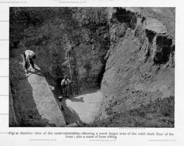
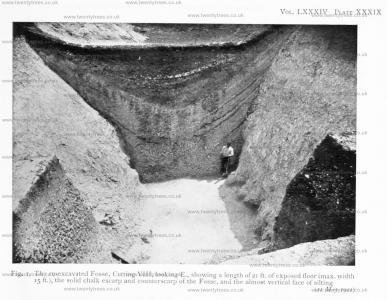
The chalk rubble was found, as in the other cuttings, to cover the solid faces of the fosse (well seen in the photographs, pl. XXXIX, figs. 1, 2, and pl. XXXIV, fig. 1), and its accumulation must have been very rapid when the ditch first fell into neglect. Relics found in this deposit would probably all belong to the first decade or so following the disuse of the monument.1 This silting was no doubt the result of natural causes, i.e. the scaling of the profile of the fosse in frosty and rainy weather, and the slipping down of the loose rubble forming the vallum, which in all probability was not at that time turf-clad. Comparatively small quantities of turf and mould would, in the course of construction, be thrown up with the chalk to form the great vallum, and the occasional fall of the dark mould from the bank would be sufficient to account for the concave streaks, or seams, in the chalk rubble of the fosse, which were even better defined in this cutting than in the sections previously made (see photographs, pl. XXXIX, figs. 1, 2). The lowest seam of mould met with, which extended right across the cutting in one part, reached at the point of greatest concavity to within 5 ft. of the bottom of the fosse. Four seams on the S. side of the silting were, for a length of several feet, exceptionally noticeable.2 On the E. margin the depth of chalk rubble in the middle of the fosse was 10 ft. This rubble was somewhat larger at about 2.5 ft. from the bottom, especially in the middle of the ditch, but it became rather smaller again on the bottom. Pieces of iron pyrites were commonly found in the rubble, but very little flint was observed, and most of the pieces were very small. Fragments of charcoal were occasionally met with. At the top of this deposit the lumps of chalk were found cemented together—no doubt caused by means of carbonate of lime contained in water which had percolated through the upper silting. The thickness of this consolidation was perhaps hardly as great as in Cuttings I and II.
Note 1. When the whole profile of the fosse became covered by chalk rubble the remainder of the silting must have accumulated in a decidedly decreasing ratio. The upper stratified layers, which are of a sedimentary character and much finer than the chalk rubble below, must have been deposited by wind blowing material into the fosse, and also produced by rain.
Note 2. See similar seams of mould in the fosse of Wor Barrow, Handley, Dorset (Excavations in Cranborne Chase, iv, pl. 250, 251, which the writer drew for General Pitt-Rivers many years ago).

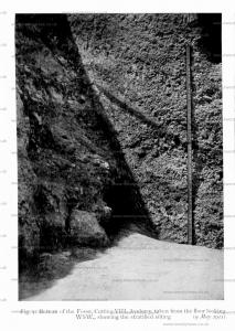
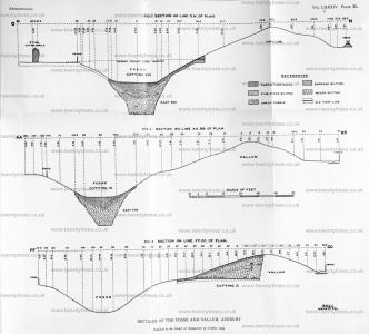
High up in the chalk rubble Neolithic B (Peterborough) ware was found in two places, see nos. 163 and 167 (mentioned above) in the sectional diagram on line O.N. of plan (pl. XL). This interesting pottery has been described by Mr. Stuart Piggott (age 23) on p. 138, and is illustrated in fig. 7, p. 139. No pottery was found in this cutting at a lower level.
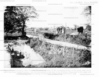
1909. Plate XXXVIII. Fig. 1. View of Avebury, taken from the S., showing some of the remaining stones of the great outer circle and of the inner southern group : also the excavations on the site of the Entrance Causeway on the right, and in the foreground the silting of Cutting III, Fosse, being removed in 1909.
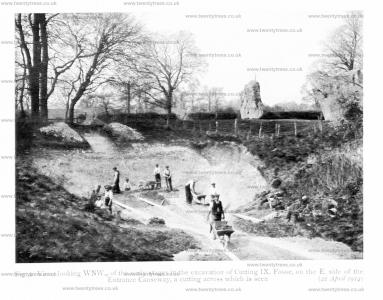
22 Apr 1914. Plate XXXVIII. Fig. 2. View, looking WNW., of the early stages in the excavation of Cutting IX, Fosse, on the E. side of the Entrance Causeway, a cutting across which is seen.
11 May 1911. Plate XXXIX. Fig. 1. The re-excavated Fosse, Cutting VIII, looking E., showing a length of 21 ft. of exposed floor (max. width 15 ft.), the solid chalk escarp and counterscarp of the Fosse, and the almost vertical face of silting.

09 May 1911. Plate XXXIX. Fig. 2. The same cutting showing at closer quarters the stratified layers of silting against which a 23-rung ladder rests. The minimum vertical height of the chalk rubble at the bottom is 10 ft.

A flat and rounded disc of impure sandstone (no. 159), water-worn into pebble-form, was found in the rubble, depth 6.8 ft.; it shows signs of fire at one end apparently, but the flaking might be due to other causes. No flint implements were discovered in this part of the silting.
A shed antler of red-deer (no. 170), of medium size, was found on the floor of the fosse near the S. margin; the brow- and bez-tines were broken off; total length in direct line 22 in. Two antler picks, nos. 175 and 176, described on p. 151, were in the same deposit; the latter is figured in pls. XLVII and XLVIII. An excellent specimen of a rake, no. 172, consisting of the crown of an antler of red deer, with three points or surroyals, bearing evidence of wear (pl. XLVIII) was also uncovered on the bottom of the fosse.


An animal’s rib-bone, no. 171, was found on the floor of the E. half of this cutting against the N. face. It has been worked to a rounded termination at one end, where it is very smooth—slightly bevelled from one side. Another, no. 176a, worked in a similar manner, but damaged at the ‘business-end’, was found on the bottom of the W. margin of the cutting. Both of them are illustrated in pl. xlviii. Two similar worked ribbones were found near the bottom of the fosse, Cutting IX (p. 127).

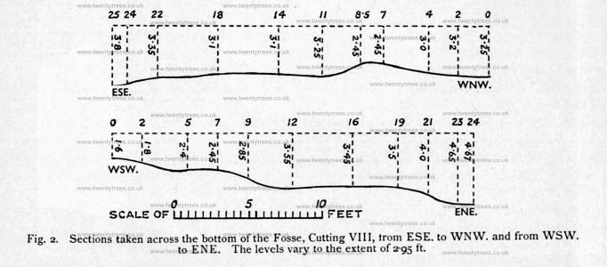
This cutting was 30 ft. long at the top, but as a considerable batter to the faces of the silting had to be left to avoid any risk of falls, it was only possible to uncover completely a length of 21.5 ft. of the floor. Unlike the floor in Cuttings I, II, and III, the bottom was found to be very irregular and far from level. Its maximum width was 15 ft. at the E. end, and the minimum width in the middle about 9.5 ft.
Two sectional diagrams of the floor were made (fig. 2), showing that the levels taken varied to the extent of 2.95 ft. This may probably be accounted for by the poor quality of the rock in this position, which consisted of a soft, smooth, rotten, pale greenish-grey chalk of the zone of Rhynchonella Cuvieri. The common fossil, R. Cuvieri, was found close to the floor. This poor chalk occurred also in the lowest part of the profile of the fosse, with occasional solid blocks of whiter chalk projecting beyond it, as seen in the photographs, pl. XXXIV, fig. 1, and pl. XXXIX, figs. 1, 2.


On the line of section O.N. (pl. xl, fig. 1) both the escarp and the counterscarp of the fosse, revealed by the removal of all the silting, had faces inclined at different angles. The following was the inclination of the chalk sides: Escarp, lower 5 ft., inclination, 90° ; middle 18 ft., 62°; upper part, 28°; Counterscarp, lower 8 ft., inclination 74°; middle 12 ft., 50°; upper part, 28°.

The fosse in Cutting VIII was deepest along the E. margin, viz. 18.7 ft. below the surface of the silting. It gradually rose as the work of re-excavation was continued westward. The depth of the fosse below the surface of the silting along the W. margin of the cutting was: maximum, 16.8 ft.; minimum (in the S. corner), 15.3 ft.; in the middle of the fosse, 16.3 ft.
While the excavations were in progress a sectional diagram (pl. XL, fig. 1) was plotted along the E. margin of Cutting VIII, and continued in a SSW. direction to include the crest of the vallum, the foot of the exterior slope, and the boundary-hedge beyond, and in a NNE. direction to cover the turf-clad counterscarp of the fosse and a small part of the central plateau, including one of the sarsen standing-stones (height 8.5 ft.) of the great outer circle.1 The horizontal distance from the N. side of the stone to the N. upper margin of the boundary-hedge was 183 ft., and from the middle of the fosse to the crest of the vallum about 78 ft.
Note 1. Between this stone and the field-fence to the SW. a small excavation was made to test the depth of the solid chalk, which was found to be 1.95 ft. below the field-level. The material above it was surface mould 0.75 ft.; the rest, mixed rubble.

This section showed that the central plateau was 12 ft., and the crest of the vallum 31 ft. above the turf level of the fosse. After re-excavating the fosse the bottom was found to be 18.7 ft. deep below the surface of the silting on the E. margin, and consequently 49.7 ft. below the crest of the vallum. Supposing that the crest of the vallum was originally about 5 ft. higher, the total vertical height from the floor of the fosse to the summit of the embankment would not have been less than 55 ft.
Along the line of section on the E. margin of the cutting a narrow trench (3 ft. wide) was dug from the S. side towards the crest of the vallum, to ascertain the position of the hewn chalk. It was found to run at an angle of 28° for a considerable distance, at a depth of from 11 to 16 ft. below the surface of the turf. This digging was carried for enough (20 ft.) to find clear traces of the old turf-line under the great vallum, and to reach the solid chalk at a depth of about 2.2 ft. below its surface. From this trench and the level of the central plateau, we were able to obtain a fairly accurate estimate of the original depth of the fosse in this part, that is its depth below the ground level at the time of the construction of Avebury. This estimate gives the depth of 31.5 ft. for the fosse in the middle, and a height (measured from the same point) of about 18.2 ft. for the vallum above the old surface line at the present time; but the original height of the embankment, as previously suggested, was no doubt greater.
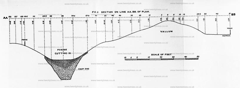
1912. Sections of the Fosse and Vallum, Avebury.


IX. CUTTING IX, FOSSE
This cutting was begun in 1914 and completed in 1922—the Great War having caused a long cessation of activities at Avebury.
The fosse excavation marked out for examination measured 44.5 ft. in length, and was situated on the E. side and against the solid chalk causeway (see plans, pl. XXIX and pl. XLIII, fig. 3). The width of the cutting was regulated by the line taken by the escarp and counterscarp of the fosse.

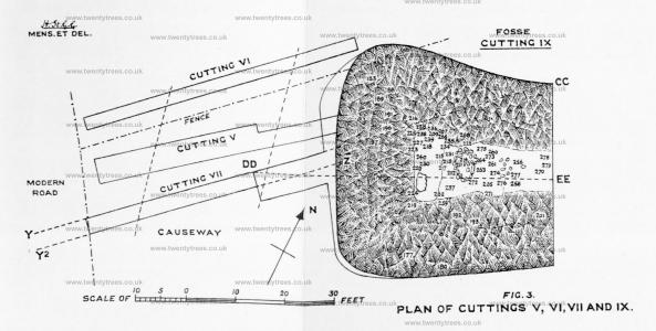
The crest of the vallum in the position of the E. end of Cutting IX is about 31.5 ft. higher than the surface of the silting of the fosse, and the latter is 14 ft. below the central area (outer circle). There is a decided berm1 between the fosse and vallum in the position of Cutting IX (see sectional diagram on line AA.BB. of plan, pl. XL, fig. 2).
