The Ancient History of Wiltshire Volume 2 Chapter 4 Avebury
The Ancient History of Wiltshire Volume 2 Chapter 4 Avebury is in The Ancient History of Wiltshire by Richard Colt Hoare Volume 2.
For the more perfect comprehension of the Places which illustrate the CHOROGRAPHY of Abury, and its environs, I have subjoined the following description:
1812. Plate X. represents the situation of the Temple at Abury, with its two extending avenues; Silbury hill [Map], the principal source of the river Kennet, the British track-way, groups of barrows, and the line of Roman road between Bath and Marlborough. This Plate may be considered as one of the most interesting views which our island can produce. It unites monuments of the earliest British and Roman antiquity, and will, I trust, convey a more correct and explicit idea of Abury and its environs, than any that has heretofore been given. The Plate No. VIII of Stukeley, is both confused and incorrect, because not drawn from actual survey.
On examining this ground plan, we perceive a degree of symmetry, of which, except upon paper, we could form no conception, nor for which could we give credit to the early Britons. We behold the grand circle placed in the centre of the picture, and the huge mount of Silbury in a line opposite to it1. Two avenues, like wings, expand themselves to the right and left, as if to protect the hallowed sanctuary, and the holy mount. The eastern avenue, terminates with a circular temple [Map], thus distinguishing it as a place of peculiar eminence. From the winding form of this work, Dr. Stukeley has very ingeniously developed the form of a serpent, and distinguished this temple as one of that class called by the ancients Dracontia.
This plan receives additional interest by comprehending same groups of barrows, which I investigated, the principal source of the river Kennet, a small portion of the British Track-way, passing from the district of South Wiltshire, throughout the whole extent of Berkshire2, and a large portion of the Roman road between Bath and Marlborough.
Note 1. Dr. Stukeley remarks that the meridian line passed through the centre of the Grand Circle, and of Silbury Hill; and on making our observations, and allowing for the variation of the compass, we find it still does the same.
Note 2. The course of this ridge-way has already been described, page 45. still does the same.
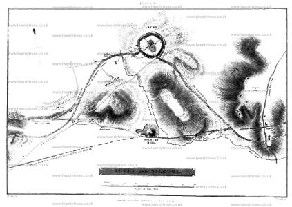
Plate Xl. By this plan I have been anxious to convey to my readers, correct idea of the grand circle at Abury in its original state, as most ingeniously developed by Dr. Stukeley. The site of the temples is taken from nature. The fine British earth-work called Oldbury Castle, appears at a distance in the centre of the view. The object of this Plate is to indicate the respective site of each temple; and the number of stones with which each composed; thirty in the out-ward, and twelve in the inner circles. The one situated towards the north, or right hand side, had three large upright stones in the centre of its area, designating the COVE [Map], where the altar was placed. The centre of the Southern Temple was marked by an upright stone named the OBELISK [Map], in a line with which, and between the temple and the outward circumvallation, was another single stone, with a perforation in it and denominated by Stukeley, the RING STONE [Map]. To this he supposes the victim was fastened previous to its sacrifice. The stones that accompanied the outward circumvallation, amounted to one hundred. The breaks in the vallum A. [Map] B. [Map] point out the spots where the two avenues issued from the central Temple; the one on the left side leading to Kennet; the other towards the centre to Beckhampton.
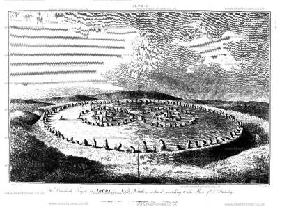
Plate XII represents a ground plan of the Grand Circle at Abury, taken by Dr. Stukeley (age 36) in the year 1724.; but from the inaccuracy of its outline, and the position of the two concentric temples, I doubt whether this plan was taken from actual survey1. It is, however, particularly interesting to the present age, as recording the state the circle at, a distant period, when it appears to have had eighteen stones standing, and twenty-seven fallen of the outward circumvallation; two standing, and nine fallen of the outward circle of the Northern Temple; one standing, and five fallen of the Inner Circle, and two out of three large upright stones that formed the COVE [Map]. Of the adjoining Southern Temple, four stones of the outward circle were standing in their original situation, and seven were fallen down; but one stone alone remained standing of the interior circle.
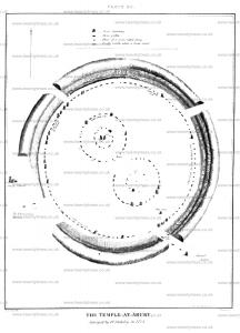
Plate XIII. From our own accurate survey made in 1812, we shall at once be convinced of Dr. Stukeley's error, in making this work completely circular and symmetrical, and in position he has given to the concentric temples within it. I have no doubt but the original British constructors of this work had the circular form in view, though they did not possess the mathematical means of drawing it to a nicety. You will observe also, that Dr. Stukeley has inclined the temples more towards the east than they in reality do. We differ also materially in the admeasurements of the area within the ditch, which the Doctor makes amount to twenty acres; we to twenty-eight acres and twenty-seven perch. We differ also in the circumvallation and diameter of the grand circle; the former of which he measured in 1721, with the celebrated antiquary Roger Calc, and calculated the compass of it, on the outside, at 4800 feet. Our measurement taken on the ridge of the vallum amounts to 4442 feet. The learned Doctor is rather confused in his measure of the area included within the rampart; for in onc place he states the diameter at 1300, and in another at 1400 feet. The farmer number agrees the best with our own measurement, which, in the broadest part of the work, amounts to 1260 feet from A to B, and 1170 feet from c to D. Owing to the numerous buildings and enclosed fields within the area, it is impossible to make as correct measurements as we could wish. Those, however, laid down in this ground plan have been made with every possible attention, and will fully prove that this work was not so symmetrically regular in its constituent parts, as the learned Doctor has described it.
Note 1. Mr. Aubrey says he, made the admeasuremeat of the works at Abury by a plane table, an old but correct mode of survey; and on comparing his pian with ours, I find a great resemblance between them; the lines of his circumvallation are irregular, but still aiming at a circle; the stones also that form the concentric temples, aim at the same form, but still are not placed regularly, according to Stukeley's plan; which is by no means so well suited to the British character as the idea we may entertain of the nature of this work, by the irregularity which is delineated by Aubrey.
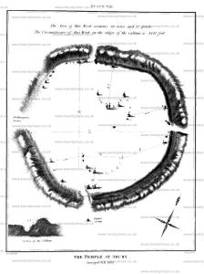
From the stones still existing in their original position, I have been enabled to ascertain the following measurements.
From the COVE of the Northern temple A. to a stone in the outward circumvallation C. is 354 feet six inches.
From the same stone A. to another in the outward circle of the temple F. 136 feet; and from the stone in the COVE B. to one in the inner circle D. 83 feet.
From another stone G. in the outward circle of this temple, we find the distance from it to a stone in the circumvallation to be 364 feet.
There are, unfortunately, no stones remaining in a situation to point out the intermediate space between the North and South temples but from the stone I. in the outward circle of the Southern temple, to the cavity of a former stone 1. we may fix the diameter of this temple at 325 feet; and the intermediate space between the cavity and the fallen stone of the circumvallation K. at 357 feet, and to the edge of the ditch 375 feet. The stone N. of the Southern temple, and the stone O. of the circumvallation are only 144 feet asunder, whereas those marked I. and K. are 357 feet apart.
These remarks will tend to prove the irregularity of the work; and it ought to be observed, that the two concentric temples are not placed exactly in the centre of the area of the grand circle, but incline rather towards the west.
Another peculiarity attends this work, will be explained by a reference to the section at the bottom of Plate XIII. I. have before mentioned the variation made use of by our British ancestors, in the construction of earth-works, formed either for religious or military purposes: the former having the ditch within the work; the latter on the outside. Abury and Marden may be adduced as splendid examples of the former, and the numerous camps which I have had surveyed and engraved, will testify the latter custom. But at Abury wee observe the singularity of a flat ledge, twelve feet wide, projecting from the vallum about half-way between it and the ditch. This was, probably, intended for the accommodation of sitting, to the numerous spectators who resorted hither to the public festivals. What a grand and imposing spectacle must so extensive and elevated an amphitheatre have presented, the vallum and its declivities lined with spectators; whilst the hallowed area was reserved for the officiating Druids, and perhaps the higher order of the people!
To render the illustration of this singular relict of British antiquity more complete, I have added a series of smaller Plates.
Plate XIV. No. 1. This view which is taken from the vallum of Abury, looking north-west towards the village of Monkton, wili point out the farm of this huge rampart; and the only stone remaining within the compass of this view, will indicate the nature of the outward circumvallation. A road leading from Abury to Oxford intersects the vallum in a line from north to south.
Plate XIV. No 2. This is the most perfect view that can, alas! be at present obtained of this mighty work. It represents two upright, and three fallen stones of the outward circle of the Southern temple. Beyond them, are two stones of the outward circumvallation; near them is the turnpike house; and beyond it one of the stones which formed the commencement of the Kennet avenue.
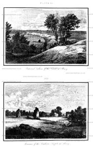
Plate XV. The view (No. 1.) is taken from the vicinity of a very fine bell-shaped barrow, on Hackpen hill, from whence you look down upon Abury, and may distinguish on the left side of the view the most entire part of the Kennet avenue.
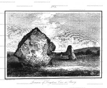
No. 2. represents the only two stones remaining of Longstone Cove [Map], with the village of Abury behind them.
Having described the Præcinctus and contents of the grand circle, containing two minor circles of unhewen stones, I shall now proceed to a description of the appendant parts, as noticed by Doctor Stukeley. The body of the Snake being explained, I shall follow the track along its neck towards the head, The Kennet avenue was intended co represent the neck of the sacred reptile, and may be considered as a Via sacra, leading up to the religious mount, by which its head was designated. The Doctor has the sole merit of unraveling this mystic form although his predecessor in antiquities, Mr. Aubrey, has mentioned the avenue as a "solemne walke leading from Kynet to a monument upon the top of the hill," he has not hinted at the supposed design, nor alluded to any connection between it and the grand temple at Abury.
"The Druids, says Stukeley, in iaying down this design, that it might produce a magnificent effect suitable to so great and operose a work, studied the thing well. As this was to be a huge picture, or representation of an animal, they purposed to follow nature's drawing as far as possible. A snake's body has some variation in its thickness, as slenderer towards the neck than at its middle. This the Druids imitated in making the avenue broader towards Southern entrance of Abilty, and drawing it nanower as it approached Overton hill. Again; when a snake is represented in its sinuous motion, the intervals of the stones sideways must have a variation, as set in the inner or outward curve, so as to make them stand regularly opposite to one another; yet this necessarily makes some little difference in the intervals, and this too is properly regarded in the work.
KENNET AVENUE. "The whole length of this avenue consists of a hundred stones on each side, reaching from the vallum of Abury town to the circular work on Overton hill. Measuring the breadth of it in several places, where I had the opportunity of two opposite stones being left, I found a difference, and the like by measuring the incervral of the stones side-ways; yet there was the same proportion observed between breadth and interval, which I found to be as two to three: so that here by Abury town, in that part which represented the belly of the snake, the breadth of the avenue was thirty-four cubits, ( fifty-six feet and a half,) and the intervals of the stones sideways, fifty cubits, (eighty-six feet, five inches and a half) the proportion of two to three, twice seventeen being thirty-four; thrice seventeen, fifty. These thirty-four cubits (or fifty-six feet and a half) take in the entire space of two intervals of the stones of the outer great circle of the Temple of Abury within the ditch, together with thc intermediate stone which is the entry of the avenue to the Temple. When we mount up Overton hill, the avenue grows much narrower; and this observation helped me in the discovery of the purport and design of the whole figure of the Snake, and in the nature of the scheme thereof."1
"When abode here for some time on purpose for several summers together, I was very careful in tracing it out, knew the distinct number of each stone remaining, and where every one stood that was wanting, which often surprised the country people, who remembered them left on the ground or standing, and told me who had carried them away.
Note 1. Two stones now only remain opposite to each other in the Kennet avenue, by which I am enabled to give the distance between them, which was fifty-one feet. The breadth lessens as it approaches towards the head of the Snake, and increases as it approaches towards tho body. The lateral distances between the stones of this avenue are more equal than I expected, being upon an average seventy-three feet asunder, the broad sides being placed facing the avenue. H.
"As to the stones that composed this avenue, they were of all shapes, sizes and height that happened, altogether rude. Some we measured six feet thick, sixteen in circumference. If of a flattish make, the broadest dimension was set in the line of the avenue, and the most sightly side of the stone inward. The founders were sensible that all the effect desired in the case, was their bulk and regular station. When the avenue comes to the enclosures of West Kennet, it passes through three of them, crosses a little field lane, and the common road from Marlborough to Bath, just after the road makes a right angle descending from Overton hill. In this angle, the Roman road from Marlborough to Bath just after the road makes a right angle descending from Overton Hill. In this angle, the Romand road from Marlbrough coming down the hill, enters the common road. Passing the Roman road, it traverses an angle of a pasture, and falls into the upper part of the same road again, and marches through fivo more pastures, all. dong the quick, set hedge side, so that the quick is planted in the very middle of it. Many of the stones are seen lying in their proper places, both in the pastures, and in the road. These stones are all thrown down or reclining, and very large. We measured one by the style twelve feet long, six and a half broad, and three and an half thick. At the bottom of these pastures on the right, runs the virgin stream of Kennet, just parted from its fountain by Silbury hill.1 One stone is still standing by a little green lane going down to the river. Now our avenue marches direcdy up the hill across some ploughed fields, still by the hedge of the Marlborough road, where yet stands mother stone belonging to it. Then we are brought to the very summit of the celebrated Overton hill, properly the Hakpen, or head of the Snake. The temple that stood here was intended for the head of the snake in the huge picture, and at a distance, when seen in perspective, it very aptly does. consisted of concentric ovals, not much different from circles, their longest diameter being east and west. By the best intelligence I could obtain from the ruins of it, the outer circle eighty and ninety cubits (one hundred and thirty eight feet four inches, and one hundred and fifty-five feet seven inches and a half) in diameter, the medium being eighty five cubits, or one hundred and forty-six It consisted of forty stones, whereof eighteen remained, but only three standing. The inner was twenty-six, and thirty cubits (forty-four feet eleven inches and a half, and fifty-one feet ten inches and a half) diameter, equal to the interval between circle and circle: the stones were eighteen in number, somewhat higger than those of the outer circle, Every body here remember both circles entire, and standing, except two or three fallen."2
Note 1. This copious spring must only be considered as a considered stream to the river Kennet, which rises much higher up the country, above the village of Monkton. II.
Note 2. Mr. Aubrey and Dr. Stukeley do not at all agree as to the numbers of stones, of which these two circles were composed; the former writer states the outward circle to consist of twenty-two stones, and the inward of fifteen, making total of thirty-seven. Dr. Toope states the diameter of the large sphere to be forty yards, and the smaller one to be fifteen. H.
This Overton hill, from time immemorial, the country people, have a high notion of. It was (alas! it was ) a very few years ago, crowned with a most beautiful temple of the Druids. They still call it the Sanctuary [Map]. I doubt not but it was an asylum in Druid times, and the veneration for it has been handed down through all succession of times and people. It had suffered a good deal when I took the prospect of it with great fidefity, anno 1723. Then farmer Green took most or the stones away to his building at Bekhampton, and in the year 1724 farmer Griffin ploughed half of it up; but the vacancy of every stone was most obvious, the hollows still left fresh. In the winter of the same year, the rest were carried off, and the ground ploughed over.
"The loss of this work I did not: lament alone, but all the neighbours (except the person that gained the little dirty profit) were heartily grieved for it. It had a beauty that touched them far beyond those much greater circles in Abury town. The stones here were not large, set pretty close together; the proportions of them with the intervals, and the proportions between the two circles, all being taken at one view, under the eye, charmed them. The great stones of the great circles at Abury were not by them discerned to stand in circles, nor would they easily be persuaded of it; but these of the Sanctuary they still talk of with great pleasure and regret."
Having now, according to the words of Stukeley, "conducted one half, the forepart of the Snake, in this mighty work, up to Overton hill, where it reposed its bulky head, and not long ago, made a most beautiful appearance," shall proceed towards that part of the Snake which designated the tail, and which has been distinguished by the title of Beckhampton Avenue, and investigated by the same learned author in the year 1722.
"Beckhampton Avenue goes out of Abury town at the west point, and proceeds by the south side of the church-yard. Two stones lie by the parsonage gate on the right hand; those opposite to them, on the left hand, in a pasture, were taken away in 1702, as marked in the ground plan of Abury. Reuben Horsal remembers three standing in the pasture. One now lies in the floor of a house in the church-yard. A little farther, one lies at the corner of the next house on the right hand, by the lane turning off to the right to the bridge. Another was broke in pieces to build that house with, in 1714; two more lie on the left hand opposite. It then passes the beck south of the bridge. Most of the stones hereabouts have been made use of about the bridge, and the causeway leading to it. Now the avenue passes along a lane to the left hand of the Caln road, by a stone house called Goldsmith's farm, and so through farmer Griffn's yard, through one barn that stands across the avenue, then by another which stands on its direction. Two stones and their opposites still lie in the foundation: immediately after this, it enters the open ploughed fields, the Caln road running all this while north of it. If we look back, and observe the bearings of Abury steeple, and other objects, a discerning eye finds, that it makes a great sweep, or curve the avenue entering the open corn fields, runs for some time by the hedge on the right hand. When it has crossed the way leading from South-street, we discem here and there the remains of it, in its road to Longstone Cove [Map]. Farmer Griffin broke near twenty of the Stones belonging to this part of the avenue.
1812. A little way hence is a bit of heath ground, but the plough will soon have devoured it. Here remains a great barrow called Longstone Long Barrow [Map], and from hence we see innumerable more barrows. The avenue continued its journey by the corn fields. Three stones still lie by the field road coming from South-street to the Caln road. Mr. Alexander told me he remembered several stones standing by the parting of the roads under Beckhampton, demolished by Richard Fowler. Then it descends by the road to Cherill, till it comes to the Bath road, close by the Roman road; and there in a low valley it terminates, near a fine group of barrows, under Cherill hill, in the way to Oldhury Camp. This point, facing that group of barrows, and looking up the hill, is a most solemn and awful place. A descent all the way from Longstone Cove, and directed to a descent a great way further down the Bath road, where no less than five valleys meet, and in this very point only you can see the Temple [Map] on Overton hill, on the south side of Silbury hill [Map].
Note 1. By the above description: we have been guided in our plan as to the termination of the Bcekhampton avenue, which our author observes, ended in a valley, near a fine group of barrows, H.
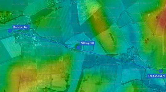 Sourced from topographic-map.com
Here I am sufficiently satisfied this avenue terminated, at the like distance from town as Overton hill was, in the former avenue. Several stones are left dispersedly on banks and meres of lands one great stone belonging to this end of the avenue, lies buried almost under ground in the ploughed land between the barrow west of Longstone Long Barrow, and the last hedge in the town of Beckhampton. am equally satisfied there was no temple or circle of Stones at this end 1st. Because it would be absurd in drawing. The head of the Snake was aptly represented by that double circle on Overton hill; but this place, the of the Snake, admitted no such thing; and I doubt not but it grew narrower and narrower, as we observed of the head of the Snake. Here is not the least report of such a thing among the country people; it would most assuredlv have been well known, because evey stone was demolished within memory, when was there. cannot doubt but many have suffered since; and I have had very disageeable accounts thereof sent to me. I apprehend this end of the avenue drew narrower in imitation of the tail of a snake, and that one stone stood in the middle of the end, by way of close." The, avenue took. another circular swcep of a contrary manner, as it descended from Longstone Cove, bending southward.
..... pars cetera campum
Pone legit, sinuatque immensa terga,"1
as Virgil writes of this creature. And it went over a variety of elevations and depressuyes, as the other of Avnet! E; but that tenninated in a hill, as this in a valley. With great judgment they thus laid out the ground to make the whole more picture like.'
Note 1. Quote from Virgil's Aenid Book 2 lines 203-219 in which Laocoon battles the snakes.
From the above detailed account of the Beckhampton Avenue, we are enabled to judge, in some degree, the line it pursued, and this I am sorry to say, must be our chief authority; for if I except two of the stones which are supposed to have formcd the Longstonc Cove, not one belonging to the avenue remains upright; but by the names of the farms, streets, roads, and barrows, we are enabled to form a tolerably correct judgement respecting the direction of this avenue.
1812. To the Beckhampton avenue there appears formerly to have been an appendage, called Longstone Cove [Map], of which Dr. Stukeley has given the following account. "This Longstone Cove, vulgarly called Longstones, is properly a Cove, as the old Britons called them, composed of three stones, Like the most magnificent one we described in the centre of the Northern temple at Abury. "They are set upon the ark of a circle, regarding each other with an obtuse angle. This is set on the north side of the avenue: one of the stones of that side makes the back of the Cove. This is the only particularity in which this avenue differs from the former. I take it to be chiefly a judicious affectation of variety, and served as to the neighbourhood on ordinary days of devotion. It stands on the midway of the length of the avenue, being the fiftieth stone. This opens to the south-east, as that of the northern temple to the north-east. It is placed upon an eminence, the highest ground which the avenue passes over. These are called Longstone fields from it. Longstone Cove, because standing in the open fields between the Caln road and that to Bath, is more talked of by the people of this country than the larger temple in Abury town.
Mr. Aubrey, in his Monumenta Britannica, thus mentions this fragment of antiquity. "Southward fram Aubury in the ploughed field, doe stand three huge upright stones, perpendicularly, like the three stones at Aubury: they are called "The Devill's Coytes [Map]," In the rude sketch he has givens he delineates them as placed angularly, like those which form the cove of the Northern temple at Abury. Two of the three stones that formed this cove [Map] still remain, and are delineated in one of the engravings annexed to this work, Plate XV, No. 2.
By the following description of this avenue, inserted by the learned Camden in his Britannia, it appears that he had seen Mr. Aubrey's manuscripts, and amongst them the letter before cited from Dr. Toope. He says, "From this place viz. Aubury to West Kennet, is a walk that has been enclosed on each side with large stones; one side, at present, wants a great many, but the other is almost, if not wholly, entire; above which place, on the brow of the hill, is another monument, encompassed with a circular trench, and a double circle of stones, four or five foot high, though most of them are now fallen down: the diameter of the outer circle is forty yards, and of the inner, fifteen. Between West Kennet and this place, is a walk much like that from Aubury thither, at least a quarter of a mile in length." He then recites the circumstance of the discovery of human bones. In the above quotation Mr. Camden has also continued the same statement with Aubrey, in mentioning a trench round the circular temple on Overton hill, and which Dr. Stukeley denies having existed.
Having described the component parts of the Temple at Abury, consisting of the grand circle, comprehending within its area two smaller corcentric circles; "the Kennet avenue terminating with a third circle, supposed to indicate the head of the serpent, as the large circle indicated the body; and also the Beckhampton avenue, which alluded to the tail of the same animal, I shall now proceed to the description of another grand appendage, and perhaps the most mysterious part of the whole work, namely;
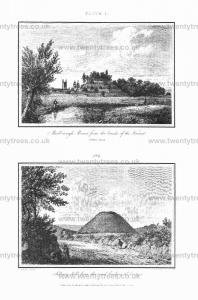
1812. SILBERY HILL [Map] (Plate IV. No. 2.) is an artificial mound of such immense proportions, and so deceitful in its external appearance, that I could never have believed its having stood upon so much ground, had not ascertained the fact by an actual admeasurement.
The learned Stukeley has, in the description of this mound, given his reins to fancy, which has transported him beyond the regions of truth, or even probability for he has stated "that some king as the founder of the temple at Abury, and that Silbury hill was raised for his interment. His opinion, however, is always ingenious, and therefore lay it before my readers.
Silbury, indeed, is a most astonishing collection of earth, artificially raised, worthy of Abury: worthy of the King who was the royal founder of Abury, as may very plausibly affirm. By considering the picture of Abury temple, we may discern, that as This immense body of earth was raised for the sake of the interment of this great prince, whoever he was, so the temple of Abury was made for the sake of this tumulus; and then I have no scruple to affirm, 'tis the mast magnificent mausoleum in the world, without excepting the Egyptian pyramids."
Silbury stands exactly south of Abury, and exactly between the extremities of the two avenues, the head and tail of the Snake. The work of Abury, which is the circle, and the two avenues which represent the snake transmitted through it, are the great hierogrammaton, or sacred prophylactic character of the divine mind, which is protect the deposum of the prince here interred, The Egyptians, for the very same reason, frequently pictured the same hieroglyphic upon the breast of their mummies; and very frequently on the top and summit of Egyptian obelisks, this picture of the serpent and circle is seen, and upon an infinity of their monuments. In the very same manner, this huge snake and circle, made of stones, hangs, as it were brooding over Silbury hill, in order to bring again to a new life the person there buried. For onr Druids taught the expectation of a future life, both soul and bodv, with greatest care, and made it no less than a certainty."
Mar 1723. In the month of March, 1723, Mr. Holford ordered some trees to be planted this hill, in the middle of the area at top, which is sixty cubits (one hundred and three feet nine inches) in diameter. The workmen dug up the body of the great king there buried in the center, very little below the surface; the bones extremely rotten, so that they crumbled them in pieccs with their fingers. The soil was altogether chalk, dug from the side of the hill below, of which the whole banow is made. Six weeks after, I came to rescue a curiosity which they took up there, an iron chain, as they called it, which I bought of John Fowler, one of the workmen: it was the bridle buried along with the monarch, being only a solid body of rust. I immerged it in a limner's drying cloth, and dryed it carefully, keeping it ever since very dry. It is now as fair and entire as when the workmen took it up, There were deer's horns, an iron knife with a bone handle, too, all excessively rotten, taken up along with it."
The fanciful Doctor, for upon this occasion I cannot help bestowing upon him such an epithet, imaoines that the person here buried was the British king Cunedha, and even fixes the time of his death and subsequent interment about the beginning of the month of April; from the circumstance of the country people meeting on the top of Silbury hill every Palm Sunday1 when they make merry with cakes, figs, sugar, and water fetched from the swallow head, or spring of the Kennet.
Note 1. The custom of ascending to the summits of hills on Palm Sunday, is not confined to this hill, for it prevails on another conspicuous eminence in South Wiltshire, namely, Clea hill, near Warminster. H.