Avebury
Avebury is in Prehistoric South England.
Avebury is a landscape of monuments that span a period of two thousand years, 4000BC to 2000BC, comprising a large number of different monuments, and monument types, some of which are unique, some of which are the largest in Britain.
Neolithic Avebury, between 4000BC and 2500BC is represented by numerous Long Barrows and Windmill Hill Causewayed Enclosure [Map], a vast Causewayed Enclosure sited high on a hill in the north-west that overlooks the whole Avebury landscape.
Late Neolithic Early Bronze Age Avebury, broadly between 2500BC and 2200BC. Constructed around the same time as Stonehenge Phase III [Map], only 28 km due south, a days walk, more or less at the same time, probably by the same people, with the same culture? Comprising Avebury Henge, Stones Circles, Avenues and the Sanctuary. The largest henge and stone circle in Britain, the deepest ditch, the highest bank; Avebury henge attracts superlatives. And two Prehistoric Mounds, Silbury Hill [Map] and Marlborough Mound [Map], a distance of 8.4Km apart, possibly inter-visible.
Bronze Age Avebury is represented by the numerous Bronze Age Round Barrows that were constructed in the landscape after the completion of the Henge and Stone Circles.
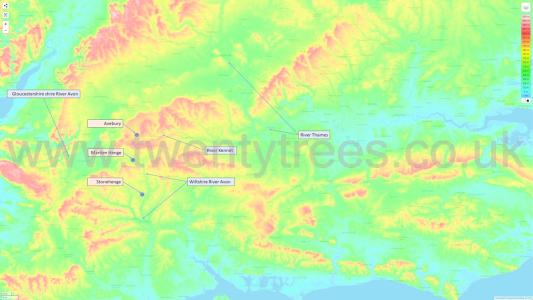
Avebury is located at the western end of a north-east - south-west aligned ridge of hills north-east - south-west through Southern England; the Ridgeway Path follows the hills. The peninsula of land on which Avebury is centred is bounded by the River Thames valley in the north; low-lying ground twenty-five Kms across. To the west another expanse of low-lying ground formed by the Gloucestershire River Avon, and to the south another the low-lying area that forms the headwaters of the Wiltshire River Avon, both around twenty Kms across.
South of Avebury, across the Wiltshire River Avon valley, is Stonehenge, adjacent to the river. Between Avebury and Stonehenge is another Prehistoric Monument: Marden Henge aka Hatfield Earthworks [Map].
Importantly, Avebury is also located at the headwaters of the River Kennet, a tributary of the River Thames, meaning it could be found easily. The River Kennet wasn't necessarily navigable, but it was followable, to Avebury.
Thanks to Topographic Map for the mapping.

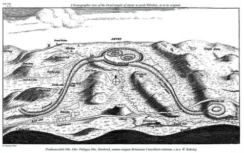
Avebury by William Stukeley. Table VIII. A Scenographic view of the Druid temple of Abvry in north Wiltshire, as in its original. Præhonorabili Dño. Dño. Philippo Dño. Hardwick, summo magnæ Brittanniæ Cancellario tabulam. l.m.d. W. Stukeley. The image shows Windmill Hill Causewayed Enclosure [Map], Horslip Gap [Map], the Long Stones Cove aka Devil's Quoits [Map] aka Devil's Quoits, Beckhampton Avenue, West Kennet Avenue, The Sanctuary [Map], West Kennet Long Barrow [Map]. The hill referred to as Windmill boll is now called Woden Hill.

Colt Hoare 1812. 1812. Plate X. represents the situation of the Temple at Abury, with its two extending avenues; Silbury hill [Map], the principal source of the river Kennet, the British track-way, groups of barrows, and the line of Roman road between Bath and Marlborough. This Plate may be considered as one of the most interesting views which our island can produce. It unites monuments of the earliest British and Roman antiquity, and will, I trust, convey a more correct and explicit idea of Abury and its environs, than any that has heretofore been given. The Plate No. VIII of Stukeley, is both confused and incorrect, because not drawn from actual survey.