Wiltshire Archaeological Magazine 1913 V38 Pages 1-11
Wiltshire Archaeological Magazine 1913 V38 Pages 1-11 is in Wiltshire Archaeological Magazine 1913 V38.
Jun 1913. The Re-Erection of Two Fallen Stones [Long Stones Cove aka Devil's Quoits [Map]], and Discovery of an Interment with Drinking Cup, At Avebury.1 By Mrs. M. E. Cunnington (age 43).
Between 8 and 9 o'clock on the morning of December 2nd, 1911, one of the standing stones at Avebury fell. The stone is one of the two remaining stones of the three which are believed to have once formed a kind of cell, or cove, on the northern side of the Beckhampton, or western avenue, that issued from the great circle of Avebury. The third stone fell and was broken up many years ago. The group was known as "Longstone Cove [Map]," or the "Long- stones," but the two remaining stones are now sometimes spoken of locally as " Adam and Eve." The cove is described by Stukeley2 as consisting of two stones set at an angle to each other outside the avenue, the other stone that Stukeley regarded as the third member of the cove group, being at the same time one of the stones of the avenue. This latter stone is the smaller of the two now remaining, known as "Eve"; the larger one, "Adam," which fell in 1911, being one of the two original outstanding stones of the cove.
Note 1. These notes, so far as they relate to the discovery of the skeleton and drinking cup, were printed in Man, Vol. xii., No. 12, Dec, 1912, pp. 200 — 203, and the Society is indebted to the Council of the Royal Anthropological Institute for the loan of the two blocks which illustrate the paper.
Note 2. The Rev. W. C. Lukis, in a report on Stonehenge and Abury, printed in Proc. Soc. Ant., IX., 131, says (p. 155) of the Longtones Cove, "Stukeley says this cove is 'composed of three stones like that most magnificent one we described in the centre of the northern temple at Abury [Map]. They are set upon the arc of a circle regarding each other, with an obtuse angle,' and are placed on the north side of the avenue, one of the stones of that side making the back of the Cove.... Twining saw two stones only in 1723, therefore Stukeley saw no more; and his knowledge of a third stone must be derived from Aubrey, whose sketch given in his 'Monumenta Britannica' shows how unfaithful his drawings are as to the form and position of the stones. It is altogether an assumption on Stukeley's part that one of the stones of the Cove was one of the supposed avenue.... My own opinion is that these stones are the remains of a large circle — a monument entirely distinct from Avebury."
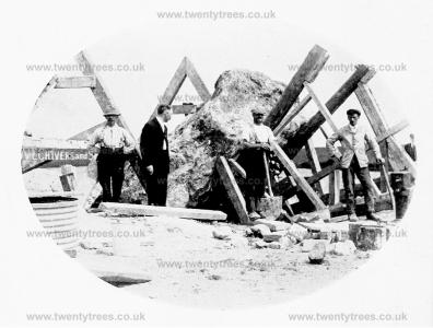
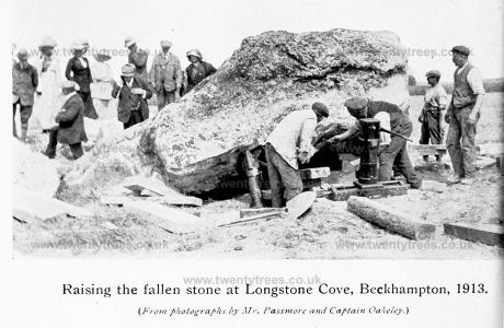
The stones are visible from the road leading from Avebury to Beckhampton, and stand just beyond the end of the private road leading out of that road on the right hand, to Mr. Darling's stables, just as the road dips down into Beckhampton.
At a committee meeting of the Society held in January, 1912, it was decided that an effort should be made to raise funds to re- erect this stone, this being considered advisable largely on the ground that a standing stone is more likely to be respected and safeguarded than one fallen.
Before anything else could be done it was necessary to clear out the hole in which the stone had stood, as it was encumbered with sarsen boulders, which had been originally used as packing to support the great stone, and loose soil which had found its way into the cavity when the stone fell. In case anything of archaeological interest might be found in this digging, Mr. and Mrs. B. H. Cunnington were entrusted with the supervision of the work, which was done with the aid of two labourers on May 24th and 26th, 1912.
When cleared the hole was found to measure 13½ ft. in length, in a direction from East-South-East to West-North-West. The hole widened out somewhat at its East end, its greatest width being 6½ft., while it was 6ft. wide in the middle, and only 4½ft. wide at the West end: it was 3ft. 8in. deep, measured to the surface level, and as the soil at this spot was 15in. deep, the stone had stood only 2ft. 5in. in the solid chalk. The stone had been packed round with about one hundred and fifty sarsen boulders of various sizes, some of them weighing by computation more than a hundred-weight. It is remarkable that some of the flatter boulders had been laid purposely on the floor of the hole prepared to receive the stone. A large piece had split off the bottom of the stone and was found resting against the southern wall of the hole with packing boulders behind it; this piece of stone was itself broken across, and fell into two pieces on being moved. It is difficult to see why the stone should have cracked after its burial in the ground, and it is perhaps possible that it was actually cracked before; if, on the other hand it could have broken in the ground comparatively recently, this may have caused the final collapse of the stone. Most of the packing boulders were found at the easterly and wider end of the hole, the natural irregularity in the shape of the stone requiring a greater amount of packing on that side to give it a firm support.
A discovery that has an important bearing on the date of the erection of the stone, and therefore presumably on the date of the monument of Avebury as a whole, was made in removing the soil in front of the hole preparatory to clearing it out. The discovery was that of the remains of a human skeleton and fragments of a "drinking cup," or " beaker," close to and immediately in front of the hole in which the stone had stood. The section here given shows how very near the burial must have been to the side of the stone when standing; this section, drawn through the centre of the hole, at right angles to its length, cuts as nearly as it was possible to ascertain, through the middle of the burial, showing that it was placed in the centre of this face of the stone. Presuming that the three stones of the cove originally formed a sort of triangular enclosure this face of the stone would have been the inner one.
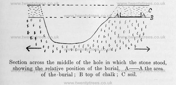
The body had been laid on the level surface of the undisturbed chalk, without the slightest depression or hollow having been made to receive it. The bones were found to have been disturbed and broken in the ground, so that it was not possible to ascertain accurately the original position of the skeleton beyond the fact that it was crouched, and with its head to the East. Nor was it possible to say what had been the original position of the drinking cup. The soil and rubble at this spot is 15in. deep, so that the burial must have been a very shallow one, unless, as is not im- possible, there was originally a slight mound banked up against the stone, that had been levelled by cultivation.
It seems that cultivation is quite enough to account for the broken and disturbed state in which the burial was found; labourers on the spot stated that as it is not possible to plough quite up to the sides of the stones, the ground immediately round them is often dug over by hand, and this would account for dis- turbance of the soil at a greater depth than that of ordinary ploughing.
It is now generally recognised that the "drinking cup" type of pottery belongs to the transition from the Neolithic, or to the earliest Bronze Age, in England, and as there can be little doubt that the burial was made at the foot of the stone after its erection, the importance of the discovery with regard to the date of the monument is considerable. If this is accepted, it shows that this stone, and therefore presumably the whole monument of Avebury, must have been standing at least as early as the beginning of the Bronze Age in England.
The "drinking cup," of which fragments were found with the bones, was a well-made and well-decorated example of its type, namely, the "ovoid cup with recurved rim," and must have stood not less than 8in. in height. The ware is thin, and baked to a bright red both inside and out, showing the grey paste in the middle; the paste is fine and sparingly mixed with sand. The vessel was decorated from lim to base with a series of horizontal lines, alternating with rows of herring-bone pattern, and bands of the plain tooled surface. The horizontal lines, and the lines forming the herring-bone pattern, have the appearance of having been impressed by a notched or serrated tool, as is so often the case on this type of vessel.
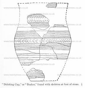
When the stone fell a considerable quantity of loose soil slipped into the cavity among the packing stones, some of which were loosened at the same time. A piece of the rim of the cup, together with a small fragment of Samian ware, and pieces of a modern glass bottle, were found in this loose earth.
A fragment of the rim of another decorated "drinking cup" was found 2ft. deep among undisturbed packing boulders against the wall of the hole on the opposite side to the burial. A phalange of a sheep or goat and a splinter of bone were found under a flat boulder lying undisturbed on the floor of the hole. Several fragments of pottery that may be Romano-British (the small piece of Samian ware found makes this the more likely) were found in the surface soil round the hole.
The bones of the skeleton are unfortunately too incomplete to allow of measurement, but the individual to whom they belonged seems to have been of medium size, and of about middle age. A piece of the collar bone is stained green as if from contact witli some small object of bronze, but no fragment of the metal could be found. The fragments of the drinking cup, together with the remains of the skeleton are placed in the Society's Museum at Devizes.
On behalf of the Committee of the Society, Mr. C. E. Pouting, of Marlborough, and Mr. B. H. Cunnington, of Devizes, undertook the general supervision of the erection of the stones, Messrs. W. E. Chivers & Sons, of Devizes, being the contractors employed. The Society is indebted to the Great Western Railway Company for ttie loan of three jacks (two of 40 tons strength and one of 50 tons) from their works at Swindon, for use in raising the stones.
The plan at first adopted for the Cove stone was that of raising it up by means of the jacks to a certain height, and then affixing wire ropes round the stone to pull it upright by means of two traction engines.1 This plan was found not to be satisfactory, the only result being the breaking of the wire ropes, tested to a strain of 50 tons, without moving the stone at all. Accordingly the stone was eventually raised to the perpendicular by the jacks alone, being supported as the work proceeded, by a shoring of timber and a system of wedges; this method, though slower and consequently more costly, being much more sure and safe.
Note 1. Three photographs appeared in The Sphere of July 27th, 1912, entitled "Adam after the Fall," "Raising Adam with Jacks," and "An unsuccessful attempt to raise the fallen Monster."
The actual work of raising the stone, the weight of which, as computed by measurement, was estimated at 62 tons, was begun on July 9th, and it was finally got upright on August 3rd, 1912, the work having been somewhat delayed by the wet weather.
The stone now rests on a bed of concrete 1ft. thick, the hole having been lowered to take it, and it is also embedded in concrete to the level of the surrounding chalk; it stands 3in. deeper in the ground than it did before its fall.
The society is greatly indebted to Mr. George Brown, of Beckhampton, on whose land the stone stands, for his permission to raise it, and for the kindness and forbearance with which he accepted the inconvenience attendant on the operation. The length of time that the work was about, the trampling of visitors and others through the hedge and the serious interruption to the farming of the land, made no slight call on his patience and good nature. The Society are also grateful to Mr. Brown for his intention not to disturb or cultivate the ground immediately round the stone in the future.
The Kennet Avenue Stone
While the work of raising the big stone at Longstone Cove was in preparation, it was suggested that, while the necessary apparatus was on the ground, it would be a good opportunity to raise the stone in the Kennet avenue that fell cir. 1889 (?), and this course was ultimately decided upon at a committee meeting of the Society in July, 1912. This stone is the third from the Avebury end of the line of seven stones on the east side of the avenue, in the group of eleven stones lying west of the road between Avebury and Kennet and is opposite to the only one of the group which still remained standing. The ground has been under the plough within the last few years, and the cavity made by the fall of the stone had been filled up and levelled off. On re-excavating this it was found that the hole as originally made to receive the stone was not so well defined as in the. case of that at Longstone Cove, where it had been dug into the solid chalk, for the base of the Kennet stone stood on a bed of chalk rubble at a depth of only 16in. below the surface. It was felt that there could be no certainty that this rubble had not been disturbed, and in view of the possibility of an interment having been made under the stone, the digging.was continued down until the solid chalk was reached at a depth of 4ft. Gin. from the surface. The depth of the rubble over the chalk varies considerably even in a small area, but as this seemed a greater depth than is usual, a hole was dug some yards away from thestone to test it there, and the same conditions were found. The spot is at the bottom of the steepish hillside in the valley leading from Avebury to Kennet, a situation where, perhaps, a greater accumulation of debris might be expected than on more open or higher chalk lands.
The stone had fallen inwards, or across the avenue, and toward the upward slope of the hill; the natural irregularity in the shape of the stone had given it a considerable tendency to overbalance in this direction, and it was interesting to find that those who originally put it up must have fully realised this weakness, for they had taken special precautions to overcome it, and all the sarsen boulders used as packing stones were on that side, not one being found against the lower side of the stone. Besides a few flint flakes nothing of interest was found in the digging round this stone.
The thanks of the Society are due to Captain Jenner, of Avebury Manor, the owner of the property on which this part of the Kennet avenue stands, for permission to raise the stone, and to Mr. Parsons, the tenant, for granting access to it.
The computed weight, from measurements, is about 17 tons.
As soon as the jacks were finished with at the Cove stone, they and the necessary timber were moved over to the stone in the Kennet avenue.
The work of raising this stone was begun with the jacks on August 6th, and it was raised to the upright on August 10th, The stone now stands 3in. deeper than it did originally, but otherwise in the same position. It is imbedded in concrete in the same manner as the larger stone.
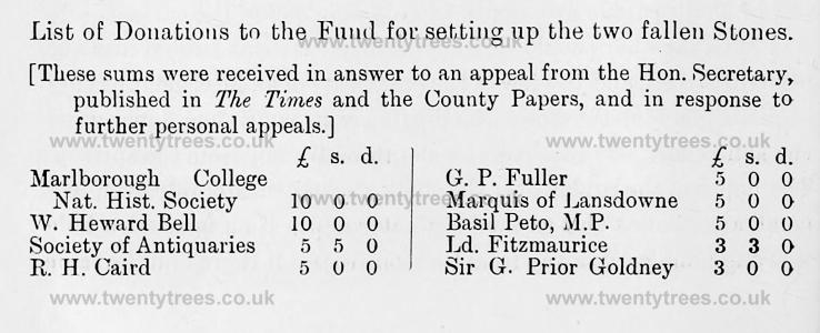
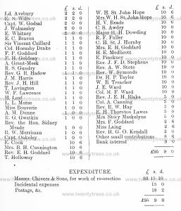
List of Donations to the Fund for setting up the two fallen Stones.
A very curious difficulty arises as to the stone of the Kennet avenue now set up again: one would suppose that there would be no want of evidence as to the fall of a stone so lately as the eighties of the last century, but as a matter of fact it seems impossible to fix the exact year in which it fell, and there was even some doubt as to which of the stones it was that fell. William Long, in his account of Avebury, in Wilts Arch. Mag., iv., 309 — 363, published 1858, gives on page 329 a plan of this group of eleven stones, and says "Upon the ground plan on the opposite page, the distances between the eleven stones, above mentioned, are laid down. The only stone now standing is 8 feet 9 inches high, 9 feet 9 inches wide, and 3 feet thick." This would naturally refer to the stone which has never fallen, No. 2 from the Avebury end of the Western side of the avenue. On page 323, however, he speaks of this group as consisting of "two stones and nine stumps of stones," a curious expression which seems to point to two stones, then standing, as distinguished from nine lying prostrate, though why these latter should be called "stumps" when they are entire stones does not appear. This plan is reproduced by the Rev. A. C. Smith on page 146 of his "Guide to the British and Roman Antiquities of the N. Wiltshire Downs" published in 1884, and he quotes the description of the stones given by Long and only adds "All these stones mentioned by Mr. Long are still in existence," thereby apparently accepting the fact that only one of the eleven stones was standing at the time he wrote.
The ground plan given by both Long and Smith is unfortunately so dubiously drawn that it may be equally claimed as evidence that the stone in question [the third in the line on the East or road side of the avenue as you come from Avebury], was intended to be represented as still standing, or as lying prostrate across the avenue, as it lay before it was recently set up. It is to be noted, too, that it was the only stone of the eleven lying in this position across the avenue.
Both Long and Smith, however, assert in so many words that there was only one stone of this group of eleven standing in 1858 and 1884, when they respectively published their accounts of Avebury, and it is difficult to believe that two writers generally so accurate could have made a mistake of this kind, if two stones were actually then standing. Mr. Smith, especially, had a very extensive and accurate knowledge of Avebury and its surroundings. It is true that he only quotes Long's previous words, but that he should have accepted the statement that one stone only was standing if as a matter of fact, two were still standing, seems very unlikely.
On the other hand there is direct evidence that a second stone was standing until some time in the later eighties of the nineteenth century and that it then fell. Stukeley, in his Abury, p. 42, Tab. xxii., gives a "Prospect of Kennet Avenue from the Druid's Tumulus on Hackpen hill, May 15th, 1724." In this he shows eleven stones, of which four are standing, in the group under " Windmill Ball." Although, however, the total (eleven) is the same, the distribution of the stones (five on the East, and six on the West side of the avenue) does not agree with the distribution of the existing stones, so that this view is of little use as evidence. It is, however, to be noted for what it is worth that the only pair of stones shown as standing are apparently intended for the two actually now standing, viz., the one standing that has not fallen and the one re-erected in 1912. Hoare, in Ancient Wilts, Vol. II., p. 70, published in 1819, gives a plan of "Avebury and Silbury," Plate X. (reproduced in Long's "Avebury," W.A.M., iv., 309), showing the pair of stones, No. 3 on the East and No. 2 on the West side of the avenue (from the Avebury end) as shaded whilst all the other stones of this group are unshaded. This seems clearly to show that both these stones were standing in 1819. Again, Mr. C. E. Ponting, F.S.A., of Marlborough, has a clear recollection of driving past the stones one morning some time in the later " eighties " when the second stone was standing, and noticing when he returned past them at night that it had fallen. He recollects, also, speaking of the matter to Mr. Kemm, of Avebury. He is, however, unable to say with any certainty which of the stones it was that fell, though he thinks it was the one recently raised. William Coleman, a labourer of Avebury, a trustworthy man who has worked for Mr. B. H. Cunnington in excavations, also remembers the fall of the stone, and he says that he noticed that it was leaning badly in the morning as he went to work, and that it fell before he passed it again on his way home, in the evening. He is sure that it was in the month of February, but in what year he cannot say. He believes that the stone now set up again is the stone which then fell. Mr. Butler, of Kennett, and Mr. George Brown, of Avebury, and others, all say that they perfectly well recollect the fall of one of the stones here, and they believe that it was the one now re-erected.
The two stones as they now stand form a pair. It may not be irrelevant to the question to observe that the under side of the stone now re-erected presents a very clean, unweathered, sharp surface, quite distinct from the surface of the upper side which was continuously exposed to the weather.
On the other hand Mrs. Cunnington noted that whilst all the other prostrate stones have deepish hollows worn round them, by the treading of sheep, &c, and have every appearance of having fallen long ago, this stone had little or no hollow round it, and the line of weathering on the butt showing the point up to which it had been buried in the ground was clearly to be seen. But perhaps the strongest piece of evidence in favour of the identity of the stone recently raised with that which fell in the eighties, is the fact that on the ground plan referred to above (W.A.M., iv., 329) Long gives 53ft. as the distance between this stone (x) and the one opposite (y) which has always remained upright. Mr. and Mrs. Cunnington have care- fully tested his measurements of the other stones and find them correct, assuming that he measured from the nearest points of the stones to each other. Bat the distance from the top of the stone x, as it lay prostrate, to the base of y was 44ft., whilst the distance between their bases as both now stand upright is 56ft., a difference of 3ft. only from Long's measurement, and this might be accounted for by the difficulty of knowing within a foot or so where its base had actually stood. In any case the measurements are decidedly in favour of the view that when they were taken both stones were still standing.
It has seemed worth while thus to set out at some length all the evidence at present available, both pro and con. I should be glad to hear of any further light which can be thrown on the matter.
The Rev. W. C. Lukis, whose plans of the Avebury circles are now in the Library of the Society of Antiquaries, did not plan the remains of the Kennet Avenue. He says in Proc. Soc. Ant., IX., 153, "When I had completed the survey of the circles, the weather changed and continued stormy and wet for some time, and I was unable to plan the avenue, which I greatly regret, for I cannot bring myself to think there is any truth in Stukeley's notion that it commenced on Overton Hill, at a monument, of which not a vestige remains." There seems, indeed, a fate against the plans of these stones, for Mr. B. H. Cunnington, who has lately had an opportunity of examining the early editions of the 6-inch Ordnance Map, finds that only six stones on the road side of the avenue at this point are shown, instead of seven, a mistake which has apparently been copied in subsequent editions. E. H. Goddard.
A Buried Stone in Kennet Avenue
A large sarsen, probably one of tbe stones of the Kennet avenue was recently (February, 1913) exposed in a trench cut for the purpose of laying down water pipes. The trench was cut from the top of the hill South of Avebury, sometimes called Windmill Hill, or Windmill Ball,1 across the Kennet-Avebury road, and therefore across the line of the Kennet avenue, to a pumping station in the valley south-east of Avebury vallum.2
Note 1. This hill should not be confused with the Windmill Hill north of Avebury. See Smith's Antiquities of North Wilts, p. 145, d.
Note 2. The pond dug a few years ago on the top of this hill is utilised as a reservoir to which the water is pumped. The barrow marked "d "on Smith's Map (Section XL, G. V.) must have been on the site of, or very near, this pond. No trace of the barrow can now be found.
As one end of the stone projected into the trench, and so was in the way of the pipes, these were laid under it; and in clearing away the rubble from under the stone for this purpose the lower end of a human tibia and some other fragments of bones were found. As so many burials have been found under sarsens in this neighbourhood it seemed worth while to make some examination of this one, especially as from its position it must have been either in, or close to, the Kennet avenue. Therefore, with the permission of Captain Jenner, the owner of the land, and of his tenant, a section was cut at right angles to the trench, exposing the side of the stone furthest from the road. This digging revealed the fact that the stone was, as at first feared, much too large to lift without considerable labour and expense, and the aid of special appliances.
In digging down to the stone, fragments of human bones were found over it, and generally scattered in the chalky rubble filling the hole in which the stone had been buried. The exposed side of the stone was undercut as much as possible, and as far as could be seen, it appeared to be lying on undisturbed chalk, the loose rubble and fragments of bones being only under the shelving side (or edge) of the stone, and as it did not seem likely that an undisturbed burial would be found, it was not thought worth while to carry the work further. It is known that many of the stones of the avenue and of the circles have been buried at various times by the farmers to get them off the land, and it is very probable that this was one of the avenue stones that was got rid of in this way.
To account for the human bones one can only suggest that a burial at the foot of, or near the stone, was disturbed when the hole in which it was buried was dug, and that the bones were thrown in again with the rubble in filling up the hole. It is a curious and suggestive circumstance that a burial should actually have been found at the foot of another stone connected with Avebury, namely, that at Longstone Cove, described above.1
Note 1. A considerable number of burials seem to have been found outside the "Sanctuary" in which the Kennet avenue, ended on Overton Hill. Stukeley's Abury, p. 33. See also Long's Abury. W. A. M., iv., 327.
s the stone was not completely uncovered its full dimensions could not be taken, but one of the exposed sides (that furthest from the road) was 7ft. long, and the other (that in the trench) 4ft. long, It was 2ft. thick and irregular in shape, like the other stones of the avenue, of which Stukeley said they were "of all shapes, sizes, and height that happened." The top of the stone is now 2ft. 9in. below the surface of the ground, and it lies 12ft. from the edge of the road on the right-hand side from Avebury to Kennet. It lies between the single stone standing in a cottage garden just outside the Kennet entrance to Avebury, and the single stone standing close to the left side of the road nearer Kennet; and it is eighty yards on the Avebury side of the last-mentioned stone. If at any time it was desired to uncover this stone again it might be easily found by the fact that the water pipes actually pass under its end nearest Kennet, at a distance of 12ft. from the edge of the road.
None of the human bones were found whole, but only parts of the following: one humerus, two ulnas, one radius, one tibia, one femur, one vertebra, a piece of the sternum, and of a pelvis, and three small bones of the foot. The ulnas are a right and left, and here seems little doubt that all the bones belonged to one skeleton. One of the ulnas was found under the side of the stone, the other in the rubble above it. The bones except for the breakages are sound and in good preservation. Several small pieces of brown and yellow glazed pottery were found in the superficial soil over the stone.
A Dwelling Pit
In cutting the trench near the top of the hill (117 yards from the edge of the pond) the men cut through a small pit. This was cleared out and found to be rather oval in shape, some 3ft. by 4ft. and 3ft. deep. It was full, as these small "dwelling" pits usually are, of black earthy material mixed with grains of charcoal: a sarsen muller, or hammerstone, various fragments of coarse handmade pottery, broken bones of sheep, pig, and ox, some of them burnt, some rough flint flakes, including two "scrapers," and burnt flints were found in it.
Wessex from the Air Plate 36. Literary References
John Aubrey, Mon. Brit. (Bodleian Library, Oxford); plan of Avebury made 1663; reproduced in facsimile in W.A.M., vol. vii.
Willaim Stukeley, Abury, a temple of the British Druids, 1743.
William Long, ‘Abury Wiltshire Archaeological Magazine, vol. iv (January 1858), pp. 309-63. (This is by far thebest existing account of Avebury.)
Facsimiles of Aubrey’s plans of Avebury, and corrigenda of preceding paper; W.A.M. vii (December 1861) ,pp, 224—6.
The Rev, A, C. Smith, 'Excavations at Avebury W,A.M, x (January 1867), pp. 209-16. (An account of excavations made there by Mr. Smith, associated with Messrs. W. G. Lukis, W. Cunnington, and King, 29th September to 5th October 1865. Excavations were made in the Northern Inner Circle, near and also within the Cove itself, in the mound or embankment to the south-east, in the Southern Circle, and through the Great Outer Bank.)
William Long, 'Abury Notes’, W.A.M. xvii (March 1878), pp. 327-35. (Valuable notes on lost, buried, or destroyed stones in the circles and avenues, especially the Kennet Avenue.)
The Rev. Bryan King, Vicar of Avebury, ‘Avebury— The Beckhampton Avenue’, W.A.M. xviii (November 1879), pp. 377-83. (A vigorous defence of the Beckhampton Avenue, supported by evidence.)
‘A buried stone in the Kennet Avenue’, W.A.M. xxxviii (June 1913), pp. 12—14.
H. St. George Gray, Reports on Excavations at Avebury; published in the Reports of the British Association for the years 1908 (401-11), 1909 (271-84), 1911 (141-52), 1915 (174-89), 1922 (326-33).