Europe, British Isles, South-West England, Wiltshire, Avebury Henge and Stones, Avebury Henge
Avebury Henge is in Avebury Henge and Stones [Map], Avebury Late Neolithic Early Bronze Age, South England Henges.
Avebury Henge is sub-circular ie not a circle. Neither is it symmetrical. Difficult to give the shape a name since it is so irregular.
Carbon Date. 2640BC. Late Neolithic Carbon Dates
Report: Bone, AML 831778, id as animal, from old land surface under bank of henge (NW quadrant, cutting II) at Avebury, Wiltshire, England. Subm M Pitts 1985. [Ed: NGR not given, estimated only.]
ID: 8807, C14 ID: HAR-10325 Date BP: 4640 +/- 70, Start Date BP: 4570, End BP: 4710
OS Letter: SU, OS East: 9, OS North: 69
Archaeologist Name: M Pitts 1982
Reference Name: Radiocarbon, 34, 1992, 61-2; Proc Prehist Soc, 58, 1992, 203-12; Archaeologia, 84, 1935, 99-162; Smith I, 'Windmill Hill and Avebury' (Oxford, 1965)
Council for British Archaeology (2012) Archaeological Site Index to Radiocarbon Dates from Great Britain and Ireland [data-set]. York: Archaeology Data Service [distributor] https://doi.org/10.5284/1017767
Carbon Date. 2160BC. Early Bronze Age Carbon Dates
Report: Antler, AML 831779, id as red deer, from above bank of henge (NW quadrant) above possible revetment trench at Avebury, Wiltshire, England. Subm M Pitts 1987. Comment (subm): dates possible extension to bank, compatible with HAR-10502. [Ed: NGR not given, estimated only.]
ID: 8808, C14 ID: HAR-10326 Date BP: 4160 +/- 90, Start Date BP: 4070, End BP: 4250
OS Letter: SU, OS East: 9, OS North: 69
Archaeologist Name: A Keiller (age 47) 1937
Reference Name: Radiocarbon, 34, 1992, 61-2; Proc Prehist Soc, 58, 1992, 203-12; Archaeologia, 84, 1935, 99-162; Smith I, 'Windmill Hill and Avebury' (Oxford, 1965)
Council for British Archaeology (2012) Archaeological Site Index to Radiocarbon Dates from Great Britain and Ireland [data-set]. York: Archaeology Data Service [distributor] https://doi.org/10.5284/1017767
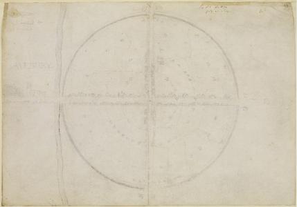 Jul 1663. John Aubrey (age 37). Ground Plan of Avebury.
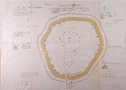 Before 1697. John Aubrey (age 70). Ground Plan of Avebury.
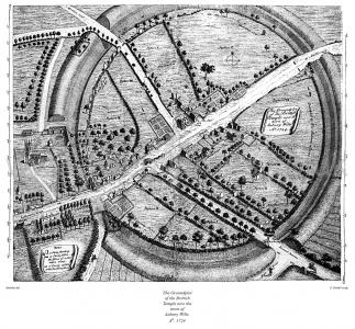
Colt Hoare 1812. Plate XII represents a ground plan of the Grand Circle at Abury, taken by Dr. Stukeley (age 36) in the year 1724.; but from the inaccuracy of its outline, and the position of the two concentric temples, I doubt whether this plan was taken from actual survey1. It is, however, particularly interesting to the present age, as recording the state the circle at, a distant period, when it appears to have had eighteen stones standing, and twenty-seven fallen of the outward circumvallation; two standing, and nine fallen of the outward circle of the Northern Temple; one standing, and five fallen of the Inner Circle, and two out of three large upright stones that formed the COVE [Map]. Of the adjoining Southern Temple, four stones of the outward circle were standing in their original situation, and seven were fallen down; but one stone alone remained standing of the interior circle.
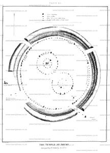
Avebury by William Stukeley. 1724. Table I. Frontspiece. The Groundplot of the Brittish Temple now the town of Aubury Wilts. Ao. 1724. [Note. This drawing shows the location of a number of stones that were destroyed and the year in which they were destroyed. Curiously it shows the outer circle and inner north circle as being composed on two rings of stones rather than the one ring we presume today. Also interesting is that there is a note on the east entrance staying 'road to Marlborough' - this being the route to the Ridgeway.]
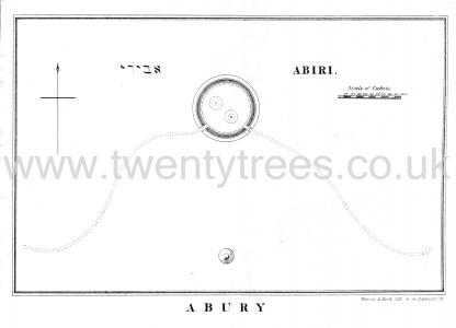
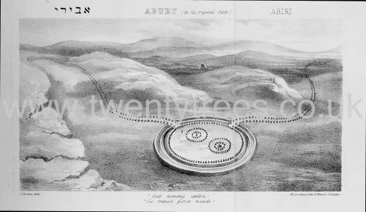
Druidical Temples in the County of Wilts Chapter V. Chapter V. On The Serpent At Abury.
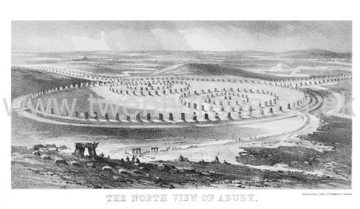
Druidical Temples in the County of Wilts Chapter VI. Chapter VI. The Temples At Abury.
Antiquity 1936 Volume 10 Issue 40 Pages 417-427. The Recent Excavations at Avebury by Alexander Keiller (age 45) and Stuart Piggott (age 24).
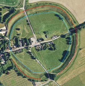
Silbury Hill [Map] is visible from some, but not all, of the Avebury Henge - the red line on the Schematic.
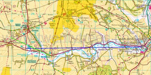 The light orange is land above 150m. The dark orange is land above 200m.
Europe, British Isles, South-West England, Wiltshire, Avebury Henge and Stones, Avebury Henge Bank ![]()
Carbon Date. 2640BC. Late Neolithic Carbon Dates
Report: animal bone; from the old land surface under the henge bank; north-west sector, trench 2, LZ. Excavated in 1982 (Evans et al 1985).
ID: 15117, C14 ID: HAR 10325 Date BP: 4640 +/- 70, Start Date BP: 4710, End BP: 4570
Abstract: Avebury; 1984-85
Reference Name: Bayliss, A, Hedges, R, Otlet, R, Switsur, R, and Walker, J 2012 'Radiocarbon dates: from samples funded by English Heritage between 1981 and 1988', Swindon: English Heritage
Council for British Archaeology (2012) Archaeological Site Index to Radiocarbon Dates from Great Britain and Ireland [data-set]. York: Archaeology Data Service [distributor] https://doi.org/10.5284/1017767
Carbon Date. 2380BC. Early Bronze Age Carbon Dates
Report: Charcoal, AML 822624, from old land surface under henge bank (SE quadrant Cutting X) at Avebury, Wiltshire, England. Subm M Pitts 1987. [Ed: NGR not given, estimated only.]
ID: 8805, C14 ID: HAR-10063 Date BP: 4380 +/- 80, Start Date BP: 4300, End BP: 4460
OS Letter: SU, OS East: 9, OS North: 69
Archaeologist Name: H St George Gray 1914
Reference Name: Radiocarbon, 34, 1992, 61-2; Proc Prehist Soc, 58, 1992, 203-12; Archaeologia, 84, 1935, 99-162; Smith I, 'Windmill Hill and Avebury' (Oxford, 1965)
Council for British Archaeology (2012) Archaeological Site Index to Radiocarbon Dates from Great Britain and Ireland [data-set]. York: Archaeology Data Service [distributor] https://doi.org/10.5284/1017767
Carbon Date. 2380BC. Early Bronze Age Carbon Dates
Report: charcoal; from the old land surface under the henge bank; south-east sector, cutting X. Excavated by Gray in 1914 (Gray 1935).
ID: 15115, C14 ID: HAR 10063 Date BP: 4380 +/- 80, Start Date BP: 4460, End BP: 4300
Abstract: Avebury; 1984-85
Reference Name: Bayliss, A, Hedges, R, Otlet, R, Switsur, R, and Walker, J 2012 'Radiocarbon dates: from samples funded by English Heritage between 1981 and 1988', Swindon: English Heritage
Council for British Archaeology (2012) Archaeological Site Index to Radiocarbon Dates from Great Britain and Ireland [data-set]. York: Archaeology Data Service [distributor] https://doi.org/10.5284/1017767
Carbon Date. 2190BC. Early Bronze Age Carbon Dates
Report: Charcoal, AML 831777, AV2, id as Crataegus sp, Aesculus sp and Corylus, from old land surface under henge bank at Avebury, Wiltshire, England. Subm M Pitts 1985. [Ed: NGR not given, estimated only.]
ID: 8812, C14 ID: HAR-10500 Date BP: 4190 +/- 90, Start Date BP: 4100, End BP: 4280
OS Letter: SU, OS East: 9, OS North: 69
Archaeologist Name: A Keiller (age 48) 1938
Reference Name: Radiocarbon, 34, 1992, 61-2; Proc Prehist Soc, 58, 1992, 203-12; Archaeologia, 84, 1935, 99-162; Smith I, 'Windmill Hill and Avebury' (Oxford, 1965)
Council for British Archaeology (2012) Archaeological Site Index to Radiocarbon Dates from Great Britain and Ireland [data-set]. York: Archaeology Data Service [distributor] https://doi.org/10.5284/1017767
Carbon Date. 2190BC. Early Bronze Age Carbon Dates
Report: charcoal; from the old land surface under the henge bank; south-west sector behind stone 14 (excavated by Keiller in 1938 (Smith 1965)).
ID: 15120, C14 ID: HAR 10500 Date BP: 4190 +/- 90, Start Date BP: 4280, End BP: 4100
Abstract: Avebury; 1985-86
Reference Name: Bayliss, A, Hedges, R, Otlet, R, Switsur, R, and Walker, J 2012 'Radiocarbon dates: from samples funded by English Heritage between 1981 and 1988', Swindon: English Heritage
Council for British Archaeology (2012) Archaeological Site Index to Radiocarbon Dates from Great Britain and Ireland [data-set]. York: Archaeology Data Service [distributor] https://doi.org/10.5284/1017767
Carbon Date. 2160BC. Early Bronze Age Carbon Dates
Report: antler; from the bank make-up of the henge, above a supposed revetment trench. Excavated by Keiller in 1937 (Smith 1965).
ID: 15118, C14 ID: HAR 10326 Date BP: 4160 +/- 90, Start Date BP: 4250, End BP: 4070
Abstract: Avebury; 1984-85
Reference Name: Bayliss, A, Hedges, R, Otlet, R, Switsur, R, and Walker, J 2012 'Radiocarbon dates: from samples funded by English Heritage between 1981 and 1988', Swindon: English Heritage
Council for British Archaeology (2012) Archaeological Site Index to Radiocarbon Dates from Great Britain and Ireland [data-set]. York: Archaeology Data Service [distributor] https://doi.org/10.5284/1017767
Carbon Date. 800. Early Medieval
Report: grain; from a pit (1.1m deep, 1.51m x 1.0m across the oval top) containing carbonised grain, probably originally in a basket. This pit was 3m outside the foot of the bank of the Avebury henge monument, on the south-west side, and cut through the first layer of soil rainwashed off the bank, but was covered by a second layer of rainwash, and then by thick topsoil. The estimated date of the bank is between 2500 and 2000 BC.
ID: 15126, C14 ID: HAR 1696 Date BP: 1200 +/- 80, Start Date BP: 1280, End BP: 1120
Abstract: Avebury: School Site; 1976-77
Reference Name: Jordan, D, Haddon-Reece, D, Bayliss, A 1994 'Radiocarbon dates: from samples funded by English Heritage and dated before 1981', London: English Heritage
Council for British Archaeology (2012) Archaeological Site Index to Radiocarbon Dates from Great Britain and Ireland [data-set]. York: Archaeology Data Service [distributor] https://doi.org/10.5284/1017767
Keiller Collection Photos. Apr 1914. A photo of Avebury’s bank and ditch. The figures on the bank are thought to be Harold Gray's (age 42) wife Florence Harriet Young (age 38) and their son Lionel St George Gray (age 13).
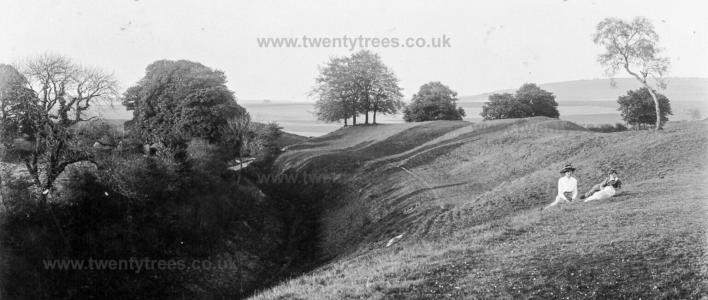
Europe, British Isles, South-West England, Wiltshire, Avebury Henge and Stones, Avebury Henge Ditch
Carbon Date. 2300BC. Early Bronze Age Carbon Dates
Report: antler; from the primary fill of the henge ditch, west of the south causeway; gray cutting I. Excavated by Gray in 1909, find no. 136, (Gray 1935).
ID: 15122, C14 ID: HAR 10502 Date BP: 4300 +/- 90, Start Date BP: 4390, End BP: 4210
Abstract: Avebury; 1985-86
Reference Name: Bayliss, A, Hedges, R, Otlet, R, Switsur, R, and Walker, J 2012 'Radiocarbon dates: from samples funded by English Heritage between 1981 and 1988', Swindon: English Heritage
Council for British Archaeology (2012) Archaeological Site Index to Radiocarbon Dates from Great Britain and Ireland [data-set]. York: Archaeology Data Service [distributor] https://doi.org/10.5284/1017767
Carbon Date. 2300BC. Early Bronze Age Carbon Dates
Report: Antler pick, AML 831780, from primary fill of henge ditch W of S entrance (Cutting I) at Avebury, Wiltshire, England. Subm M Pitts 1985. Comment (subm): at face value, slightly earlier than Durrington Walls and Mount Pleasant. [Ed: NGR not given, estimated only.]
ID: 8810, C14 ID: HAR-10502 Date BP: 4300 +/- 90, Start Date BP: 4210, End BP: 4390
OS Letter: SU, OS East: 9, OS North: 69
Archaeologist Name: H St George Gray 1909
Reference Name: Radiocarbon, 34, 1992, 61-2; Proc Prehist Soc, 58, 1992, 203-12; Archaeologia, 84, 1935, 99-162; Smith I, 'Windmill Hill and Avebury' (Oxford, 1965)
Council for British Archaeology (2012) Archaeological Site Index to Radiocarbon Dates from Great Britain and Ireland [data-set]. York: Archaeology Data Service [distributor] https://doi.org/10.5284/1017767
Carbon Date. 1690BC. Middle Bronze Age Carbon Dates
Report: Charcoal, AML 822623, from deposit of burnt material beneath 'dwarf' burial in secondary fill of ditch (c 2 below modern surface) in terminal of ditch E of S entrance (Cutting IX) at Avebury, Wiltshire, England. Subm M Pitts 1987. [Ed: NGR not given, estimated only.]
ID: 8806, C14 ID: HAR-10064 Date BP: 3690 +/- 80, Start Date BP: 3610, End BP: 3770
OS Letter: SU, OS East: 9, OS North: 69
Archaeologist Name: H St George Gray 1914
Reference Name: Radiocarbon, 34, 1992, 61-2; Proc Prehist Soc, 58, 1992, 203-12; Archaeologia, 84, 1935, 99-162; Smith I, 'Windmill Hill and Avebury' (Oxford, 1965)
Council for British Archaeology (2012) Archaeological Site Index to Radiocarbon Dates from Great Britain and Ireland [data-set]. York: Archaeology Data Service [distributor] https://doi.org/10.5284/1017767
Carbon Date. 1690BC. Middle Bronze Age Carbon Dates
Report: charcoal; from a deposit of burnt material beneath a 'dwarf' burial in the secondary fill of the henge ditch, 1.8 - 2.1m below the modern surface of the ditch; from the south-east quadrant east of the south entrance. Excavated by Gray in 1914, cutting IX, find no. 247h (Gray 1935).
ID: 15116, C14 ID: HAR 10064 Date BP: 3690 +/- 80, Start Date BP: 3770, End BP: 3610
Abstract: Avebury; 1984-85
Reference Name: Bayliss, A, Hedges, R, Otlet, R, Switsur, R, and Walker, J 2012 'Radiocarbon dates: from samples funded by English Heritage between 1981 and 1988', Swindon: English Heritage
Council for British Archaeology (2012) Archaeological Site Index to Radiocarbon Dates from Great Britain and Ireland [data-set]. York: Archaeology Data Service [distributor] https://doi.org/10.5284/1017767
Europe, British Isles, South-West England, Wiltshire, Avebury Henge and Stones, Avebury Henge Entrances ![]()
Europe, British Isles, South-West England, Wiltshire, Avebury Henge and Stones, Avebury Henge Entrances, Avebury Henge East Entrance [Map]
The Avebury Henge East Entrance [Map] is marked by a stone in the Outer Circle that is considerably larger than other extant stones suggesting the entrance was part of the original design. The entrance opens the track to the Ridgeway Path two kilometres away on Overton Down [Map] on ground ninety metres higher than that on which Avebury is located.
From Avebury Henge East Entrance [Map] a path leads east to the Ridgeway Path [Map]; a distance of 2.4 Km.
Europe, British Isles, South-West England, Wiltshire, Avebury Henge and Stones, Avebury Henge Entrances, Avebury Henge North Entrance [Map]
Avebury Henge North Entrance [Map] is marked by a large stone known as the Swindon Stone, which suggests the entrance was part of the original design. The entrance is now used by the A361 road to Swindon which exits at the Avebury Henge South Entrance [Map].
Antiquity 1939 Volume 13 Pages 223-233. A discovery of considerable importance was made when, on examining material which had been tipped into the ditch to form the course of a medieval track-way, a causeway of solid chalk [Map] was found to exist. An original entrance through the bank and over the ditch from the north was therefore proved to have existed. The breadth of this causeway could not be ascertained owing to its northeastern edge being at present under the main road to Swindon.
Europe, British Isles, South-West England, Wiltshire, Avebury Henge and Stones, Avebury Henge Entrances, Avebury Henge South Entrance [Map]
The Avebury Henge South Entrance [Map] appears to have been original since it terminates the West Kennet Avenue. Further there are two exceptionally large stones at the entrance that appear to continue the West Kennet Avenue through the entrance to the Avebury South Circle.
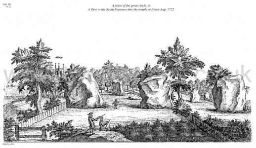
Avebury by William Stukeley. Table XII. A piece of the great circle, or A View at the South Entrance [Map] into the temple at Abury Aug. 1722.
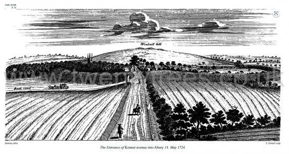
Avebury by William Stukeley. Table XVIII. The Entrance of Kennet avenue into Abury [Map] 14 May 1724.
Europe, British Isles, South-West England, Wiltshire, Avebury Henge and Stones, Avebury Henge Entrances, Avebury Henge West Entrance [Map]
Avebury Henge West Entrance [Map] is somewhat vague with a considerable part of the bank having been removed and the ditch infilled. If it did exist it would have been the start of the Beckhampton Avenue.
Europe, British Isles, South-West England, Wiltshire, Avebury Henge and Stones, Avebury Henge Removed Bank ![]()
Avebury by William Stukeley. When the Lord Stowell [Note. Ralph Stawell 1st Baron Stawell], who owned the manor of Abury, levelled the vallum on that side of the town next the church, where the barn now stands, the workmen came to the original surface of the ground, which was easily discernible by a black stratum of mold upon the chalk. Here they found large quantities of bucks' horns, bones, oyster-shells, and wood coals. The old man who was employed in the work says, there was the quantity of a cart-load of the horns, that they were very rotten, that there were very many burnt bones among them.
Europe, British Isles, South-West England, Wiltshire, Avebury Henge and Stones, Avebury Henge, Centre of the Henge [Map]![]()
The Centre of the Henge [Map] is somewhat difficult to locate given the Henge is sub-circular. Given the alignments of the entrances, and the alignment to the Midwinter Sunset and Midsummer Sunrise, it would appear the centre of the monument is on the corner of the pub car-park where the road from Swindon makes a right turn?
The road through the Henge, inexplicably, makes a curious change in direction twice around the centre? There is no obvious reason why it does this rather than form a straight line between the North and South entrances.