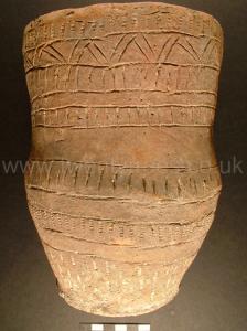
Europe, British Isles, South-West England, Wiltshire, Stonehenge Landscape, Stonehenge Barrows, Winterborne Stoke Barrows, Winterbourne Stoke Barrows
Winterbourne Stoke Barrows is in Winterborne Stoke Barrows.
Europe, British Isles, South-West England, Wiltshire, Stonehenge Landscape, Stonehenge Barrows, Winterborne Stoke Barrows, Winterbourne Stoke Barrows, Winterbourne Stoke Barrow 1 G1 [Map]
Colt Hoare 1812. No. 1 [Map]. The first of these is a long barrow, situated between the angle of the cross roads, which we did not open, being so well satisfied about the history of this species of tumuli.
Wiltshire Archaeological Magazine 1902 V32 Page 175. The attention of the Committee has been called during the year, amongst other things, to the proposed cleaning and scraping of the Market Cross at Salisbury, and to the injury being done to the fine long barrow at Winterbourne Stoke cross roads [Map]. The Salisbury Town Council yielded to the representations made by our Society and by the Society of Antiquaries, and has decided not to scrape the stonework of the Market Cross. The Secretary lost no time in interceding for the preservation of one of the finest of the long barrows, and it is hoped that further damage to it is averted.
Wiltshire Archaeological Magazine 1913 V38 Pages 379-414. Winterbourne Stoke1. 1. [Winterbourne Stoke Barrow 1 G1 [Map]] At the cross roads on the Winterbourne Stoke — Wilsford parish boundary. No. 1 of Hoare's Winterbourne Stoke Group. Length 240ft. (Thurnam); N.E. and S.W. Opened by Thurnam in 1863. Under the highest part of the mound he found, either on or below the floor "the remains of the original interment, viz., the skeleton of a man laid on its right side, with the knees drawn up in a closely contracted posture, and the head to the S.W. Close to the right arm lay a natural bludgeon-shaped flint, about 8in. long, well adapted for being grasped in the hand; from one end numerous flakes have been knocked off." A secondary burial of six crouched skeletons was found, about 2ft. from the surface of the mound, and with them an empty vase of very coarse British pottery and an oval flint knife.
This barrow is down to grass and in a good state of preservation; but it has been disfigured on the N.W. side, where a few years ago they began to utilise the mound as a quarry for chalk.2 O.M. 54 SW.; A.W. I. 121; Arch. xlii. 180, 194, 197; Mem. Anthrop Soc. i. 140; MS. Cat. Nos. 159, 162 (in reference to the skull of the primary and three skulls of the secondary burial).3
Note 1. This is the barrow referred to by Thurnam as "Winterbourne Stoke."
Note 2. About 1900, see W.A.M. xxxii. 175.
Note 3. Thurnam speaks of one of these skulls as "one of the most brachycephalic British skulls yet described."
Europe, British Isles, South-West England, Wiltshire, Stonehenge Landscape, Stonehenge Barrows, Winterborne Stoke Barrows, Winterbourne Stoke Barrows, Winterbourne Stoke Barrow 2 G2 [Map]
Colt Hoare 1812. No. 2 [Map] is a fine barrow, 93 feet in diameter, and 8 in elevation. The interment of burned bones which it contained, was piled up in a litde heap upon the floor of the barrow, and amongst them was a small urn.
Europe, British Isles, South-West England, Wiltshire, Stonehenge Landscape, Stonehenge Barrows, Winterborne Stoke Barrows, Winterbourne Stoke Barrows, Winterbourne Stoke Barrow 3 G21b [Map]
Colt Hoare 1812. No. 3 [Map] had been partly intersected in forming the turnpike road. Near the Cap of this barrow was an urn rudely formed, with an ornament on the rim in relief, like the shape of an horse-shoe, and enclosing a deposit of burned bones; we missed the primary interment.
Europe, British Isles, South-West England, Wiltshire, Stonehenge Landscape, Stonehenge Barrows, Winterborne Stoke Barrows, Winterbourne Stoke Barrows, Winterbourne Stoke Barrow 4 G21a [Map]
Europe, British Isles, South-West England, Wiltshire, Stonehenge Landscape, Stonehenge Barrows, Winterborne Stoke Barrows, Winterbourne Stoke Barrows, Winterbourne Stoke Barrow 5 G19 [Map]
Europe, British Isles, South-West England, Wiltshire, Stonehenge Landscape, Stonehenge Barrows, Winterborne Stoke Barrows, Winterbourne Stoke Barrows, Winterbourne Stoke Barrow 6 G21 [Map]
Europe, British Isles, South-West England, Wiltshire, Stonehenge Landscape, Stonehenge Barrows, Winterborne Stoke Barrows, Winterbourne Stoke Barrows, Winterbourne Stoke Barrow 7 G20 [Map]
Colt Hoare 1812. No. 7 [Map]. At the depth of four feet from the Hoor of this barrow, was found the skeleton of a child, with a bason-like urn; and in a cist cut in the native chalk was the primary deposit of an adult skeleton, lying from north to south, with a drinking cup at his feet.
Europe, British Isles, South-West England, Wiltshire, Stonehenge Landscape, Stonehenge Barrows, Winterborne Stoke Barrows, Winterbourne Stoke Barrows, Winterbourne Stoke Barrow 8 G18 [Map]
Colt Hoare 1812. No. 8 [Map]. This is one of that species we have styled Druid barrows of the second In the centre it had an oval cist, four and a half feet long, and two feet class, wide, with an even floor of chalk: and in the middle of it was a heap of burned bones, but no ashes, At the distance of a foot was a fine drinking cup, richly ornamented, but unfortunately broken on removing.
Europe, British Isles, South-West England, Wiltshire, Stonehenge Landscape, Stonehenge Barrows, Winterborne Stoke Barrows, Winterbourne Stoke Barrows, Winterbourne Stoke Barrow 9 G17 [Map]
Colt Hoare 1812. No. 9 [Map] contained a simple interment of burned bones.
Europe, British Isles, South-West England, Wiltshire, Stonehenge Landscape, Stonehenge Barrows, Winterborne Stoke Barrows, Winterbourne Stoke Barrows, Winterbourne Stoke Barrow 10 G16 [Map]
Colt Hoare 1812. It appears doubtful if No. 10 [Map] was sepulchral, as on making a large section in it, we could perceive no signs of interment.
Europe, British Isles, South-West England, Wiltshire, Stonehenge Landscape, Stonehenge Barrows, Winterborne Stoke Barrows, Winterbourne Stoke Barrows, Winterbourne Stoke Barrow 11 G16a [Map]
Colt Hoare 1812. In No. 11 [Map] we found a deposit of burned bones, a small cup, of thick British pottery richly ornamented, but unfortunately broken, and a bone pin of a different form from any we have yet found, being bent in a semicircular form, and perforated at the head.
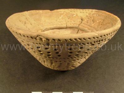
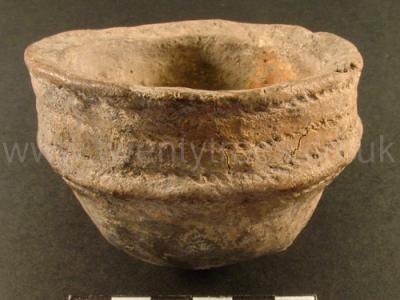
Wiltshire Museum. DZSWS:STHEAD.79a. 1 Aldbourne incense cup with vertical lines of dots between two pairs parallel lines of impressed cord on the outside (the lower half containing diagonal hatchings of cord and two perforations) and a wide flared rim decorated with zigzags between two pairs of parallel impressed cord lines on the inside found with a primary (?) cremation in Bowl barrow Winterbourne Stoke G16a [Map], excavated by William Cunnington.
Europe, British Isles, South-West England, Wiltshire, Stonehenge Landscape, Stonehenge Barrows, Winterborne Stoke Barrows, Winterbourne Stoke Barrows, Winterbourne Stoke Barrow 12 G3 [Map]
Colt Hoare 1812. No. 12 [Map], a very low barrow, produced only a simple interment by cremation.
Europe, British Isles, South-West England, Wiltshire, Stonehenge Landscape, Stonehenge Barrows, Winterborne Stoke Barrows, Winterbourne Stoke Barrows, Winterbourne Stoke Barrow 13 G1a [Map]
Colt Hoare 1812. In No. 13 [Map] nothing was found; and No. 14 [Map] is a pond barrow.
Europe, British Isles, South-West England, Wiltshire, Stonehenge Landscape, Stonehenge Barrows, Winterborne Stoke Barrows, Winterbourne Stoke Barrows, Winterbourne Stoke Barrow 14 G3a [Map]
Colt Hoare 1812. In No. 13 [Map] nothing was found; and No. 14 [Map] is a pond barrow.
Europe, British Isles, South-West England, Wiltshire, Stonehenge Landscape, Stonehenge Barrows, Winterborne Stoke Barrows, Winterbourne Stoke Barrows, Winterbourne Stoke Barrow 16 G5 King Barrow [Map]
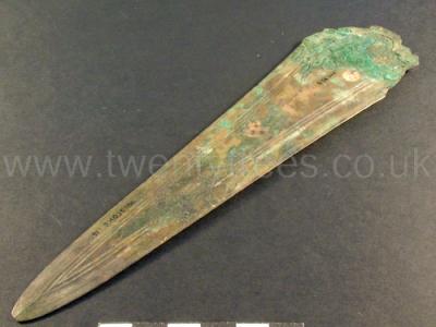
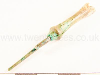
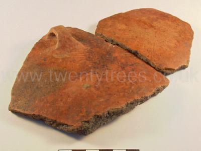
Colt Hoare 1812. No. 16 [Map]. This, and the preceding barrow, both for superiority of size, and elegance of form, may be justly considered as the two finest tumuli in this group: they stand so contiguous to each other, that their circumvallation somewhat interfere. The first mentioned, is 89 feet in base diameter, and 14 feet in elevation: the one, now the object of our inquiry, measures in its base diameter 112 feet, and about 15 feet in elevation. On making our section, we were surprised to meet with a large and heavy piece of fossil wood, of a calcareous nature, resembling a bunch of twigs. I cannot learn that there is any substance of the kind in this neighbourhood, and I am sure the earth of which the barrow is composed, could never have generated it. At the depth of nearly 15 feet, and immediately under the spot where the fossil wood was found, we came to a shallow oblong cist, in which a skeleton had been deposited within the rude trunk of an elm-tree1, with its head lying to the north-east, On the left side of the head, a beautiful urn had been deposited, but crushed to pieces by the heavy pressure of earth upon it. We were however fortunate in collecting sufficient fragments to enable Mr. Crocker to make out an exact drawing of its and outline. (Tumuli Plate XV.) This sepulchral urn is different both in shape and colour to any we have ever found in the British sepulchres. It resembles in tint the fine red Samian pottery, and appears to have been turned in a lathe; the form of the neck is neat, and the five handles are like those we see on the Roman vessels; yet with all these appearances, we have one criterion to judge by, which, I think, will prove it ta be of British manufacture, viz. that it is not more than half baked, and the fractures discover a black and sooty appearance within, not having been burned in a kiln, like the pottery of the Romans. Near the breast of the skeleton, lay the brass dagger No. 2. which had been guarded by a case of wood, part of which appeared to have been highly ornamented, as we found a bit of wood near it that had indentations which certainly had been gilt. The handle seems to have been made of box wood, and rounded somewhat like that of a large knife, Near it lay a brass pin with an ivory handle, No. g. On the same side, but near the thigh, was a fine spear-head of brass, No, 4, very perfect, and most elegantly moulded, (for I have no doubt of these articles having been cast in moulds), and another article or ivory. The rich contents of this tumulus has induced us to crown it with royal honours, and to give it the title of KING BARROW. I have often been asked, if the largest barrows were not found, on opening, to be the most productive in their contents? The question is very natural, and I have rather wished to second that supposition; but as yet I have not a basis for that hypothesis. In the present instance, indeed, there is some ground for the above remark.
Note 1. The knots and bark adhering to the tree, we were able to ascertain with certainty its distinct species some naturalists, however, suppose, that the elm was introduced from the Continent into England. at a comparatively modern period.
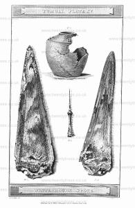
Wiltshire Museum. DZSWS:STHEAD.23. 1 bronze dagger with 3 grooves either side and no ridge, found with a primary inhumation (in an elm trunk coffin) in bell barrow Winterbourne Stoke G5 [Map], excavated by William Cunnington.
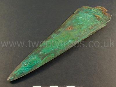
Wiltshire Museum. DZSWS:STHEAD.24. 1 bronze dagger with 3 grooves either side and no ridge, found with a primary inhumation (in an elm trunk coffin) in bell barrow Winterbourne Stoke G5 [Map], excavated by William Cunnington.
Wiltshire Museum. DZSWS:STHEAD.25. 1 bronze awl with bone handle, found with a primary inhumation (in an elm trunk coffin) in bell barrow Winterbourne Stoke G5 [Map], excavated by William Cunnington.
Wiltshire Museum. DZSWS:STHEAD.73. 2 red burnished potsherds from a Breton Urn, one with a loop for suspension (there would have been five) found with a primary inhumation (in an elm trunk coffin) in bell barrow Winterbourne Stoke G5 [Map], excavated by William Cunnington.
Europe, British Isles, South-West England, Wiltshire, Stonehenge Landscape, Stonehenge Barrows, Winterborne Stoke Barrows, Winterbourne Stoke Barrows, Winterbourne Stoke Barrow 17 G15 [Map]
Colt Hoare 1812. No. 17 [Map]. Adjoining the two last bowl-shaped barrows, are two of the Druid the other, kind. The one produced a simple interment of burned bones;
Europe, British Isles, South-West England, Wiltshire, Stonehenge Landscape, Stonehenge Barrows, Winterborne Stoke Barrows, Winterbourne Stoke Barrows, Winterbourne Stoke Barrow 18 G14 [Map]
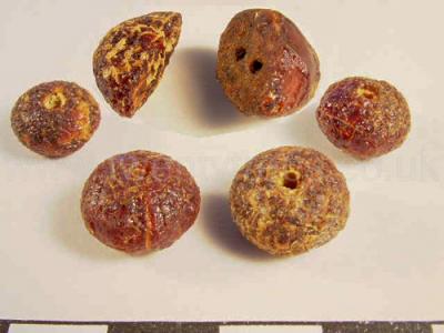
Colt Hoare 1812. No. 18 [Map], contains within its area three small tumuli, in each of which, at the depth of 18 inches, we found interments of burned bones. In the largest, which is in the centre, was a small urn, and two or three large beads of amber, in the form of half a circle and half an oval. In the second we also found two or three beads, and in the third, only burned bones.
Wiltshire Museum. DZSWS:STHEAD.48. 1 miniature (incense?) cup with thick sides, a flat rim and a sharply projecting waist but no decoration, found with a primary cremation in the central tump of three tumps in disc barrow Winterbourne Stoke G14 [Map] (?), excavated by William Cunnington.
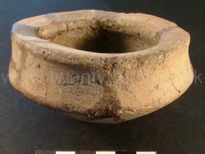
Wiltshire Museum. DZSWS:STHEAD.99 1 miniature cup (or incense cup) with three lines of cord impressions around a thick collared rim and one below and diagonal cord impressions on the thick rim top found with a primary cremation in central tump of three tumps in disc barrow Winterbourne Stoke G14 [Map] (?), excavated by William Cunnington.
Wiltshire Museum. DZSWS:STHEAD.249a. 4 amber beads and 2 V-perforated amber buttons (like shale buttons) created by splitting a large amber bead in half, found with primary cremations in two tumps (out of three) in disc barrow Winterbourne Stoke G14 [Map] (?), excavated by William Cunnington.
Europe, British Isles, South-West England, Wiltshire, Stonehenge Landscape, Stonehenge Barrows, Winterborne Stoke Barrows, Winterbourne Stoke Barrows, Winterbourne Stoke Barrow 19 G13 [Map]
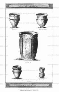
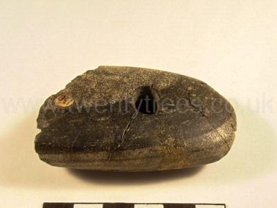
Colt Hoare 1812. No. 19 [Map], This tumulus measures 97 feet in diameter, and 7 feet in elevation. At the depth of nearly three feet, we discovered a sepulchral urn covering a little pile of burned bones1, and almost immediately under them, lay a skeleton; but before the workmen came to the urn, they had found two interments of burned bones in the east and west corners of their sections. At the depth of seven feet, viz. on the floor of the barrow, lay a skeleton, with its head towards the west, and near it was a small oblong cist, without any deposit in it. Amongst the earth thrown out of this barrow, we found a perforated pebble-stone, about two inches long, and very neatly polished; it has one corner broken off, and some cracks, as if it had been burned. It does not appear suited either to domestic or military purposes. The Britons seem to have attached particular qualities co certain stones; and this, probably, may have been suspended as an amulet from the neck.
Note 1. See Tumuli Plate XVI.
Wiltshire Museum. DZSWS:STHEAD.130. 1 polished stone macehead of greenstone, ground to an oblong oval shape and pierced by a small, almost central, hole (unfinished), from material in Bowl Barrow G13 Winterbourne Stoke [Map], excavated by William Cunnington.
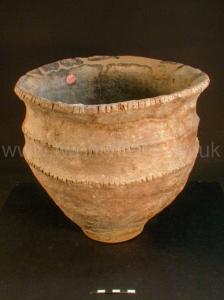
Wiltshire Museum. DZSWS:STHEAD.249. 1 Enlarged food vessel with flared notched rim (with vertical cuts) and 2 similar notched shoulder rims and small base found with secondary cremation in bowl barrow Winterbourne Stoke G13 [Map], excavated by William Cunnington.
Europe, British Isles, South-West England, Wiltshire, Stonehenge Landscape, Stonehenge Barrows, Winterborne Stoke Barrows, Winterbourne Stoke Barrows, Winterbourne Stoke Barrow 20 G12 [Map]
Colt Hoare 1812. No. 20 [Map] is a pond barrow; and No. 21 [Map], from the fragments of burned bones dispersed promiscuously about the soil, affords sufficient evidence of a prior opening.
Europe, British Isles, South-West England, Wiltshire, Stonehenge Landscape, Stonehenge Barrows, Winterborne Stoke Barrows, Winterbourne Stoke Barrows, Winterbourne Stoke Barrow 21 G11 [Map]
Colt Hoare 1812. No. 20 [Map] is a pond barrow; and No. 21 [Map], from the fragments of burned bones dispersed promiscuously about the soil, affords sufficient evidence of a prior opening.
Europe, British Isles, South-West England, Wiltshire, Stonehenge Landscape, Stonehenge Barrows, Winterborne Stoke Barrows, Winterbourne Stoke Barrows, Winterbourne Stoke Barrow 22 G6 [Map]
Colt Hoare 1812. No. 22 [Map]. The interment which this barrow contained, presented some kind of novelty and variety. It appeared as if the native turf had been first taken off, the body placed on the chalk, and a large conical pile of flints raised over it. From finding some of the bones above the floor, and amongst the flints, we might almost be led to suppose, that the Briton here interred, had suffered a similar death to that of Achan.1 The skeleton was laid from north to south, and from the size of the bones: appeared co be that of a young person, or a female.
Note 1. And all Israel stoned him with stones and they raised over him a great heap of stones." Joshua, Chap. vii.
Europe, British Isles, South-West England, Wiltshire, Stonehenge Landscape, Stonehenge Barrows, Winterborne Stoke Barrows, Winterbourne Stoke Barrows, Winterbourne Stoke Barrow 23 G7 [Map]
Colt Hoare 1812. No. 23 [Map] and No. 24 [Map] turned out unproductive.
Europe, British Isles, South-West England, Wiltshire, Stonehenge Landscape, Stonehenge Barrows, Winterborne Stoke Barrows, Winterbourne Stoke Barrows, Winterbourne Stoke Barrow 24 G7a [Map]
Colt Hoare 1812. No. 23 [Map] and No. 24 [Map] turned out unproductive.
Europe, British Isles, South-West England, Wiltshire, Stonehenge Landscape, Stonehenge Barrows, Winterborne Stoke Barrows, Winterbourne Stoke Barrows, Winterbourne Stoke Barrow 26 G9 [Map]
Colt Hoare 1812. No. 26 [Map] is a fine bowl-shaped barrow, 97 fret in diameter, and nine feet and a half in elevation. Mr. Cunnington attempted to open it in the year 1804, but missed the interment, when, as it turned out, he was within one foot of it. Fortune now favoured our researches, and discovered to us in an oblong cist, a skeleton lying from north to south, within a shallow case of wood, of a boat-like form. Round its neck were found a great variety of amber and jet beads, a lance head, and pin of brass, with a little urn of a very neat form, which was broken to pieces.
Europe, British Isles, South-West England, Wiltshire, Stonehenge Landscape, Stonehenge Barrows, Winterborne Stoke Barrows, Winterbourne Stoke Barrows, Winterbourne Stoke Barrow 27 G10 [Map]
Colt Hoare 1812. No. 27 [Map]. This large tumulus is about 90 feet in its base diameter, and in elevation seven. has several depressions on the top, from which, and the discoveries made in it. I am inclined to think it must have been a family sepulchre. We commenced our researches by making a large section from east to west, and at the depth of two feet (though at some distance from each other), found the skeletons of two dogs, as we conjectured, but being deposited in the vegetable earth, they were much decayed. At the depth of seven feet, we came to the floor of the barrow, where we discovered a large oblong cist, five feet long, four feet wide, and two and a half feet deep, neatly cut in the chalk; and on clearing away the earth round Lhis cist, we perceived a sepulchral urn inverted in a half circle, cut in the side the large cist, which, on taking out, we found had been placed in the lap of a skeleton, which lay at the depth of about a foot within the cist, its head towards the north. The urn contained burned bones, and was of a very rude make, but from the pressure of the earth was broken in two pieces. On removing it and the skeleton, we found five more skeletons lying almost side by side; two of which were young persons; and when we reached the floor of the cist, we found, what I consider to be the primary interment, viz. two skeletons lying by the side of each other, with their heads to the north, and both extremely well preserved. One of them (from the size of the bones), was a tall and stout man; all their teeth were very firm, and remarkably even. At their head was placed a drinking cup. From the manner in which these several bodies were interred, and from the position of the urn, containing the burned bones, we had positive proof that the two different modes of burial had been practised in this barrow at different periods; also that the urn was deposited at a period subsequent to the other interments; for after interring the first bodies on the floor of the cist, the vast quantity of chalk dug out of it, was again thrown in to cover them, and this chalk would naturally rise above the level of the adjoining soil. When the other bodies were interred at a subsequent period, the vegetable mould, of which the tumulus was composed, was dug through, as also about a foot or more of the chalk out of the original cist; and after depositing the latter bodies over the original interment, the earth mixed with the chalk, would be thrown over, and being thus mixed, would make a line of distinction, being different in colour to the vegetable mould composing the tumulus and the chalk out of the cist; and this distinction was very obvious. That the urn containing the burned bones the third deposit, we have also sufficient proof, as all the earth that covered it, as well as that corner of the cist in which it stood, was vegetable mould. To the north of this group, are two very small mounds scarcely elevated above the surface, which produced nothing worthy of notice.
Wiltshire Museum. DZSWS:STHEAD.274. 1 Long Necked Beaker decorated with three bands of incised and three bands of comb impressed vertical lines and one rough band of double incised zigzags, found with two primary inhumations in bowl barrow Winterbourne Stoke G10 [Map], excavated by William Cunnington.
