Food Vessel
Food Vessel is in Prehistoric Artefacts.
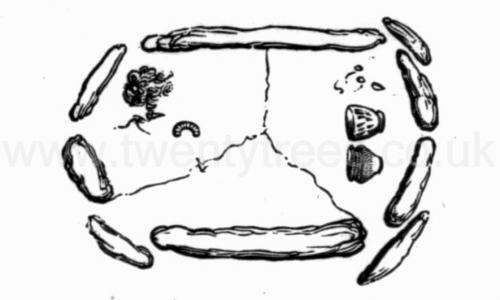
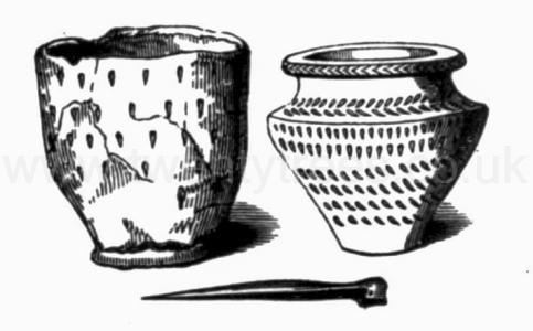
John Lubbock 1879. He commenced by cutting a trench across the barrow [Map] from the south side. In the operation a shoulder-blade and antler of red deer were discovered, and also a number of water-rats' bones. On reaching the highest part of the tumulus, which was elevated about four yards above the natural soil, a large flat stone was discovered, about five feet in length, by three feet in width, lying in a horizontal position, about eighteen inches above the natural floor. This stone was cleared, when a small six-sided cist was exposed, constructed of ten limestone blocks, which were placed on one end, and having a floor of three similar stones. The chamber was quite free from soil, the cover having prevented the entrance of earth, and protected the contents, which were a quantity of calcined human bones, strewed about the floor of the cist; amongst which were found a rude kidney-shaped instrument of flint, a pin made from the leg-bone of a small deer, and a piece of spherical iron pyrites. At the west end of the cist were two ornamented, but dissimilar, urns of coarse clay. One had fallen to pieces, but has since been restored, and is of an elegant form; the other was taken out quite perfect, and is of much ruder design and workmanship. In addition to these urns, a piece of the ornamented upper edge of another vase, quite unlike the others, was found, The floor of the chamber was laid - the natural soil, and the cist was strewed with rats' bones, both within and without. The pin had probably been used as a brooch, while the flint and iron pyrites, which have been found in association in other barrows, probably served for procuring fire. The urns belong to the type which have been called food vessels, to distinguish them from the cinerary urns in which the ashes of the deceased were placed. They may have contained two sorts of food, or food and drink; or, as Mr. Bateman supposes, the presence of two may indicate a double burial.
Wiltshire Archaeological Magazine 1907 V35 Pages 1-20. There are several recorded instances where urns of a characteristic cinerary type have apparently been used to contain food offerings instead of the more usual form of food vessel or drinking cup2; there are also instances where the food offering appears to have been placed at a considerable distance from the resting-place of him to whose service it was dedicated3.
Note 2. "On Langton Wold, and in a few cases, a vessel which is in every respect of form and ornament a cinerary urn was placed close to an unburnt body, "British Barrows, p. 62. "Not infrequently a food vessel is of the cinerary urn type, though its size is that of an ordinary food vessel. And in rare instances a real cinerary urn, both in size and type, seems to have been used as a food vessel, and placed near a heap of burnt bones, and not containing them," J. E. Mortimer, Burial Mounds of East Yorkshire, p. liv.
Note 3. Mr. J. R. Mortimer says:- "We have in several instances found vases which had every appearance of having been deposited with food in them, where no trace of an interment could be discovered," Burial Mounds of East Yorkshire, p. 55 (note); see also ibid,pp.l07. 314 (Barrow 247), 316 (Barrow 250), 323 (barrow c. 90.)
Wiltshire Archaeological Magazine 1907 V35 Pages 1-20. No. 17. Nine feet almost due south of the skeleton and 1ft. 2in. below the present surface, a vessel of the cinerary urn type was disclosed. It had been crushed into several pieces by the weight of the earth above, and was also slightly damaged by the workman's pick; it has, however, been repaired and is now complete. It stood in an upright position, but with no signs of ashes or of burnt material of any sort inside it, nor was there any sign of an interment, burnt or unburnt, near it1. Immediately beneath it the earth was a little reddened and discoloured as if by fire, and there were a few specks of charcoal; but the traces of fire were slight, and quite local. The vessel might be chosen as typical of a cinerary urn from its general shape and heavy overhanging rim, which latter feature Canon Greenwell (age 86) says may be regarded as the principal characteristic of this class of urn2. But in spite of its form, as it contained no bones or ashes, one is forced to the conclusion that it may have served the purpose of a food vessel, and that it had probably contained some form of food offering made to the dead at some time subsequent to the burial, and during or after the piling up of the barrow.
Note 1. Canon Greenwell (age 86) says: "In a few instances a sepulchral vase has occurred in a barrow not in close proximity with any interment," British Barrows, p. 61.
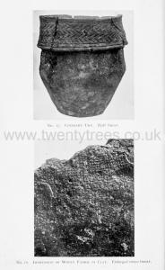
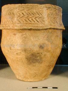 Collared urn decorated with vertical lines around rim and 2 rows of cord impressed chevrons around collar bordered by two cord impressed lines at top and bottom, found upright in cist with no cremated remains. Collection of [Map].
Winterbourne Stoke Crossroads Long Barrow [Map]. Historic England 1011841.
The monument includes a Long Barrow north east of Winterbourne Stoke crossroads, situated on a south west-north east ridge and having extensive views to the south east across Wilsford Down and Normanton Down. The long barrow is orientated south west-north east along the ridge and forms the origin and focal point of a linear round barrow cemetery which extends some 500m along the ridge to the north east and contains a total of 22 round barrows. The barrow mound is 95m in length, 22m wide, and 2.5m high. It is flanked on the north west and south east by ditches running the length of the mound from which material was quarried during its construction. The north west ditch is 1m deep and c.8m wide. The south east ditch is visible in part, having become largely infilled over the years, but its full width is visible as a vegetation mark on aerial photographs from which it is calculated to be c.10m wide. The long barrow is therefore 95m long and 40m wide. Partial excavation in the 19th century revealed a primary male inhumation with a flint implement, and six secondary inhumations with a plain food vessel 0.75m from the top of the mound.
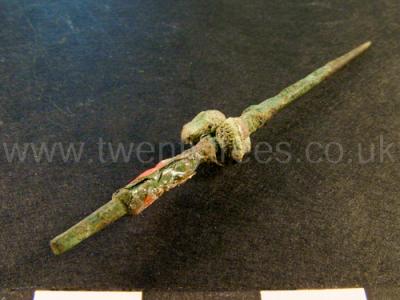
Wiltshire Museum. DZSWS:STHEAD.228. 1 bronze awl with a square tang and fragments of a bone handle attached, found with a primary cremation (female?) inside an Enlarged food vessel urn in bowl barrow Winterbourne Stoke G28 [Map], excavated by William Cunnington.
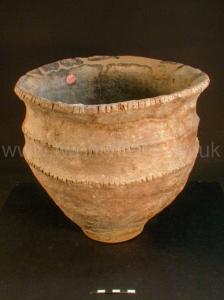
Wiltshire Museum. DZSWS:STHEAD.263. 1 food vessel with wide spreading rim containing stab marks and two ridges notched with finger impressions around waist, found inverted over a secondary cremation near the surface in bowl barrow Winterbourne Stoke G24 [Map], excavated by William Cunnington.
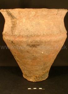
Wiltshire Museum. DZSWS:STHEAD.356. 1 food vessel, undecorated thick ware with a square flared rim and slight waist rim, found with secondary cremation in barrow Durrington H35, unlocated, excavated by William Cunnington.
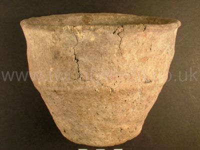
Wiltshire Museum. DZSWS:STHEAD.249. 1 Enlarged food vessel with flared notched rim (with vertical cuts) and 2 similar notched shoulder rims and small base found with secondary cremation in bowl barrow Winterbourne Stoke G13 [Map], excavated by William Cunnington.
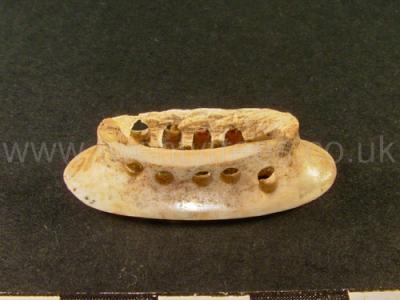
Wiltshire Museum. DZSWS:STHEAD.86a. 1 bone pommel with 5 rivet holes in both sides and two in the end found with a primary cremation (in an upright food vessel) in bowl barrow Winterbourne Stoke G66 [Map], excavated by William Cunnington.
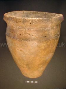
Wiltshire Museum. DZSWS:STHEAD.264. 1 Enlarged Food Vessel with a band of chevrons around the neck, two bands around the outer rim, one band around the inner rim and bands of diagonal lines around the rim, waist and base, found with a primary cremation (female?) inside in bowl barrow Winterbourne Stoke G28 [Map], excavated by William Cunnington.
Fin Cop, Derbyshire [Map]. Historic England 1011205
Fin Cop is a steep-sided promontory situated on the western edge of Longstone Moor on the limestone plateau of Derbyshire. The monument occupies the north-west corner of the promontory, overlooking Monsal Dale to the north and Wye Dale to the west. It includes a Late Bronze Age or Early Iron Age promontory fort and, within the area covered by the fort, an Early Bronze Age bowl barrow and an eighteenth century limekiln with an attached limestone quarry. The promontory fort comprises a level sub-rectangular area defined on the north and west sides by the steep scarps above the two dales and on the east and south sides by earthwork defences. Starting on the edge of Monsal Dale to the north, these defences extend southwards for 225m then curve south-west for a further 160m before ending on the edge of Wye Dale. From this point, a linear feature extends northwards back to the edge of Monsal Dale and is interpreted as the site of the timber palisade that would have enclosed the fort on this side. It consists of a low bank with a narrow berm or terrace to the west and then a slight counterscarp bank. It appears, wholly or partly, to have utilised a natural break in the limestone outcrop. The earthwork defences round the landward edge of the fort consist, for the northernmost 180m, of a bank, ditch and counterscarp bank, then, for the rest of the circuit, of a bank or rampart only. The more massive inner bank is currently c.5m wide by 1.5m-2m high, the ditch is c.3m wide by 1m-1.5m deep and the counterscarp bank is c.2m wide by 1m high. Although no longer visible, it is likely that the ditch extended round the southern section of the rampart and has become silted up and levelled by ploughing since the fort was abandoned. Together with the remains of the counterscarp bank, it will survive as a buried feature and is included within the scheduling. A gap in the double bank and ditch on the east side indicates the original entrance into the fort. Near the western edge of the fort, just north of the eighteenth century quarry, are the ploughed over remains of an earlier Bronze Age bowl barrow. The barrow was quarried for its stone in the late eighteenth century, possibly to feed the adjacent lime kiln. Subsequently, in 1795, it was partially excavated by Rooke. His discoveries included a rock-cut grave built up with stone and covered by a capstone. Inside was a disarticulated skeleton accompanied by two flint arrowheads. Elsewhere in the mound, he found a dry-walled cist, or grave, containing the remains of a cremation, while, on the south-east side three pottery 'urns' were discovered, one of which has since been identified as a ceremonial food vessel. These contained further cremations and one of the 'urns' also contained an arrowhead. Two further inhumations were found on the east side of the mound. In its present disturbed condition, the barrow has a diameter of 24m by 23m and a height of c.0.5m though, originally it would have been between 1m and 2m high. Roughly 20m to the south is an eighteenth century lime kiln set in its own small quarry. The kiln is of the type known as a 'double pye-kiln'. The modern field walls crossing the monument are excluded from the scheduling though the ground beneath is included.
Bull Ring Henge [Map]. Historic England.
The monument is situated on the north-western edge of the limestone plateau of Derbyshire and includes, within a single area, Bull Ring henge and the adjacent oval barrow. Also included is the bowl barrow superimposed on the western end of the oval barrow. The henge has an external diameter of 93m by 90m and comprises a bank and internal quarry ditch surrounding an oval area measuring 53m from north to south by 46m from east to west. The steep-sided rock-cut ditch currently varies between 8m and 12m wide and between 0.5m and 1m deep. Partial excavations carried out by Alcock in 1949, demonstrated that, originally, it measured 5m to 6.5m wide and was between 1.2m and 2.1m deep. The surrounding bank is currently c.1m high and between 9m and 11m wide. It has spread since its construction, however, and was originally 2m high and 5.5m to 7m wide. It is broken by opposing entrances to north and south, each with a causeway across the ditch and each measuring c.9m wide. The northern example was damaged by quarrying in the nineteenth century, when a human skeleton was reputedly found. Between the bank and ditch is a berm or terrace which originally measured 5m wide and is clearly visible in the southern part of the site. Northwards, it becomes narrower and is finally obscured by the spread material of the bank. The interior of the henge contains the linear earthwork remains of eighteenth century ploughing which, to the west of the northern entrance, has partially levelled the inner edge of the ditch. Also during the eighteenth century, a drystone wall crossed the site and has since been removed though the line of it can still be seen as a gap in the plough ridges. Pilkington, writing in 1789, records that a single orthostat of a possible stone circle remained within the henge. This has gone and no investigation of the interior of the henge has been carried out to confirm whether or not a stone circle existed. In addition to Alcock's excavations of the ditch and bank, a minor excavation was carried out in the west ditch by Salt in 1902 and, in 1984, a larger excavation by Barnatt and others took place outside the south entrance. Material recovered by Salt has been lost but is reported to have included pottery sherds and flint flakes, while Alcock found further flint flakes and artefacts and a rim from a pottery food vessel. The 1984 excavation confirmed that the area south of the henge had been disturbed in the post-medieval period, but several pits and the stakeholes of a hurdle fence which followed the henge bank are undated and may be contemporary with the henge. In addition to post-medieval material and a sherd of Roman pottery, numerous flint flakes and implements were also found in this area. On the south-west side of the henge, c.20m distant, is a large mound interpreted as an oval barrow overlain on its western end by a later bowl barrow. It is sub-rectangular in shape and measures 27m by 21m by c.2.5m high. Originally it would have been somewhat higher but has been disturbed on the summit by a World War II slit trench. Its current plan is due to modern disturbance round its edges, caused by ploughing and the construction and later removal of drystone walls on its east and north sides. No recorded excavation of the barrow has been carried out so it cannot be precisely dated. However, it's position and form are analogous with those of Gib Hill: the superimposed oval barrow and bowl barrow at nearby Arbor Low henge. All modern walls and fences and the surfaces of the track and carpark round the outside of the monument are excluded from the scheduling although the ground beneath these features is included.
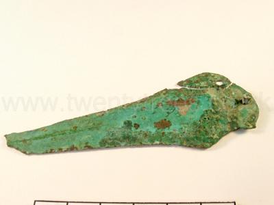
Wiltshire Museum. DZSWS:STHEAD.86. 1 bronze knife dagger with 3 rivet holes and one rivet remaining (broken in three places) found with a primary cremation (in an upright food vessel) in bowl barrow Winterbourne Stoke G66 [Map], excavated by William Cunnington.
