North England Stone Circles
North England Stone Circles is in Prehistoric North England, Stone Circles.
Europe, British Isles, North-West England, Cumberland, Ulverston, Birkrigg Stone Circle [Map]
Birkrigg Stone Circle [Map] is two non-concentric Stone Circles, the outer measuring 26 m and consisting of 15 stones and the inner being 9 m wide and consisting of 10 stones. None of the stones is more than 0.6m tall. A well defined trench of unknown origin runs close on the North side. An excavation was conducted Sept 1911 by the North Lonsdale Field Club. The area of both circles was found to be roughly paved with cobbles. Four cremations were unearthed from the inner circle, a fifth beneath an inverted cinerary urn and a sandstone disc was found. A second excavation, 1921, generally confirmed the above and produced a few small stone implements of dubious classification. The date of its construction and use is uncertain.
Europe, British Isles, North-West England, Westmoreland, Ainstable, Broomrigg Prehistoric Site, Broomrigg Stone Circle A [Map]
Broomrigg Stone Circle A [Map]. The monument includes a large irregular stone circle known as Broomrigg A together with an associated double stone alignment. Approximately 55m in diameter of which only the north western arc of stones still remain largely in situ. Of these surviving stones three stand between 0.5m-0.9m high; elsewhere stones have either been removed or are loose and their positions are no longer thought to reflect their original location. Limited excavation of the circle by Hodgson in 1950 found that the socket holes for the stones had been carefully made and packed with small stones. The stones of the circle were set c.0.25m into the ground.
Europe, British Isles, North-West England, Westmoreland, Ainstable, Broomrigg Prehistoric Site, Broomrigg Stone Circle B1 [Map]
Broomrigg Stone Circle B1 [Map]. Historic England:A circle originally of seven stones, of which only four now remain, enclosing an area approximately 3.4m in diameter. Of the surviving stones three remain upstanding and are of red sandstone, the fourth is of a light-coloured sandstone and has fallen outwards. A slight turf-covered mound within the circle indicates that the stones originally encircled a burial cairn. Excavation by Hodgson in 1950 found a large stone-lined central burial pit measuring 1.6m in diameter by 0.53m deep. This pit would have held the primary burial but it had been robbed in antiquity and all that remained was a small flint flake. The socket holes for the three missing stones were also located and behind one of these was a small shallow pit c.0.3m in diameter containing charcoal and bones of a secondary burial. The excavation also found a block of rounded sandstone with a design of crossed lines incised into its face.
Europe, British Isles, North-West England, Westmoreland, Ainstable, Broomrigg Prehistoric Site, Broomrigg Stone Circle C [Map]
Broomrigg Stone Circle C [Map]. Historic England: A circle of 14 stones which enclose an internal area measuring approximately 16m east-west by 13m north-south. Limited excavation of the circle by Hodgson in 1948-9 found a burial cairn in the south west quadrant of the circle which covered a deep pit containing a stone cist composed of sandstone slabs. A short distance to the east a smaller disturbed cist was found. In the cairn's south east quadrant remains of several cremation burials were found together with urns and a number of grave goods including jet beads, a button and a bronze knife or awl. The excavator concluded that a small stone circle of 4.3m in diameter and represented by the remaining stones in the south west quadrant was the earliest construction here. A pit was dug in the centre, and an interment placed in a cist within; a cairn was then raised over the grave. At a later date the stone circle was demolished, apart from the south west arc, which was incorporated into the present surviving larger circle. More interments were then placed within this later circle. At the time of the excavation there was an outlying stone 14.5m south east of the circle's centre.
Europe, British Isles, North-West England, Westmoreland, Ainstable, Broomrigg Prehistoric Site, Broomrigg Stone Circle D [Map]
Broomrigg Stone Circle D [Map]. Historic England: A circle of six stones enclosing an oval area measuring approximately 5.2m north east-south west by 3.8m north west- south east. The largest stone lies prostrate on the western side of the circle; it measures 1.6m long but may never have been erect as no socket hole has been found for it. A plan of the circle drawn in 1934 shows eight stones forming the circle at that time. By the time the circle was excavated by Hodgson in 1960 the stones had been reduced to six in number. This excavation found a socket hole for a missing stone on the circle's northern side, three small sherds of undecorated hand-made pottery, and a number of worked flints, one of which was a blade 6cm long.
Europe, British Isles, North-West England, Cumberland, Boot, Burnmoor Stone Circles
The Burnmoor Stone Circles are a group of five Stone Circles located near the village of Boot, Cumberland in Cumbria. There date is given as 2000BC; the evidence for this date is unkwown? Burnmoor contains approximately 403 cairns. Some are round in shape and range in diameter between 1.35 - 6.9 meters in diameter and 0.1 - 0.65 meters high, some are oval in shape and range between 2.9 meters long by 1.6 meters wide and 10.25 meters long by 3.9 meters wide and 0.1 - 0.9 meters high.
Europe, British Isles, North-West England, Cumberland, Boot, Burnmoor Stone Circles, Brat's Hill Stone Circle [Map]
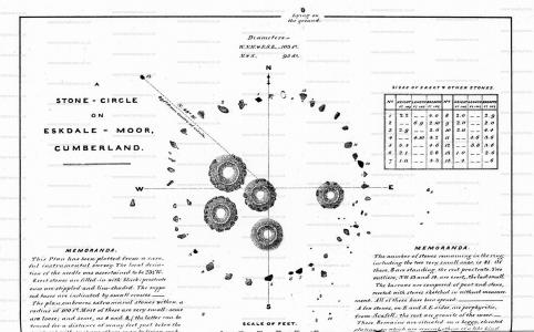
Brat's Hill Stone Circle [Map] is a circle of around forty-two stones of dimensions 32 x 25.9m. Note. The National Trust record states "Of the five stone cirlces Brat's Hill is the largest with approximately 42 stones forming an irregular circle with an average diameter of 10.4 meters."
Cumbria and Westmorland Antiquarian and Archaeological Society. Brat's Hill Stone Circle [Map]. This, though the finest, is only one of several similar remains on the same moor. About 100 yards to the west, are two smaller rings in an imperfect state, each about 50 feet in diameter, and each inclosing one barrow. A quarter of a mile west-northwest, on Low Longrigg, are two others; one apparently perfect, about 50 feet in diameter, consisting of nine stones, and inclosing one barrow; the other imperfect, with diameters of about 75 feet and 65 feet, and inclosing two barrows. A number of ancient "dykes," each consisting of a slight ditch and embankment, intersect the moor, near these remains.
Europe, British Isles, North-West England, Cumberland, Boot, Burnmoor Stone Circles, Low Longrigg Circles
Europe, British Isles, North-West England, Cumberland, Boot, Burnmoor Stone Circles, White Moss Circles
Castlerigg Stone Circle
Avebury by William Stukeley. Castlerigg [Map]
We continued our journey through this rough country, and passed half round the bottom of the famous Skiddaw, a high mountain named from its fancied likewise to a shoe (ysoyd.) Penruddoc, a town near it, with a Welsh name. These desolate and hilly regions were the retiring places of the Britons from the power of the Romans; which perhaps is the reason of the great number of temples scattered throughout the country; for a mile before we came to Keswick, on an eminence in the middle of a great concavity of those rude hills, and not far from the banks of the river Greata, I observed another Celtic work, very intire: it is 100 foot in diameter, and consists of forty ftones, some very large. At the east end of it is a grave, made of such other stones, in numfer about ten: this is placed in the very east point of the circle, and within it: there is not a stone wanting, though some are removed a little out of their first station: they call it the Castles, and, corruptly I suppofe, Castle-rig. There seemed to be another larger circle in the next pasture toward the town.
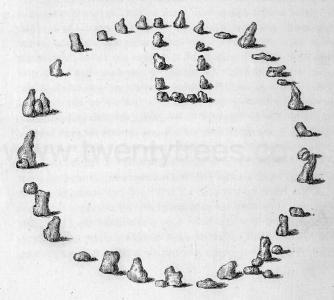
1772. Thomas Pennant. "A tour in Scotland, and voyage to the Hebrides, 1772": Castlerigg Stone Circle [Map]: "In the course of the descent, visit, under the guidance of Doctor Brownrigg (the first discoverer) a fine piece of antiquity of that kind which is attributed to the Druids. An arrangement of great stones tending to an oval figure, is to be seen near the road side, about a mile and a half from Keswick, on the summit of a pretty broad and high hill, in an arable field called Castle. The area is thirty-four yards from north to south, and near thirty from east to west; but many of the stones are fallen down, some inward, others outward: according to the plan, they are at present forty in number. At the north end, are two much larger than the rest, standing five feet and a half above the soil: between these may be supposed to have been the principal entrance; opposite to it, on the S. side, are others of nearly the same height; and on the east is one near seven feet high. But what distinguishes this from all other Druidical remains of this nature, is a rectangular recess on the east side of the area, formed of great stones, like those of the oval. These structures are considered in general to have been temples, or places of worship: the recess here mentioned seems to have been allotted for the Druids, the priests of the place, a sort of Holy of Holies, where they met separated from the vulgar, to perform their rites, their divinations, or to sit in council, to determine on controversies, to compromise all differences about limits of land, or about inheritances, or for the tryal of the greater criminals1; the Druids possessing both the office of priest and judge. The cause that this recess was placed on the east side, seems to arise from the respecy paid by the antient natives of this isle to that beneficent luminary the sun, not originally an idolatrous respect, but merely as a symbol of ths glorious all-feeing Being, its great Creator.
Note 1. Cæf. de Bello Gal. lib. vi.
1819. Castlerigg Stone Circle [Map]. Samuel Taylor Coleridge (age 46): "a Druidical circle [where] the mountains stand one behind the other, in orderly array as if evoked by and attentive to the assembly of white-vested wizards" (1799) and Keats "Scarce images of life, one here, one there,/Lay vast and edgeways; like a dismal cirque/Of Druid stones, upon a forlorn moor…"
Cumbria and Westmorland Antiquarian and Archaeological Society. Castlerigg Stone Circle [Map]. It has been the fashion to class this with the temples of the prehistoric ages. The magnificence of its site, and the rectangular inclosure on the eastern side,—which has been thought to be an adytum, foreshadowing the chancel of a Christian church,—have lent strength to the idea. In the present imperfect state of our knowledge on this subject, it is, however, well to refrain from using technical terms which involve the advocacy of premature theories; and to confine ourselves to such as are simply descriptive of that which meets the eye. Nothing now remains to show for what purpose this chamber was constructed. If it once contained a barrow, all traces of such an object have disappeared. A shallow circular trench, shown on the plan, within the stone-ring, but outside this chamber, at first sight looks like the remains of a barrow; but as the field was ploughed little more than a century ago, and, perhaps, continued to be for many years, it is probable that this trench is still more recent.
Cumbria and Westmorland Antiquarian and Archaeological Society. ART. V. Some recent Observations at the Keswick Stone Circle [Map]. By W. D. ANDERSON. Read at Carlisle, July 2nd, 1914. The various prehistoric structures which have been generically termed "Stone Circles" may be conveniently divided into three classes:-
(1) Those which have been built for sepulture, such as the Circles at Eskdale and Muir Divock;
(2) Those built for strategic purposes, such as the Circle at Carrock, Mosedale;
(3) Those which seem to have been built primarily for astronomical and religious use.
The Circle on Castlerigg [Map], near Keswick, seems to belong to this last class, and its old name, "The Druid Circle," may be a rational designation. Most authorities are agreed that these Circles date from pre-Celtic times, and many think that the Druids belonged properly to this period, but the Celtic-speaking peoples called their priests "Druids" and there is evidence to show that the Circle at Keswick was used for religious purposes in Celtic times.
Europe, British Isles, North-West England, Cumberland, Embleton, Elva Plain Stone Circle [Map]
Elva Plain Stone Circle [Map]. Historic England: The monument includes a large regular stone circle of 15 pink granite boulders located on a relatively level terrace on the southern slopes of Elva Hill 240m ENE of Elva Plain. The arrangement of stones forms an almost perfect circle with an internal diameter of 33.5m. The 15 stones are all that remain visible of an original number of about 30; of these, those in the north east quadrant are level with the ground, one on the east side has recently become partly buried, and the remainder of the stones have fallen, with the possible exception of the stone due west of centre which stands to a height of 0.7m.
Cumbria and Westmorland Antiquarian and Archaeological Society. ARTICLE IV. Elva Stone Circle [Map]. By W. D. ANDERSON. Read at Carlisle, April 6th, 1922. This Circle is situated 1½ mile due W. of the N. end of 1 Bassenthwaite Lake. It stands about 470 feet abovethe sea level, on a plateau called Elva Plain, S.E. of Elva Hill.
At present the Circle consists of 15 stones and an outlier, whose positions are indicated on the plan and their apparent dimensions on a separate table (pp. 32, 33). In 1913 the stone marked "5a" was covered by turf, but it has since come into view. This would suggest that there may be others out of sight. Four of the stones are flush with the ground and four others are less than 1 ft. above the surface. It seems probable that these eight stones have sunk, but to determine this point, perhaps some excavation might be necessary.
Europe, British Isles, North-West England, Cumberland, Orton, Gameslands Stone Circle [Map]
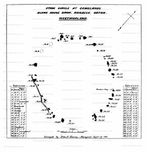
Gameslands Stone Circle [Map]. Historic England: Earthwork remains of a Neolithic embanked stone circle. 19th century excavation may have uncovered part of a cist in the centre of the circle. Surveyed in 1966 by N Ward and W N Rodgers, the "Circle" consists of some 30 granite-like boulders, arranged in the form of an ellipse, with an E-Waxis of about 140' and a N-W axis of about 125'. Not easy to tell whether the stones have ever been in a standing position. No sign of stones, nor of any mound, at or near the centre. There might possibly have been an 'entrance' at the south. Two worked flints and a freestone slab, "possibly once part of a cist", found 1880. (1-3). Surveyed in 1966 by N Ward and W N Rodgers, the "Circle" consists of some 30 granite-like boulders, arranged in the form of an ellipse, with an E-Waxis of about 140' and a N-W axis of about 125'. Not easy to tell whether the stones have ever been in a standing position. No sign of stones, nor of any mound, at or near the centre. There might possibly have been an 'entrance' at the south. Two worked flints and a freestone slab, "possibly once part of a cist", found 1880. (1-3)
Cumbria and Westmorland Antiquarian and Archaeological Society. ARTICLE. XVIII. — Stone Circle at Gamelands [Map], Bland House Brow, Township of Raisbeck, Parish of Orton, Westmorland. By R. S. FERGUSON, F.S.A. Read at Penrith, January 20th, 1881.
During the summer of 1880, one of our members, (Miss Bland, author of "A Link between two Westmorlands1,") requested me, at her expense, to have surveyed for the purposes of this Society the important stone circle, whose site is defined (rather in pedantic manner, some may think) at the head of this paper. I secured the services of Mr. J. Robinson and Mr. J. B. Harvey, and armed with a photograph, and guided by Colonel Burn of Orton Hall, we reached the proper place, where a labourer was in waiting; Canon Weston also joined us.
Note 1. Transactions, vol. 5, between pp. 24 and 25.
Cumbria and Westmorland Antiquarian and Archaeological Society. Dr. Burn lived within five miles of the place, but he took no interest in such remains; the stone circle at Gamelands [Map] is within a mile of his house; he does not even mention it in his history, yet it is one of the most important in England. No wonder, then, that his account of the Shap Stones is inaccurate, and that he made no plan of them. But even so long ago as his day the era of destruction had set in. He says the common people had used several of the stones as foundations of houses, and cut up others into millstones.
Europe, British Isles, North-West England, Westmoreland, Ainstable, Grey Yauds Stone Circle [Map]
Grey Yauds Stone Circle [Map]. Historic England: Despite the loss of much of the standing remains of Grey Yauds Stone Circle one monolith remains standing and the size of the removed stones indicates that there will be below ground archaeological deposits within features such as stone sockets that will relate to the construction, use and abandonment of the stone circle. The monument is of a rare and highly important monument type and is particularly characteristic of its period. The monument provides insight into the importance of ritual observance and the character of cosmology during the Late Neolithic/Bronze Age periods.
Europe, British Isles, North-West England, Cumberland, Shap, Gunnerkeld Stone Circle [Map]
Gunnerkeld Stone Circle [Map]. Historic England:
The monument is Gunnerkeld concentric stone circle which is located 200m south-west of Gunnerwell Farm on the top of a slight ridge. The monument includes an outer circle measuring c.30m north-south by 24m east-west of 19 large granite stones, threeof which are upright and just over 1m tall. There is an entrance on the northern side of the outer circle between two of these large stones. Within the outer circle is an inner circle measuring c.18m north-south by 16m east-west of 31 granite stones. This inner circle forms the kerb of an earth and stone cairn up to 1m high. Limited antiquarian excavation of the central cairn located a stone cist.
Cumbria and Westmorland Antiquarian and Archaeological Society. ARTICLE XL.—Gunnerkeld Stone Circle [Map].1 By C. W. DYMOND, M. Inst. C.E., F.S.A.
This remarkable, though little known, megalithic monument is situated at Gunnerkeld2, a mile and a half north of Shap, in Westmorland, and four or five hundred yards off the Appleby road, where it crosses a hollow three quarters of a mile east of the point at which that road leaves the one from Shap to Penrith. The site is in the midst of a valley dipping towards the north-north-west, on a low, grassy tongue formed by a gentle depression on one side, and a little wady3 on the other. It is on the border of a region fertile in prehistoric antiquities beyond most others in Britain. A mile to the south of Shap, the remains of a fine megalithic circle may be seen close to the fence of the railway which has swept away the larger part. Proceeding northward, close to the village, are the relics of what must once have been a grand parallellithon, second only, among our insular antiquities, to those at Avebury, and trending towards two massive boulders, a furlong apart,—the farthest called Thunder Stone,—which lie on rising ground about a mile to the north-west. In another direction, a mile to the east of Shap church, poised on a brow of rock, is a third boulder which, though it may have been placed there by human hands, is much more likely to be a bloc perché, for reasons to be presently given. The chain of heights bounding the Shap valley on the east, crowned by tumuli alternating with stone circles and a British camp, looks clown into a group of inclosures, regarded as the remains of aboriginal settlements, which are scattered over the lower slopes on the other side.
Note 1. This article is reproduced by the kind permission of the author, and of the Council of the British Archæological Association, from the Journal of the Association, volume XXXV., p. 368.
Note 2. In local parlance this word simply means "Sportsman's Spring." It should properly be Gunner's Keld, but the possessive s is usually dropped by the people of the north-west country.
Note 3. There is no English equivalent.
Cumbria and Westmorland Antiquarian and Archaeological Society. To sum up the distinctive characteristics of "Sunken Kirk [Map]":—it is a circle with stones in close order, each set in a bed of small stones, having a gateway, and yielding no evidence of having been sepulchral or connected with funeral rites.
Finally, it may be instructive to note the points of resemblance and of difference between "Sunken Kirk [Map]" and Gunnerkeld [Map]. Both are furnished with gateways; the former is not sepulchral, the latter is. The general affinities of "Sunken Kirk [Map]" are with Long Meg [Map] and Castle-rigg [Map]; those of Gunnerkeld with the double ring at Oddendale [Map].
Europe, British Isles, North-West England, Cumberland, Lamplugh Stone Circle [Map]
Lamplugh Stone Circle [Map] was
Parish of Lamplugh. On an eminence in the Stockhow Hall estate, in this parish, are the remains of a druidical circle [Map] called Standing Stones. Only the northern segment is now to be seen; the remainder having been blasted and removed a few years ago to make fences with. The part remaming consists of six large stones, of the kind provincially called the smooth blue cobble, placed at irregular distances, varying from eighteen paces to one; and the circle, when perfect, may have been one hundred paces in diameter. The stones are mostly of an oblong figure, placed endwise in the circumference of the circle; four of the largest are nearly four feet in height above ground, and are supported in an upright position by other large stones around their bases underground. The neighbouring rock is of limestone. We can ascertain no tradition relating to the stones beyond the name, which is common to similar erections in other parts of the kingdom.
Europe, British Isles, North-West England, Westmoreland, Pooley Bridge, More Divock aka Cockpit Stone Circle [Map]
Archaeological Journal Volume 18 The Shap Stones. To the south of the road from Bampton to Pooley there is a remarkable circle, about 100 feet in diameter, surrounded by stones placed close to each other, and many of them set edgeways. This circle is called the Druids' Temple, but is better known by the less dignified title of the Cockpit [Map] [More Divock aka Cockpit Stone Circle [Map]]. Near this were, until very lately, several smaller circles, and at no great distance a large flat stone about 7 feet long. I have here briefly mentioned these vestiges, as I also alluded to the interesting remains in the direction of Gunnerskeld, to show that their existence, and a knowledge of that existence, might induce a belief that there was some connection between this moor and Karl Lofts.
Cumbria and Westmorland Antiquarian and Archaeological Society. Article XXXII - The Prehistoric Remains On Moordivock [Map], Near Ullswater. — By M. Waistell Taylor, M.D., (Ed.) F.S.A., (Scot.) Communicated at Carlisle, July 23, 1885.
In the descriptions of the great peristylithic monuments of Cumberland and Westmorland, given by the old authorities, Camden, Stukely, Gough, Lysons and others, there are inaccuracies and a certain looseness of delineation, and their errors have been iterated in our county histories, and in other works in which the descriptions have been taken at second-hand. But the Transactions of this Society now afford trustworthy records for future reference. The great stone circles of Long Meg [Map], Keswick [Map], Gunnerkeld [Map], Eskdale [Map], and Broughton [Map], have been most exactly surveyed by Mr. C. W. Dymond, F.S.A., and the plans and results of his consummate and critical examinations may be found in these volumes.1 Some of the less prominent prehistoric remains existing within our district, have from time to time been treated and delineated in a perspicuous manner by various members of the Society, (to which reference may be found below,) so as to leave nothing more to be desired.2
Note 1. Group of Cumberland Megaliths. Transactions of this Society, vol. v., p. 39. Gunnerkeld Stone Circle. Transactions, vol. iv., p. 537.
Note 2. Ancient Remains at Lacra and Kirksanton—J. Ecclestone, Trans. vol. i., p. 278
British Barrow at Hackthorpe.—James Mawson, - do. vol. ii., p. II
Buried Stone Circle, Yamonside.—M. W. Taylor. - do. vol. i., p. 167
Leacet Hill Stone Circle.—Joseph Robinson - do. vol. v., p. 76
Clifton Barrows.—M. W. Taylor, - - - do. vol. v., p. 79
Stone Circle, Gamlands.—Miss Bland and R. S. Ferguson do. vol. vi., p. 183
Stone Circles near Shap.— Canon Simpson - - do. vol. vi., p. 176
Archæological Remains in Lake District.—J. Clifton Ward, do. vol. iii.. p. 241
Cairns near Kirkby Stephen and Orton.—Canon Greenwell, "British Barrows," P. 381.
Cumbria and Westmorland Antiquarian and Archaeological Society. We will now proceed to the group (b), Stone Circles on the S.W. near the old Roman road. About a third of a mile from the White Raise, close by the point at which the old Roman road crosses the rill, which goes to form the Elderbeck, there is the following circular enclosure, which is marked in the ordnance map, as the remains of a Druidical Circle.
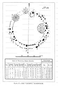
No. 13. Double Circle, "The Cockpit [Map]." This is a large prominent object, and it is well-known to those who frequent the common, under the name of the Cockpit. The remains are situated on a natural flattened ridge, and consist of a circular arrangement of boulder stones inclosing a flat area. It cannot be said to be perfectly circular, being slightly oval in circumference, the diameter N. and S. being go feet, and E. and W. 103 feet. As a plan has been furnished, (Plate IV), with the sizes of the principal stones given, and the distances between them, many of the details may be omitted in the description. A few of the stones are now doubtless dislocated from their regular bearings, some having fallen inwards and others outwards, but the observer can readily discern that there has been a carefully constructed peristylith of two rings of stones, an inner and an outer. Within the circumference there are the ruins of four segmental cairns or barrows. The most prominent of these is situated within the boundary on the E. side, where an earthern mound has been raised above the level of the plateau, and a circular cairn has been set upon it. The diameter of this heap is 24 feet, and the circular form is well maintained by stones averaging a foot square, of which about 70 remain, set in an approach to concentric arrangement. The circle at the foot of figure 1, consists of eight or ten stones in their places, and has a diameter of g feet. The cairn situated under figure 16, is flattened and nearly demolished; that under figure 15, shews the cairn structure piled up with loose stones, and so elevated above the surface.
Europe, British Isles, North-West England, Cumberland, Shap, Oddendale Stone Circle [Map]
Cumbria and Westmorland Antiquarian and Archaeological Society. 1st. Variety in the Interments. For instance an exploration of the circle No. 4. disclosed a deposit of burnt bones lying in the soil, accompanied by a food vessel; in cairn No. 5. the calcined bones and ashes had been held in a mortuary urn; whilst under the White Raise or No. 10. there was found inhumed in a stone coffin the whole skeleton in a doubled-up position.
The same story is told by Canon Greenwell and other barrow explorers, that burial by inhumation and by cremation was coeval, and was practised by the same people at the same period of time, and that the two modes of sepulture had been found existing in the vicinity of each other, or even under the same superincumbent barrow.
The recent discoveries in the neighbourhood of Penrith, in respect to the contents of prehistoric graves, indicate that in this part of the country at least, the usage of cremation and that of inhumation and cist burial were practised indiscriminately. Under the Redhill sculptured stone1, I found the cremated remains without an urn; at Moorhouses the calcined bones in an urn; within the Leacet circles2 as described by Mr. R. S. Ferguson, and Mr. Joseph Robinson, the interment had been by cremation, and there were found five cinerary urns, a food vessel, and an incense cup; whilst under the Clifton barrow we had two kist-vaens with unburnt skeletons in company with their food vessels.2 great 100 feet circle No. 13. or the 'Cockpit,' there is a higher development, which brings it into association with some of our most important megalithic monuments. Along and within the circumference of the big inclosure, there are four subordinate segmental sepulchral circles. So we find the great 100 feet Keswick circle, to contain in the same manner on its eastern side an accessory stone inclosure, and also the site of a circular barrow; the 100 feet circle at Eskdale Muir [Map] includes within its ring five circular tumuli; the 100 feet double circle at Gunner-keld [Map], has within its inner belt a segmental chamber; the same feature is presented by the analogous circle at Oddendale [Map] near Shap.
Note 1. Trans. Cumb. and West. Arche ol. Soc. vol. vi. p. no.
Note 2. Ditto. vol. v. p. 77.
Note 2. Ditto. vol. v. p. 90.
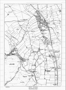
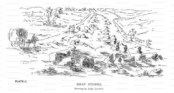
Europe, British Isles, North-West England, Cumberland, Shap Stones [Map]
Avebury by William Stukeley. SHAP [Map]. On the south side of the town of Shap, six miles fouth of Penrith, we saw the beginning of a great Celtic avenue, on a green common. This is just beyond the horrid and rocky fells, where a good country begins. This avenue is seventy foot broad, composed of very large stones, set at equal intervals: it seems to be closed at this end, which is on an eminence, and near a long flattish barrow, with stone works upon it: hence it proceeds northward to the town, which intercepts the continuation of it, and was the occasion of its ruin; for many of the stones are put under the foundations of houses and walls, being pushed by machines they call a betty or blown up with gunpowder. Though its journey be northward, yet it makes a very large curve, or arc of a circle, as those at Abury, and passes over a brook too. A spring likewise arises in it, near the Greyhound inn. By the brook is a little round sacellum composed of twelve stones, but lesser ones, set by one great stone belonging to the side of the avenue: the interval of the stones is thirty-five foot, half the breadth of the avenue: the stones, no doubt, did all stand upright, because three or four still do; but they were not much higher then, than now as fallen, because of their figure, which is thick and shiort: they are very large, and prodigiously hard, being nothing else but a congeries of crystals of very large sizes, of a flakey nature. Houses and fields lie across the track of this avenue, and some of the houses lie in the inclosure: it ascends the hill, crosses the common road to Penrith, and so goes into the corn-fields on the other side of the way west ward, where some stones are left standing; one particularly remarkable, called Guggleby Stone. The people say these were set up by enchantment: and the better sort of folks, as absurdly affirm, they are made by art. I doubt not but they are gathered somewhere off the surface, among the fells, and that here was a great temple of the old Britons, such as that at Abury, which it resembles very much, as far as I can judge at present; for the rainy weather, which in this country is almost perpetual, hindered me from making at this time a thorough disquisition into it. The ground it runs over consists of gentle risings and fallings, but in general declines toward the west: it is here, and for a great way further north, east and west, a very fine downy turf, and pleasant hills; or at least they seemed so after the rugged and barren views and roads we had just passed: but the country under this turf is a lime-stone, quite different from the stones of the avenue. In our journey hither the country is far worse than the peaks of Derbyshire, and nothing to entertain the eye but the numerous and rare cataracts; whole rivers, and the whole continuance of them, being nothing else; the water every where running among the rocks with great violence and rapidity: even the springs burst out of the ground, and rise into the air with a surprising push: therefore the Britons erected this laborious work very conveniently, beyond that uncultivated frontier, and in a country where they might range about in their chariots at pleasure. I guess, by the crebrity and number of the stones remaining, there must have been two hundred on a side: near them in several places are remains of circles to be seen, of stones set on end; but there are no quantity of barrows about the place, which I wonder at. Though these stones are not of such a flat form as those at Abury, nor so big as some there; yet they are very large, and as heavy as any of those in the avenues there. The site of the place is pretty much bounded eastward by the hill that way adjacent; but there is a large prospect westward, and the country descends that way to a great distance. At a place called in the maps Stone-heaps, we saw a cairn or barrow made of stones: all the tops of the fells, I am told, abound with these crystallised stones.
Archaeological Journal Volume 18 The Shap Stones. The Antiquities Of Shap [Map] In The County Of Westmorland. By The Rev. James Simpson, Vicar of Shap. Communicated to the Section of Antiquities, at the Meeting of the Institute at Carlisle, July, 1859
The antiquities of Shap and its neighbourhood do not seem to have received that attention which they "well deserve. Remote in situation, and until late years difficult of access, the locality was almost unknown to those early writers from whose pages we gather so many particulars relating to other parts of the country. And yet its situation and difficulty of access ought to have made it the more interesting to antiquaries. Surrounded by mountains and trackless moors, only approachable from the south through the narrow pass at Borough Bridge, it would naturally be the last refuge of the earlier occupants as they fled before more powerful tribes; the numerous traces of embankments on the more elevated and harder ground tell of many a fierce conflict, and show that the invader had no light task to drive out or to destroy those who had possession. We search the records of history in vain for any account of these men or of their deeds; if we are to trace anything of them,—whence they came or when they lived, we must learn it from the mounds which cover their ashes, or from the rocks, the hills and streams to which they have given their names. It is not, however, my object to write a history of the district, but to offer some notices of its antiquities and of their former condition.
Cumbria and Westmorland Antiquarian and Archaeological Society. ARTICLE IV. — Shap Stones [Map]. By THE PRESIDENT. Read at Shap Wells, July 15th, 1897.
"Shap Stones" are familiar, by name at least, to all the members of this society, but as a matter of fact, few, if any of us, know anything about them, or are able to point to any trustworthy account of them in print. The words are capable of two meanings, a fact which has produced much confusion and misunderstanding. Sometimes they are held to include all the megalithic monuments in the Shap district, including the stone circles at Gunnerkeld [Map], at Gamelands [Map], and elsewhere; at other times they are restricted to the stones at the actual village or town of Shap. With these I now propose to deal, and will begin by referring to what is already on record about them.
Europe, British Isles, North-West England, Cumberland, Gilgarran, Studfold aka Deam Moor Stone Circle [Map]
Studfold aka Deam Moor Stone Circle [Map]. Historic England: The monument includes a large irregular stone circle, within which there is a round cairn, located on Dean Moor. It is situated close to the highest point of the moor and there are extensive views in all directions from the circle. The circle includes 15 sandstone boulders, several of which have fallen and are partly or totally buried in the soft wet earth. The stones are set in an oval arrangement measuring 32.8m east-west by 25.9m north-south. The tallest stone stands 0.95m high and has been incorporated into a drystone wall which crosses the monument, however, a partly buried fallen stone on the northern side of the circle measures 1.4m and would have been the tallest stone when erect. A little to the west of the circle's centre there is a round cairn measuring c.6.7m in diameter and up to 0.2m high. Limited excavation of the cairn during the 1920s found that it had been carefully constructed and incorporated several large flat stone slabs.
Europe, British Isles, North-West England, Cumberland, Millom, Swinside aka Sunkenkirk Stone Circle [Map]
Swinside aka Sunkenkirk Stone Circle [Map] is a Stone Circle constructed from porphyritic slate sourced from the adjacent fells. The circle has a well defined entrance, 2.1m wide, defined by two portal stones.
Cumbria and Westmorland Antiquarian and Archaeological Society. ART. IV.—An Exploration of "Sunken Kirk," Swinside, Cumberland [Map]1, with Incidental Researches in its Neighbourhood. By C. W. DYMOND, F.S.A., Hon. F.S.A., Scot. Communicated at Durham, June 20th, 1901.
Note 1. An accurate plan of this circle as it stood in 1872, from which the one accompanying this paper is reproduced, illustrates a short descriptive account of it, which will be found in these Transactions, vol. v. (1880), pp. 47-50; and in the Journal of the British Archaeological Association, vol. xxxiv. (1878), p. 33. Reference may be made to those papers (especially to the former, as by much the fuller) for details not immediately connected with the present subject.
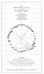
Cumbria and Westmorland Antiquarian and Archaeological Society. Swinside aka Sunkenkirk Stone Circle [Map]. This is a very good example of a circle built in close order; and it is probable that, when perfect, all the successive stones were nearly contiguous. The gateway points slightly down-hill. But few of the stones seem to have been removed — probably because plenty of material for walling and road-making could be collected from the neighboring hill-side. A rowan-tree has sprung up in a rift in stone No. 2, which has been rent asunder by its growth. The falling of all the stones (perhaps excepting one) inward, is a rather singular circumstance which can hardly be accounted-for by the usual natural causes.
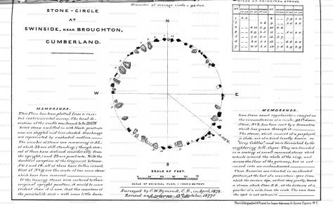
Cumbria and Westmorland Antiquarian and Archaeological Society. The following is a copy of Housman's account of the circle at Swinside, to be found on pp. 471-2 of his Topographical Description, before referred to. As an early authority, it may be well to quote it here, to supplement the series of extracts which were published in the fifth volume of these Transactions, pp. 47-50:-
About three miles north-west from Duddon-bridge, in a wild country, among dreary mountains, there is a druidical temple, called Sunken-kirk [Map], which consists of a circle of large stones standing erect in the ground, and pretty close together, some of which are more than eight feet above the surface, and eleven feet in circumference. The larger stones are 50 in number, with an infinite number of smaller ones scattered about their bases. The form is nearly a circle, being 87 feet by 84 in diameter. It is seated in the level part of a high but swampy meadow, and near a solitary farmhouse. At the entrance there are four large stones, two placed on each side, at the distance of six feet."
Thwaites. The druidical temple, at Swineside [Map], is thus described by Mr. Gough, in his additions to Camden1:- "It is nearly a circle of very large stones, pretty entire, only a few fallen upon sloping ground in a swampy meadow. No situation could be more agreeable to the druids than this; mountains almost encircle it, not a tree is to be seen in the neighbourhood, nor a house, except a shepherd's cot at the foot of a mountain, sur- rounded by a few barren pastures.
"At the entrance, there are four large stones, two placed on each side, at the distance of six feet The largest on the left side, is five feet six inches in height, and ten feet in circumference. Through this you enter into a circular area, 29 yards by 30. This entrance is nearly south-east On the north or right hand side, is a huge stone, of a conical formf in height nearly nbe feet Opposite the entrance is another large stone, which has once been erect, but is now fallen within the area; its length is eight feet To the left hand or south-west is one, in height seven feet, in circumference eleven feet nine inches. The altar probably stood in the middle, as there are some stones still to be seen, sunk deep in the earth. The circle is nearly complete, except on the western, some stones are wanting. The largest stones are about 31 or 32 in number. The outward part of the circle, upon the sloping ground, is surrounded with a buttress, or rude pavement of smaller stones, raised about half a yard from the surface of the earth.
The situation and aspect of the druidical temple, near Keswick, is in every respect similar to this, except the rectangular recess, formed by ten large stones, which is peculiar to that at Keswick; but upon the whole, I think a preference will be given to this at Swineshead, as the stones in general appear much larger, and the circle more entire.
"This monument of antiquity, when viewed within the circle, strikes you with astonishment, how the massy stones could be placed in such regular order, either by human strength or mechanical power."
The Rev. Jeremiah Gilpin, A.M. of Broughton in Fumess, was so much interested in these vene- rable remains of a remote and, comparatively speaking, unknown period, that he was at the expense of having a view of them engraved, which appeared in the Gentleman's Magazine, for the year 1785.
Note 1. Vol. ii. p. 432.