Europe, British Isles, South-West England, Wiltshire, Avebury Henge and Stones, West Kennet Avenue
West Kennet Avenue is in Avebury Henge and Stones [Map], Avebury Avenues.
Carbon Date. 3780BC. Early Neolithic Carbon Dates
Report: Charcoal, ref SQUARE 2, from posthole 1 in occupation area on West Kennet Avenue at Avebury, Wiltshire, England. Subm M Pitts 1987. Comment (subm): must be rejected. [Ed: NGR not given, estimated only.]
ID: 8811, C14 ID: HAR-9694 Date BP: 5780 +/- 80, Start Date BP: 5700, End BP: 5860
OS Letter: SU, OS East: 9, OS North: 69
Archaeologist Name: A Keiller (age 44) 1934
Reference Name: Radiocarbon, 34, 1992, 61-2; Proc Prehist Soc, 58, 1992, 203-12; Archaeologia, 84, 1935, 99-162; Smith I, 'Windmill Hill and Avebury' (Oxford, 1965)
Council for British Archaeology (2012) Archaeological Site Index to Radiocarbon Dates from Great Britain and Ireland [data-set]. York: Archaeology Data Service [distributor] https://doi.org/10.5284/1017767
Carbon Date. 3780BC. Early Neolithic Carbon Dates
Report: charcoal; from hole 1 in occupation area on West Kennet Avenue. Excavated by Keiller in 1934; cutting VII2R, layer 2 (Smith 1965).
ID: 15123, C14 ID: HAR 9694 Date BP: 5780 +/- 80, Start Date BP: 5860, End BP: 5700
Abstract: Avebury; 1984-85
Reference Name: Bayliss, A, Hedges, R, Otlet, R, Switsur, R, and Walker, J 2012 'Radiocarbon dates: from samples funded by English Heritage between 1981 and 1988', Swindon: English Heritage
Council for British Archaeology (2012) Archaeological Site Index to Radiocarbon Dates from Great Britain and Ireland [data-set]. York: Archaeology Data Service [distributor] https://doi.org/10.5284/1017767
Carbon Date. 2280BC. Early Bronze Age Carbon Dates
Report: antler; from pit 1 in the occupation area on West Kennet Avenue. Excavated by Keiller in 1934 (Smith 1965).
ID: 15121, C14 ID: HAR 10501 Date BP: 4280 +/- 100, Start Date BP: 4380, End BP: 4180
Abstract: Avebury; 1985-86
Reference Name: Bayliss, A, Hedges, R, Otlet, R, Switsur, R, and Walker, J 2012 'Radiocarbon dates: from samples funded by English Heritage between 1981 and 1988', Swindon: English Heritage
Council for British Archaeology (2012) Archaeological Site Index to Radiocarbon Dates from Great Britain and Ireland [data-set]. York: Archaeology Data Service [distributor] https://doi.org/10.5284/1017767
Carbon Date. 2280BC. Early Bronze Age Carbon Dates
Report: Antler, AML 831787, from pit in occupation area on West Kennet Avenue at Avebury, Wiltshire, England. Subm M Pitts ?. Comment (subm): agrees with finds from occupation, but does not date erection of stones in Avenue. [Ed: NGR not given, estimated only.]
ID: 8809, C14 ID: HAR-10501 Date BP: 4280 +/- 100, Start Date BP: 4180, End BP: 4380
OS Letter: SU, OS East: 9, OS North: 69
Archaeologist Name: A Keiller (age 44) 1934
Reference Name: Radiocarbon, 34, 1992, 61-2; Proc Prehist Soc, 58, 1992, 203-12; Archaeologia, 84, 1935, 99-162; Smith I, 'Windmill Hill and Avebury' (Oxford, 1965)
Council for British Archaeology (2012) Archaeological Site Index to Radiocarbon Dates from Great Britain and Ireland [data-set]. York: Archaeology Data Service [distributor] https://doi.org/10.5284/1017767
Carbon Date. 2260BC. Early Bronze Age Carbon Dates
Report: charcoal; from hole 4 in the occupation area on West Kennet Avenue. Excavated by Keiller in 1934 (Smith 1965).
ID: 15124, C14 ID: HAR 9695 Date BP: 4260 +/- 80, Start Date BP: 4340, End BP: 4180
Abstract: Avebury; 1984-85
Reference Name: Bayliss, A, Hedges, R, Otlet, R, Switsur, R, and Walker, J 2012 'Radiocarbon dates: from samples funded by English Heritage between 1981 and 1988', Swindon: English Heritage
Council for British Archaeology (2012) Archaeological Site Index to Radiocarbon Dates from Great Britain and Ireland [data-set]. York: Archaeology Data Service [distributor] https://doi.org/10.5284/1017767
Carbon Date. 2260BC. Early Bronze Age Carbon Dates
Report: Charcoal, ref SQUARE 3, from Hole 4 in the occupation area on the West Kennet Avenue, Avebury, Wiltshire, England. Subm M Pitts 1987. Comment (subm): agrees with finds from occupation, but does not date erection of stones in Avenue.
ID: 8802, C14 ID: HAR-9695 Date BP: 4260 +/- 80, Start Date BP: 4180, End BP: 4340
OS Letter: SU, OS East: 9, OS North: 69
Archaeologist Name: A Keiller (age 44) 1934
Reference Name: Radiocarbon, 34, 1992, 61-2; Proc Prehist Soc, 58, 1992, 203-12; Archaeologia, 84, 1935, 99-162; Smith I, 'Windmill Hill and Avebury' (Oxford, 1965)
Council for British Archaeology (2012) Archaeological Site Index to Radiocarbon Dates from Great Britain and Ireland [data-set]. York: Archaeology Data Service [distributor] https://doi.org/10.5284/1017767
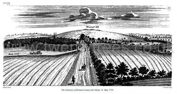
Avebury by William Stukeley. Table XVIII. The Entrance of Kennet avenue into Abury [Map] 14 May 1724.
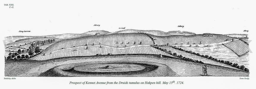
Avebury by William Stukeley. 15 May 1724. Table XXII. Prospect of Kennet Avenue from the Druids tumulus on Hakpen hill. May 15th 1724. [On the left West Kennet Long Barrow [Map], in the middle Silbury Hill [Map], Avebury very right]
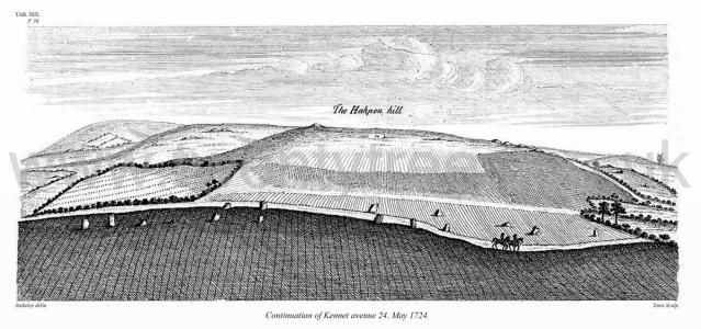
Avebury by William Stukeley. Table XIX. Continuation of Kennet avenue 24 May 1724.
Colt Hoare 1812. KENNET AVENUE. "The whole length of this avenue consists of a hundred stones on each side, reaching from the vallum of Abury town to the circular work on Overton hill. Measuring the breadth of it in several places, where I had the opportunity of two opposite stones being left, I found a difference, and the like by measuring the incervral of the stones side-ways; yet there was the same proportion observed between breadth and interval, which I found to be as two to three: so that here by Abury town, in that part which represented the belly of the snake, the breadth of the avenue was thirty-four cubits, ( fifty-six feet and a half,) and the intervals of the stones sideways, fifty cubits, (eighty-six feet, five inches and a half) the proportion of two to three, twice seventeen being thirty-four; thrice seventeen, fifty. These thirty-four cubits (or fifty-six feet and a half) take in the entire space of two intervals of the stones of the outer great circle of the Temple of Abury within the ditch, together with thc intermediate stone which is the entry of the avenue to the Temple. When we mount up Overton hill, the avenue grows much narrower; and this observation helped me in the discovery of the purport and design of the whole figure of the Snake, and in the nature of the scheme thereof."1
"When abode here for some time on purpose for several summers together, I was very careful in tracing it out, knew the distinct number of each stone remaining, and where every one stood that was wanting, which often surprised the country people, who remembered them left on the ground or standing, and told me who had carried them away.
Note 1. Two stones now only remain opposite to each other in the Kennet avenue, by which I am enabled to give the distance between them, which was fifty-one feet. The breadth lessens as it approaches towards the head of the Snake, and increases as it approaches towards tho body. The lateral distances between the stones of this avenue are more equal than I expected, being upon an average seventy-three feet asunder, the broad sides being placed facing the avenue. H.
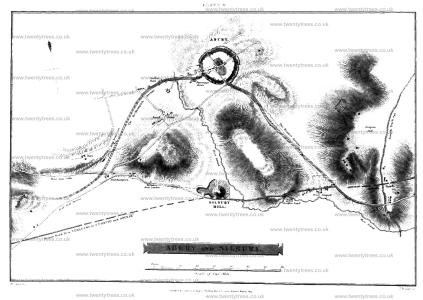
Colt Hoare 1812. On examining this ground plan, we perceive a degree of symmetry, of which, except upon paper, we could form no conception, nor for which could we give credit to the early Britons. We behold the grand circle placed in the centre of the picture, and the huge mount of Silbury in a line opposite to it1. Two avenues, like wings, expand themselves to the right and left, as if to protect the hallowed sanctuary, and the holy mount. The eastern avenue, terminates with a circular temple [Map], thus distinguishing it as a place of peculiar eminence. From the winding form of this work, Dr. Stukeley has very ingeniously developed the form of a serpent, and distinguished this temple as one of that class called by the ancients Dracontia.
This plan receives additional interest by comprehending same groups of barrows, which I investigated, the principal source of the river Kennet, a small portion of the British Track-way, passing from the district of South Wiltshire, throughout the whole extent of Berkshire2, and a large portion of the Roman road between Bath and Marlborough.
Note 1. Dr. Stukeley remarks that the meridian line passed through the centre of the Grand Circle, and of Silbury Hill; and on making our observations, and allowing for the variation of the compass, we find it still does the same.
Note 2. The course of this ridge-way has already been described, page 45. still does the same.
Wiltshire Archaeological Magazine 1857 V4 Pages 307-363. The Kennet Avenue
Of the Kennet avenue, the eastern part of which represented the neck of the serpent, and which narrowed as it mounted, Kennet Hill to join the head, Stukeley says, "Mr. Smith living here, informed me that when he was a schoolboy, the Kennet avenue was entire, from end to end." As however the stones composing it covered a few feet of ground which the Greens and Griffins coveted, a war of extermination was waged against them; and when the stubborn blocks refused to succumb to fire and the hammer, they were buried in pits dug about them; "Two of them lie six feet under ground in the premises of Mr. Butler of Kennet, and over another the Bath road passes."1 The work of destruction has been so successfully carried out that only 19 stones, or their stumps, are now visible between West Kennet and Abury; four in the bank on the left hand side of the road from Marlborough as it enters Kennet, and which can only be seen by going into the adjoining field;2 two on the Abury side of Kennet, between which the road passes; eleven in the field on the left of the road; one on the brow of the hill by the road side; and one close to the turnpike gate outside the vallam. Measuring the breadth of the avenue in several places, where Stukeley "had an opportunity of two opposite stones being left, he found a difference; and the like by measuring the interval of stones sideways; yet there was the same proportion preserved between breadth and interval, which he found to be as 2 to 3. So that by Abury town in a part that represented the belly of the snake, the breadth of the avenue was 34 cubits (564 feet) and the intervals of the stones sides 50 cubits (863 feet,) the proportion of 2 to 3.'
Note 1. The Rev. J. B. Deane's "Worship of the Serpent traced throughout the World," p. 381, 1833.
Note 2. These four stones lie about 30 paces apart. That these were the original, or nearly the original distances, seems confirmed by Stukeley's 20th plate.
Note 3. Stukeley, p. 29. In the Charter of Athelstane quoted hereafter, will be found the earliest notice (probably) of this avenue, or indeed of any part of Abury.
Wiltshire Archaeological Magazine 1878 V17 Pages 327-335. The Kennet Avenue and "Sanctuary [Map]."
The inaccuracies in Aubrey’s sketch (plate ii. fig 2), entitled by him "The whole view of Aubury with the Walkes and the lesser Temple appendant to it,’ are best explained by accepting it as a "draught of it donne by memorie only." of the avenue appears to have been interrupted; and this interruption, His more careful survey he says, "hindered me from measuring it,’ and the survey seems never to have been resumed. His sketch is probably too rectilinear, and inaccurate therefore as regards the angle which it makes at West Kennet, before ascending Overton Hill, to join the circles there, called the "Sanctuary." "From Kynet," he says, "it turnes with a right angle eastward crossing the river and ascends up the hill to another monument of the same kind." Aubrey, who tells us he " writt upon the spott from the monuments themselves," must here indeed have "writt,’’ as he says, " as he rode a gallop; "the statement that the avenue crossed the river being at variance with his own plan (perhaps we should read "crossed the road," instead of "crossed the river"). The angle must certainly have been very w from a right angle. The stones which formed it near the village West Kennet had many of them in Stukeley’s time been removed and destroyed, as he himself tells us (p. 30). Notwithstanding ese defects, Dr. Stukeley had clearly sufficient evidence for his statement that the avenue "makes a mighty curve to the left" (i.e., the east, p. 31). This, in his "Scenographic view" of the whole temple,is represented as a very gradual curve, which, if produced to an angle, would be a very obtuse one. Stukeley’s draught of this avenue from Abury to Kennet, in the sketch book before mentioned, is very like that given by Aubrey, and running in a straight line to " Kennett Town,’ would require as complete a right angle as Aubrey’s to connect the avenue with the circles on Overton Hill. Stukeley alludes to Aubrey’s description of this avenue, which had been printed in Gibson’s Camden, and says of it, "he [Aubrey] did not see that ’tis but one avenue from Aubury to Overton Hill, having no apprehension of the double curve it makes." It is, very possibly, a copy of Aubrey’s own sketch of this avenue, made by his friend, Edward Llwyd, to which Stukeley, at a subsequent page, refers, when he says, " he did not discern the curve of it," but "has drawn [it] as a straight line." An error, the reverse of that of Aubrey, is found in Crocker’s plan, in 1812, in which the bold curve of the avenue at Kennet is entirely overlooked, and its course represented as a very slight curve, entirely on the east side of the village, whereas it must have passed through its very centre. This is clear enough from Stukeley’s description, and is even now confirmed by the large stone in the garden opposite the brewery, which was buried there by Mr. Butler, who, with reason, believed it to have formed part of the avenue, and who pointed out the situation of a second stone in a hedge-bottom a little farther to the west. The existence of these stones we may conclude was not known to Sir Richard Hoare, or Mr. Crocker.1
Note 1. With reference to these Kennet stones, which would, in great measure, determine the character of the angular curve made at this part of the avenue, I find the following among my Abury memoranda, The first is a communication from Mr. W. Cunnington: "The late Mr. Butler, of Kennet, a good antiquary, and an early supporter of the ‘ Wiltshire Topographical Society,’ gave me, a few months before his death, in 1873, the following information relating to the Kennet Avenue. He remembered a stone which stood near Mr. Kemm’s house, at West Kennet. When the road was altered some years ago, as this stone was standing in the middle of the proposed route, it was thrown down, and buried under the road, where it, no doubt, still exists. Further on, where there are now two cottages, at the foot of Overton Hill, on the right-hand side of the road, stood two stones, which he remembered were broken up by order of the road-commissioners early in the present century. Mrs B. told me that while this work of destruction was going on, two gentlemen from London, in a post chaise, saw the men thus engaged. They drew up and expressed their disapproval in warm language; one of them winding up by telling the foreman that a man who would undertake such work, ought not to die in his bed. The man's name was Shipway, he lived at Avebury; and, added Mr. B., the saying of the gentleman was fulfilled, for the man hung himself." The following letter from Mr. Butler appears to have been addressed to Dr. Thurnam:—
Kennet Brewery, near Marlborough, Wilts',
January 21st, 1858.
Sir, I am sorry you did not send in your man Then you was here. Though I was very unwell, I was not so much but I could have seen you, and J could have explained what I knew of the stone (better) than I can on paper. I only know ot one stone now the Bath Road, and that lies a few feet on the Marlborough side of the cottage which is nearly opposite Mrs. Kemm's house. I do noi remember its being buried, but from what I have heard it must have been-about 1807-8, or 9. There vas a stone broke in the winter of 1824-5, on the north side of the road further on towards Marl. borough, and which there is no doubt was one of the avenue. It had fallen and was buried by the scraping of the road, and was broke to make the present foot-path, as partly buried in the bank on the south side of the road is some of the stones which is believed to be a part of the avenue. I know of no other stones round, except it is one I had buried in my garden, which from the sizes and situation, I believe must have been one of the avenue.
I am, Sir,
Your obedient Servant,
George Butler."
In a memorandum in Dr. Thurnam's handwriting, dated April 20th, 1860, I find as follows: Stone in Mr. Butler's garden buried seven feet deep, about two yards within door, and about thirty paces from edge of road opposite easternmost window of Mr. B.'s house. A second stone was discovered in burying a horse, three years ago, in a sort of paddock, close to garden to west. This shown by charcoal and ashes such as left by old-fashioned destruction of sarsens. The place of this about four times as far from road, and opposite to end of west wall of Mr. Butler's brewery and house. A third stone a little to north, north-west, in bank of hedge in same field (once line of Kennet and Abury road, until early in the century.) This looked for in bank of hedge, but not found. The sort of curve made by junction with two stones remaining of avenue clearly seen. A stone opposite to Mrs. Kemm's house in road below path and another nearer to cottage very near in Marlborough road, as before described,"
Wiltshire Archaeological Magazine 1907 V35 Pages 515-517. Avebury, Orientation of the Avenues. Sir Norman Lockyer, in Nature, Jan. 16tb, 1908, pp. 249—251.
dealing with the alignment of the Avebury Avenues [West Kennet Avenue and Beckhampton Avenue], and their significance, says " I have measured several avenues since ' Stonehenge' was published, and I have studied others of which the. orientation could be deteimined by the Ordnance Maps. Many of them have been found to have had the same astronomical use which had been suggested in those measured on Dartmoor." He then takes the course of the Beckhampton avenue as according to Stukeley passing by the south side of the churchyard, and finds that a line " joining the two large monoliths at the west end of the Beckhampton avenue and the Cove (in the centre of the northern circle) . . passes close to the stones indicated by Stukeley." He then gives Stukeley's desci'iption of this avenue : and continues " It will be seen that the May Year Avenue line is directed nearlj-, but not quite, to the centre of the northern circle, the Cove occupying the centre itself, so block- ing the view from the avenue or processional road to the S.W." He then deals with theKennetA venue, after quoting Stukeley's andLong's accounts of it : " As will be seen from the map [a photo from the 25in. ordnance survey], this avenue apparentlj' was connected with the southern circle as the Beckhampton one was with the northern one. If this were so, certainly the enormous bank, erected apparently for spectacular purposes, which is such a striking feature of Avebury, was not made until after the Kennet avenue had fallen out of any astronomical use . . This avenue seems to have struck another aligned from the circle on Overton Hill, which formerly M'as oriented to the May sunset or the November sunrise to judge from the positions of the stones given in Smith's map."
Keiller Collection Photos. 1908. West Kennet Avenue. Probably Florence Harriet Young (age 32).
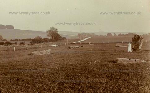
Wiltshire Archaeological Magazine 1913 V38 Pages 1-11. A Buried Stone in Kennet Avenue
A large sarsen, probably one of tbe stones of the Kennet avenue was recently (February, 1913) exposed in a trench cut for the purpose of laying down water pipes. The trench was cut from the top of the hill South of Avebury, sometimes called Windmill Hill, or Windmill Ball,1 across the Kennet-Avebury road, and therefore across the line of the Kennet avenue, to a pumping station in the valley south-east of Avebury vallum.2
Note 1. This hill should not be confused with the Windmill Hill north of Avebury. See Smith's Antiquities of North Wilts, p. 145, d.
Note 2. The pond dug a few years ago on the top of this hill is utilised as a reservoir to which the water is pumped. The barrow marked "d "on Smith's Map (Section XL, G. V.) must have been on the site of, or very near, this pond. No trace of the barrow can now be found.
Wiltshire Archaeological Magazine 1913 V38 Pages 1-11. The Kennet Avenue Stone
While the work of raising the big stone at Longstone Cove was in preparation, it was suggested that, while the necessary apparatus was on the ground, it would be a good opportunity to raise the stone in the Kennet avenue that fell cir. 1889 (?), and this course was ultimately decided upon at a committee meeting of the Society in July, 1912. This stone is the third from the Avebury end of the line of seven stones on the east side of the avenue, in the group of eleven stones lying west of the road between Avebury and Kennet and is opposite to the only one of the group which still remained standing. The ground has been under the plough within the last few years, and the cavity made by the fall of the stone had been filled up and levelled off. On re-excavating this it was found that the hole as originally made to receive the stone was not so well defined as in the. case of that at Longstone Cove, where it had been dug into the solid chalk, for the base of the Kennet stone stood on a bed of chalk rubble at a depth of only 16in. below the surface. It was felt that there could be no certainty that this rubble had not been disturbed, and in view of the possibility of an interment having been made under the stone, the digging.was continued down until the solid chalk was reached at a depth of 4ft. Gin. from the surface. The depth of the rubble over the chalk varies considerably even in a small area, but as this seemed a greater depth than is usual, a hole was dug some yards away from thestone to test it there, and the same conditions were found. The spot is at the bottom of the steepish hillside in the valley leading from Avebury to Kennet, a situation where, perhaps, a greater accumulation of debris might be expected than on more open or higher chalk lands.
Archaeologia Volume 84 1935 Section VI. The plan also includes the only remaining standing-stone of the Kennet Avenue close to Avebury, at a distance of 280 it. SSE. oi the nearest point of the Great Outer Circle, to which we must now turn.
Keiller Collection Photos. 1934. West Kennet Avenue during excavation.
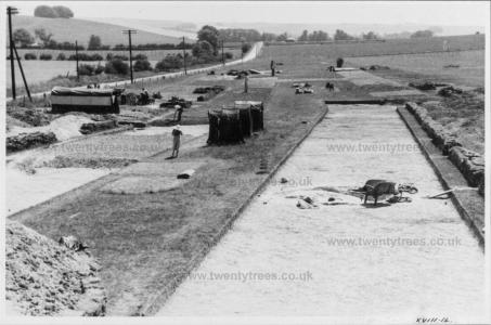
Keiller Collection Photos. 1934. West Kennet Avenue before excavation.
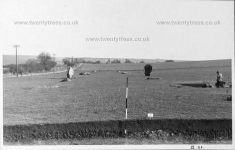
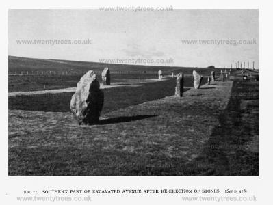
Antiquity 1936 Volume 10 Issue 40 Pages 417-427. Excavations in the West Kennet Avenue were begun in 1934 by The Morven Institute of Archaeological Research under the joint direction of the writers. The primary purpose of these excavations was to establish the exact course followed by the avenue, and furthermore, if possible, to arrive at a definite date and culture for the construction of the monument. The opportunity was taken by the excavators of re-erecting all fallen stones, and stones which, as will be later described, were found to have been buried (FIG. 11). The entire course of the northern third of the avenue had been exposed by the end of 1935. Prior to excavation the only visible signs existing, for even the approximate course of this part of the avenue, consisted of three standing stones and nine others which were lying prone; a tenth had fallen and had been re-erected in 1912, but in an incorrect position as well as upside down.2 The evidence on which the excavators relied was naturally the discovery of the stoneholes or sockets in which stones had stood. All except one of these were satisfactorily identified; in the case of this stonehole (no. 15)3 there is no reason to suppose that no stone stood between nos. 13 and 17, but it may be presumed that the stonehole was so shallow as not to penetrate the subsoil.
Note 2. Wilts. Arch. Mag., XXXVIII, 7.
Note 3. The numbering of stoneholes and stones used in this article is that adopted for convenience during the excavations and begins from the southern end of the excavated portion, the left-hand stone to an observer facing Avebury being no. I and the right-hand no. 2 and so on.
1935. Alexander Keiller's Plan Of The Restored Section Of The West Kennet Avenue. The stones are numbered as pairs a & b. Western stones (top) are b, Eastern stones (bottom) are a.

Keiller's Slides TR000009. General view of West Kennet Avenue towards the henge, with stone 37a [Map] in the foreground.
Europe, British Isles, South-West England, Wiltshire, Avebury Henge and Stones, West Kennet Avenue Stones 13 [Map]![]()
Keiller's Slides TR000010. General view of stones 13a and 13b [Map] in West Kennet Avenue, showing the west faces.
Europe, British Isles, South-West England, Wiltshire, Avebury Henge and Stones, West Kennet Avenue Stones 15 [Map]![]()
Keiller's Slides TR000005. General view of stones 15a and 15b [Map] in West Kennet Avenue, showing the west faces.
Europe, British Isles, South-West England, Wiltshire, Avebury Henge and Stones, West Kennet Avenue Stones 25 [Map]![]()
Keiller's Slides TR000006. General view of stone 25b [Map] in West Kennet Avenue, showing the west face.
Europe, British Isles, South-West England, Wiltshire, Avebury Henge and Stones, West Kennet Avenue Stones 26 [Map]![]()
Keiller's Slides TR000004. General view of stone 26a [Map] in West Kennet Avenue, showing the west face.
Keiller's Slides TR000008. General view of stones 26a and 26b [Map] in West Kennet Avenue, showing the west faces.
Europe, British Isles, South-West England, Wiltshire, Avebury Henge and Stones, West Kennet Avenue Stones 37 [Map]![]()
Keiller's Slides TR000009. General view of West Kennet Avenue towards the henge, with stone 37a [Map] in the foreground.