Europe, British Isles, North-Central England, Derbyshire, High Peak, Buxton [Map]
Buxton, Derbyshire is in High Peak, Derbyshire.
Archaeologia Volume 32 Section X. But her health gave way, and by the mediation of the French Ambassador she was permitted to visit the baths at Buxton [Map], during several summers. But, when there, all other persons were ordered to depart. Her first visit was in August, 1573, and before she returned to the castle she was allowed to visit Chatsworth [Map]. Her next visit to Buxton [Map] was in May and June, 1577. In the summer of 1578, she was again at Chatsworth [Map], and the visit was repeated in the summer of 1579, when she was also at Buxton [Map]. In 1580, the earl (age 45) applied for leave to visit Chatsworth [Map] with his charge, and was refused; but in the July of that year the Queen (age 30) was at Buxton [Map]. Again, in July, 1581, we find her at Chatsworth [Map]; in June, 1582, at Buxton [Map], where also she appears to have been in July, 1584.

In 1799 Thomas Orlando Sheldon Jewitt was born to Arthur Jewitt (age 26) and Martha Sheldon of Crooke's Moor in Sheffield at Buxton, Derbyshire [Map].
On 21 Jun 1806, whilst visiting Buxton, Derbyshire [Map], Wilfrid Lawson 10th Baronet (age 42) developed an illness and died unexpectedly. Baronet Lawson of Isel Hall in Cumbria extinct. His estates, including Brayton Hall, Aspatria, were inherited by a Thomas Wybergh aka Lawson (age 12), nephew of his wife Anne Hartley (age 42). He died six years later and the estates were inherited by his brother Wilfrid Wybergh aka Lawson 1st Baronet (age 10) who was subsequently created Baronet Lawson.
On 24 Sep 1878 George Colthurst 5th Baronet (age 54) died at Buxton, Derbyshire [Map] where he had gone to recover from gout. His son George St John Colthurst 6th Baronet (age 28) succeeded 6th Baronet Colthurst of Ardum in County Cork.
On 02 Jun 1965 a cricket match in Buxton, Derbyshire [Map] between Derbyshire and Lancashire, had to be postponed due to a freak snow storm.
The Derbyshire River Wye rises at Axe Edge Moor [Map] after which it travels broadly south-west through Buxton, Derbyshire [Map], Millers Dale [Map], Cressbrook, Derbyshire [Map], Ashford-in-the-Water, Derbyshire [Map], Bakewell, Derbyshire [Map] and Haddon Hall [Map] to Rowsley [Map] where it joins the River Derwent.
Europe, British Isles, North-Central England, Derbyshire, High Peak, Buxton, Anthony Hill Barrow [Map]
Anthony Hill Barrow is also in Peak District Bronze Age Barrows.
Stakor Hill. In the afternoon, we made four trenches in another barrow, situated on a neighbouring eminence, called Anthony Hill [Map]. It measures about fourteen yards across, and is not more than a foot in height, having been removed to within a few inches of the natural soil. Many fragments of human bone, and a boar's tusk, were found just under the turf, but no depression in the natural level being observed, it became evident that all the interments were destroyed from not having been buried deeper.
Europe, British Isles, North-Central England, Derbyshire, High Peak, Buxton, Axe Edge Moor [Map]
The Derbyshire River Wye rises at Axe Edge Moor [Map] after which it travels broadly south-west through Buxton, Derbyshire [Map], Millers Dale [Map], Cressbrook, Derbyshire [Map], Ashford-in-the-Water, Derbyshire [Map], Bakewell, Derbyshire [Map] and Haddon Hall [Map] to Rowsley [Map] where it joins the River Derwent.
The River Dove rises on Axe Edge Moor [Map] after which it travels broadly south past Longnor, Saffordshire [Map], Pilsbury [Map], Hartington [Map], Milldale, Derbyshire [Map], Thorpe, Derbyshire [Map], just before whic it is joined by the River Manifold, Mapleton, Derbyshire [Map], Mayfield, Staffordshire [Map], Norbury, Derbyshire [Map], Rocester, Staffordshire [Map], Sudbury Hall [Map] and Tutbury Castle, Staffordshire [Map] before joining the River Trent at Newton Solney [Map].
The River Manifold rises on Axe Edge Moor [Map] after which it travels broadly south past Longnor, Saffordshire [Map], Hulme End [Map], Ecton, Staffordshire [Map], Thor's Cave [Map], Beeston Tor, Staffordshire [Map] and Ilam, Staffordshire [Map] at which it joins the River Dove.
Europe, British Isles, North-Central England, Derbyshire, High Peak, Buxton, Brierlow
Europe, British Isles, North-Central England, Derbyshire, High Peak, Buxton, Brierlow, Brier Low Barrow [Map]
Brier Low Barrow is also in Peak District Bronze Age Barrows.
Thomas Bateman 1845. On the 12th of May, 1845, was opened a very large cairn, or stony barrow, called Brier Lowe [Map], near Buxton; it was about six feet in central elevation, and about twenty yards in diameter. On approaching the centre, upon the level of the natural surface, it was found to be covered with rats' bones, amongst which were some small pieces of an urn, and some burnt human bones, which had doubtless been disturbed upon the occasion of the interment of a body, which was discovered in the middle of the barrow. This skeleton was laid upon some flat limestones, placed on the natural ground, with its head towards the south, and its knees contracted; it was very large and strong, and was accompanied by a bronze dagger, in excellent preservation, with three rivets remaining which had attached the handle: this fine instrument lay close to the middle of the left upper arm, and is the first of the kind ever found in Derbyshire. The skeleton was surrounded with a multitude of rats' bones, the remains of animals which had in former times feasted upon the carcass of the defunct warrior, which fact was satisfactorily proved by the gnawed appearance of the various bones, and from the circumstance of several of the smaller ones having been dragged under the large flat stones upon which the body lay, and which could not by any other means have got into that situation. This barrow is extremely interesting, as having produced conclusive evidence regarding the "quæstio vexata" of the cause of the perpetual occurrence of rats' bones in barrows in various places, which are the remains of generations of those unpleasant quadrupeds which have burrowed into the tumuli, in all probability to devour the bodies therein interred.
Europe, British Isles, North-Central England, Derbyshire, High Peak, Buxton Cemetery
On 22 Jan 1915 Micah Salt (age 68) died. He was buried at Buxton Cemetery. His gravestone is a replica of the Anglo-Saxon cross in Eyam Cemetery.
Europe, British Isles, North-Central England, Derbyshire, High Peak, Buxton, Cow Low Barrow [Map]
Cow Low Barrow is also in Peak District Bronze Age Barrows.
Arthur Jewitt 1811. From hence looking across the river, several other lowes are visible, among the most conspicuous of which, are Cowlow [Map], which gives name to a small village, and Woolowe and Lowefoot, each of which gives name to a pleasant farm.
Whether the two last have or have not been opened, is not at present but the former, that at Cowlow, was examined a few years ago, and a number of bones of an uncommon size were found therein, of which two or three very large jaw-bones, apparently sound and good, with all the teeth entire, are preserved by a gentleman in Buxton. Some kind of ancient implements were found at the same time, which are said to be now in the possession of two maiden ladies at Great Rocks.
It is worthy of remark that in opening the above lowe, a large quantity of teeth and jaws were found in one part of it, which appear to have belonged to rats, or to some other animal of similar habits and correspondent size ; no other bones of these animals, except those appertaining to the head, could be found. What animals they were, or for what purpose their heads were here deposited in heaps, is a mystery which at present it will be diffcult to explain ; it may perhaps owe its origin to some religious rite.
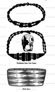
Thomas Bateman 1846. On the 29th of August 1846. The barrow at Cow Lowe [Map], near Buxton, was opened; although a little disturbed on the surface by the operations of stone-getters, the interments were quite intact. The number and importance of these deposits render needful a minute description of most of them, and a chronological arrangement will make each particular much more intelligible; by the latter system, we commence with the presumed primary interment, then tracing each succeeding one, in the order in which it was inhumed, instead of relating the particulars of each, in the rotation in which they were brought to light by the spade. Upon the floor of the barrow, which slightly exceeded the depth of four feet from the summit, was laid apparently the primitive interment, covered over with a large flat stone, but not inclosed in a cist; it was the body of a person of small stature, probably a female, with the knees contracted; it altogether rested upon a layer of calcined human bones, amongst which was found a bone pin, which had been perforated at the thicker end, but now broken, and part of a dog's head, also several horses' teeth; a few inches higher up, the whole of the centre of the tumulus was covered with human bones, unaccompanied by anything worthy of notice, if we except a few pieces of an urn, coarse, both in material and workmanship. The number of jaw-bones belonging to different skeletons in this part of the barrow was five, though it is probable that a greater number of individuals were here interred. About a foot higher than these, and slightly out of the centre of the barrow, was a small cist, made of stones set edgeways, which contained the bones of a female in the usual contracted position, with which were two sets of Kimmeridge coal beads (one hundred and seventeen in number), of very neat workmanship; the central ornaments are in this case made of the same material as the beads, though it will be remembered that, in the similar ornament found at Wind Lowe [Map], the central plates were of bone or ivory; a faintly marked diamond pattern is discernible upon the plates of shale; with these lay a fine instrument of calcined flint, of the circular-ended form; a few of the beads lay on the outside of the cist, where was part of the skeleton of a child, to whom possibly one set of beads might belong, or, what is more probable, that they were disturbed at the time of the construction of the hexagonal cell, which was placed partly upon the cist pertaining to the lady, at a slightly higher level; in it were deposited two skeletons, one above the other, much crushed up in order to accommodate them to the confined limits of the cell; with the lower one was a neatly ornamented urn of unbaked clay, much decayed and broken. The latest and most interesting interment, which may be attributed to the Romano-British period, or perhaps by some antiquaries to the early Saxon era, lay in the centre of the harrow, and about midway between the surface of the natural ground and the top of the former; the bones were mostly decayed, so much indeed, as to leave no trace except the teeth, and a small portion of the cranium; near which, probably about the neck, were two pins of gold, connected by a chain of the same, of remarkably neat design and execution; the heads of the pins contain a setting of many coloured glass, platted upon a chequered gold foil; close to them, and apparently having slipped off the chain, by a large bead of blue glass. The earth for a few feet from this place appeared to have been tempered with water, or puddled, at the time of the funeral, which gave it a very solid and undisturbed appearance; this, coupled with the absence of bones, makes it difficult to decide near what part of body the following articles were originally placed; they were about eighteen inches distant from the pins, which were certainly close to the head. These articles had been inclosed in a wooden box, made of ash plank half an inch in thickness, which was wrapped in a woollen cloth, the warp of which is perfectly visible; the hinges of this casket (two in number) are of brass, and were fastened with brass pins, which were clenched upon a piece of stout leather in the inside of the box; it was fastened by a brass hasp of similar type to the hinges, which received a small staple, to which was hung an iron padlock; it contained a small vessel of thick green glass, an ivory comb much decayed, some instruments of iron, a piece of perforated ivory, apparently the end of some utensil, which was encircled by a brass hoop at the time of its discovery, but which fell to dust on exposure, and a neck decoration of various pensile ornaments, eleven in number; the centre one is of blue porcelain or glass, with three serpents in white; it is retained in a setting of silver, with vandyked edges, on either side of this is a spiral wire bead of electrum, whilst the suit is made up of small circular pendants of silver, extremely thin, each having a level back and a convex front, and each stamped out of a separate piece; of these the number is eight, and with the exception of one, which has a beaded circle running round it, are all struck from the same die, a small flaw being visible on each; the box also contained a dog's or fox's tooth; and a short distance above the body, in the same tempered earth, lay a portion of the horn of the red deer. In various parts of the tumulus, but not in situations where they could be allotted with certainty to any of the interments, were found a scattered deposit of burnt bones, a bead of Kimmeridge coal, of more globular form than the others, much worn, a neat pin of bone, a pointed instrument of the same, apparently a lance-head, and the usual chippings of flint, and rats' bones.
Note. Necklace, possibly, from Cow Low on display at Weston Park Museum, Sheffield.


Europe, British Isles, North-Central England, Derbyshire, High Peak, Buxton, Dow Low Barrow [Map]
Dow Low Barrow is also in Peak District Bronze Age Barrows.
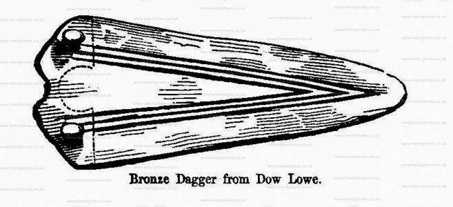
Thomas Bateman 1846. On the 5th of September, 1846, was examined the lower part of a large barrow (called Dowe Lowe) [Note. Dow Low Barrow [Map]] near Church Sterndale; the upper part of which had been some time removed, on which occasion an urn and other antiquities were found; fortunately the primary interment was left untouched; though the remnants of later interments deposited on a higher level, consisting of sundry pieces of bone, burnt and unburnt, fragments of urns, and a small piece of thin cylindrical brass, testified to the havock that had been made. The most remote interment consisted of two much decayed skeletons, lying near each other upon the floor of the barrow, about two yards from the centre; one was accompanied by a fluted brass dagger, placed near the upper bone of the arm, and an amulet or ornament of iron ore, with a large flint instrument, which had seen a good deal of service, lying near the pelvis. A few chippings of flint and calcined ];|Luman bones were distributed near the two skeletons.
Europe, British Isles, North-Central England, Derbyshire, High Peak, Buxton, Fairfield
Europe, British Isles, North-Central England, Derbyshire, High Peak, Buxton, Fairfield Low [Map]
Fairfield Low is also in Peak District Bronze Age Barrows.
Proceedings of the Society of Antiquaries V17 1899 Feb 02: Fairfield. On the 29th of October, 1895, Messrs. Salt opened a barrow, known as The Low [Fairfield Low [Map]], on a hill about 3 mile east of Fairfield and 14 mile east-north-east of Buxton. It is circular, about 60 feet in diameter and 4 feet in height, and is composed of gravel and soil. A large portion extending from the south-east side to almost the centre has long been removed in the process of quarrying the limestone rock below. Messrs. Salt began their work by cutting a trench from the abrupt edge left by the quarrymen to and beyond the centre. At or a trifle west of the centre they found the scattered remains of a skeleton in a very decayed condition, lying on the natural rock, which was here about 30 inches below the summit. With these remains were a multitude of rats' bones, several teeth of probably the stag, charred bones, and charcoal.
On the following day the trench was continued further north. At about 38 feet beyond the above interment were found (1st), at a depth of only 6 inches below the turf, part of a stag's horn, several shapeless bits of iron, and a fragment of red wheel-made pottery ; and (2nd), 18 inches deeper, a piece of red ochre, a flint flake, a fragment of coarse pottery, and several pieces of sandstone which had been in the fire. It is evident that all this portion of the barrow had been disturbed on some former occasion. The higher objects probably related to a late interment.
On January 31st following Messrs. Salt resumed their diggings, and soon found an undisturbed interment some distance east of the centre. It was an unburnt skeleton in good preservation, lying on its left side in the usual flexed attitude, with the head towards the south-east. It rested upon the natural rock at a depth of about 2 feet from the summit of the barrow, and it had no further protection than that afforded by several large stones at the back. In the immediate vicinity were a few chippings of flint, coal, fragments of burnt bone (presumably animals'), and two indeterminate pieces of iron. These fragments of iron were about 7s inch in thickness, and on one side could be plainly seen under a magnifying-glass some hairy substance adhering to the rust.
Europe, British Isles, North-Central England, Derbyshire, High Peak, Buxton, Fairfield, New High Street
Europe, British Isles, North-Central England, Derbyshire, High Peak, Buxton, Fairfield, 34 New High Street [Map]
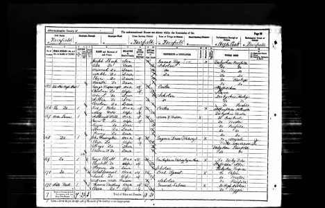
1891. 1891 Census Derbyshire Fairfield Page 22. 34 New High Street [Map].
George Henry Moorcroft (age 34). Head. 35. Carter. His name is given as George Havercroft?
Caroline Wood. Wife. 35.
Ada Louise Moorcroft (age 7). Daughter. 6. Scholar.
Arthur Moorcroft (age 4). Son. 4.
Caroline Moorcroft (age 1). Daughter. 1.
Europe, British Isles, North-Central England, Derbyshire, High Peak, Buxton, Fox Low Barrow [Map]
Fox Low Barrow is also in Peak District Bronze Age Barrows.
Hasling Houses. In the afternoon we examined the remains on Foxlow Hill [Map], near Buxton, where, in addition to some inconsiderable earthworks, there is the base of a large tumulus, the upper part of which had been removed to within a few inches of the rock. We found many traces of its former contents in the shape of human teeth and rats' bones, but all in the utmost confusion.
Europe, British Isles, North-Central England, Derbyshire, High Peak, Buxton, Gospel Hillock Barrow [Map]
Gospel Hillock Barrow is also in Peak District Bronze Age Barrows.
Gospel Hillock Barrow [Map]. Note the location of this barrow is uncertain.
Brushfield. On the same afternoon, we examined a mutilated barrow [Brushfield Barrow, location unknown] nearer Brushfield, called the "Gospel Hillock [Map]," perhaps from the first Christian Missionary having taken his stand thereon while exhorting the Saxons to forsake the worship of Woden and Thor; and we were much disappointed by finding nothing more than a few calcined bones and a fragment of pottery.
Frederick Lukis 1865. When we were about quitting Buxton, I was beginning to make a host of friends amongst the farmers and labourers, and from them obtained lots of information; this led me in my rambles over the spot where I was informed that two stone knives had been picked up (one of which was sent to London, and the other given to Mr. Bateman). I was climbing hill after hill without any positive certainty of meeting with anything of interest, when suddenly I saw, whilst crossing a wheat field, unmistakable signs of a Barrow [Map] [Gospel Hillock Barrow [Map]]. I called on the farmer, Mr. Charles Holmes, and on pointing to the heap of stones he at once exclaimed, 'Oh, sir, I wish they were out of that, for when ploughing that field we are sadly plagued by them.' I then asked to be allowed to make a small hole with a spade in the mound; this, he said, he could not grant, but added that if I were to call on the Rev. Mr. Pickford, the owner of the property, he doubtless would grant me permission to do so. After a walk to the house, and explaining the object of my visit, Mr. Pickford very kindly gave me leave on condition of levelling the ground again.
The next day we repaired to the place, and shortly after we were met by Miss Pickford, his sister, who most obligingly gave us the history of the mound in question. She narrated as follows 'The place was called from time immemorial "The Gospel Hillock;" the mound was held in considerable estimation and reverence, as its name imports, for here, in perilous times, people repaired for religious purposes, and holy persons preached and read the scriptures, whence it had obtained the name by which it was known.' We of course assented with her on its sacred character, and we thanked her for the valuable information we had obtained, and after her departure we commenced our operations with spade and pick, not doubting that ere long by these means the exact nature of 'Gospel Hillock' would tell a different tale as to its origin and purpose.
We commenced digging over that part marked a on the plan, and after proceeding with the usual caution always necessary in working on a low barrow, our spade soon produced the signs of interment - a few human bones were perceptible, which doubtless belonged to some skeleton not far distant. In a short time at the depth of a foot a skeleton was discovered, lying partly on its back with its legs evidently doubled up. We were the more surprised at finding this subject lying upon a flat surface or level of a stone, apparently of large dimensions. The very solid floor on which this individual lay induced us to extend out search, in order to determine its extent; in doing this we discovered several conical studs of polished kimmeridge coal, drilled with two connecting holes for being strung or fastened in the usual method of that period. The skull was evidently towards the east, and the cervical vertebræ, ribs, and bones of the arms, mixed up with the legs and the fingerbones, indicating that the body had not been stretched out, but rather in a doubled up position.
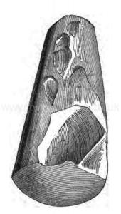
In proceeding to remove the earth in a westerly direction, I suddenly touched the skull of another individual lying in nearly the same position, and ex tended towards the western part of the large stone. Whilst cautiously clearing the earth away from the head, I fortunately perceived the keen edge of a flint celt, at E, (shown on the accompanying engraving), which lay on the stone and near the south side of the shoulder of B. I could scarcely express to my companions the delight I then felt, and as neither of them were acquainted with the nature of a celt, they were the more astonished at the cause of my excitement. Before removing the instrument I endeavoured to explain to them what their uses were, among all nations ancient and modern, and tried to answer a hundred questions which the subject gave rise to. After a very learned lecture on the celt, I gently extracted the object of my joy.
This little incident caused some delay in our operations, and after having exposed the second skeleton, we cleared the edge of the stone at c, and there found a third individual lying in the trench near it, and partly touching the large stone, which we now found measured 7 ft. 8 in. in diameter by 7 ft. 3 in. wide. Fragments of bones, teeth, and a few flint chippings were found also.
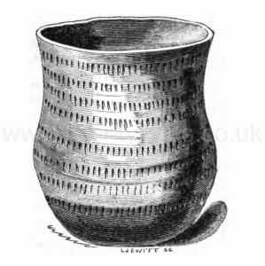
Note A. D, the pick-axe struck upon a largish stone, and in pursuing our work in that direction, we came upon a perfect little chamber without any covering stone, and on working down to the same level as our trough we came upon a pavement of flattish stones, on which were laid two skeletons; the western limit being closed up by stones and dry walling. Flint flakes were more numerous here, and against the northern props there was a neat urn, or drinking vessel, of reddish clay (but in the interior of a dark colour). On the external surface were eight circular rows of vertical indents, somewhat rudely engraved. The height was about seven inches, and it was not inelegant in its out line. This urn is here engraved.
After completing the excavation round the central stone we left off our work, intending on the morrow, if possible, to raise the flat suspicious base on which the skeletons reposed, and ascertain if it might not prove a covering to some more interesting deposit. The weather, however, was too wet and stormy for our work on that day.
On the following morning we repaired to the spot with that intention, but on arriving there found that the whole had been recovered and filled, by order of Mr. Pickford - that gentleman having unfortunately concluded that we were not to return to "Gospel Hillock" and restore it to its former outline as we had promised to do.
In forwarding these few notes and observations, I beg to say that they were written by Captain Lukis for insertion in my own collectanea, but if you consider them worthy of a place in the "Reliquary," it will afford him some pleasure to know that his visit to Derbyshire was not in vain.
The Grange, Guernsey.
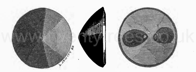
Proceedings of the Society of Antiquaries V17 1899 Feb 02: Gospel Hillock. About half a mile south-west of the village of King's Sterndale, a village 2½ miles east-south-east of Buxton, are two barrows about 140 yards apart known as 'Gospel Hillocks.' [Gospel Hillock Barrow [Map] and High Low Barrow [Map]] They are upon the slopes of High Cliff, a knoll on the high ground immediately south of the river Wye, and they have an elevation of between 1,000 and 1,100 feet above the sea. They are both marked on the 6 inches to 1 mile Ordnance Survey (1883). The largest, the one to the south-west [Map], is circular, and is almost demolished; the other, that to the north-east [Map], is oval, 30 feet by 21 feet and about 4 feet high, and it also has suffered somewhat, a portion of its summit having been removed many years ago to supply materials for repairing the neighbouring roads. This, the oval barrow, Messrs. Salt explored on 7th January, 1896.
Europe, British Isles, North-Central England, Derbyshire, High Peak, Buxton, Grin Low Barrow [Map]
Grin Low Barrow is also in Peak District Bronze Age Barrows.
Proceedings of the Society of Antiquaries V15 1895. In its present condition it [Grin Low Barrow [Map]] is a circular mound of about 60 feet in diameter, with an irregular convex top. Messrs. Salt commenced digging on April 25th, 1894, and soon found, as occasionally has been observed before in this district, that a natural elevation of the carboniferous limestone rock had been utilized. The artificial portion of the barrow consisted originally of stone only, but with the lapse of time the interstices had become filled up with earth by natural causes. Instead of being simply thrown together the larger stones exhibited here and there a definite arrangement, being placed on end and leaning towards the centre of the mound, a mode of construction by no means uncommon in the Peak barrows. The accompanying section, taken from a drawing by Mr. William Salt, will make the construction quite clear.
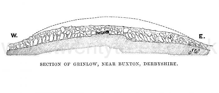
Ancient Remains near Buxton: Barrows: Grin Low. The suffix low (A.S. hlæw, a small hill, heap, or mound), I need hardly say, is very common in this part of the country, and should always be understood as indicating a barrow, whether any traces remain or not; in fact, it is still used as a common name for such burial places. In a great number of instances the mound has so far disappeared, that all memory of it has vanished and its name has been transferred to the site: this is the case with Grinlow [Map]. The name is now applied to a hill of irregular shape, about three-quarters of a mile south-west of Buxton, and with an altitude of about 1440 feet above the sea level. The barrow upon its summit, however, has by no means disappeared ; but its nature was not suspected from the circum- stance that it has served as the foundation of a conspicuous castellated structure known as 'Solomon's Temple.' This 'temple' was an ornamental structure, built one severe winter about sixty years ago to afford occupation to the unemployed of Buxton. Being constructed of unmortared rubble, it gradually succumbed to the wind and became a mere heap of stones, which served as a convenient quarry for materials for the stone fences of the neighbourhood. When, several years ago, all remains of the 'temple' had gone, the contour of the more solid barrow was rendered visible.
Europe, British Isles, North-Central England, Derbyshire, High Peak, Buxton, Hasling Houses Barrow [Map]
Hasling Houses Barrow is also in Prehistoric Peak Distrct Roman and Saxon Barrows.
Hasling Houses. On the 3rd of June, we opened a barrow at Hasling Houses [Map], near Buxton, measuring about twelve yards across and three feet in height, chiefly composed of tempered earth, except in the centre, where were a good many stones, covering a grave cut from east to west, about eighteen inches deep. Within it lay at length the skeleton of a powerful man of middle age, with the head to the west, who had been buried either within a coffin, or upon a thick plank with another above him, in order to keep off the pressure of the stones. In the earth, about a foot from the skull, we, found a rude instrument of flint, probably unconnected with the interment, and brought with earth from the neighbouring field as material for the mound. The femur measures 19½ inches; and both bones of the left leg had been fractured just below the knee, and strongly re-united by the formation of osseous substance many years before death. The body was most probably that of a Saxon.
Europe, British Isles, North-Central England, Derbyshire, High Peak, Buxton, High Low Barrow [Map]
High Low Barrow is also in Peak District Bronze Age Barrows.
Ten Years' Digging 1853 Hob Hurst's House. On the 22nd of September, we opened a barrow near King Sterndale, called High Low [Map], which being situated in a rough plantation, was incapable of measurement; it did not appear, however, to have been very large even at first, and had evidently been reduced in size since. We excavated a good deal of the centre, which we found about three feet higher than the natural surface, upon which was a considerable quantity of charcoal, but found that the whole had been turned over and plundered, so that nothing but fragments were seen. From them it was clear that two interments had taken place in the mound, the traces of the most ancient being manifest in part of a large coarse urn, a calcined flint, and probably the charcoal; those of the more recent were the bones of an adult skeleton, which had been accompanied by a drinking-cup, and many broken bones of animals, including stags' horns, some of the latter having been tooled or sawed. Bones of the water rat were plentifully distributed amongst the stones in the more open part of the tumulus.
Another mound, in a field close by, had been so thoroughly destroyed that we did not think it worth the trouble of examination.
Proceedings of the Society of Antiquaries V17 1899 Feb 02: Gospel Hillock. About half a mile south-west of the village of King's Sterndale, a village 2½ miles east-south-east of Buxton, are two barrows about 140 yards apart known as 'Gospel Hillocks.' [Gospel Hillock Barrow [Map] and High Low Barrow [Map]] They are upon the slopes of High Cliff, a knoll on the high ground immediately south of the river Wye, and they have an elevation of between 1,000 and 1,100 feet above the sea. They are both marked on the 6 inches to 1 mile Ordnance Survey (1883). The largest, the one to the south-west [Map], is circular, and is almost demolished; the other, that to the north-east [Map], is oval, 30 feet by 21 feet and about 4 feet high, and it also has suffered somewhat, a portion of its summit having been removed many years ago to supply materials for repairing the neighbouring roads. This, the oval barrow, Messrs. Salt explored on 7th January, 1896.
Europe, British Isles, North-Central England, Derbyshire, High Peak, Buxton, Hill Head Barrow [Map]
Hill Head Barrow is also in Peak District Bronze Age Barrows.
Hill Head. On the 5th of June, we opened a barrow [Hill Head Barrow [Map]] on the Hill Head, an eminence in the neighbourhood of the last. The mound is about twelve yards across, and presents the appearance of having been much reduced, the height being nowhere more than eighteen inches. The centre had been disturbed with the effect of displacing the skeletons of three or four persons and some calcined bones; the earth around did not appear to have been moved, as masses of rats' bones occupied their original level. Notwithstanding the unfavourable condition of the barrow, we collected 81 jet ornaments, composing a handsome necklace that had accompanied one of the skeletons, they comprise 53 cylindrical, and 11 flat beads, 12 conical studs, and five out of the six dividing plates requisite to form the decoration: the plates are plain, and the centre pair are perforated for eight beads to go between. It is likely that many more of the very small flat beads would have been found if the tumulus had not been before disturbed; those that were found being collected with much trouble from an area of many feet, instead of lying near the head of their owner.
Proceedings of the Society of Antiquaries V17 1899 Feb 02: Hill Head. In September, 1897, and the following February Messrs. Salt examined the remains of a small barrow on the north-east foot of Hill-Head [Hill Head Barrow [Map]], a hill 2½ miles south-east of Buxton. It is oval, about 25 feet by 15 feet, nowhere exceeding 18 inches in height, and appears to have consisted of earth and stones. The results of the excavations were very meagre, consisting of a few scattered burnt bones and one flint flake ; and I only mention the circumstance because the existence of this barrow had not been previously noted.
Europe, British Isles, North-Central England, Derbyshire, High Peak, Buxton, Hitter Hill Barrow [Map]
Hitter Hill Barrow is also in Peak District Bronze Age Barrows.
Llewellynn Jewitt 1870. Along with it were found a bronze dagger, a barbed arrow-head of flint, a beautiful drinking cup and other objects. This example is from Roundway Hill, in North Wiltshire.1 Another excellent example, from Hitter Hill [Map], Derbyshire, is given in the next engraving (fig. 9), which shows successive interments, each being on the left side, in the usual contracted position.
Of this barrow, the opening of which presented peculiarly interesting features, a tolerably detailed account will be advisable. It was opened by myself and Mr. Lucas in 1862. The mound, which was about twenty-two feet in diameter, was composed of rough stone and earth intermixed. It was only about three feet in height, its centre being somewhat sunk. The first opening was made at the part marked A on the accompanying ground-plan (fig. 10), where, from the outside, we cut a trench, four feet in width, in a north-easterly direction, towards the centre of the barrow, and soon came upon an interment of burnt and unburnt human bones. Along with these were an immense quantity of rats' bones2 and snail-shells. After proceeding to a distance of seven feet, we came upon the side, or what may almost be called the entrance, of a cist formed partly of the natural rock, and partly of stones set up edgewise. The dimensions of this cist were about forty inches by twenty-six inches, and it was two feet in depth, the floor being three feet six inches below the surface. The cist was formed between two portions of natural rock, and protected at its entrance by a large flat stone set up edgwise, and other stones filled up the interstices at the sides. It was also covered with a large flat stone. On clearing away the surrounding earth, after removing the covering stone, we were rewarded by finding that the cist contained the fragmentary remains of a young person, which had lain on its right side, in the usual position, with the knees drawn up.
Note 1. See Crania Britannica, one of the most valuable ethnological works ever issued.
Note 2. It will be well to bear in mind that when "rats' bones" are mentioned, it must be understood that they are the bones, not of the common rat, but of the water-vole or water-rat. They are very abundant in Derbyshire barrows, and, indeed, are so frequently found in them, that their presence in a mound is considered to be a certain indication of the presence of human remains. "The barrows of Derbyshire, a hilly, almost mountainous, county, abounding with beautiful brooks and rills, inhabited by the water-vole, were made use of for its hybernacula, or winter retreats, into which it stored its provisions, and where it passed its time during the cold and frosty season. It is a rodent, or gnawer, or vegetable eater, and, as I have described elsewhere, has a set of grinding-teeth of the utmost beauty, and fitted most admirably for the food on which it lives. The part of the matter which is curious to the antiquary is, that the bones in Derbyshire barrows are frequently perceived to have been gnawed by the scalpri-form incisors of these animals. I have endeavoured to explain, in the note referred to, that all the rodents amuse themselves, or possibly preserve their teeth in a naturally useful state, and themselves in health, by gnawing any object that comes in their way. This is well known to every boy who keeps rabbits. I remember, some years ago, seeing a very fine black squirrel in the house of a workman in this town, which had been sent him by his son from Canada. It was found that it was impossible to keep this animal in any wooden house. He would gnaw a road out of the strongest wooden cage that could be made for him, in a few hours. In consequence, his owner made him a tin cage, in which he was kept securely. In confirmation of what I have said respecting the water-voles, vegetable feeders, gnawing the bones of the ancient Britons in barrows, I may refer to Linnasus's most interesting Tour in Lapland. When in Lycksele, Lapland, June i, he describes the Kodda, or hut of the Laplander, and incidentally remarks, " Everywhere around the huts I observed horns of the reindeer lying neglected, and it is remarkable that they were gnawed, and sometimes half devoured, by squirrels." I. 127. That is, if anything were truly devoured, it was the antlers, not the bodies. " The bones of the Arvicola, or water-vole, were found in the exploration of the colossal tumulus of Fontenay de Marmion, which was one of the galleried tumuli, opened in 1829, near Caen in Normandy. It belonged to the primeval period of the ancient Gauls. Mem. de la Soc. des Antiq. de Normandie, 1831-3, p. 282." Dr. Davis.


Europe, British Isles, North-Central England, Derbyshire, High Peak, Buxton, Ladman Low Barrow [Map]
Ladman Low Barrow is also in Peak District Bronze Age Barrows.
Stakor Hill. On the morning of the 4th of July, we examined an artificial mound [Ladman Low Barrow [Map]] composed of sandstone, on the top of the hill behind Ladmanlow Wharf, near Buxton, and found it to cover a small excavation in the gritstone rock, which contained no interment, although bits of flint had been observed bom the first.
Europe, British Isles, North-Central England, Derbyshire, High Peak, Buxton, Silverlands [Map]
After Townend [Map] The Street continues past Lower Eaves [Map], Windy Walls Farm [Map], Sittinglow [Map], Martinside Cross [Map] and more or less through Dove Holes Railway Station [Map] where it makes a slight change in direction. Thereafter it intersects with another Roman Road from before reaching Brooke House Farm [Map] and continuing past St Peter's Church, Buxton [Map] aka Aquae Arnemetiae aka Baths of the Grove Goddess.
In Buxton the route is unknown other than the discovery in Jun 1862 of a milstone at a property called Silverlands [Map] in Buxton: 'In June 1862, there was found in a garden, in the occupation of Mr. Matthew Lees, near the Silverlands in Higher Buxton, the lower part of an inscribed Roman milestone.' The milestone appears to mark twelve miles from the station Navio.1
In 1913 the son of Matthew Lees returned to Buxton from Canada and stated that he was the actual discoverer of the milestone and that he found it while digging deep in his father's garden near an old lane in 1856, not 1862. The stone was lying flat, some 18ins below the surface and the exact spot so far as he could tell was just inside the gateway leading to the Upper Buxton Railway Station. It is suggested that it was found close to its original position and must therefore indicate the line of the Roman road between Buxton and Brough.2
The milestone is now in Buxton Museum.
1. Article in serial: Watkin, W. 1885. 'The Roman Stations Of Derbyshire' Derbyshire Archaeology Journal. Volume 7. pp 79-80.
2. Article in serial: Tristram, E. 1916. 'Roman Buxton', in Derbyshire Archaeological Journal. Vol. 38, pp. 84-104. pp 87-91.
Europe, British Isles, North-Central England, Derbyshire, High Peak, Buxton, St Peter's Church [Map]
After Townend [Map] The Street continues past Lower Eaves [Map], Windy Walls Farm [Map], Sittinglow [Map], Martinside Cross [Map] and more or less through Dove Holes Railway Station [Map] where it makes a slight change in direction. Thereafter it intersects with another Roman Road from before reaching Brooke House Farm [Map] and continuing past St Peter's Church, Buxton [Map] aka Aquae Arnemetiae aka Baths of the Grove Goddess.
In Buxton the route is unknown other than the discovery in Jun 1862 of a milstone at a property called Silverlands [Map] in Buxton: 'In June 1862, there was found in a garden, in the occupation of Mr. Matthew Lees, near the Silverlands in Higher Buxton, the lower part of an inscribed Roman milestone.' The milestone appears to mark twelve miles from the station Navio.1
In 1913 the son of Matthew Lees returned to Buxton from Canada and stated that he was the actual discoverer of the milestone and that he found it while digging deep in his father's garden near an old lane in 1856, not 1862. The stone was lying flat, some 18ins below the surface and the exact spot so far as he could tell was just inside the gateway leading to the Upper Buxton Railway Station. It is suggested that it was found close to its original position and must therefore indicate the line of the Roman road between Buxton and Brough.2
The milestone is now in Buxton Museum.
1. Article in serial: Watkin, W. 1885. 'The Roman Stations Of Derbyshire' Derbyshire Archaeology Journal. Volume 7. pp 79-80.
2. Article in serial: Tristram, E. 1916. 'Roman Buxton', in Derbyshire Archaeological Journal. Vol. 38, pp. 84-104. pp 87-91.
Europe, British Isles, North-Central England, Derbyshire, High Peak, Buxton, Staden Low Barrow [Map]
Staden Low Barrow is also in Peak District Bronze Age Barrows.
Stephen Glover 1831. Between Chelmorton and Buxton within about one mile of the latter near a hill called Staden low [Map] are the remains of some ancient earth works which Dr Stukeley has noticed in the second volume of his Itinerary. Since his time the ground has been enclosed and cultivated but sufficient vestiges may be distinguished to ascertain the form of these memorials of antiquity They consist of two divisions an ellipsis and an oblong square The former supposed by the Doctor to have been a place for shows is encompassed by a shallow ditch nearly a yard and a half wide and a mound or bank about one foot high and seven yards and a half broad the enclosed area measures forty five yards from south east to north west and sixty six from north east to south west The square division is bounded by a vallum now nearly levelled by the plough and ex tends in length forty five yards and in breadth twenty four A small semicircular cove of earth is mentioned by Stukeley as being at the side of the circle furthest from the square.
Thomas Bateman 1846. On the 26th of September was examined a small artificial mound near Buxton, called Staden Lowe [Map], in the immediate neighbourhood of which are some earthworks of early date. The "Lowe" did not present any appearance of having been applied to funereal purposes, as the name would indicate.
Europe, British Isles, North-Central England, Derbyshire, High Peak, Buxton, Staker Hill Barrow [Map]
Staker Hill Barrow is also in Peak District Bronze Age Barrows.
Hill Head. In the afternoon we opened another barrow [Staker Hill Barrow [Map]] to the west of the last, on Stakor Hill, which at first appeared nothing more than a natural ridge of rock, terminating with a rounded end rather higher than other parts; but on cutting down in the centre, it was found to be a barrow, and that it had been disturbed thereabout. A grave, about a yard deep, had been cut in the rock, and roughly walled round, and had contained at least two skeletons. By removing one of the wall stones, we found a small bronze awl, similar to several others in the collection at Lomberdale House [Map], which had been inserted into a wooden handle as a tool for piercing skins or leather. The grave extended to the north, where it was both deeper and undisturbed, as we found a third skeleton lying at the bottom, having under the head a thin instrument of white flint that had been intensely burnt, but destitute of any other accompaniment except animal bones, which were plentiful in both tumuli.
Europe, British Isles, North-Central England, Derbyshire, High Peak, Buxton, Stoop High Edge Barrow [Map]
Stoop High Edge Barrow is also in Peak District Bronze Age Barrows.
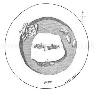
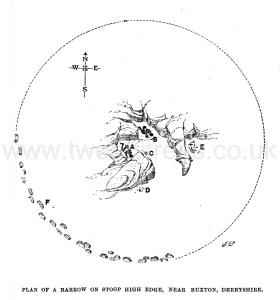
Proceedings of the Society of Antiquaries 1896 Dec 17 Stoop High Edge. In September, 1894, the Messrs. Salt made a series of excavations in a ruined round barrow [Stoop High Edge Barrow [Map]], of some 60 feet in diameter, upon this hill. Its outline was most noticeable on the south-west side, where several rows of large limestones, standing on end and inclining inwards, still remained ; the relics, undoubtedly, of a once continuous revetment or podium, behind which were piled up the loose materials (weathered limestones from the moor around) of the cairn. As frequently has happened in this district, the bulk of both cairn and its enclosing circle had been removed for the sake of the stone, and by this means some protruding rocks, around which the barrow had been reared up, had been exposed. The diggings of Messrs. Salt proved that the recesses between these rocks had been used as shallow graves. The interments, which I will describe in the order of discovery, were about one foot deep, upon the natural surface, and simply covered up with loose stones. All the human remains were much decayed and more or less disturbed, so that the skeletons on the accompanying plan, which is taken from Mr. W. H. Salt's notes, must be regarded as indicating their original, and not their actual condition as found.
Europe, British Isles, North-Central England, Derbyshire, High Peak, Buxton, Taddington
Europe, British Isles, North-Central England, Derbyshire, High Peak, Buxton, Taddington, Priestcliffe Low Barrow [Map]
Priestcliffe Low Barrow is also in Peak District Bronze Age Barrows.
Arthur Jewitt 1811. Chelmorton Lowe lies about five miles to the south east of Buxton, and about two-and-a-half to the north east of it lies Presley or Priestcliffe Lowe [Map], on the top of a hill a good deal similar is appearance to that of Chelmorton. Like Chelmorton, this has also been opened for the sake of the stone of which it is composed, and like it, has been re-closed when human bodies were discovered. Indeed these depositories of the dead, are so similar in their formation, that a dcscription of one may almost be assumed as an account of all.
Stephen Glover 1831. It is very probable from the derivation of the names of many villages in this county ending in the syllable Low that they were sacred places in the time of the Druids and may be supposed to contain barrows not hitherto discovered. We may rely upon this conclusion with more certainty as barrows have been opened at Wardlow [Map] and Hurdlow [Map]. The Swarkstone Lows con sisted formerly of three very large mounds but one of them has been levelled by the plough and the other two remain in very great preservation. At this ancient pass a battle was undoubtedly fought although history makes no mention of such an occurrence. At the small village of Priestcliff is a low [Priestcliffe Low Barrow [Map]] situate on a lofty eminence surrounded by a deep valley and on this emi nence there is a singular well fed by a clear spring which is said never to fail. On the top of the Great Finn in the township of Taddington there are many ancient British remains.
Thomas Bateman 1846. On the 1st of September, 1846, was opened an apparently large barrow near Taddington, called Priestcliffe Lowe [Map]; on being dug into, the rock was found to extend almost to the surface of the barrow, and the light covering of soil and stones, to have been previously disturbed; nothing having been overlooked but a small piece of a very neatly-ornamented urn and a few burnt bones.
Europe, British Isles, North-Central England, Derbyshire, High Peak, Buxton, Taddington, Slipper Low Barrow [Map]
Slipper Low Barrow is also in Peak District Bronze Age Barrows.
Taddington. On the 22nd of April, we opened a small barrow on elevated land near Taddington, called Slipper Low [Map], which was only about six yards diameter. It covered an irregularly shaped grave, cut in the rock, about eighteen inches deep containing an adult skeleton, extended on its back, with the head to the north-west. The bones were much decayed from the grave having been filled with tempered earth, which led us to conclude that the interment had taken place at a late period, although no implement whatever was found to indicate the era.
Europe, British Isles, North-Central England, Derbyshire, High Peak, Buxton, Thirkel Low Round Barrow [Map]
Thirkel Low Round Barrow is also in Peak District Bronze Age Barrows.
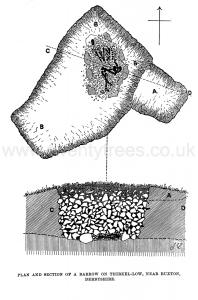
Proceedings of the Society of Antiquaries V15 1895. Thirkel-low Frith [Map] is a hill of about the same altitude as Grinlow, three miles south of Buxton. The barrow on its summit, which Messrs. Salt opened on May 8th, 1894, is about 55 feet in diameter, and is constructed of broken limestone thrown together without any apparent order. Very much of the central portion was carted away for the sake of the stone in 1840. By removing more stone from this area, Messrs. Salt soon discovered human bones extremely decayed, but sufficiently perfect, nevertheless, to make it evident that the skeleton Jay on its right side in the usual flexed posture, with the head to the east. It appeared to be quite unprotected, lying upon a sloping shelf of rock. The massive mastoid processes of the skull, and the prominent linea aspera of the femurs, indicated a powerfully built person.
A little to the north of this interment were the remains of a child, so scattered that it was quite impossible to determine the original posture. Near where the head lay, however, were a small plain blue glass bead, several teeth of the dog, the lower jaw of some animal, and some fragments of coarse hand-made black pottery. These were of ordinary ancient British character, and belonged to a small plain vessel of the ' food vase' form.
Proceedings of the Society of Antiquaries 1896 Dec 17 Thirkel Low. On July 18th, 1895, the Messrs. Salt and myself excavated a round barrow, 42 feet in diameter, upon this hill [Thirkel Low Round Barrow [Map]]. It was of considerable interest, for the construction of both the mound and the receptacle of its primary interment admitted of full and easy determination. As in the preceding barrow, part of its edge, that from east to south-west, was well defined by large stones set on end and inclining inwards. These were obviously the remnants of a former podium consisting of such stones in actual contact with one another ; but the mound did not appear to have ever been completely surrounded by the stones, for its north and north-west portions consisted mainly of rock, the outer face of which continued the circle. Within this podium, weathered limestones from the surrounding waste had been piled up without any order whatever. At the time of our excavation, the surface, in spite of its many irregularities, presented a general slight convexity, which probably approximated to its original form and height a shallow truncated cone with slightly domed top, the podium forming the shoulder. The preliminary investigation showed that the mound had not been much disturbed. A Mr. Webster made several slight excavations in 1894, and Mr. Salt a shallow trench (A on the accompanying plan and section from my notes on the spot) ; both found a few scattered bones.
Europe, British Isles, North-Central England, Derbyshire, High Peak, Buxton, Upper Edge Barrow [Map]
Upper Edge Barrow is also in Peak District Bronze Age Barrows.
Vincent Knoll. On the 28th of June, we opened a barrow [Upper Edge Barrow [Map]] on the "Upper Edge," near Sterndale, the top of which was of stone, and the lower part entirely of earth. About the centre were many pieces of charcoal, extending from a little below the turf, to the natural surface, a depth of about three feet. Amongst the charcoal were numerous pieces of calcined bone, and a few bits of flint; and from the appearance of the earth in the vicinity of the charcoal, it was judged that the process of combustion had taken place upon the spot.
Europe, British Isles, North-Central England, Derbyshire, High Peak, Buxton, Waggon Low Barrow [Map]
Waggon Low Barrow is also in Peak District Bronze Age Barrows.
Waggon Low. On the 25th of June, we proceeded to the top of a hill near High Needham, called Waggon Low [Map], where we found some indications of an artificial mound, the dimensions of which could not be ascertained, on account of the numerous rocky protuberances around it. By excavation, we found that several interments had been placed between the masses of rock, which had originally been covered by the mound. The first discovered lay on its left side upon the rock, at the South side of the barrow, at the depth of about eighteen inches from the surface, with the knees drawn up, and the head towards the S.W.; immediately in front of this skeleton were two iron knives, respectively 5¼ and 8⅛ inches long, lying in contact with each other; there were also several tips broken from the tines of stags horns, some other imperfect animal bones, and part of a quern, which had been used as a sharpening stone, in the vicinity of the skeleton, which was that of an aged person, one of whose legs had been fractured, and reunited immediately above the ankle. Pursuing the excavation towards the north, the rock was found to have been cut out to the further depth of 18 inches, so as to form a large irregularly shaped grave; at the end nearest the first discovered skeleton, there was a large stone, under which was a deposit of calcined bones, accompanied by a small arrow-point of flint, and a rude instrument of bone, and in an angle of the rock close by, was a small vase of coarse clay, slightly ornamented, 4½ inches high. Next to this deposit were the bones of a full-grown person and an infant, both much decayed, but we considered the former to have been laid with the head to the east, they were destitute of relics, and were very imperfect, though they did not appear to have been disturbed. Immediately in contact with them, we observed the feet of another skeleton, which being carefully uncovered, was seen to lie on its right side, with the legs gathered up, and the skull to the north; at the right shoulder were three instruments of light-coloured flint and a small bronze awl, 1½ inch long, tapering each way from the middle, which is square - also the leg bone of a dog. The skeleton is that of a young person slightly above the middle height, the jaws containing the full number of teeth, which are but little worn; it is in beautiful preservation, and having been articulated, is preserved in a glass case at Lomberdale [Map]. Two flat stones were set up on edge behind it in the barrow, and it was imbedded in earth, to which it owed its preservation. During the progress of these researches, we observed the ground at the west side of the trench to have been disturbed yet lower, but were unable to follow up the indication, from the approach of evening; therefore, on the 28th of June, we again visited the spot, and after removing stone to the depth of 4 feet 6 inches, found that the grave assumed the shape of the letter L the lower limb representing the western portion, now under examination, where we discovered the skeleton of a good sized man of middle age, lying on his left side with the knees drawn up, and the head towards the west, embedded in tenacious clay, above which was a thick layer of charcoal. The whole grave was carefully cleared out to its extremest limits without further result, except the discovery of numerous rats' bones, and of occasional portions of those of larger quadrupeds, such as horses' and swine's teeth.
 Bateman's original notebook on display at Weston Park Museum, Sheffield.
Europe, British Isles, North-Central England, Derbyshire, High Peak, Buxton, Wormhill [Map]
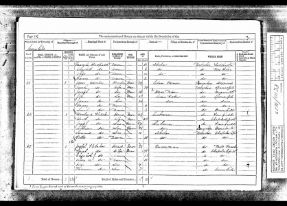
1871. Census. Wormhill [Map].
Joseph Fletcher (age 41). 35. Quarryman.
Sarah Yates (age 35). Wife. 35.
John Fletcher (age 9). Son. 9.
Joseph Fletcher: In 1830 he was born to John Fletcher at Peak Forest. In Jul 1911 he died at Chapel en le Frith.
Sarah Yates: In 1836 she was born. In 1923 she died.
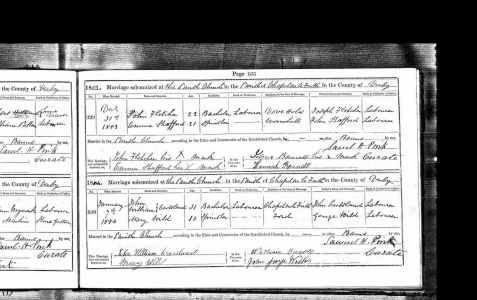
On 31 Dec 1883 John Fletcher (age 21) and Emma Stafford were married at St Thomas Becket's Church, Chapel en le Frith [Map]. He was resident at Dove Holes [Map], she at Wormhill [Map].
Europe, British Isles, North-Central England, Derbyshire, High Peak, Buxton, Wormhill, Bole Hill Barrow [Map]
Bole Hill Barrow is also in Peak District Bronze Age Barrows.
Thomas Bateman 1846. On the 15th of August 1846, another barrow [Bole Hill Barrow [Map]], on higher ground, a little farther on the opposite side of the road to Buxton, was opened. Its diameter is greater than that of the last, but, like it, is surrounded by a circle of very large stones. In the centre was an erection of very large flat stones, regularly walled in courses, and having for its base a piece of rock four feet by five, and one foot thick, approaching to a ton weight, so that if the earthy part of this barrow had been carefully removed so as to leave these stones undisturbed, there would, according to the old school of antiquarianism, have been a complete druidical circle, with a cromlech or altar for human sacrifices standing in the centre; more particularly, as the flat stone at the top of the central pile had a considerable inclination towards one side, which peculiarity in similar structures has been gravely accounted for as an intentional provision to carry off the blood of the unfortunate victims now and then sacrificed by the Druids. But to return to the funereal discoveries made in this barrow; on removing the aforesaid large stone, a few pieces of an unusually coarse urn, some calcined human bones, and the remains of a host of rats, with here and there a skull of the weasel, appeared; though level with the surrounding field, the earth under the stone was loose, and had been removed to form a cist, 'which had for its floor a level surface of rock, some three feet below the natural soil, and which was neatly walled round with flat stones; in this grave was a skeleton of large dimensions, lying on its left side, in a contracted posture; behind the head was a brass dagger of the usual type, measuring six inches and a quarter in length, and in the highest preservation; it has the appearance of having been silvered, and still retains a brilliant polish; when deposited it had been inclosed in a wooden sheath, the remains of which were very perceptible at the time of its discovery. Near it were two instruments of flint, and two more were found during the progress of the examination of the tumulus.
Europe, British Isles, North-Central England, Derbyshire, High Peak, Buxton, Wormhill, Bole Hill Barrow 2 [Map]
Bole Hill Barrow 2 is also in Peak District Bronze Age Barrows.
Thomas Bateman 1846. On the 19th of August 1846, was opened a barrow [Map] [Note. Bole Hill Barrow 2 [Map]] near the last, much mutilated by the removal of a quantity of stone for fencing, at the time of the inclosure of the common, when, if report be true, two celts of bronze were here discovered. A considerable portion of the circle still remaining, gave hopes of something still untouched, and to be obtained without much labour; but upon examination, the unremoved part of the mound proved to be mainly undisturbed rock, slightly covered with stones and soil, amongst which were found two skeletons, one male, the other female; the former lay close to the turf, and was of course much decayed and broken; the latter was deeper, in fact, it lay upon the surface of the rock, and was in much better preservation; near them were some small pieces of flint, and one small piece of an urn. Below that part of the tumulus that had been carried away was a small deposit of calcined bones, accompanied by those of the rat.
Europe, British Isles, North-Central England, Derbyshire, High Peak, Buxton, Wormhill, Higher Bibbington [Map]
1891. Census. Higher Bibbington [Map]. No. 3. Second Row.
John Fletcher (age 29). Head. 29. Quarryman.
Europe, British Isles, North-Central England, Derbyshire, High Peak, Buxton, Wormhill, Wind Low Barrow [Map]
Wind Low Barrow is also in Peak District Bronze Age Barrows.
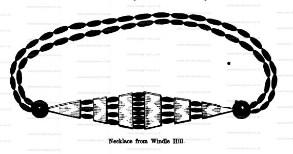
Thomas Bateman 1846. On the 12th of August 1846, was opened a low flat barrow at Windle (Wind Lowe) Nook [Map], near Hargate Wall, Derbyshire, about twenty yards in diameter, two feet high, and encircled by a ring of large flat limestones, placed in a sloping manner on one side, about three yards from the margin of the tumulus, apparently for the purpose of preserving its symmetry. The top of this barrow is surmounted by a large square sandstone, which has originally formed the base of one of the wayside crosses, of which numerous examples remain in the north of Derbyshire. About the centre of the barrow was a cist, measuring near six feet by four, in horizontal area, and three feet in depth, of unusual construction, the sides being built of large stones set on end, some of which appeared above the turf; an examination of the contents of this cist led to the conclusion that it had been applied to sepulchral purposes at various distinct periods, and that the last interment had been partially disturbed at a comparatively recent period; the contents were as follows: small pieces of urn, calcined bones and flints, skeletons of two persons of full stature, and of two infants, one of them very young, and various animal bones, amongst which, those of the rat, weasel, and horse were most conspicuous. All these articles were so much out of their ordinary arrangement, as to leave no doubt of their disinterment at the time of the burial of another skeleton, which lay in a contracted position a few inches above the floor of the vault; this skeleton, which, from the ornaments discovered with it, and the slender proportions of the bones, must be attributed to a female, had not entirely escaped spoliation at a recent period; the following circumstances seem to put this question beyond doubt, namely, the discovery of sundry pieces of tobacco-pipe, and nails from rustics' shoes, and from the fact of finding part of a very large ivory pin, and a fragment of an armilla or bracelet of Kimmeridge coal, both of which would undoubtedly have been perfect at the time they were deposited. Whoever these former excavators were, they were not very close observers as they had overlooked a necklace of beads of the aforesaid Kimmeridge coal, terminated by two perforated conical studs of the same, and enriched by six pieces of ivory, ornamented with the everlasting chevron or zig-zag pattern so universally prevalent on Celtic remains. The beads, exclusive of the studs and ornaments, are seventy-six in number, and are identical with two that are figured in plate 3, vol. i of Sir. Richard Hoare's excellent work. The ivory ornaments are quite novel, no other example having been published.
Note. The necklace discovered at Wind Low on display at Weston Park Museum, Sheffield.

Europe, British Isles, North-Central England, Derbyshire, High Peak, Buxton, Wormhill, Withery aka Withered Low Barrow [Map]
Withery aka Withered Low Barrow is also in Peak District Bronze Age Barrows.
Thomas Bateman 1846. On the same day two barrows on a very elevated piece of land on Wormhill Moor, known by the name of Whithery Lowe [Map], were opened; the smallest is situate on the highest point of the hill, and is formed almost entirely of soil, with here and there a stone. In it no symptoms of sepulchral remains were observed. The larger one is nothing more than the base of a considerable tumulus which has been removed to within eight inches from the natural soil; in the centre there was still remaining a cist, with a level floor formed of a slab of limestone; in this were the remains of two bodies, one of them a female, both which had been broken and disturbed at the time of the removal of the upper portion of the barrow.