Europe, British Isles, North-Central England, Derbyshire Dales, Chelmorton, Five Wells Chambered Tomb [Map]
Five Wells Chambered Tomb is in Chelmorton [Map], Peak District Neolithic Burials.
Between 4000BC and 2000BC. Five Wells Chambered Tomb [Map] is one of the oldest monuments in Derbyshire. It's location is prominent being at the top edge of the limestone scarp that rises to form the Derbyshire limestone plateau. There remains two cists aligned east-west and substantial remains of the original mound.


 View looking South with Minning Low Chambered Tomb [Map] clearly visible. On the right just visible is Arbor Low.
 View looking north with the Bull Ring Henge [Map] visible just left of centre.
 The signpost on Pillwell Lane with Five Wells in the distance.
It is a curious fact that Five Wells Chambered Tomb [Map] is, within 0.2 of a degree of longitude, north of Stonehenge [Map] - see Five Wells Chambered Tomb and Stonehenge Alignment. Moreover, this line of longitude, give or take 500m, has the highest number of Neolithic and Early Bronze Age Monuments on it when compared to other lines of longitude. North to South:
Five Wells Chambered Tomb [Map]
Monkton Fields Long Barrow [Map]
Netheravon 6 Long Barrow [Map]
James Pilkington 1789. About a quarter of a mile north east from Chelmorton a barrow or low [Chelmorton Low Round Barrows or Five Wells Chambered Tomb [Map]] was examined in the year 1782, and several particulars have been communicated to me respecting its external appearance, and inward construction.
The barrow, which I shall now attempt to describe, is a small circular mount, whose circumference at the base measures about seventy-five yards. Its height is seven feet. At the top is a hollow resembling a bason. Upon measuring down one side to the bottom, and ascending the opposite it was found to be eight yards across. But its perpendicular depth was no more than three feet. — A knowledge of its inward construction was obtained by some labouring men, who were searching for stone to build a walled fence in a neighbouring field. After removing a thin covering of moss and soil from the lower extremity or skirts of the mount, they discovered a kind of breast-work or regular wall of single stones formed without mortar. Not apprehensive of meeting with any thing extraordinary beyond this wall they proceeded in their work, but were soon surprized by the sight of several human bodies. They found, that the wall was the end of a cell or coffin, in which the bodies had been deposited. The breadth of the cell within was two feet, but its depth was not fully ascertained. It was supposed to be about a yard. The sides consisted of stones eight inches thick, and about two feet wide. They were placed upon their edge, and formed a kind of wall or partition. The stones used for the covering were from one to three inches thick, but not large.
Though some of the stones, and a small quantity of the soil had fallen into the vault, yet several human bodies or skeletons might be clearly distinguished, lying at full length with their heads towards the center of the mount. The bones had never been disturbed, and were apparently united together at the different joints, but by the slightest motion were found to be entirely loose and unconnected. — Upon examination they were discovered to be remarkably strong and sound. The ribs in particular were so little decayed, that they would easily bend without breaking. Those who saw the bones, thought that they were uncommonly large. It was imagined that the persons, to whom they belonged, must have been, when alive, at least seven feet high. The teeth were found, and perfect. From the number of bones and skulls, and the dimensions of the vault it was supposed, that it contained about four or five human bodies.
Though only one vault was opened and examined, it was presumed, that others were carried throughout the whole circumference of the mount: And from the width of that, which I have described, it was calculated, that there are about twenty in number.
Arthur Jewitt 1811. Between these two lowes a little to the south-west of the wall which is erected for a sheep-lay, in an inclosure called the Burying Close belonging to the farm of Mr. Ralph Mosley, is the remains of what has not only been a sepulture [Five Wells Chambered Tomb [Map]], but apparently a temple, similar to that of Arbor-lowe [Map], which Mr. Pilkington proves to have been of Druidical origin. Like that, it seems to have been composed of two concentric circles, one of large flat stones, and the other of soil or earth, with a shallow ditch, of which there are at present few traces. The diameter of the inner circle is about 25 yards, and from east to west a number of stones of large dimensions are now standing, and which most probably have been covered over with other stones, as in other barrows, cells or receptacles for dead.
That this should not have been a lowe or barrow only; is pretty evident from the following considerations: These works were always, or generally erected on the very apex of the hills, whereas this is on the southern side of the same hill which Chelmerton Lowe is situated, and like that at Mount St. Helier in the Isle of Jersey, which General Conway was at the expence of bringing over to England, and erecting in his own ground at Park-Place, as a singular curiosity, had in all probability been covered over with earth, to preserve it from destruction at the time when the Romans over-ran the country, and polluted or razed every sacred edifice.
In comparing this with the plate which Mr. Robertson has given of the St. Helier one at Park-place, there seems to be a great similarity in their formation, with the exception that by being rebuilt in the exact manner in which it was found, it has a more perfect appearance than this, mutilated as it is by the neighbouring labourers for walling stone.
When it was first discovered, a workman had by chance laid bare an open entrance to the east, composed of two large upright stones, with an impost over them; he ventured to enter, but meeting with a corpse or two (at that time in perfect preservation), he retreated, and informing his fellows of what he had seen, numbers came to look at the place, and soon spread a report of its containing many bodies, and, as a certain consequcnce, of its being haunted; this however, in time died away, and neither bodies nor goblins have been able to preserve it from an almost total destruction.
Thomas Bateman 1846. On the summit of Five Wells Hill [Map], near Taddington, is one of the most perfect examples now existing of the sepulchral architecture of the aboriginal inhabitants of Britain; it consists of two vaults situated in the centre of a cairn about thirty yards in diameter, each approached by a separate gallery or avenue, formed by large limestones standing edgeways, extending through the tumulus, respectively in a south-east and north-west direction. This structure appears to have been first discovered at the time of the inclosure of the moors, when a great part of the barrow was used in making the surrounding fences; at this time many bones were found in the vaults.
On the 25th of August, 1846, the two galleries were cleared out, in order to ascertain if any articles had been overlooked by the parties who first opened the barrow; but, with the exception of a flint arrow-point, and numerous bones, some calcined, nothing of primitive date was discovered. The quantity of bones of both sexes and of various ages indicate this tumulus to have been used as a burying-place for a considerable time; on this occasion the lower jaws of twelve different persons were collected.
Journal of the British Archaeological Association Volume 7 1851. Although not more than a third of the crania were recovered in a perfect state, yet in each instance the same extraordinary elongation was most apparent; as it is also in skulls from the following chambered cairns, described in a former part of my printed journal, namely, Bull Hill, on Bakewell Moor; Stoney Low, on Brassington Moor; and some others of a similar character.
The remains of chambered tumuli [Five Wells Chambered Tomb [Map]] near Monyash, Taddington (Plate XVIII, fig. 3), and at Minninglow, may be cited as fine examples of this class of sepulchre; they are all of great size, and though much mutilated, are highly interesting, and well worth the trouble of a visit from archaeologists who have leisure.

Frederick Lukis 1865. May 1865. Captain Lukis writes as follows: - Buxton, May, 1865. Whilst roaming with Mr. Anderson in this neighbourhood, I soon perceived in various places unmistakeable signs of ancient occupation and remains, particularly in the vicinity of Chelmorton; on enquiry, I learnt that two largish cairns had been examined by the late Mr. Thomas Bateman. On strolling near the spot I found several portions of human bones in the debris and the soil, and on looking beyond from the height on which I stood I could discover other objects which I deemed worthy the notice of the antiquary. In thus pursuing my way across the country, I suddenly perceived, in the corner of a field, some stones having an artificial arrangement, and as I approached I found to my great delight a beautifully formed little cist [Five Wells Chambered Tomb [Map]]. I now send you a sketch of it from recollection, for I was not at the time provided with materials for a more accurate detail. I soon found that it had been opened, and the interior of it was filled with stones and weeds; the side props are of good dimensions and apparently not disturbed. I then quitted this pretty piece of ancient remains very reluctantly, and I felt my old taste for the 'Primevals' reviving in full force.
Frederick Lukis 1865. May 1865. On Tuesday, we however returned to it, and spent a long day at the Five Wells [Map], and being now furnished with the proper materials for exploring this interesting spot, we soon perceived that it contained a series of cists. I now send you a ground plan, and request to refer you to my first letter, wherein I gave you an account of our abrupt and accidental discovery of this spot.
We first opened ground in the direction from A to B, and dug some two to three feet below the surface. We then came to a regular pavement of flat stones, on these we found the remains of two or three individuals very much decayed - two human jaws in tolerable preservation lying on the floor - a few bones and the teeth of a dog or badger. The teeth of oxen and those of the horse were dispersed among the debris, but no pottery or anything else worth noticing. At D on the plan, I wish you to remark a transverse prop placed as a termination or divisional boundary to the pavement, which came home to it-this we have often remarked in the sepulchral tombs of Brittany and the Channel Islands. Between the side props of this trough from A to B, there appeared a dry walling connecting them in one line, as observable in other places. E E E were stones capable of serving for covering stones to this trough, and we conceived that they had been removed from their original position at some period when the cairn was disturbed or examined. F is the cist first seen, and the side prop G, on the south side, is a fine slab 7 ft. 8 in., by about 7 in. breadth and 18 in. in thickness.
This cist must have formed a very perfect little tomb, and probably distinct from the occupants of the trough on the west of it, as to date and quality of the being deposited therein; but these varied modes of sepulture might rather denote a different period of interment in the same mound, which has been proved in many localities in England and other countries.
We then left this spot to its lonely genius, but the kind farmer who lives in the place and farms the land informed me that he had resided there upwards of 24 years, and had never known any examination of the spot during that period1;he, however, added that an old man, who had worked upon the land before he came to reside there, had told him that once in digging for stones in the same mound, he had discovered several pots and skeletons, with plenty of human teeth.
The present upright stones, which first attracted my notice are from four to five feet above ground, they are important enough from a distance to an experienced eye, but being near the corner of the field with a high stone wall near them they would be rather concealed from view.
I then visited the cottage of George Walker, who resides near, and who, on inquiry, informed me that he had found many flint arrow heads, which he described very accurately, as well as two or three celts, mentioning the place where they were found. He further added that had he time he could discover plenty more! As I knew the places indicated by this man I make little doubt of the truth of his statement. Had the weather been more favourable I should have been disposed to attempt the search for these, for in this county flints are the exception, amidst the fragments of limestone and toadstone.
The longest celt discovered by Walker is now in the possession of Mr. Bateman. This man gave me a very fair flake of flint, which greatly confirmed his account of these materials.
This interesting episode in my present journey to Buxton has proved one of great delight and a relaxation from the duties of a camp life, and our recent Indian campaign. I indeed felt truly happy in again following that pursuit which you have taught us almost from our cradle to take delight in, and when we received orders from head quarters to join our regiment at Manchester and to bark for Ireland, we felt well nigh broken-hearted. My companion, who now begins to be almost as much interested in these pursuits as myself, only consoles himself with the hope that some future opportunity may occur to bring him again in this interesting neighbourhood.
Llewellynn Jewitt.
Note 1. In this "the kind farmer" was certainly wrong. In 1846 the place was examined by my late friend Mr. Bateman, who, in his "Vestiges of the Antiquities of Derbyshire," page 91, thus records the fact: - "On the summit of Five Wells Hill, near Taddington, is one of the most perfect examples now existing of the sepulchral architecture of the aboriginal inhabitants of Britain: it consists of two vaults situated in the centre of a cairn, about thirty yards in diameter, each approached by a separate gallery or avenue, formed by large limestones standing edgeways, extending through the tumulus, respectively in a south-east and north-west direction. This structure appears to have been first discovered at the time of the inclosure of the moors, when a great part of the barrows were used inmaking the surrounding fences; at this time many hones were found in the vaults. On the 25th of August, 1846, the two galleries were cleared out in order to ascertain if any articles had been overlooked by the parties who first opened the barrow; but, with the exception of a flint arrow point, and numerous bones, some calcined, nothing of primitive date was discovered. The quantity of bones of both sexes, and of various ages, indicate this tumulus to have been used as a burying-place for a considerable time; on this occasion the lower jaws of twelve different persons were collected.
In 1851, Mr. Bateman, in a communication to the British Archæological Association, alluded to this tumulus, and sent up a drawing and ground plan, which are engraved in the Journal of the Association, Plate XVIII. Vol VII.
In 1862, I myself made a partial examination of the place, the result being simply the discovery of one or two fragments of pottery, and a flint. I give on Plate II. (fig. 3) a ground plan, with measurements, which I made of the principal chamber.
The place had previously, in 1810, been visited by my father, the late Mr. Arthur Jewitt, and described by him in his "History of Buxton". He therein says that when the cists were first discovered, a workman, I presume in getting stone, "by chance laid bare an open entrance to the east, composed of two large upright stones, with an impostover them," and, venturing in, found a skeleton or two in perfect preservation. Retreating he told his fellow-workmen what he had seen, "and numbers came to look at the place, and soon spread a report of its containing many bodies, and, as a certain consequence, of its being haunted. This however in time died away, and neither bodies nor goblins have been able to preserve it from almost total destruction." At that time (1810) myfather made a rough sketch and ground plan of the place, and of these I give reduced copies on Plate II. ( figs. 1 and 2 ), and also, on the same plate ( fig. 4), I give the ground plan as taken by Mr. Bateman when he examined the cists in 1846. A further and more detailed account of this interesting chambered tumulus, and of others of the same general character, will be given in a future number.


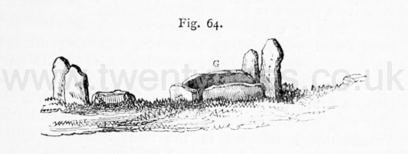
Llewellynn Jewitt 1870. The chambered tumulus, called the "Five Wells [Map]," near Taddington, of which an engraving is here given (fig. 64), has been a mound of large size, and the chambers and passages, or gallery, have been extensive. A plan of this tumulus is given in fig. 65. The "Five Wells [Map]" tumulus consists of two vaults or chambers, situated near the centre of a cairn (which is about thirty yards in diameter), each approached by a separate gallery or avenue, formed by large limestones standing edgeways, extending through the tumulus, respectively in a south-east and north-west direction. These chambers are marked B and G on the plan, G being the cist engraved on fig. 64. E E E are stones supposed to be the capstones thrown down. Another five-chambered tumulus in the same county is called Ringham-Low [Map], which has many interesting remains.
Between 1899 and 1901. Found at Five Wells Chambered Tomb [Map] collected by M Salt (age 52). In the collection of Buxton Museum and Art Gallery [Map].
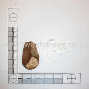 Flint Scraper
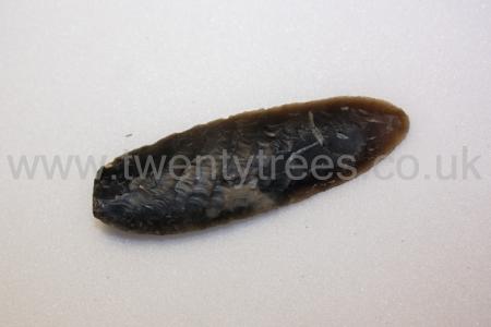 Flint knife
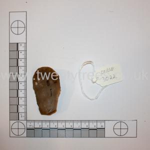 Flint tool or fabricator
John Ward 1901. Five-Wells Tumulus, Derbyshire [Map] by John Ward.
This remarkable tumulus is two miles S.W. of Miller's Dale Station, on the Midland Railway between Derby and Manchester, and one-and-a-quarter from Taddington. It crowns a conspicuous and breezy knoll on the northern brow of an elevated stretch of fields (from 1,320 ft. to 1,440 ft. above the sea-level) between the above village and that of Chelmorton, which a century or more ago was waste land, and which still retains the name of Taddington Moor. The whole district is of carboniferous limestone, and, as might be expected, the view from the knoll is an extensive and characteristic stretch of Peak scenery. The name, "Five-Wells," has arisen from the circumstance that in the vicinity, five fields so about upon a spring that each has a drinking-place or "well" supplied therefrom. The name is also applied to a farmhouse near.
In its present condition, the tumulus is circular, from 60 to 70 ft. in diameter, with a well-defined outline, but with a low and irregular grassy summit. A little east of the centre is a fine half-buried (strictly, half-unburied) megalithic chamber minus its roof. It is constructed of ponderous weather-worn limestones; and between it and the eastern side of the mound several of the side-stones of a former passage or gallery, by which access was had to the chamber, peep above the sward. The accompanying drawing (fig. 1) will give a general idea of this old-world structure. West of the centre this arrangement of chamber and access-gallery was reproduced, but in reversed order, the entrance being in the western side of the tumulus ; their remains, however, are scanty. It is clear that these chambers with their galleries were originally covered by the mound, and there is reason to think that they all formed parts of one design and construction.
It is evident that the upper part of the mound was removed for the sake of its stone at the time the moor was enclosed, and that this process included the breaking-up of some of the large stones of the chambers and galleries. The mutilated tumulus then served as a convenient spot on which to deposit rubbish, as ashes and broken pots, derived, without doubt, from the neighbouring farmhouse, and surface stones from the surrounding fields, have been found on the south side. These potsherds were of the wares in common use towards the close of the eighteenth century.
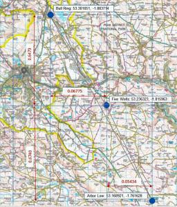
Arbor Low Five Wells Bull Ring Monument describes a possible prehistoric single monument formed from Arbor Low Henge and Stone Circle [Map], Five Wells Chambered Tomb [Map] and the Bull Ring Henge [Map] that form the same shape as the constellation Orion's Belt.
Other prehistric monuments including the Thornborough Henges, and, possibly, the Giza Pyramids appear to be similar. There are theories about there being a 'Cult of Orion' around 2400BC. Both Arbor Low Henge and Stone Circle [Map] and Bull Ring Henge [Map] can be seen from Five Wells Chambered Tomb [Map] albeit not with the naked eye during daylight - a camera with a long lens is needed. In darkness a bonfire would make both easily visible.
Taking the positions of each map from Historic England's listing the angle between the monuments is 172 degrees which is consistent with the angle of Orion's Belt. The angle of Orion's belt may have changed over time - difficult to find an exact figure. And, of course, difficult to be precise as to the centre of each monument so error is likely. I couldn't find a description of the linear distance between the stars seen from earth. If anyone has better information please email email@twentytrees.co.uk.
Five Wells Chambered Tomb [Map]. Historic England:
Five Wells chambered tomb is situated on Taddington Moor on the limestone plateau of Derbyshire. The monument includes a roughly circular burial-mound measuring 23m by 22m and surviving to a height of c.1m. Originally the mound would have been somewhat higher, but most of the surface was robbed of its stone in the eighteenth century. Stone was also taken in the late nineteenth century from the western part and a number of pits on the south side were created in the mid-twentieth century when material was taken for hard-core. Visible today are the remains of two limestone orthostat chambers, situated back to back and orientated east-west with approach passages leading from the western and eastern edges of the mound. These internal features have paved floors and were covered by a cairn measuring 16m by 14.5m which was built of horizontally laid limestone slabs and covered in turn by a mound of earth and stone. In addition to the recovery of skeletal remains and pottery by workmen prior to the mid-eighteenth century, there have been four partial excavations of the monument carried out by Bateman in 1846, Jewitt in 1862, Lukis in 1865 and Salt between 1899 and 1901. Bateman recovered the remains of at least twelve individuals in the two chambers along with burnt bones and a flint, while Jewitt found pottery and a flint and Lukis found the remains of three skeletons in the western passage. Salt found further human remains within the chambers and passages along with flint implements, which included a leaf-shaped arrowhead and a plano-convex knife, and sherds of pottery of the types known as Neolithic plain ware and Peterborough ware. A barbed and tanged arrowhead was found on the surface of the mound and Salt also uncovered a cist in the north-western part of the monument which was placed outside the cairn but within the earth mound. This contained a contracted inhumation and, along with another inhumation and some burnt bone found in a pit in the top of the mound, is believed to be a secondary burial. The architectural features and archaeological remains indicate that the barrow was in use from the Early Neolithic, with a period of re-use either in the Late Neolithic or to the Bronze Age.