Avebury Bronze Age Barrows
Avebury Bronze Age Barrows is in Avebury, South England Bronze Age.
Europe, British Isles, South-West England, Wiltshire, Bishops Canning, Easton Hill Round Barrow [Map]
Wiltshire Archaeological Magazine 1859 V6 Pages 317-336. Further east, on the summit of Easton Hill, are a long barrow [Easton Hill Long Barrow [Map]], and one of a fine bell-shape [Easton Hill Round Barrow [Map]].
12. In this last [Easton Hill Round Barrow [Map]], at the depth of two feet, was a grooved pin of bone two inches long, and a few scattered teeth and animal bones. At six feet was a large pile of burnt bones, probably those of a male; and below and around these, a quantity of wood ashes.
13. The long barrow [Easton Hill Long Barrow [Map]], of moderate size, ranges almost due east and west, has the usual slight trench on the north and south sides, not continued round the west or east end, which last is the highest and widest part of the mound. There were marks of former diggings at the east end, near which a large opening was made down to the natural soil. Here, were the scattered bones of four human skeletons, two adult males, and two apparently young persons. The teeth were much worn, the erosion being most marked on the outer edges of the lower, and inner edges of the upper, teeth. There were also a few chippings and fragments of Sarsen stones.
Europe, British Isles, South-West England, Wiltshire, Bishops Canning, Horton Down Round Barrow [Map]
Wiltshire Archaeological Magazine 1859 V6 Pages 317-336. 14. On Horton Down, about half a mile further east, is a single barrow [Horton Down Round Barrow [Map]] of low elevation, in which, at a depth of two feet, was a simple deposit of burnt bones.
Europe, British Isles, South-West England, Wiltshire, Kitchen Barrow Hlll, Kitchen Hill Bowl Barrow [Map]
Kitchen Hill Bowl Barrow [Map]. Historic England 101426.
The monument includes a barrow situated 800m east of Kitchen Hill Long Barrow [Map]. It forms the southern outlier of a cemetery which includes a total of five barrows. This is one of a number of cemeteries located on the Downs. The barrow has a mound which has been reduced by cultivation in the past but which survives as a visible monument, best seen from the east. It measures 12m in diameter and up to 0.6m high. The western half of the barrow has been reduced to the point where it is no longer clearly definable at ground level. This difference in survival of the mound, which originally stood at least 0.9m high, is due to the fact that it is crossed from north east to south west by a fence line which forms the parish boundary and the extent of cultivation either side of the boundary has been variable. Surrounding the original extent of the mound is a 2m quarry ditch from which material was obtained during its construction. This survives as a buried feature below the modern ground level. Beyond the ditch lies a 1.5m wide counter-scarp bank which stands 0.3m high on the eastern side of the monument. It has been levelled to the west. During the late 1850s the barrow was partly excavated and a secondary cremationburial was found, placed on a flat stone beneath an inverted Late Bronze Age bucket urn.
Europe, British Isles, South-West England, Wiltshire, Alton Barnes, Knap Hill Barrow 1 [Map]
Wiltshire Archaeological Magazine 1859 V6 Pages 317-336. 11. A small barrow, under cultivation, somewhat more to the west and not more than a foot in height, presented no trace of interment, after careful investigation
To the east of Walker's Hill is Knap Hill [Map], having on its summit a small defensive earthwork or camp. At the foot of this, (close to the road to Kennet, and to the line of the old British trackway which stretches by Avebury into Berkshire) are two defaced barrows [Knap Hill Barrow 1 [Map] and Knap Hill Barrow 2 [Map]] connected by a dyke, extending sixty yards east and
19. To the south of the eastern mound, is a small low barrow not two feet in height. In digging into it, a few pieces of burnt bone were found, and near the centre, the carelessly buried skeleton of an infant. On the west side of the barrow, in a narrow cist in the chalk, more than six feet long, was the skeleton of an adult female of large stature, stretched at length, the feet to the east, as in Christian cemeteries at the present day;
"Mindful of Him who in the orient born
There lived, and on the cross His life resigned;
And who from out the regions of the morn
Issuing in pomp shall come to judge mankind."1
Note 1. Wordsworth, it is true, here alludes to the orientation of churches; but there can be no doubt that similar views have determined the position of the dead in Christian cemeteries. The great mediaeval ritualist, Durandus, thus writes: "Debet autem quis sic sepeliri ut, capite ad occidentem posito, pedes dirigat ad orientem: in quo quasi ipsa positione orat et innuit quod, promptus est ut de occasu festinet ad ortum." De Divinis Officiis: quoted by Abbe Cochet, Arch. vol. xxxvi. p. 261
Europe, British Isles, South-West England, Wiltshire, Alton Barnes, Knap Hill Barrow 2 [Map]
Wiltshire Archaeological Magazine 1859 V6 Pages 317-336. 11. A small barrow, under cultivation, somewhat more to the west and not more than a foot in height, presented no trace of interment, after careful investigation
To the east of Walker's Hill is Knap Hill [Map], having on its summit a small defensive earthwork or camp. At the foot of this, (close to the road to Kennet, and to the line of the old British trackway which stretches by Avebury into Berkshire) are two defaced barrows [Knap Hill Barrow 1 [Map] and Knap Hill Barrow 2 [Map]] connected by a dyke, extending sixty yards east and
19. To the south of the eastern mound, is a small low barrow not two feet in height. In digging into it, a few pieces of burnt bone were found, and near the centre, the carelessly buried skeleton of an infant. On the west side of the barrow, in a narrow cist in the chalk, more than six feet long, was the skeleton of an adult female of large stature, stretched at length, the feet to the east, as in Christian cemeteries at the present day;
"Mindful of Him who in the orient born
There lived, and on the cross His life resigned;
And who from out the regions of the morn
Issuing in pomp shall come to judge mankind."1
Note 1. Wordsworth, it is true, here alludes to the orientation of churches; but there can be no doubt that similar views have determined the position of the dead in Christian cemeteries. The great mediaeval ritualist, Durandus, thus writes: "Debet autem quis sic sepeliri ut, capite ad occidentem posito, pedes dirigat ad orientem: in quo quasi ipsa positione orat et innuit quod, promptus est ut de occasu festinet ad ortum." De Divinis Officiis: quoted by Abbe Cochet, Arch. vol. xxxvi. p. 261
Europe, British Isles, South-West England, Wiltshire, Alton Barnes, Knap Hill Barrow 3 [Map]
Wiltshire Archaeological Magazine 1859 V6 Pages 317-336. 20. This last, to the south-west of the earthwork, is not more than a foot high. An opening, of at least three yards square, was made in the centre; but excepting some animal bones near the summit, nothing was found after a most careful search.
21. The simple bowl barrow at the west end of the camp [Knap Hill Barrow 3 [Map]], is about two feet high and surrounded by a slight trench. Near the summit, were a few bones of a sheep and perhaps other ruminants, such as are commonly found in this position in the barrows of Wiltshire: they are probably the relics of funeral feasts or of sacrifices over the graves. In the centre, was a circular cist in the chalk rock, two feet in diameter and two feet deep, nearly full of ashes and burnt bones, but without any other relic. At the east end of the camp, the ground has been much disturbed by digging for flints, and no trace of any barrow remains.
Europe, British Isles, South-West England, Wiltshire, Fyfield, Manton Barrow aka Preshute G1a [Map]
Manton Barrow aka Preshute G1a [Map] is a Bronze Age Round Barrow excavated by Howard B. Cunnington and Maud Cunnington née Pegge who discovered a number of significant artefacts including gold artfacts. See Wiltshire Archaeological Magazine 1907 V35 Pages 1-20.
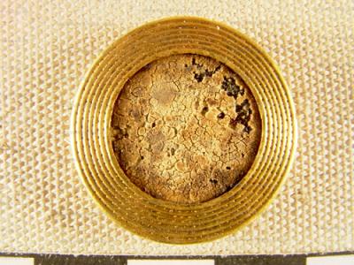
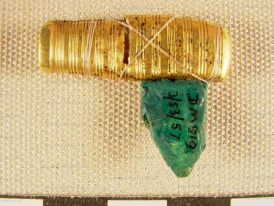
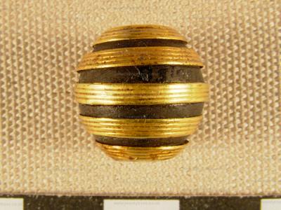
Wiltshire Archaeological Magazine 1907 V35 Pages 1-20. Notes on the Opening of a Bronze Age Barrow at Manton [Manton Barrow aka Preshute G1a [Map]], near Marlborough By Mrs M E Cunnington (age 37).
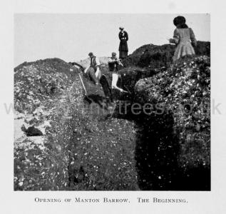 Opening of the Manton Barrow. The Beginning.
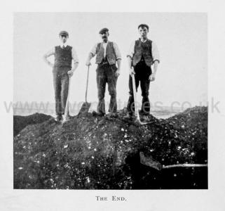 The End.
Europe, British Isles, South-West England, Wiltshire, Bishops Canning, Roughridge Hill Round Barrows [Map]
Wiltshire Archaeological Magazine 1859 V6 Pages 317-336. There are several groups of barrows, mostly of small size, on the Downs to the east of Shepherd's Shore, close to Wansdyke on the north. The first of these [Shepherd's Shore Round Barrows [Map]], near the road, consists of three very small mounds, two of which had been opened before.
6. In the third, at a depth of two feet, was the skeleton of a tall female in a shallow cist, in the usual contracted posture, with the head to the north: under the turf were a few teeth of an ox. Nothing else was found.
About a quarter of a mile to the east, on Roughridge Hill [Roughridge Hill Round Barrows [Map]], are two groups, the first consisting of four, the other of three low mounds.
7. In the second of the first group, counting from the south, at the depth of a foot, was a deposit of the burnt bones of a female or young person. The other three had been previously opened by Mr. William Cunnington, and all found to cover interments after cremation.
In each of the more northernly group of three, we also found deposits of burnt bones:
8. In the first, these were at the depth of between three and four feet, mixed with a few ashes, and with fragments of sun-dried pottery, of both the coarse and finer sorts. There were also two pins of ivory, one of them tinged with bronze.
9. This yielded nothing beyond a heap of burnt bones, on the surface of the chalk.
10. In this, at a depth of two feet, was a small deposit of incinerated bones, with much burnt wood and ashes, and likewise a small cup of ornamented but coarse sun-dried pottery, and a perforated bead of bone or ivory an inch long. At a distance of two feet on the same level, was the jaw of a pig, and in another place a bone or two of an ox.
11. A single barrow on the slope of the hill about half a mile to the north of the last, (marked on the Ordnance Map, but not on those in "Ancient Wilts,") at the depth of two feet, yielded a few burnt bones, a fragment of black pottery and a tooth or two of an ox.
Europe, British Isles, South-West England, Wiltshire, Bishops Canning, Shepherd's Shore Round Barrows [Map]
Wiltshire Archaeological Magazine 1859 V6 Pages 317-336. There are several groups of barrows, mostly of small size, on the Downs to the east of Shepherd's Shore, close to Wansdyke on the north. The first of these [Shepherd's Shore Round Barrows [Map]], near the road, consists of three very small mounds, two of which had been opened before.
6. In the third, at a depth of two feet, was the skeleton of a tall female in a shallow cist, in the usual contracted posture, with the head to the north: under the turf were a few teeth of an ox. Nothing else was found.
About a quarter of a mile to the east, on Roughridge Hill [Roughridge Hill Round Barrows [Map]], are two groups, the first consisting of four, the other of three low mounds.
7. In the second of the first group, counting from the south, at the depth of a foot, was a deposit of the burnt bones of a female or young person. The other three had been previously opened by Mr. William Cunnington, and all found to cover interments after cremation.
In each of the more northernly group of three, we also found deposits of burnt bones:
8. In the first, these were at the depth of between three and four feet, mixed with a few ashes, and with fragments of sun-dried pottery, of both the coarse and finer sorts. There were also two pins of ivory, one of them tinged with bronze.
9. This yielded nothing beyond a heap of burnt bones, on the surface of the chalk.
10. In this, at a depth of two feet, was a small deposit of incinerated bones, with much burnt wood and ashes, and likewise a small cup of ornamented but coarse sun-dried pottery, and a perforated bead of bone or ivory an inch long. At a distance of two feet on the same level, was the jaw of a pig, and in another place a bone or two of an ox.
11. A single barrow on the slope of the hill about half a mile to the north of the last, (marked on the Ordnance Map, but not on those in "Ancient Wilts,") at the depth of two feet, yielded a few burnt bones, a fragment of black pottery and a tooth or two of an ox.
Wiltshire Archaeological Magazine 1885 V22 Pages 234-238. "Barrows Opened by Mr. Cunnington near Beckhampton, 1804.
"A group of barrows near Shepherds Shore [Map]. Mr. C. opened the smallest, which contained a cist with burnt bones and a jet ornament, a bone arrow-head, a pin, &c.
"Farther to the north-west, and under Morgan's Hill, is a group of four barrows, nearly in a line; but lower down the vale are several others. Opened the second from the hill — of the Druid kind — five feet in elevation — burnt bones and a piece of slate, and a neat little urn, also several long amber beads, and two ivory or bone beads. Opened a tumulus lower down — a large rude black urn with burnt bones.
Europe, British Isles, South-West England, Wiltshire, All Cannings, Tan Hill Barrows [Map]
Wiltshire Archaeological Magazine 1859 V6 Pages 317-336. Still further east, on St. Anne's [Map], or as it is commonly called, Tan Hill [Map]1, to the south of Wansdyke and overlooking the villages of Allington and All Cannings, are four barrows [Map], all of the bowl form, surrounded by shallow trenches.
Note 1. The vulgar name of Tan Hill has almost supplanted its proper designation of St. Anne's Hill, by which it is still known on the Maps. The great annual fair held here on old St. Anne's day, (Aug. 6th) is sufficient proof of the etymology, and of the unsatisfactory nature of the speculations of the late Canon Bowles and others, by whom its name was connected with that of the Celtic Jupiter, Taranis. —(Bremhill, 1828, p. 35; Hermes Brit. p. 14.) Stronger testimony may be derivable from Anglo-Saxon charters of the 10th century, of Edward the elder, Edwy and Edgar, in which, if Fosbroke's reading is to be accepted, mention is made, in describing the boundaries of the adjoining parish of Stanton, of "Anne's Thorn" and "Anne's Stone," probably on this very hill, (Hoare's Regist. Wiltun, p. 6; Cod. Dip. Nos. 335, 467, and 482). In^the 17th century, Aubrey writes of "St. Anne's Hill" as "vulgarly called Tann Hill, where every yeare on St. Anne's day (26 July) is kept a great fair, within an old camp." (Nat. Hist, of Wilts, p. 114). Mr. Duke, 'who thought the fair of St. Anne may have succeeded to the feriæ of Diana, observes "the corruption of St. Anne's Hill to Tan Hill is obviously thus, St. Anne's Hill — S'tan Hill — Tan Hill." (Druidical Temples of Wilts, 1846, p. 95.) There can be little doubt that this hill has been the site of pagan rites, but to what deity these were paid, there is, we think, no proof. The Beltein may likely enough have been here celebrated; but these midsummer fires were especially in honour of the solar god, Belin. The hill, it seems clear, derives its name from that of the patron saint of the parish church (All Cannings) viz. St. Anne.
Europe, British Isles, South-West England, Wiltshire, All Cannings, Tan Hill Escarpment Barrows [Map]
Wiltshire Archaeological Magazine 1859 V6 Pages 317-336. Three low barrows [Map], between St. Anne's Hill and Milk Hill, on the escarpment of the downs close to Wansdyke, were examined; in the first of which a few scattered bones of ruminants, and in the third, traces of incinerated bones were alone met with.
17. In the second, at a depth of two feet, were bones and teeth of sheep and oxen; at three feet two small pieces of deer's horn and a fragment of coarse black pottery, and at four and a half feet, two circular cists scooped out of the chalk rock, a foot or two apart, each two feet and a half in diameter. These were filled with grey ashes, with no distinct trace of burnt bone. Deposits of this kind, to the exclusion of interments, properly so called, have before been found in the barrows of Wiltshire, and are termed cineraria in the descriptions of Sir R. C. Hoare.
On Walker's Hill, Alton-Priors Down, near the very large long barrow [Map], by which it is distinguished1, are three small mounds [Map]; two of which disclosed marks of interment after cremation; they had been previously opened. The smaller one was not examined.
Note 1. Ancient Wilts, vol. ii. pp. 12, 46. Salisbury Vol. of the Arch. Inst. p. 98.
Europe, British Isles, South-West England, Wiltshire, Avebury, Windmill Hill Barrows
Europe, British Isles, South-West England, Wiltshire, Avebury, Windmill Hill Barrows, Windmill Hill Barrow 1 [Map]
Windmill Hill Barrow 1 [Map]. 15m across and 0.3m high. Surrounding the mound is a ditch from which material was quarried during construction of the monument. This has become infilled over the years but survives as a buried feature c.2.5m wide.
Europe, British Isles, South-West England, Wiltshire, Winterbourne Monkton 24a [Map]
Diary of a Dean by Merewether. No. 24a [Map]. In the small mound on the north side were teeth of deer, oxen, and bones, small fragments of charred wood, and a small sarsen stone partially rubbed.
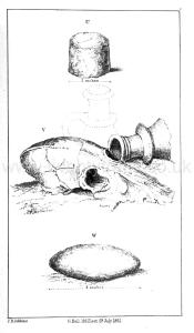
No. 25b In the opposite mound were similar remains, and in very considerable quantities; and in this was a sarsen (U) 3 inches in diameter rubbed down to a cylindrical form, and the front teeth of an ox.
No. 26c - Five different openings had been made in this long mound, which were afterwards conjoined, and formed one continuous cutting throughout. At 7 was a large half of the os frontis of an ox, and some fragments of horns of deer, one small tip of an ox's horn.
Note d. Here, at about a foot from the surface, was found the head of apparently a greyhound (V), and close by the side a fragment of a small ampulla of Koman form, but somewhat coarse pottery; below was a flat sarsen (W) rounded at the edge and slightly convex.
Europe, British Isles, South-West England, Wiltshire, Winterbourne Monkton 25 [Map]
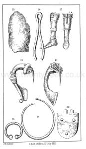
Diary of a Dean by Merewether. 25 [Map]. Side and front view of a singular bronze leg, having a groove to make a joint at the knee, and riveted to either limb. These bronze articles were found very near the line of the Roman road (Via Badonica). Could this be part of such a figure as we read of in Petronius? "Larvam argenteam attulit servus, sic aptatam ut articuli ejus vertebreeque laxatse in omnem partem verterentur," &c., pp. 115, 116. [The servant brought a silver skeleton, so fitted that its joints and vertebrae were loosened and turned in every direction]
Europe, British Isles, South-West England, Wiltshire, Winterbourne Monkton 28 [Map]
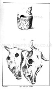
Diary of a Dean by Merewether. No. 28 [Map]. On removing the three sarsen stones from the apex, about a foot deep, appeared the fragments of a small ornamental urn (X) of unbaked and very fragile clay, containing the skull-bones principally of a very young person, the sutures not being joined or knit; near the top was a sarsen, rounded, and about 2 inches in diameter. The material of which this barrow was composed was chalk rubble, very coarse, and not mixed with other substances, as was generally the case, nor were there fragments of bones, or urns, or pottery, as observed in others. At the depth of 5 feet were (Y) the heads of two oxen laid side by side, and in very perfect condition, but very brittle on removal; from the pole to the nose-bone one measured 20 inches, the other 19; from one orbit of the eye to the other 9 inches; in each the centre of the forehead had been fractured in a circular hole. Below these the same hollow character of the chalk continued, and the sides of the chamber, 6 feet in length by 4 feet in breadth, had been carefully cut in the natural chalk. The heads of the oxen were laid across the chamber north-east. At a depth of 5 feet below these, and 10 feet from the top, was the skeleton of an adult (Z), in many parts much decayed, but in the crouched position, lying on the left side; behind the head was a small ornamented urn of unbaked clay (aa) or at least only fire-baked, and not in a kiln; the thigh-bone was 19 inches in length; at the right foot was a small well-chipped flint arrow-head (bb) and a flint spear-head (cc). A second also was subsequently found near the same spot (dd),though not so well formed.
