Iron Age Hill Forts Wiltshire
Iron Age Hill Forts Wiltshire is in Iron Age Hill Forts.
Barbury Castle
The Ridgeway Path is an ancient footpath that extends from Knap Hill [Map], on the south of the Avebury Plateau, or The Sanctuary [Map], to Ivinghoe Beacon, Buckinghamshire [Map] - a distance of more than eighty miles following the scarp slopes. From Knap Hill [Map] the Ridgeway Path passes The Sanctuary [Map], Avebury Ridgeway Path [Map] where a path leads to the Avebury Henge East Entrance [Map], Barbury Castle [Map], Liddington Castle [Map], Wayland's Smithy Long Barrow [Map], Uffington Castle and White Horse [Map], Segsbury Camp [Map], Scutchamer Knob, Oxfordshire [Map], Goring, Oxfordshire [Map], Swyncome, Oxfordshire [Map], Chinnor, Oxfordshire [Map], Princes Risborough, Buckinghamshire [Map], Boddington Hill Fort, Buckinghamshire [Map], Tring, Hertfordshire [Map], Ivinghoe Beacon, Buckinghamshire [Map].
Around 550BC. Barbury Castle [Map] is a Multivallate Hill Fort in Wiltshire located on the Ridgeway Path. It has two deep defensive ditches and ramparts. The site was first occupied around the 6th Century BC. In 1996 a geophysical survey revealed traces of forty hut circles inside the castle.
In 556 Cynric King Wessex and Ceawlin King Wessex defeated the Britons at Barbury Castle [Map] during the Battle of Beran Burg. Barbury Castle [Map] possibly of strategic importance since it is located on the Ridgeway with extensive views over the Thames valley.
Europe, British Isles, South-West England, Wiltshire, Bratton Camp [Map]
Wiltshire Archaeological Magazine 1872 V13 Pages 339-342. Dr. Thurnam began by observing that the Barrow on and around which those present were now standing, though placed in the centre of the British encampment, popularly known as Bratton Castle [Map] is probably of much earlier date, and has none but an accidental connection with that earthwork. It is a Long Barrow of large size, measuring 230 feet in length, lies east and west; and was opened by Dr. Thurnam in 1866. It belongs to the class of Long Barrows, a form of tumulus which differs essentially from the much more numerous Round Barrows, by which, on the Wiltshire Downs, they are everywhere surrounded. These latter, the Round Barrows, much more commonly than otherwise — at least three times as often — contain interments of burnt bodies, often accompanied by bronze weapons or implements,and especially bronze knives or daggers, and by ornaments of glass, amber, jet or shale, and gold. Sometimes there are flint and other stone implements, but these are all of a kind known to have been in use at the same time as those of bronze. The Round Barrows belong, essentially, and as a rule, to the Bronze Age of this country, and to an age of burning the dead. When the interment is that of the unburnt body — which, in Wiltshire, is less than one in four — the body has been buried with the knees bent and drawn up towards the chest. That the burnt and unburnt inter- ments are of one and the same period is proved by the similarity, or rather identity, of the accompanying implements and ornaments.
Europe, British Isles, South-West England, Wiltshire, Colerne, Bury Camp [Map]
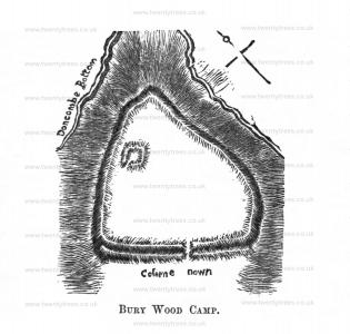
Wiltshire Archaeological Magazine 1856 V3 Pages 67-86. Bury Wood camp [Map], or North Wood camp, referred to by Whitaker as the probable Danish fortress, is in the parish of Colerne, on the borders of Grloucestersliire, and within about half a mile of the Roman road, the Fosse. "It has," says Aubrey, "double-works [and is] therefore not Roman." It contains about twenty-five acres, and is situate on a promontory of Colerne Down, from which it is separated by a double, deep rectilinear rampart, having a single entrance in the centre facing the south-west. The other sides, says the same writer, are well secured by the precipice, at the bottom of which runs a stream. Within the area is a small subsidiary earthwork, about an acre in extent, and with an opening facins: the west.1 The name of Doncombe Bottom, which attaches to the ravine below the camp, may possibly refer to the Danes.
Note 1. See a good plan in Hoare's "Ancient Wilts," vol. II, p. 103, from which our wood engraving has been reduced. See also "Roman Era," p. 103. For this engraving, and for that of Bratton Camp [Map], also reduced from a plate in "Ancient Wilts," vol. I., p. 55, the Committee of the Society are indebted to one of the members, the Rev. E. Meyrick.
Europe, British Isles, South-West England, Wiltshire, Upavon, Casterley Camp [Map]
Colt Hoare 1812. Proceeding a little further, I quit the ridgeway, and direct my course towards CASTERLEY CAMP [Map]. This earthen work bears the strongest marks of originality, and none of the modern signs of innovation. I consider it as a British town, but not so populous as either of those already noticed at STOCKTON and GROVELY. Here we find no deep or multiplied ramparts, but a simple ditch and vallum of no great elevation, enclosing an area of above sixty acres. The richness of its soil having induced the owner to devote it to tillage, many of the original works and excavations have been defaced, but we still in D. and E. recognize the works of the Britons; the former in its irregularity resembling others before noticed at STOCKTON and GROVELLY: the other, E., by having the ditch within the vallum, denoting probably a place appropriated to religious purposes. Many passages have been made through these works for the accommodation Of waggons; it is therefore difficult to state the original entrances: I rather doubt if C. was one, but can speak, I think, confidently respecting A. and B., though we do not: usually find two entrances so near to each other, and it would be reasonable to suppose there had been another entrance or exit at the northern end, where there are signs of some outworks, &c. The line of ramparts is most perfect and regular on the east side. On the south side, we may observe a bank and ditch issuing from the camp, which runs over the down, and bends towards the vale of Avon. The area of this camp contains above sixty-four acres; the circuit of the outer ditch is one mile and a quarter, and the depth of the vallum is twenty-eight feet. On the west side also, are the signs of another bank and ditch.
Note 1. We often meet with the names of Bodbury, and Badbury, evidently derived from the British word bod, a dwelling but in digging in the area of camp, Mr. Cunningtons could not find any pottery, or other signs of residence.
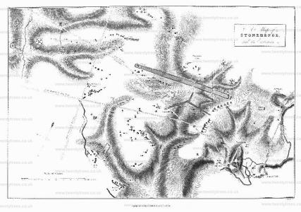
Wiltshire Archaeological Magazine 1885 V22 Pages 234-238. "The manoeuvres of the day being interrupted by the heavy fall of earth, I left Marden and ascended the chalk hills. The eye is caught by the remains of an ancient earthen work on the summit of the hill overlooking this fine vale. It is called Broadbury, Brodbury, &c. , &c. It has been much mutilated by chalk pits. It is single ditched — similar square excavations (containing fragments of the oldest pottery) to those on Cotley Hill, near Warminster, have been found here.
"These works are situated very near the great Ridge- way — see my map of Wilts. Turned off on the left, and continued my ride along it to Casterley Camp [Map]. Casterley much changed in its appearance, having been lately ploughed up. Nunc seges est ubi Troja fuit [Now the harvest is where Troy was]. Thence crossed the vale of Avon at Chisenbury, once the site of a priory. My trackway led me straight to the perfect little square work called Sidbury [Map]. Great British excavations in its neighbourhood. Saw on my right the beautiful twin barrows — before drawn and noticed. One remains to be opened. 'Par nobile fratrum [A noble pair of brothers].' Returned to Everley gratified and benefitted, as usual, by my ride amongst the Britons.
Europe, British Isles, South-West England, Wiltshire, Calne, Cherhill aka Oldbury Hill Fort [Map]
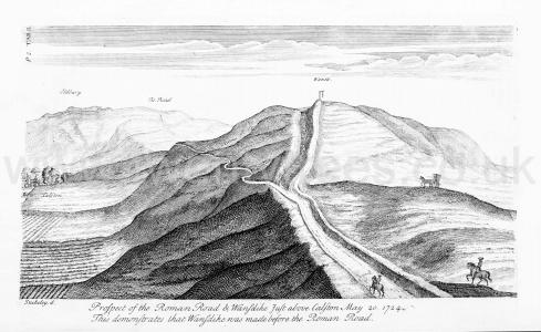
Stonehenge by William Stukeley. Table II. Prospect of the Roman Road & Wansdyke just above Caston May 20 1724. This demonstrates that Wansdyke was made before the Roman Road. [Note. Stukeley would have been stood here [Map] to record this view. Note the gibbet on top of Furze Knoll [Map]. On the left Cherhill aka Oldbury Hill Fort [Map].]
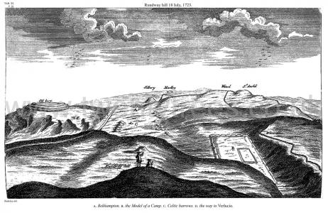
Avebury by William Stukeley. 18 Jul 1728. Table XI. Rundway hill 18 July, 1723. A. Bekhampton. B. the Model of a Camp. C. Celtic barrows. D. the way to Verlucio. [The drawing shows Silbury Hill [Map] and Cherhill aka Oldbury Hill Fort [Map]]
Europe, British Isles, South-West England, Wiltshire, Downton, Clearbury Ring [Map]
Clearbury Ring [Map] is a univallate Iron Age hillfort of two hectares occupying a prominent hilltop overlooking the valley of the River Avon. The rampart is well preserved and consisted of a single bank with a ditch outside it. The fort had a single entrance on the northwest side, consisting simply of a 10-metre (33 ft) wide gap with a causeway across the ditch.
Europe, British Isles, South-West England, Wiltshire, Warminster, Cley Hill [Map]
Cley Hill, Wiltshire [Map]Historic England:
The monument includes a large univallate hillfort, two bowl barrows, two flights of medieval strip lynchets and a cross dyke situated on Cley Hill, a steep sided Middle and Upper Chalk outlier of Salisbury Plain rising sharply from low lying clay land to the west of Warminster. The hillfort defences comprise a steep scarp up to 7m high surrounded by a flat berm up to 4m wide, enclosing an area of 7ha on the top of the hill. To the east and north east traces of an outer bank up to 3m high survive at the edge of the berm. Crossing the enclosed area, a scarp up to 1.7m high on a false crest of the hill, runs from north east to south west and may represent an earlier defence or a division within the hillfort. To the east there is a break in the ramparts where a natural bowl cut into this side of the hill provides a steep gradient on which defences were not necessary. To the south west a large post-medieval quarry has removed one corner of the hill, including most of the defences on this side, although some traces of the berm are still visible at the quarry base. At the summit of the hill is a large flat-topped bowl barrow. The mound of the barrow is 4m high and 28m in diameter, and is surrounded by a ditch from which material was quarried during its construction. This has become partially buried, but is visible to the north and south where it is 6m wide and 0.3m deep. The barrow was partially excavated by Sir Richard Colt Hoare and William Cunnington in the early 19th century, who found traces of wheat. Another bowl barrow 50m to the SSE comprises a mound 1.5m high and 22m in diameter surrounded by a quarry ditch 3m wide and 0.1m deep. This barrow was also partially excavated by Hoare and Cunnington who found an interment of burnt bone. The southern edge of the mound is crossed by a linear feature running from south west to north east, interpreted as a cross dyke. It comprises a bank 0.3m high and 2.2m wide flanked to the north by a ditch 0.1m deep and 1.1m wide. The cross dyke runs 170m from the edge of the quarry to the steep side of the hill to the east. Below the hillfort on the south and west sides are medieval strip lynchets, terraces built in order to cultivate on the slope, which rise up the gentle incline at the base of the hill. The steep risers, or scarps, stand up to 4m high while the flatter treads, which were cultivated, are up to 7m wide. All fence posts and cattle troughs are excluded from the scheduling, although the ground beneath these features is included.
Europe, British Isles, South-West England, Wiltshire, Figsbury Rings [Map]
Figsbury Rings is also in South England Henges, .
The earthworks of Figsbury Ring [Map] are sub-circular and enclose 6.4 hectares of grassland on a chalk ridge to the north east of Salisbury. The site is unusual for having an outer bank and ditch, the usual form of a henge monument in in addition it has an inner ditch which separates the centre from the rest of the monument. It may have been a Causewayed Enclosure, or a Henge, or both, with further modifications taking place at the start of the Iron Age when it may have been changed to a hill fort.
Colt Hoare 1812. CHLORLIS'S CAMP [Map], but in Mr. Aubrey's Monumenta Britannica, as well as in Mr. Camden's Britannia, it is noticed under the title of FRIPSBURY [Map]. What, the origin of the latter name is, I am at a loss to conjecture. The former may be derived from the British General CONSTANTIUS CHLORES, to whom, perhaps, the construction of this camp may be attributed. In Kennet's Parochial Antiquities, I find this earthen work alluded to, and some history given of its supposed founder. "After the death of Carausius, in the year 297, the Emperors Dioclesian and Maximian succeeded to the government of the empire, and in order to withstand the rebellions that broke out in divers parts of it, elected Galerius Maximus and Constantius Chlorus as their generals. The latter having defeated the usurper Allectus, got a good footing in Britain, and a good governor he was, and was come forwards upon the downs as far as New Sarum2, where, upon the side of the downs he built a fortification, the rampers whereof still appear very apparently, and is called CHLOREN, after the name that the Britons gave him, by reason of his long train carried up after him; it standeth in Wiltshire, upon the north corner of CHLORENDON Park, now called CLARENDON, which taketh is name thereof; a park of that largeness and bigness that it excecdeth any park in the kingdom; it hadi a church covered over with ivy in the north pan thereof next CHLOREN, which thereupon is now called Ivy Church: and if we give credit to a late poet, the park had twenty groves in it, each of them of a mile compass, and without any sophistication, it had a house of kings within, but long since dilapidated; it cloth now belong to the Right Honourable William Earl of Pembroke, Lord Chamberlain to his Majestie, whose heart is as large and liberal as the park is wide. This CONSTANTIUS embraced the Christian faith, and married Helena, daughter to King Coyl that built ColChester, by whom he had Constantine the Great, that removed the empire to the east, and built Constantinople."
Note 1. The following minutes Were sent to me Mr. Cunnington, respecting his researches on these barrows. "August 6, 1807. Aboüt a mile and a half south of Wilbary House, in a shallow vale, immediately under the hills to the is a group of five barrows; three bowl-shaped, and two of the Druid they stand nearly in a straight line, and owing to the ground being in tillage, have been repeatedly over, therefore much reduced in height. No. 1 is a bowl shaped barrow, 74 feet in its base diameter, and 3 feet 9 inches in elevation. It contained within an oblong cist, an interment of burned bones. over which was a brass pin. In making the sections, our men found at the depth of two feet the skeleton of a dog, which had been deposited immediately over the cist. No. 2, a bowl-shaped barrow, 69 feet in diameter, and feet in elevation, produced a little pile of burned bones, unaccompanied by any arms [?] or trinkets. No. 3, a fine Druid barrow, of the second class, contained a deposit of burned bones; but Mr. Cunnington thinks he may have missed the primary interment, or it may have been disturbed by a prior opening, No. 4 and 5 had both been examined before,
"From hence we proceeded to a group of eight barrows on Idmiston Downs, two of which are shaped, four bowl-shaped, and two Druid; all situated on a piece fine maide down. One of the bell-shaped barrows produced a simple interment of burned bones; and in the other, the sepulchral deposit was not discovered.
The fine Druid barrow contained within its area, which measured 194 feet in diameter, two raised mounds, in one of which, immediately under the turf, were discovered three large urns within few inches of each other; they were inverted, and covered the burned bones of three Britons. From being placed so near the surface, two of the urns were broken, but the third is preserved entire in our Museum at Heytesbury. They were all of rude pottery, and without any ornament. Beneath these three urns, in a shallow cist, were the burned bones of another Briton, piled up in R little heap. In the other within the same barrow, was another interment of burned bones, accompanied by the following articles, viz. a small cup similar size to the very diminutive one discovered at Everley, and engraved in Tumuli Plate XXII but without ornament; a brass pin, and a considerable quantity of amber beads." In one of the bowl-shaped barrows Mr. Cunnington railed in finding the interment, and the others he did not open.
Note 1. For New, we must read Old Sarum, as the former dates its origin only from the year 1220, and this transaction must have taken place soon after the accession of Dioclesian and Maximian to the empire in the year 304.
Wiltshire Archaeological Magazine 1925 V43 Pages 48-58. Figsbury Rings [Map]. An Account Of Excavations In 19241. By Mrs. M. E. Cunnington (age 55).
Europe, British Isles, South-West England, Wiltshire, Everleigh, Lidbury Camp [Map]
Lidbury Camp, Wiltshire [Map]. From Historic England: The monument comprises a possible barrow together with Iron Age and Romano-British occupation associated with Lidbury Camp and its related trackways.
Wiltshire Archaeological Magazine 1885 V22 Pages 234-238. "The manoeuvres of the day being interrupted by the heavy fall of earth, I left Marden and ascended the chalk hills. The eye is caught by the remains of an ancient earthen work on the summit of the hill overlooking this fine vale. It is called Broadbury, Brodbury, &c. , &c. It has been much mutilated by chalk pits. It is single ditched — similar square excavations (containing fragments of the oldest pottery) to those on Cotley Hill, near Warminster, have been found here.
"These works are situated very near the great Ridge- way — see my map of Wilts. Turned off on the left, and continued my ride along it to Casterley Camp [Map]. Casterley much changed in its appearance, having been lately ploughed up. Nunc seges est ubi Troja fuit [Now the harvest is where Troy was]. Thence crossed the vale of Avon at Chisenbury, once the site of a priory. My trackway led me straight to the perfect little square work called Sidbury [Map]. Great British excavations in its neighbourhood. Saw on my right the beautiful twin barrows — before drawn and noticed. One remains to be opened. 'Par nobile fratrum [A noble pair of brothers].' Returned to Everley gratified and benefitted, as usual, by my ride amongst the Britons.
Liddington Castle
The Ridgeway Path is an ancient footpath that extends from Knap Hill [Map], on the south of the Avebury Plateau, or The Sanctuary [Map], to Ivinghoe Beacon, Buckinghamshire [Map] - a distance of more than eighty miles following the scarp slopes. From Knap Hill [Map] the Ridgeway Path passes The Sanctuary [Map], Avebury Ridgeway Path [Map] where a path leads to the Avebury Henge East Entrance [Map], Barbury Castle [Map], Liddington Castle [Map], Wayland's Smithy Long Barrow [Map], Uffington Castle and White Horse [Map], Segsbury Camp [Map], Scutchamer Knob, Oxfordshire [Map], Goring, Oxfordshire [Map], Swyncome, Oxfordshire [Map], Chinnor, Oxfordshire [Map], Princes Risborough, Buckinghamshire [Map], Boddington Hill Fort, Buckinghamshire [Map], Tring, Hertfordshire [Map], Ivinghoe Beacon, Buckinghamshire [Map].
Around 650BC. Liddington Castle [Map] is a Late Bronze Age Early Iron Age Univallate Hill Fort in Wiltshire at altitude 277m sited on a commanding high point close to the Ridgeway Path covering an area of 30000 square metres. Its first occupation dates to around the 7th Century BC. The earthworks consist of a relatively simple oval bank of timber and earth fronted by a ditch, with opposing causewayed entrances on the east and west sides.
Europe, British Isles, South-West England, Wiltshire, Oare, Martinsell Hill Fort [Map]
Martinsell Hill Fort [Map]. Martinsell Hill, near Oare and north of Pewsey, is the third highest point in the county of Wiltshire, southwest England, at some 289m above sea level. At the summit is an Iron Age univallate hillfort of 32 acres with a clearly visible bank and ditch system. The entrance appears to be to the northeast where there is also a ditch.
Europe, British Isles, South-West England, Wiltshire, Great Durnford, Ogbury Camp [Map]
Colt Hoare 1812. From this camp, I descend into the vale of the Winterbourns, which is thickly strewed with villages: the adjacent lands are all in a state of cultivation, and afford no food for the antiquary. Crossing the Roman road, whose line is but faintly to be distinguished, I direct my course to the adjoining vale of the river Avon, on the eastern banks of which is a spacious earthen enclosure, bearing every mark of remote British antiquity, and known by the name of OGBURY CAMP [Map]. On this hill we recognize the very early and simple handiwork of the Britons, unaltered by their successors and conquerors, the Romans and Saxons. Here we see a large tract of 62 acres enclosed within a single rampart, and without any fosse to strengthen it against the attacks of an enemy; and we see within the area the evident marks of enclosures, and only one entrance towards the east. On the northern side the ramparts followed the windings of the hill, and are interrupted by the plantations belonging to Lord Malmesbury's demesne at Great Durnford1 in which parish this earthen work is situated. The area contains 62 acres and a quarter: the circuit of the outward ditch is one mile, one furlong, and fifty-five yards, and the depth of the vallum is 33 feet. On the south-east and west sides, the ramparts are very much mutilated, and in some places nearly levelled. I cannot consider OGBURY as a camp, or work of defence against an invading enemy, but rather as an asylum or place of refuge, whither the Britons, in times of danger, retired with their families and herds of cattle. Such I am glad to find it was considered by the learned Stukeley, who, in his Itinerarium Curiosum, page 138, thus notices it. "On the east side of the river Avon, by Great Durnford, is a very large camp, covering the whole top of a hill, of no determinate figure, as humouring the height it stands on: it is made entirely •without any ditch, the earth being heaped up very steep in the nature of a parapet, when dug away level at the bottom. I doubt not but this was a camp of the Britons, and perhaps an oppidum, where they retired at night from the pasturage upon the river, widl their cattle; within it are many little banks carried straight, and meeting ane another at right angles, square, oblong parallels, and some oblique, as the meres and divisions between ploughed lands; yet it seems never 10 have been ploughed; and there is likewise a small squarish work intrenched, no bigger than a large tent; these to me seem the distinctions and divisions for the several quarters and lodgments of the people within; for I have, upon the downs in Dorsetshire, often remarked the like of too small a compass to be ploughed fields. This camp has an aspect very old; the prominent part of the rampart in many places quite consumed by time, though the steep remains perfect; one being the natural earth, the other factitious. I know not whether we ought to derive the name of it: from the British OG, signifying the hurdles and pens they fence their cattle in with, which perhaps stood upon those meres, or little banks, to distinguish every man's property.
Note 1. The parish church of this little village deserves the antiquary's notice. The north and south doorways present curious examples Saxon decoration, and the font is richly oroameilted with sculpture in the same style.
This church also retains another relick of ancient usage, though not of so remote a date. John Jewel, consecrated Bishop of Salisbury in the year 1560, published, in the year 1562, an Apology for the Church England, to which Harding published a Confutation in the following year. This was answered by Bishop Jewel, in 1564, in a book, entitled A Defense the Church England work was held in such estimation both abroad and at home, that an order was issued by Queen Elizabeth, King James, and King Charles the First, and by four successive Archbishops, that it should bc read and chained up in all parish churches throughout England and Wales. One of these books in a wooden binding, and chained to a reading desk, still exists in the parish church of Great Darnford.
Colt Hoare 1812. I am again happy to do justice to the accuracy of the learned Doctor's description as to the general appearance of OGBURY CAMP [Map], but I cannot attribute the same consequence, or antiquity which he does, to the little square work, which "as no bigger than a tent," for I dug into it, and found no ashes, no bones, no pottery: and I can consider it only as a slight embankment to protect some trees which might have been planted on this very conspicuous eminence in former years. I dug also in several parts within the area of the enclosure, but found no one symptom of ancient residence: but that it was connected with some British establishment in this neighbourhood, can have doubt: and I was fortunate during my researches in these parts to discover and investigate that settlement of the Britons, which existed on some high ground adjoining the camp, and whose site is marked on the map annexed to this Station. The extraordinary verdure of the turf induced me to try the efforts of the spade and pick-axe, for the plough bad at some very distant period nearly levelled the excavations so usually concomitant with British villages; and I was not deceived by these outward appearances; for we immediately, under a rich and black soil, dug up numerous bones of animals, with fragments of the rudest British pottery.
Europe, British Isles, South-West England, Wiltshire, All Cannings, Rybury Camp [Map]
Rybury Camp, Wiltshire is also in Avebury Causewayed Enclosures.
Rybury Camp, Wiltshire [Map]. English Heritage:
This monument includes a causewayed enclosure and slight univallate hillfort situated on the summit of a very steeply sloping and prominent downland ridge called Clifford’s Hill. The causewayed enclosure survives as an oval interior defined by two concentric oval banks with causeways and an outer partially buried ditch with similar causeways which have been surrounded and partially overlain by the earthworks of the slight univallate hillfort. The inner rampart of the causewayed enclosure stands up to 1m high and encloses an area measuring 130m long by 100m wide. It is surrounded by a second bank which survives as a scarp of up to 2.3m high with an outer ditch of 0.2m deep and 3m wide. This second rampart encloses an inner area of approximately 180m long by 160m wide. The slight univallate hillfort is also oval in plan and surrounds the earlier earthworks on all except the north east side. It is defined by a single rampart bank of up to 1.1m high with an outer ditch of up to 1.5m deep and has a single southern entrance. The interior measures approximately 190m long by 150m wide. The whole interior and ramparts relating to both structures have been disturbed by pits associated with post medieval chalk extraction which give an overall uneven appearance. A trial trench in 1963 yielded over 600 flint flakes, a few bones and teeth. Chance finds in 1964 and 1967 included Neolithic pottery. However, the site was more fully understood following extensive field survey in 1995 when its complex development was revealed.
Europe, British Isles, South-West England, Wiltshire, Stonehenge Landscape, Stonehenge Monuments and Burials, Vespasians Camp [Map]
Vespasians Camp [Map] is an Iron Age Hill Fort with an area of 14 hectares.
Stonehenge by William Stukeley. Table III. Prospect of Stonehenge from the East by Vespasians Camp [Map]. [From left to right, being south to north. Yansbury Camp [Yarnbury Castle [Map]?], who location is unknown, Stonehenge, Stonehenge Avenue [Map], Cursus and N Long Barrow.
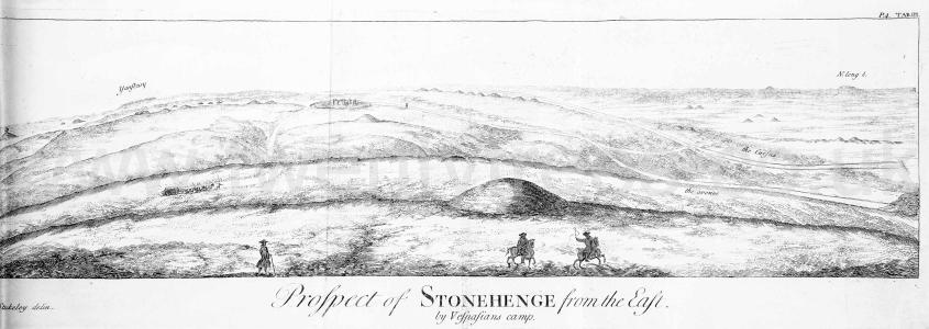
Stonehenge by William Stukeley. In order to have a just notion of this avenue, it is necessary to go to the neighbouring height of Haradon hill [Map], on the other side the river. The largest barrow there, which I call Hara's and which probably gave name to the hill, is in the line of the avenue; the ford of Radfin lying between, as we see in the last Plate. I stood upon this hill May 11. 1724. during the total eclipse of the sun, of which I gave an account in my Itinerarium. Here is a most noble view of the work and country about Stonehenge. Whoever is upon the spot cannot fail of a great pleasure in it; especially if the fun be low, either after rising or before setting. For by that means the barrows, the only ornaments of these plains, become very visible, the ground beyond them being illuminated by the suns flaunting rays. You fee as far as Clay-hill beyond Warminster 20 miles off. You fee the spot of ground on the hill, whereon stands Vespasians camp [Map], where I conjecture the avenue to Stonehenge began, and where there was a facellum, as we conceive. From hence to that spot a valley leads very commodiously to Radfin [Map], where the original ford was.
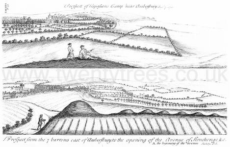
Stonehenge by William Stukeley. Table XXVI. Prospect of Vespasians Camp [Map] near Amberfbury. Augst 7. 1723. Prospect from the 7 barrows east of Amberfbury to the opening of the Avenue of Stonehenge & c. A. the beginning of the avenue [Map]. [This appears from the text to be a view from Haradon aka Telegraph Hill [Map]]
Europe, British Isles, South-West England, Wiltshire, Berwick St John, Winkelbury Camp [Map]
Pitt-Rivers. EXCAVATIONS IN WINKELBURY CAMP [Map], SOUTH WILTSHIRE.
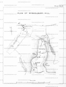
Wessex from the Air Plates 2 and 3. Winkelbury [Map] is an interesting camp built on a chalk spur projecting northwards over the village of Berwick St. John. It is divided into two parts by a cross rampart, its northern area is dotted with pits, and the highest part of the area is over 100 ft. above an encircling rampart which has in many places slipped and foundered into its ditch below. It is convenient to compare Hambledon with Winkelbury, for Winkelbury was excavated by General Pitt-Rivers (Excavations in Cranborne Chase, ii), and his conclusions may be briefly summarized.
He found a good deal of pottery of various types, all of which he considered to be contemporary and pre-Roman; one type was new to him. All the pottery was distributed over the area of the camp and under the rampart: whoever built the camp must have been responsible for the pottery, for no relics pointing to a later date were found except a few fragments of Romano-British pottery which were admitted to be without significance. It is possible to look upon Winkelbury as built as a whole and not reconstructed afterwards.
Although Pitt-Rivers was unable to identify some of the pottery he found at Winkelbury, it is now known that it is comparable with that discovered by Captain and Mrs. Cunnington at All Cannings Cross and assigned by them to the transition period when the culture of the Early Iron Age was beginning to replace that of the Bronze Age, and its date in Wiltshire is about 500 B.C. Mrs. Cunnington, commenting on the pottery from Winkelbury, says: 'All the Pottery from Winkelbury illustrated in Plate CLVIII (Excavations in Cranborne Chase, ii) with the exception of Figs. 7 and 10, Romano-British wares, might have come from All Cannings Cross' (All Cannings Cross, p. 198).
Yarnbury Castle
Yarnbury Castle [Map] is a multiphase, multivallate Iron Age hillfort that covers an area of 11.5 hectares.