Stonehenge Bronze Age Barrows
Stonehenge Bronze Age Barrows is in Stonehenge Bronze Age.
Europe, British Isles, South-West England, Wiltshire, Stonehenge Landscape, Stonehenge Barrows, Amesbury Barrows, Amesbury Barrow 12 G11a [Map]
Colt Hoare 1812. No. 12 [Map] is a group of small tumuli, in one of which, immediately under the turf, we found a very rude urn, badly baked, and containing ashes, burned bones, and two pieces of twisted brass wire, which probably once formed a ring: this urn was not inverted. We attempted to open another, but finding that, together with the remainder Of the group, it had been ploughed over, we gave up our researches, as, owing to the slight elevation of these barrows above the level of the ground, their contents would most probably have been destroyed by the continued operations of agriculture.
Europe, British Isles, South-West England, Wiltshire, Stonehenge Landscape, Stonehenge Barrows, Amesbury Barrows, Amesbury Barrow 13 G11e [Map]
Colt Hoare 1812. No. 13 [Map] is a Druid barrow, which contained a simple interment of burned bones.
Europe, British Isles, South-West England, Wiltshire, Stonehenge Landscape, Stonehenge Barrows, Amesbury Barrows, Amesbury Barrow 15 G10 [Map]
Colt Hoare 1812. No. 15 [Map], is a Druid barrow, in which we found a deposit of burned human bones within a cist. It had been opened before, and some scattered fragments of bone, led us to suppose that a skeleton had been found, though the other interment had escaped unnoticed.
Europe, British Isles, South-West England, Wiltshire, Stonehenge Landscape, Stonehenge Barrows, Amesbury Barrows, Amesbury Barrow 16 G4 [Map]
Colt Hoare 1812. No. 16 [Map] is a mutilated flat barrow, 76 feet in diameter, and only 3 Feet in elevation. This appears to have been one of those opened by Dr. Stukeley, and thus mentioned by in his account of STONEHENGE (page 46). "And in a very great and old fashioned barrow, west from STONEHENGE, among such matters, I found bits of red and blue marble chippings of the stones of the temple; so that, probably, the interred was one of the builders." During our researches in this tumulus, we perceived that a long section had been made, and found the bones of two skeletons which had been interred in the floor, also several pieces of stag's horns, animal bones, kc. as well as some fragments of sarsen stones, similar to those which form the great trilithons of STONEHENGE. On clearing out the earth from this section, we observed a small heap of whiter soil, which having removed, we came to the primary interment of burned bones within a fine circular cist, and found a spear head of brass in fine preservation, and a pin of the same metal. It is somewhat singular, that these burned bones (a more than usual quantity) should have laid unmolested in barrow where there were a hundred rabbit holes. On removing the earth from over the cist, we found a large piece of one af the blue stones of Stonehenge, which Sowerby the naturalist calls a horn stone, which, with the sarsen stone, is a very singular occurrence, and decidedly proves that the adjoining temple was erected previous to the tumulus, Some persons acquainted with the soil in this part of Wiltshire, might think the finding of sarsen stones no uncommon event, and I should perhaps have thought the same, had these specimens been rounded by attrition; but the stones found within this barrow, are pieces chipped off, (l sorry to say) like those now daily knocked off from the great fallen trilithon. With regard to the blue stone, we are certain this species is not to be found in the southern district of Wiltshire. In opening the fine bell-shaped barrow N. E. of STONEHENGE, also found one or two pieces of the chippings of these stones, as well as in the wagon tracks round the area of the temple. These circumstances tend to give a much higher æra of antiquity to our celebrated building, than some antiquaries would be willing to allow, and evidently prove that at the period when the tumuli adjoining STONEHENGE were raised, the plain was covered with the chippings of the stones that had been employed in the formation of the stone circle.
Europe, British Isles, South-West England, Wiltshire, Stonehenge Landscape, Stonehenge Barrows, Amesbury Barrows, Amesbury Barrow 17 G10a [Map]
Colt Hoare 1812. No. 17 [Map] is a long barrow, in which we made no discovery.
Europe, British Isles, South-West England, Wiltshire, Stonehenge Landscape, Stonehenge Barrows, Amesbury Barrows, Amesbury Barrow 18 G5 [Map]
Colt Hoare 1812. No. 18 [Map] is injured by rabbits.
Europe, British Isles, South-West England, Wiltshire, Stonehenge Landscape, Stonehenge Barrows, Amesbury Barrows, Amesbury Barrow 19 G6 [Map]
Colt Hoare 1812. No. 19 [Map] seems to have been onc of those opened either by Lord Pembroke, or Dr. Stukeley, who had been successful in finding the interment in an oblong cist.
Europe, British Isles, South-West England, Wiltshire, Stonehenge Landscape, Stonehenge Barrows, Amesbury Barrows, Amesbury Barrow 20 G8 [Map]
Colt Hoare 1812. No. 20 [Map]. This barrow had been opened before, and contained the interment of a skeleton.
Europe, British Isles, South-West England, Wiltshire, Stonehenge Landscape, Stonehenge Barrows, Amesbury Barrows, Amesbury Barrow 21 G7 [Map]
Colt Hoare 1812. No. 21 [Map] and No. 22 [Map] were unproductive.
Europe, British Isles, South-West England, Wiltshire, Stonehenge Landscape, Stonehenge Barrows, Amesbury Barrows, Amesbury Barrow 22 G9 [Map]
Colt Hoare 1812. No. 21 [Map] and No. 22 [Map] were unproductive.
Europe, British Isles, South-West England, Wiltshire, Stonehenge Landscape, Stonehenge Barrows, Amesbury Barrows, Amesbury Barrow 23 G11 [Map]
Colt Hoare 1812. No. 23 [Map], Mr Cunnington attempted to explore this fine bell-shaped barrow some years ago, but was unsuccessful. On a second trial, I found that in his former operations he had left off a few inches of a large rude sepulchral urn inverted over a pile of burned bones, amongst which was an elegant pair of ivory tweezers.
Europe, British Isles, South-West England, Wiltshire, Stonehenge Landscape, Stonehenge Barrows, Amesbury Barrows, Amesbury Barrow 24 G39a [Map]
Colt Hoare 1812. No. 24 [Map] is a very flat barrow, in which were the skeletons of an adult and a child, deposited in a very shallow cist, and which had been disturbed by a prior opening.
Europe, British Isles, South-West England, Wiltshire, Stonehenge Landscape, Stonehenge Barrows, Amesbury Barrows, Amesbury Barrow 25 G40 [Map]
Colt Hoare 1812. No. 25 [Map] is a wide bowl-shaped barrow, in which we found, within a shallow cist, a skeleton with its head towards the north, and a drinking cup by its right side, and near it a neatly formed pin or needle of bone.
Europe, British Isles, South-West England, Wiltshire, Stonehenge Landscape, Stonehenge Barrows, Amesbury Barrows, Amesbury Barrow 26 G39 [Map]
Colt Hoare 1812. No. 26 [Map] is situated on the borders of the turnpike road, and produced a large interment of burned bones on the floor, with a cone of jet, two oblong beads of the same substance, eighteen of amber, and a very small cone of the same.
Europe, British Isles, South-West England, Wiltshire, Stonehenge Landscape, Stonehenge Barrows, Amesbury Barrows, Amesbury Barrow 27 G41 [Map]
Colt Hoare 1812. From this camp, I shall direct my steps to the gap between the old and new King's barrows, near the former of which is a solitary tumulus, No. 27 [Map], which appeared to have had a prior opening, and to have contained originally, the skeletons of two adults, and two children. Round the arm one of the former was an ornamented bracelet of brass, which the labourers unfortunately trod upon, before they perceived it, and broke it into three pieces, but it has been repaired, and preserved in our Museum.
Wessex from the Air Plates 39 and 40. In the field to the right will be seen a large white spot surrounded by a darker band. It is a round barrow [Amesbury Barrow 27 G41 [Map]], opened by Sir Richard Colt Hoare. It had, he states, been opened before. It contained the skeletons of two adults and two children. Round the arm of one of the adults was the broad bronze bracelet here illustrated, now in the Devizes Museum. (See Ancient Wiltshire, i. 160, Amesbury, Barrow 27; Stourhead Catalogue, no. 160, p. 42; Archaeologia, xliii. 469, fig. 172; Evans, Anc. Bronze Implements, fig. 480.) Goddard’s reference number is ‘Amesbury 41’ (W.A.M. xxxviii. 168).
Above and to the right of the barrow are many circular rings and blobs, probably representing ploughed-out barrows. The sites might repay excavation, since the cists, dug below the surface level, might still be intact.
O.G.S. Crawford.
Europe, British Isles, South-West England, Wiltshire, Stonehenge Landscape, Stonehenge Barrows, Amesbury Barrows, Amesbury Barrow 28 G43 [Map]
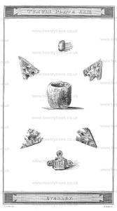
Colt Hoare 1812. [No. 28 [Map]]"In the year 1723, by Thomas Earl of Pembroke's order, I begun upon a barrow north of Stonehenge, in that group south of the Cursus. It is one of the double barrows there, and the more easterly and lower of the two; likewise somewhat less. It was reasonable to believe, thig was the sepulture of and that the lesser was the female; and so it proved; at man and his wife; least a daughter. We made a large cut on the top, from east to west, and after the turf was taken off, we came to the layer of chalk, then to fine garden mould. About three teet below the surface was a layer of flints, humouring the convexity of the barrow. These flints are gathered from the surface of the downs in some places, especially where it has been ploughed. This being about a foot thick, rested on a layer of soft mould another foot, in which was enclosed an urn full of bones. The urn was of unbaked clay, of a dark reddish colour, and crumbled into pieces. It had been rudely wrought with small mould5ngs round the verge, and other circular channels on the outside, with several indentures between, (see Plate XXXII. where have drawn things made with a pointed tool, found in this barrow.) The bones had been burned, and crowded all together in a little heap, not so much as a hat crown would contain. The collar-bone, and one side of the under-jaw, are graved in their true magnitude. It appears have been a girl of about 14 years old, by their bulk, and the great quantity of female ornaments mixed with the bones, all which we gathered. Beads of all sorts, and in great number, of glass of divers colours, most yellow, one black; many single, many in long pieces notched between, so as to resemble a string of beads, and these were generally of a blue colour. There were many of amber, of all shapes and sizes; flat squares, long squares, round, oblong, and great. Likewise many of earth, of different shapes, magnitude, and colour; some little and white, many large and flattish like a button, others like a pully; but all had holes to run a string through, either through their diameter, or sides. Many of the button sort seem to have been covered with metal, there being a rim worked in them, wherein to turn the edge of the covering. One of these was covered with a thin film of pure gold. These were the young lady's ornaments; and alt had undergone the fire, so that what would easily consume, fell to pieces as soon as handled; much of the amber was burned half through. This person was a heroine, for we found the head of her javelin in brass. At bottom me two holes for the pins that fastened it to the staff. Besides, there was a sharp bodkin, round at one end, square at the other, where it went into a handle. I still preserve whatever is permanent of these trinkets; but we recomposed the ashes of the illustrious defunct, and covered them with earth, leaving visible marks at cop, of the barrow having been opened, to dissuade any other from again disturbing them; and this was our practice in all the rest."
Europe, British Isles, South-West England, Wiltshire, Stonehenge Landscape, Stonehenge Barrows, Amesbury Barrows, Amesbury Barrow 29 G44 [Map]
Colt Hoare 1812. [No. 29 [Map]]. "Then we opened the next barrow to it, enclosed ill the same ditch, which we supposed the husband or father of this lady. At fourteen inches deep, the mould being mixed with chalk, we came to the entire skeleton of a man; the skull and all the bones exceedingly rotten, and perished through length of time; though this was a barrow of the latest sort, as we conjecture. The body lay north and south, the head to the north."
Not dissuaded by the external appearances, and convinced by experience that all interments found near the surface were subsequent deposits, Mr. CUNNINGTON, in 1803, explored the second tumulus, by making a section rather to the south of the centre, when at the depth of six feet, he came to the floor of the barrow, which was covered with ashes; and on digging still further to the south, he bund a fine oblong cist, about eighteen inches deep, fifteen-inches wide, and two feet long; and in it a complete interment of burned bones, and with them six beads apparently of horn, four of which were perforated; the other two were circular, and rather flat, but all appeared as though they had been burned. Dr. STUKELEY made the same observation respecting the articles found in the other barrow; but he must have been mistaken as to the amber, for we know that fire would entirely consume it.
Europe, British Isles, South-West England, Wiltshire, Stonehenge Landscape, Stonehenge Barrows, Amesbury Barrows, Amesbury Barrow 30 G45 [Map]
Colt Hoare 1812. No. 30 [Map]. A beautiful bell-shaped barrow, and the largest of this group. It measures in diameter from ditch to ditch one hundred and thirty-one feet, and fifteen feet in elevation. The superior size and beauty of this tumulus particularly excited our curiosity, and raised our expectations of success; but alas! after immense labour in throwing out the earth, to the depth of fifteen feet, we found only a simple interment of burned bones, unaccompanied by any urn, the relicts were piled up in a little heap upon the floor arms, or trinkets; where the body had been burned, and close to a small circular cist or cinerarium, which contained black ashes, intermixed with some small fragments of bone.
Europe, British Isles, South-West England, Wiltshire, Stonehenge Landscape, Stonehenge Barrows, Amesbury Barrows, Amesbury Barrow 31 G46 [Map]
Colt Hoare 1812. No. 31 [Map], a bowl-shaped barrow, one hundred and four Feet in base diameter, and seventy-one and a half in elevation, produced on its floor an interment of burned bones, with a small spear head:
Europe, British Isles, South-West England, Wiltshire, Stonehenge Landscape, Stonehenge Barrows, Amesbury Barrows, Amesbury Barrow 32 G47 [Map]
Colt Hoare 1812. and No. 32 [Map], a fine bell-shaped barrow, contained only a simple interment of burned bones.
Europe, British Isles, South-West England, Wiltshire, Stonehenge Landscape, Stonehenge Barrows, Amesbury Barrows, Amesbury Barrow 33 G48 [Map]
Colt Hoare 1812. No. 33 [Map], is a kind of Druid Barrow, present in an area of seventy-eight feet. diameter, surrounded by a fine vallum without the ditch, but having no elevation, as usual, in the centre. Deprived of this index to the place of interment, we expected much trouble in finding it; but our workmen luckily hit on the very spot; and at the depth of two feet, found a circular cist, containing a deposit of burned bones, together with a great many beads. Some of them were pully beads of glass, two of stone, another of a transparent horn-like substance; but the most were of amber, and much decayed.
Europe, British Isles, South-West England, Wiltshire, Stonehenge Landscape, Stonehenge Barrows, Amesbury Barrows, Amesbury Barrow 34 G49 [Map]
Colt Hoare 1812. No. 34 [Map] has had a prior opening; and in No. 35 [Map] we could not find the interment.
Europe, British Isles, South-West England, Wiltshire, Stonehenge Landscape, Stonehenge Barrows, Amesbury Barrows, Amesbury Barrow 35 G50 [Map]
Colt Hoare 1812. No. 34 [Map] has had a prior opening; and in No. 35 [Map] we could not find the interment.
Europe, British Isles, South-West England, Wiltshire, Stonehenge Landscape, Stonehenge Barrows, Amesbury Barrows, Amesbury Barrow 36 G51 [Map]
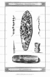
Colt Hoare 1812. No. 36 [Map]. The contents of this barrow, in some degree, recompensed us for our disappointment in the two last. It produced three human skeletons, laid from north to south, and immediately one over the other; the first about two feet deep; the second on a level with the adjoining soil. Close to the right side OF the head of this last skeleton was a drinking cup, and with it a considerable quantity of something that appeared like decayed leather. Six feet lower lay the third, with which was found the drinking cup, engraved in Tumuli Plate XVI. When throwing out the bones of this skeleton, we had a strong proof how well they are preserved when deposited deep in the chalk. as they would bear being thrown for a considerable distancc without breaking: the teeth were perfectly white, and not. one of them unsound; but the most remarkable circumstance was, finding a piece of the skull, about five inches broad, that had been apparently sawn off, for I do not think that any knife could have cut it off in the manner in which this was done.
Europe, British Isles, South-West England, Wiltshire, Stonehenge Landscape, Stonehenge Barrows, Amesbury Barrows, Amesbury Barrow 37 G62 [Map]
Colt Hoare 1812. No. 37 [Map]. In this barrow we found only a large oblong cist, fuli of black ashes, and a few burned human bones; and in No. 38 [Map], after much labour, we missed the interment.
Europe, British Isles, South-West England, Wiltshire, Stonehenge Landscape, Stonehenge Barrows, Amesbury Barrows, Amesbury Barrow 38 G53 [Map]
Colt Hoare 1812. No. 37 [Map]. In this barrow we found only a large oblong cist, fuli of black ashes, and a few burned human bones; and in No. 38 [Map], after much labour, we missed the interment.
Europe, British Isles, South-West England, Wiltshire, Stonehenge Landscape, Stonehenge Barrows, Amesbury Barrows, Amesbury Barrow 39 G54 [Map]
Colt Hoare 1812. No. 39 [Map] is a bowl-shaped tumulus, adjoining the south side. Of the CURSUS: is seventy-eight feet in diameter, and at this time nearly seven feet in elevation, although it has been some wears under tillage. This interesting barrow had experienced a prior, but a partial opening and one skeleton, with a drinking cup, had been disturbed, On reaching the floor, we discovered another skeleton, lying with its head due north, which, from the size of the bones, and the great quantity of beads attending the interment, we conceived to have been that of a female; and several of these being found near the neck, confirmed, in some degree, this opinion. Close to the head stood a kind of bason, neatly ornamented round the verge, but unfortunately broken into several pieces. On removing the head, we were much surprised to find chat it rested upon a drinking cop, that had been placed at the feet of another skeleton, and which was interred ill an oblong cist two deep, and lying also from north to south. With the drinking cup was a spear head of flint, and a singular stone.
In this tumulus, three persons were interred; the primary deposit must, of course, have been the skeleton lying in a cist, excavated within the chalk; the second was probably the wife of this person, lying with her head at his feet; and the third and last, might have been their son. The drinking cup found at the feet of the primary interment, is large, and holds more than a quart; resembles in form and manufacture many of the others; is made out of poor clay, intermixed with bits of chalk; yet it is profusely ornamented, and in a different style to any we have yet seen. How such a multitude of indentations could be put on the surface, while the clay retained its flexibility, is surprising; for it is very clear, that these ornaments were put on singly, and most probably by a bone instrument. The sharpness and nicety to which this spear head of flint, as well as the arrows of the same material, have been chipped, must also strike the attention of every observer. Yet we know them to have been made use of, by all barbarians, for destructive purposes. Neither must the aforementioned stone be passed over unnoticed; it is very neatly polished, feels silky, and, at. first sight, looks something like fossil wood: it is striped irregularly, with dark green and white, and its proportions will be ascertained by the annexed engraving, Plate XVII. which represents both the spear head and stone, of their natural size. Mr. CUNNINGTON thinks it is of that' species of stone called by KIRWAN, ligniformed asbestos, and that it may have been considered by the Britons as of high value, from its supposed virtues.
Europe, British Isles, South-West England, Wiltshire, Stonehenge Landscape, Stonehenge Barrows, Amesbury Barrows, Amesbury Barrow 40 G55 [Map]
Colt Hoare 1812. No. 40 [Map], in point of size, may be called the monarch of the plain, being evidently the largest barrow upon it; and its history still remains veiled in obscurity. The first time we opened it by a very large section, and examined well the floor; but though we perceived symptoms of cremation, in charred wood, &c. we could not discover the primary interment. Nor were our subsequent researches more favourable, and we still remain in ignorance. Perhaps some future antiquary may be more fortunate; and such is the caprice of ancient sepulture, that the deposit may be föand near the top, as in the instance of our flint barrow at Kingston Deveril, (p. 47.)
Europe, British Isles, South-West England, Wiltshire, Stonehenge Landscape, Stonehenge Monuments and Burials, Coneybury Hill Barrow [Map]
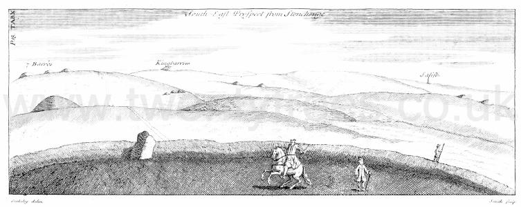
Stonehenge by William Stukeley. Table X. South East Prospect from Stonehenge. [Left to right, north to south, New King Barrows, a barrow named as Kingbarrow but is likely to be Coneybury Hill Barrow [Map], the spire of Salisbury Cathedral [Map]]
Europe, British Isles, South-West England, Wiltshire, Stonehenge Landscape, Stonehenge Barrows, Cursus Barrows, Cursus Barrow 41 G29 [Map]
Colt Hoare 1812. No. 41 [Map] produced an interment of burned bones.
Europe, British Isles, South-West England, Wiltshire, Stonehenge Landscape, Stonehenge Barrows, Cursus Barrows, Cursus Barrow 42 G28 [Map]
Colt Hoare 1812. No. 42 [Map]. Nearly opposite the last mentioned barrow, but on the south side of the turnpike road; is a neat circular tumulus, sixty-six feet in diameter, and six feet in elevation, which was opened in 1803, and produced within a circular cist, an interment of burned bones, and a brass pin with part of its handle, deposited in a neat and perfect urn; the latter of which is engraved in Tumuli Plate XVI.
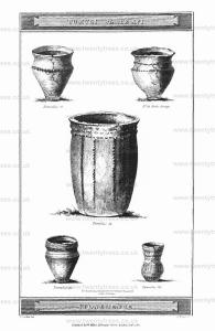
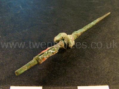
Wiltshire Museum. DZSWS:STHEAD.228. 1 bronze awl with a square tang and fragments of a bone handle attached, found with a primary cremation (female?) inside an Enlarged food vessel urn in bowl barrow Winterbourne Stoke G28 [Map], excavated by William Cunnington.
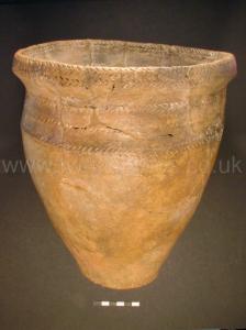
Wiltshire Museum. DZSWS:STHEAD.264. 1 Enlarged Food Vessel with a band of chevrons around the neck, two bands around the outer rim, one band around the inner rim and bands of diagonal lines around the rim, waist and base, found with a primary cremation (female?) inside in bowl barrow Winterbourne Stoke G28 [Map], excavated by William Cunnington.
Europe, British Isles, South-West England, Wiltshire, Stonehenge Landscape, Stonehenge Barrows, Cursus Barrows, Cursus Barrow 43 G56 [Map]
Colt Hoare 1812. No. 43 [Map] and No. 44 [Map], These two barrows are included within the boundaries of the CURSUS, and very near the western end of it. In opening the first of these, our labourers discovered, at the depth of three feet, the skeleton of an adult, with a drinking cup, and on the floor of the barrow, another of a child. We afterwards, in a shallow cist, found the third skeleton of-a man, lying with his head to the north, and close to it, on the right side, was a curious pebble, and under his left hand was a dagger of brass. The pebble is kidney-formed, of the sardonyx kind, striated transversely with alternate spaces, that give it the appearance of belts; besides these stria, it is spotted all over with very small white specks, and after dipping it into water, it assumes a sea green colour.
In the adjoining barrow, No. 44 [Map], we found only a simple interment of burned bones.
Europe, British Isles, South-West England, Wiltshire, Stonehenge Landscape, Stonehenge Barrows, Cursus Barrows, Cursus Barrow 44 G30 [Map]
Colt Hoare 1812. No. 43 [Map] and No. 44 [Map], These two barrows are included within the boundaries of the CURSUS, and very near the western end of it. In opening the first of these, our labourers discovered, at the depth of three feet, the skeleton of an adult, with a drinking cup, and on the floor of the barrow, another of a child. We afterwards, in a shallow cist, found the third skeleton of-a man, lying with his head to the north, and close to it, on the right side, was a curious pebble, and under his left hand was a dagger of brass. The pebble is kidney-formed, of the sardonyx kind, striated transversely with alternate spaces, that give it the appearance of belts; besides these stria, it is spotted all over with very small white specks, and after dipping it into water, it assumes a sea green colour.
In the adjoining barrow, No. 44 [Map], we found only a simple interment of burned bones.
Europe, British Isles, South-West England, Wiltshire, Stonehenge Landscape, Stonehenge Barrows, Cursus Barrows, Cursus Barrow 45 G33 [Map]
Colt Hoare 1812. The next barrows that occur in our Iter westward, are three in number, placed nearly in a line parallel to each other. No. 45 [Map], 46 [Map], 47 [Map], all of which proved uninteresting in their contents. The first and last produced simple interments of burned bones; the second, a rude urn with cremation.
Europe, British Isles, South-West England, Wiltshire, Stonehenge Landscape, Stonehenge Barrows, Cursus Barrows, Cursus Barrow 46 G32 [Map]
Colt Hoare 1812. The next barrows that occur in our Iter westward, are three in number, placed nearly in a line parallel to each other. No. 45 [Map], 46 [Map], 47 [Map], all of which proved uninteresting in their contents. The first and last produced simple interments of burned bones; the second, a rude urn with cremation.
Europe, British Isles, South-West England, Wiltshire, Stonehenge Landscape, Stonehenge Barrows, Cursus Barrows, Cursus Barrow 47 G31 [Map]
Colt Hoare 1812. The next barrows that occur in our Iter westward, are three in number, placed nearly in a line parallel to each other. No. 45 [Map], 46 [Map], 47 [Map], all of which proved uninteresting in their contents. The first and last produced simple interments of burned bones; the second, a rude urn with cremation.
Europe, British Isles, South-West England, Wiltshire, Stonehenge Landscape, Stonehenge Barrows, Cursus Barrows, Cursus Barrow 48 G34 [Map]
Colt Hoare 1812. No, 48 [Map], a Druid barrow, contained an interment of burned bones, with a brass pin.
Europe, British Isles, South-West England, Wiltshire, Stonehenge Landscape, Stonehenge Barrows, Cursus Barrows, Cursus Barrow 49 G35a-c [Map]
Colt Hoare 1812. No. 49 [Map] is a long barrow.
Wiltshire Archaeological Magazine 1868 V11 Pages 40-49. The importance of discoveries, even apparently trivial, which throw light on the relative age of our more primeval antiquities, or which serve to connect one with another objects of this description, will at once be admitted.
The barrow [Cursus Barrow 49 G35a-c [Map]] in which the flint objects now exhibited were discovered is situated on Winterbourne Stoke Down, about 1½ mile north-west of Stonehenge. It is within a few yards of the western end of the low earthwork known as the "smaller cursus," and is numbered 49 on the "Map of Stonehenge, and its Environs," in Sir Richard Hoare's Ancient Wilts (vol. i. p. 170). It was passed over, when the barrows around it were generally excavated, in or about the year 1808; and all that Sir Richard says of it is, "No. 49 is a long barrow" (p. 165); a designation, however, which we shall find is not strictly appropriate, and is very liable to misconception. The form of the barrow is oval, it being about 140 feet in length by 70 in breadth, and in height less than 2 feet above the level of the down. Its long axis lies east and west, and it is surrounded by a slight ditch continued round both ends of the barrow. It is thus seen to differ in several particulars from the Long Barrow properly so-called; in which the interments, belonging apparently to the stone-age, and by simple inhumation, are confined to the broad east end of the barrow. The true long barrow is usually of much greater size, often reaching 250 or 300 feet and upwards in length, and having an elevation of from 5 to 10 feet, or even more. One end, usually that directed to the east, is almost always broader and higher than the other; but the most remarkable distinction is in the trench, which is carried the whole length of the barrow on each side, without being continued around the ends. These peculiarities of the long barrow are well shown in the engraving in "Ancient Wilts," (vol. i. p. 21. "I. Long Barrow") The Oval Barrow No. 49, like others of a similar form and description, belongs no doubt to a different and more recent period than the true long barrows, and to the same age as the circular barrows of the ordinary bowl and bell shapes. Its oval form appears to depend upon its having been designed for two or three distinct interments, placed at tolerably regular intervals.1 This variety of tumulus was not altogether overlooked by Sir Richard Hoare, by whom two or three such were excavated. Of one he gives a representation, as the specimen of his twelfth form of barrow, which he terms "Long barrow No. 2." His words are as follows: — "XII. Long Barrow No. 2. This tumulus in shape resembles a small long barrow, but diflfers from the larger kind, by having a ditch all around it." (p. 22.)
Note 1. For all purposes of argument, oval barrows (as distinguished from long barrows) and round barrows may be regarded as identical. The two are clearly coeval, and the work of the same people. An oval barrow, in my view, is a congeries of two or more round barrows.
Europe, British Isles, South-West England, Wiltshire, Stonehenge Landscape, Stonehenge Barrows, Cursus Barrows, Cursus Barrow 50 G36 [Map]
Colt Hoare 1812. No. 50 [Map] is a circular bowl-shaped barrow, in the examination of which, we experienced much perplexity, although not uncommon, owing the Britons having adopted so many modes of burial. At the depth of five feet, we found a regular stratum af flints, intermixed with black vegetable mould; on removing which, we came to the floor of the barrow, in which some excavations had been made, and channels formed. One of these was connected with the cist, which contained a skeleton lying from south to north; in another channel, we found a large branch of a stag's horn; and in a little corner, we took out a shovel-full of bones, intermixed with earth, which were broken almost as small as chaff. Near the feet of the skeleton lay a considerable quantity of very small bones of birds or mice. The day being far advanced, we did not pursue all the channels, and it is very probable that this barrow may contain other skeletons.
Europe, British Isles, South-West England, Wiltshire, Stonehenge Landscape, Stonehenge Barrows, Cursus Barrows, Cursus Barrow 51 G37 [Map]
Colt Hoare 1812. No. 51 [Map], a fine bell-shaped barrows ninety-five feet in diameter, and seven feet in elevation. At the depth of four feet and a half in the native soil, viz. eleven feet and a half from the summit, we found two skeletons with their heads laid towards the north; the one, an adult, the other, a young person, not more than about twelve years of age.
Europe, British Isles, South-West England, Wiltshire, Stonehenge Landscape, Stonehenge Barrows, Cursus Barrows, Cursus Barrow 52 G38 [Map]
Colt Hoare 1812. No. 52 [Map] and No. 53 [Map]. We were unsuccessful in our attempts on these two large barrows. In the former, we perceived several marks of very intense fire, with some earth, quite black, and some burned to a brick colour. In the latter, near the centre, we found a circular cist containing only ashes, but missed the primary interment. An unusual quantity of small bones, probably of birds, was dispersed about the barrow.
Europe, British Isles, South-West England, Wiltshire, Stonehenge Landscape, Stonehenge Barrows, Cursus Barrows, Cursus Barrow 53 G39 [Map]
Colt Hoare 1812. No. 52 [Map] and No. 53 [Map]. We were unsuccessful in our attempts on these two large barrows. In the former, we perceived several marks of very intense fire, with some earth, quite black, and some burned to a brick colour. In the latter, near the centre, we found a circular cist containing only ashes, but missed the primary interment. An unusual quantity of small bones, probably of birds, was dispersed about the barrow.
Europe, British Isles, South-West England, Wiltshire, Stonehenge Landscape, Stonehenge Barrows, Cursus Barrows, Cursus Barrow 54 G40 [Map]
Colt Hoare 1812. No. 54 [Map]. A fine bell-shaped barrow, eighty feet in diameter, and seven feet in elevation, produced on the floor and near the centre, a circular cist, about eighteen inches wide, and one foot deep, full of wood ashes. and a few fragments of burned bones. About two feet to the north of the above was another cist, of an oblong form, much larger and deeper than the other, which contained an interment af burned bones, piled up ill heap in the centre of the cist.
Europe, British Isles, South-West England, Wiltshire, Stonehenge Landscape, Stonehenge Barrows, Cursus Barrows, Cursus Barrow 55 G41 [Map]
Colt Hoare 1812. The next barrow, No. 55 [Map], was opened some years ago, and produced only a simple interment of burned bones. A little on the other side of the Devizes road is a mound, which being only a land mark, is not numbered.
Europe, British Isles, South-West England, Wiltshire, Stonehenge Landscape, Stonehenge Barrows, Cursus Barrows, Cursus Barrow 56 G42 [Map]
Colt Hoare 1812. In the adjoining large flat barrow, No. 56 [Map], we discovered a cist, that had been previously investigated, but on opening it, the workmen found an arrow head of flint near the top.
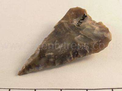
Wiltshire Museum. DZSWS:STHEAD.83. 1 triangular arrowhead without barbs, found in a empty (disturbed) cist in bowl barrow, Winterbourne Stoke G42 [Map], excavated by William Cunnington.
Europe, British Isles, South-West England, Wiltshire, Stonehenge Landscape, Stonehenge Barrows, Cursus Barrows, Cursus Barrow 57 G46 [Map]
Colt Hoare 1812. I shall now direct my steps back towards Amesbury, over a beautiful down, abounding with tumuli of various descriptions, The first, group that occurs, is situated near the northern limits of our map, and is numbered from 57 to 65, and consists of four Druid, and five circular barrows. As they all bore the marks of prior opening, I did not attempt any of them: some had been explored a few years ago, by Mr. CUNNINGTON, at a time when no idea was entertained of prosecuting his researches to the present extent, and when no very regular account was kept of his discoveries.1
Note. No. 57 [Map], No. 58 [Map], No. 59 [Map], No. 60 [Map], No. 61 [Map], No. 62 [Map], No. 63 [Map], NO. 64 [Map], No. 65 [Map].
Colt Hoare 1812. On the opposite hill is a beautiful group of tumuli, thickly strewed over a rich and verdant down. Their perfect appearance raised our expectations of success, and the attendance of many of my friends from Salisbury, and a beautiful day, enlivened our prospects; but we had again sad cause to exclaim Fronti nullaa fides, Trust not to outward appearances. No arrow heads were found to mark the profession of the British hunter; no gilded dagger to point out to us the chieftain of the clan; nor any necklace of amber or jet, to distinguish the British female, or to present to her fair descendants, who honoured us with their presence on this occasion: a few rude urns marked the antiquity and poverty of the Britons who fixed on this spot as their mausoleum, Unproductive, however, as were the contents of these barrows, it may not be uninteresting to the antiquary, whom either chance or curiosity leads across these fine plains, to know their history.
Note 1. On referring to Mr. CUNNINGTON'S papers, find some account of these barrows. The Druid barrows had been partially opened: in one, he found an interment, with a broken dart or lance of brass; and in another, the scattered fragments or burned bones, a Few small amber rings, beads of the same, and of jet, with the point of a brass dart. In opening the large barrow, No. 57 [Map] he found a cist, at the depth twelve feet from the surface, the remainder (as he thought) of the brass dart, and with it a curious whetstone, some ivory tweezers, and some decayed articles of bone.
Europe, British Isles, South-West England, Wiltshire, Stonehenge Landscape, Stonehenge Barrows, Cursus Barrows, Cursus Barrow 58 G49 [Map]
Colt Hoare 1812. I shall now direct my steps back towards Amesbury, over a beautiful down, abounding with tumuli of various descriptions, The first, group that occurs, is situated near the northern limits of our map, and is numbered from 57 to 65, and consists of four Druid, and five circular barrows. As they all bore the marks of prior opening, I did not attempt any of them: some had been explored a few years ago, by Mr. CUNNINGTON, at a time when no idea was entertained of prosecuting his researches to the present extent, and when no very regular account was kept of his discoveries.1
Note. No. 57 [Map], No. 58 [Map], No. 59 [Map], No. 60 [Map], No. 61 [Map], No. 62 [Map], No. 63 [Map], NO. 64 [Map], No. 65 [Map].
Europe, British Isles, South-West England, Wiltshire, Stonehenge Landscape, Stonehenge Barrows, Cursus Barrows, Cursus Barrow 59 G50 [Map]
Colt Hoare 1812. I shall now direct my steps back towards Amesbury, over a beautiful down, abounding with tumuli of various descriptions, The first, group that occurs, is situated near the northern limits of our map, and is numbered from 57 to 65, and consists of four Druid, and five circular barrows. As they all bore the marks of prior opening, I did not attempt any of them: some had been explored a few years ago, by Mr. CUNNINGTON, at a time when no idea was entertained of prosecuting his researches to the present extent, and when no very regular account was kept of his discoveries.1
Note. No. 57 [Map], No. 58 [Map], No. 59 [Map], No. 60 [Map], No. 61 [Map], No. 62 [Map], No. 63 [Map], NO. 64 [Map], No. 65 [Map].
Europe, British Isles, South-West England, Wiltshire, Stonehenge Landscape, Stonehenge Barrows, Cursus Barrows, Cursus Barrow 60 G48 [Map]
Colt Hoare 1812. I shall now direct my steps back towards Amesbury, over a beautiful down, abounding with tumuli of various descriptions, The first, group that occurs, is situated near the northern limits of our map, and is numbered from 57 to 65, and consists of four Druid, and five circular barrows. As they all bore the marks of prior opening, I did not attempt any of them: some had been explored a few years ago, by Mr. CUNNINGTON, at a time when no idea was entertained of prosecuting his researches to the present extent, and when no very regular account was kept of his discoveries.1
Note. No. 57 [Map], No. 58 [Map], No. 59 [Map], No. 60 [Map], No. 61 [Map], No. 62 [Map], No. 63 [Map], NO. 64 [Map], No. 65 [Map].
Europe, British Isles, South-West England, Wiltshire, Stonehenge Landscape, Stonehenge Barrows, Cursus Barrows, Cursus Barrow 61 G47 [Map]
Colt Hoare 1812. I shall now direct my steps back towards Amesbury, over a beautiful down, abounding with tumuli of various descriptions, The first, group that occurs, is situated near the northern limits of our map, and is numbered from 57 to 65, and consists of four Druid, and five circular barrows. As they all bore the marks of prior opening, I did not attempt any of them: some had been explored a few years ago, by Mr. CUNNINGTON, at a time when no idea was entertained of prosecuting his researches to the present extent, and when no very regular account was kept of his discoveries.1
Note. No. 57 [Map], No. 58 [Map], No. 59 [Map], No. 60 [Map], No. 61 [Map], No. 62 [Map], No. 63 [Map], NO. 64 [Map], No. 65 [Map].
Europe, British Isles, South-West England, Wiltshire, Stonehenge Landscape, Stonehenge Barrows, Cursus Barrows, Cursus Barrow 62 G1 [Map]
Colt Hoare 1812. I shall now direct my steps back towards Amesbury, over a beautiful down, abounding with tumuli of various descriptions, The first, group that occurs, is situated near the northern limits of our map, and is numbered from 57 to 65, and consists of four Druid, and five circular barrows. As they all bore the marks of prior opening, I did not attempt any of them: some had been explored a few years ago, by Mr. CUNNINGTON, at a time when no idea was entertained of prosecuting his researches to the present extent, and when no very regular account was kept of his discoveries.1
Note. No. 57 [Map], No. 58 [Map], No. 59 [Map], No. 60 [Map], No. 61 [Map], No. 62 [Map], No. 63 [Map], NO. 64 [Map], No. 65 [Map].
Europe, British Isles, South-West England, Wiltshire, Stonehenge Landscape, Stonehenge Barrows, Cursus Barrows, Cursus Barrow 63 G2 [Map]
Colt Hoare 1812. I shall now direct my steps back towards Amesbury, over a beautiful down, abounding with tumuli of various descriptions, The first, group that occurs, is situated near the northern limits of our map, and is numbered from 57 to 65, and consists of four Druid, and five circular barrows. As they all bore the marks of prior opening, I did not attempt any of them: some had been explored a few years ago, by Mr. CUNNINGTON, at a time when no idea was entertained of prosecuting his researches to the present extent, and when no very regular account was kept of his discoveries.1
Note. No. 57 [Map], No. 58 [Map], No. 59 [Map], No. 60 [Map], No. 61 [Map], No. 62 [Map], No. 63 [Map], NO. 64 [Map], No. 65 [Map].
Europe, British Isles, South-West England, Wiltshire, Stonehenge Landscape, Stonehenge Barrows, Cursus Barrows, Cursus Barrow 64 G3 [Map]
Colt Hoare 1812. I shall now direct my steps back towards Amesbury, over a beautiful down, abounding with tumuli of various descriptions, The first, group that occurs, is situated near the northern limits of our map, and is numbered from 57 to 65, and consists of four Druid, and five circular barrows. As they all bore the marks of prior opening, I did not attempt any of them: some had been explored a few years ago, by Mr. CUNNINGTON, at a time when no idea was entertained of prosecuting his researches to the present extent, and when no very regular account was kept of his discoveries.1
Note. No. 57 [Map], No. 58 [Map], No. 59 [Map], No. 60 [Map], No. 61 [Map], No. 62 [Map], No. 63 [Map], NO. 64 [Map], No. 65 [Map].
Europe, British Isles, South-West England, Wiltshire, Stonehenge Landscape, Stonehenge Barrows, Cursus Barrows, Cursus Barrow 65 G4 [Map]
Colt Hoare 1812. I shall now direct my steps back towards Amesbury, over a beautiful down, abounding with tumuli of various descriptions, The first, group that occurs, is situated near the northern limits of our map, and is numbered from 57 to 65, and consists of four Druid, and five circular barrows. As they all bore the marks of prior opening, I did not attempt any of them: some had been explored a few years ago, by Mr. CUNNINGTON, at a time when no idea was entertained of prosecuting his researches to the present extent, and when no very regular account was kept of his discoveries.1
Note. No. 57 [Map], No. 58 [Map], No. 59 [Map], No. 60 [Map], No. 61 [Map], No. 62 [Map], No. 63 [Map], NO. 64 [Map], No. 65 [Map].
Europe, British Isles, South-West England, Wiltshire, Stonehenge Landscape, Stonehenge Barrows, Cursus Barrows, Cursus Barrow 66 G8 [Map]
Colt Hoare 1812. No. 66 [Map] is a low barrow, in were fragments of a human skull, of large sepulchral urn, and a drinking cup. No. 67 [Map] has a very irregular and mutilated surface: each seem to have had a prior opening.
Europe, British Isles, South-West England, Wiltshire, Stonehenge Landscape, Stonehenge Barrows, Cursus Barrows, Cursus Barrow 67 G9 [Map]
Colt Hoare 1812. No. 66 [Map] is a low barrow, in were fragments of a human skull, of large sepulchral urn, and a drinking cup. No. 67 [Map] has a very irregular and mutilated surface: each seem to have had a prior opening.
Europe, British Isles, South-West England, Wiltshire, Stonehenge Landscape, Stonehenge Barrows, Cursus Barrows, Cursus Barrow 68 G10 [Map]
Colt Hoare 1812. No. 68 [Map] is a pond barrow.
Europe, British Isles, South-West England, Wiltshire, Stonehenge Landscape, Stonehenge Barrows, Durrington Barrows, Durrington Barrow 69 G11 [Map]
Colt Hoare 1812. No. 69 [Map] had been opened in former times by Mr. CUNNINGTON.
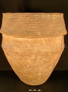
Wiltshire Museum. DZSWS:STHEAD.176. 1 Collared Urn with high shoulders and decorated with 10 cord impressed lines around overhanging collar, found with a primary cremation inside in bowl barrow Durrington G11 [Map], excavated by William Cunnington.
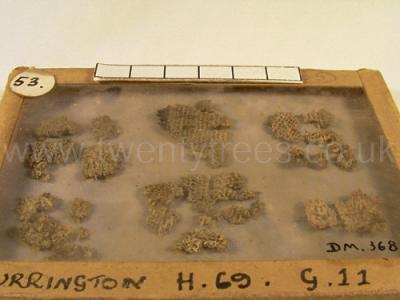
Wiltshire Museum. DZSWS:STHEAD.205. 22 fragments of a coarse linen cloth bag (or casts of cloth formed by lime carbonate) woven with double thread, found wrapping a primary cremation in an MBA collared urn in bowl barrow Durrington G11 [Map], excavated by William Cunnington.
Europe, British Isles, South-West England, Wiltshire, Stonehenge Landscape, Stonehenge Barrows, Durrington Barrows, Durrington Barrow 70 G12 [Map]
Colt Hoare 1812. No. 70 [Map] contained an interment of burned bones, deposited in an irregular cist.
Europe, British Isles, South-West England, Wiltshire, Stonehenge Landscape, Stonehenge Barrows, Durrington Barrows, Durrington Barrow 71 G13 [Map]
Colt Hoare 1812. No. 71 [Map]. A Druid barrow of the second class, or rather bowl-shaped within a ditch, produced the skeleton of a child near the surface, and lower down, two rude sepulchral urns, the one above the other, each containing burned bones.
Europe, British Isles, South-West England, Wiltshire, Stonehenge Landscape, Stonehenge Barrows, Durrington Barrows, Durrington Barrow 72 G19 [Map]
Colt Hoare 1812. No. 72 [Map] had been opened before by Mr. CUNNINGTON, and produced a sepulchral urn.
Europe, British Isles, South-West England, Wiltshire, Stonehenge Landscape, Stonehenge Barrows, Durrington Barrows, Durrington Barrow 73 G14 [Map]
Colt Hoare 1812. No. 73 [Map], a Druid barrow of the second class, contained near the surface, a skeleton with four wooden beads near its neck; and it appeared, that another interment of burned bones had been taken out.
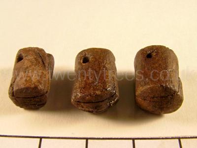
Wiltshire Museum. DZSWS:STHEAD.223. 3 pestle-shaped shale pendants (bored through one side, but not the centre) found near the neck of a secondary (?) inhumation in saucer barrow Durrington G14 [Map], excavated by William Cunnington.
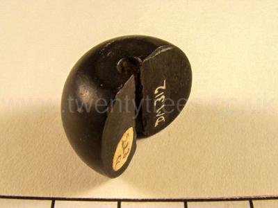
Wiltshire Museum. DZSWS:STHEAD.223a. 1 globular jet bead (split in half) found near the neck of a secondary (?) inhumation in saucer barrow Durrington G14 [Map], excavated by William Cunnington.
Europe, British Isles, South-West England, Wiltshire, Stonehenge Landscape, Stonehenge Barrows, Durrington Barrows, Durrington Barrow 74 G15 [Map]
Colt Hoare 1812. No. 74 [Map] is also a Druid barrow, but the elevated mound was not in the centre of the area. It produced a cinerarium, and ashes in a cist.
Europe, British Isles, South-West England, Wiltshire, Stonehenge Landscape, Stonehenge Barrows, Durrington Barrows, Durrington Barrow 75 G16 [Map]
Europe, British Isles, South-West England, Wiltshire, Stonehenge Landscape, Stonehenge Barrows, Durrington Barrows, Durrington Barrow 76 G17 [Map]
Europe, British Isles, South-West England, Wiltshire, Stonehenge Landscape, Stonehenge Barrows, Durrington Barrows, Durrington Barrow 77 G17a [Map]
Europe, British Isles, South-West England, Wiltshire, Stonehenge Landscape, Stonehenge Barrows, Durrington Barrows, Durrington Barrow 78 G23 [Map]
Europe, British Isles, South-West England, Wiltshire, Stonehenge Landscape, Stonehenge Barrows, Durrington Barrows, Durrington Barrow 79 G22 [Map]
Colt Hoare 1812. No. 79 [Map] had also experienced a prior opening.
Europe, British Isles, South-West England, Wiltshire, Stonehenge Landscape, Stonehenge Barrows, Durrington Barrows, Durrington Barrow 80 G21a [Map]
Colt Hoare 1812. No. 80 [Map] is not sepulchral.
Europe, British Isles, South-West England, Wiltshire, Stonehenge Landscape, Stonehenge Barrows, Durrington Barrows, Durrington Barrow 80a G39 [Map]
Colt Hoare 1812. To the south of No. 80, on the opposite hill, is a Druid barrow [Map] (not inserted in the plan), which produced a large rude urn without an interment.
Europe, British Isles, South-West England, Wiltshire, Stonehenge Landscape, Stonehenge Barrows, Durrington Barrows, Durrington Barrow 81 G21 [Map]
Colt Hoare 1812. In No. 81 [Map] we discovered a large rude urn, containing an interment of burned bones.
Europe, British Isles, South-West England, Wiltshire, Stonehenge Landscape, Stonehenge Barrows, Durrington Barrows, Durrington Barrow 82 G20 [Map]
Colt Hoare 1812. No. 82 [Map] had a cinerarium, and two simple interments of burned bones, just under the surface.
Europe, British Isles, South-West England, Wiltshire, Stonehenge Landscape, Stonehenge Barrows, Durrington Barrows, Durrington Barrow 83 G18 [Map]
Colt Hoare 1812. No. 83 [Map] contained a sepulchral urn, with a small brass pin.
Europe, British Isles, South-West England, Wiltshire, Stonehenge Landscape, Stonehenge Barrows, Durrington Barrows, Durrington Barrow 84 G25 [Map]
Colt Hoare 1812. No. 84 [Map] is the largest barrow in this group, and has been ploughed over. In making our section, we found pieces of stag's horns, pottery, and the remains of a skeleton and drinking cup, and two knives; but the primary interment was a skeleton, with its legs gathered up, and hands placed under its head.
Europe, British Isles, South-West England, Wiltshire, Stonehenge Landscape, Stonehenge Barrows, Durrington Barrows, Durrington Barrow 85 G26 [Map]
Colt Hoare 1812. No. 85 [Map] contained originally an interment of burned bones, within a cist, but had been opened.
Europe, British Isles, South-West England, Wiltshire, Stonehenge Landscape, Stonehenge Barrows, Durrington Barrows, Durrington Barrow 86 G27 [Map]
Colt Hoare 1812. No. 86 [Map] had also experienced the same investigation; it had a circular cist, and a cinerarium.
Europe, British Isles, South-West England, Wiltshire, Stonehenge Landscape, Stonehenge Barrows, Durrington Barrows, Durrington Barrow 88 G29 [Map]
Colt Hoare 1812. No. 88 [Map]. A similar, but finer barrow: produced near the surface, just under the turf, the fragments of a rude urn and burned bones, and lower down, a sepulchral urn reversed over a deposit of burned bones.
Europe, British Isles, South-West England, Wiltshire, Stonehenge Landscape, Stonehenge Barrows, Durrington Barrows, Durrington Barrow 89 G32 [Map]
Colt Hoare 1812. No. 89 [Map] has been in tillage: it contained a skeleton, placed in a long circnlar cist, with its head towards the north,
Europe, British Isles, South-West England, Wiltshire, Stonehenge Landscape, Stonehenge Barrows, Durrington Barrows, Durrington Barrow 90 G33 [Map]
Colt Hoare 1812. No. 90 [Map], in tillage, produced a large urn rudely ornamented, and inverted over a deposit of burned bones,
Europe, British Isles, South-West England, Wiltshire, Stonehenge Landscape, Stonehenge Barrows, Durrington Barrows, Durrington Barrow 91 G34 [Map]
Colt Hoare 1812. No. 91 [Map] contained an interment of burned bones, deposited on the floor of the barrow; and beneath it was a deep cist, containing abundance of ashes and charred wood, intermixed with particles of bone.
Europe, British Isles, South-West England, Wiltshire, Stonehenge Landscape, Stonehenge Barrows, Durrington Barrows, Durrington Barrow 92 G35 [Map]
Colt Hoare 1812. No. 92 [Map]. In digging down to the floor of this barrow, we discovered the remains of a skeleton, with fragments of a funeral urn, burned bones, and some enormous pieces of staff's horns. Within a cist, excavated beneath the floor of the barrow, lay a skeleton with its legs gathered up, and head placed towards the north.
Europe, British Isles, South-West England, Wiltshire, Stonehenge Landscape, Stonehenge Barrows, Durrington Barrows, Durrington Barrow 93 G36 [Map]
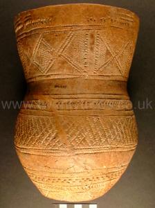
Colt Hoare 1812. No. 93 [Map] contained, near the top, an interment of burned bones, in a rude broken urn, with a small cup; also, the remains of a skeleton, charred wood, stag's horns, and flint apparently prepared for war-like instruments. The primary deposit was a skeleton, with its head placed towards the south-east, accompanied by fine drinking cap, richly ornamented, and in the highest state of preservation, which I have had engraved in Tumuli Plate XVIII. half the size of the original, in order to shew the pattern more conspicuously.
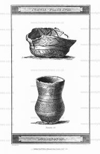
Wiltshire Museum. DZSWS:STHEAD.30. Long Necked Beaker decorated with a band of chevrons bordered by lines around the rim, below the waist and around the base, a band of lozenge shapes around neck and cross-hatching around the body, all using comb and fingernail impressions, found with a primary inhumation in bowl barrow Durrington G36 [Map], excavated by William Cunnington.
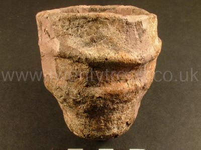
Wiltshire Museum. DZSWS:STHEAD.240. 1 miniature cup with two shoulder ridges, found with an (MBA) collared urn and secondary cremation in bowl barrow Durrington G36 [Map], excavated by William Cunnington.
Europe, British Isles, South-West England, Wiltshire, Stonehenge Landscape, Stonehenge Barrows, Durrington Barrows, Durrington Barrow 94 G37b [Map]
Europe, British Isles, South-West England, Wiltshire, Stonehenge Landscape, Stonehenge Barrows, Durrington Barrows, Durrington Barrow 95 G37a [Map]
Europe, British Isles, South-West England, Wiltshire, Stonehenge Landscape, Stonehenge Barrows, Durrington Barrows, Durrington Barrow 96 G37 [Map]
Europe, British Isles, South-West England, Wiltshire, Stonehenge Landscape, Stonehenge Barrows, Durrington Barrows, Durrington Barrow 97 G66 [Map]
Europe, British Isles, South-West England, Wiltshire, Stonehenge Landscape, Stonehenge Barrows, Durrington Barrows, Durrington Barrow 98 G57 [Map]
Europe, British Isles, South-West England, Wiltshire, Stonehenge Landscape, Stonehenge Barrows, Durrington Barrows, Durrington Barrow 99 G58 [Map]
Europe, British Isles, South-West England, Wiltshire, Stonehenge Landscape, Stonehenge Barrows, Durrington Barrows, Durrington Barrow 100 G51 [Map]
Colt Hoare 1812. No. 100 [Map] contained a simple interment of burned bones within a circular cist.
Europe, British Isles, South-West England, Wiltshire, Stonehenge Landscape, Stonehenge Barrows, Durrington Barrows, Durrington Barrow 101 G47 [Map]
Colt Hoare 1812. No. 101 [Map], a similar interment, accompanied with two black rings of some bituminous substance, and one pully bead.
Europe, British Isles, South-West England, Wiltshire, Stonehenge Landscape, Stonehenge Barrows, Durrington Barrows, Durrington Barrow 102 G48 [Map]
Colt Hoare 1812. No. 102 [Map], an interment of burned bones in a cist, with remnants of the cloth in which the relicts were enveloped.
Europe, British Isles, South-West England, Wiltshire, Stonehenge Landscape, Stonehenge Barrows, Durrington Barrows, Durrington Barrow 103 G49 [Map]
Colt Hoare 1812. No. 103 [Map], a deep circular cist with ashes.
Europe, British Isles, South-West England, Wiltshire, Stonehenge Landscape, Stonehenge Barrows, Durrington Barrows, Durrington Barrow 104 G50 [Map]
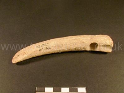
Colt Hoare 1812. No. 104 [Map] is a large flat circular barrow, which had been opened, and must have proved both interesting and productive to those who first investigated it. In the course of our examination, we found the bones of several skeletons, fragments of urns, and a rude instrument made from a stag's horn; there was also a large and deep cist.
Wiltshire Museum. DZSWS:STHEAD.101. 1 perforated antler pick (ground to an edge at the point and perforated for a handle at the larger end) found with a primary or secondary inhumation in bowl barrow Durrington G50 [Map], excavated by William Cunnington.
Europe, British Isles, South-West England, Wiltshire, Stonehenge Landscape, Stonehenge Barrows, Durrington Barrows, Durrington Barrow 105 G52 [Map]
Colt Hoare 1812. No. 105 [Map] and No. 106 [Map] had been opened by others.
Europe, British Isles, South-West England, Wiltshire, Stonehenge Landscape, Stonehenge Barrows, Durrington Barrows, Durrington Barrow 106 G54 [Map]
Colt Hoare 1812. No. 105 [Map] and No. 106 [Map] had been opened by others.
Europe, British Isles, South-West England, Wiltshire, Stonehenge Landscape, Stonehenge Barrows, Durrington Barrows, Durrington Barrow 107 G53 [Map]
Colt Hoare 1812. No. 107 [Map] produced a small interment of burned bones, with a pin of bone at top, and under it, a pile of ashes in a cist.
Europe, British Isles, South-West England, Wiltshire, Stonehenge Landscape, Stonehenge Barrows, Durrington Barrows, Durrington Barrow 108 G51a [Map]
Colt Hoare 1812. No. 108 [Map] is a pond barrow.
Europe, British Isles, South-West England, Wiltshire, Stonehenge Landscape, Stonehenge Barrows, Durrington Barrows, Durrington Barrow 109 G40 [Map]
Colt Hoare 1812. No. 109 [Map], No. 110 [Map], and No. 111 [Map], had been investigated: on opening the first, we found the soil intermixed with the turf, which clearly indicated a prior opening, We were deterred from making any attempt on the second barrow, by a great cavity in its apex; and we found the third had been examined.
Europe, British Isles, South-West England, Wiltshire, Stonehenge Landscape, Stonehenge Barrows, Durrington Barrows, Durrington Barrow 110 G41 [Map]
Colt Hoare 1812. No. 109 [Map], No. 110 [Map], and No. 111 [Map], had been investigated: on opening the first, we found the soil intermixed with the turf, which clearly indicated a prior opening, We were deterred from making any attempt on the second barrow, by a great cavity in its apex; and we found the third had been examined.
Europe, British Isles, South-West England, Wiltshire, Stonehenge Landscape, Stonehenge Barrows, Durrington Barrows, Durrington Barrow 111 G42 [Map]
Colt Hoare 1812. No. 109 [Map], No. 110 [Map], and No. 111 [Map], had been investigated: on opening the first, we found the soil intermixed with the turf, which clearly indicated a prior opening, We were deterred from making any attempt on the second barrow, by a great cavity in its apex; and we found the third had been examined.
Europe, British Isles, South-West England, Wiltshire, Stonehenge Landscape, Stonehenge Barrows, Durrington Barrows, Durrington Barrow 112 G43 [Map]
Colt Hoare 1812. No. 112 [Map] is a double barrow, rising towards the east, and somewhat resembling a long barrow, but ditched all around. The lowest part had been opened, and contained an interment of burned bones. In the other mound, we found an interment of burned bones, secored by a linen cloth under a rude urn.
Europe, British Isles, South-West England, Wiltshire, Stonehenge Landscape, Stonehenge Barrows, Durrington Barrows, Durrington Barrow 113 G44 [Map]
Colt Hoare 1812. No. 113 [Map] had been examined before, but we found in it fragments of an urn and skeleton.
Europe, British Isles, South-West England, Wiltshire, Stonehenge Landscape, Stonehenge Barrows, Durrington Barrows, Durrington Barrow 114 G45 [Map]
Colt Hoare 1812. No. 114 [Map] contained a deposit of burned bones and ashes, in a deep cist.
Europe, British Isles, South-West England, Wiltshire, Stonehenge Landscape, Stonehenge Barrows, Durrington Barrows, Durrington Barrow 116 G62a [Map]
Colt Hoare 1812. No. 116 [Map] had been opened before.
Europe, British Isles, South-West England, Wiltshire, Stonehenge Landscape, Stonehenge Barrows, Durrington Barrows, Durrington Barrow 117 G60 [Map]
Colt Hoare 1812. No. 117 [Map] contained a small rude urn, with an interment of burned bones.
Europe, British Isles, South-West England, Wiltshire, Stonehenge Landscape, Stonehenge Barrows, Durrington Barrows, Durrington Barrow 118 G61 [Map]
Colt Hoare 1812. No. 118 [Map] is a small long barrow, and produced a deposit of burned bones and black ashes in a neat circular cist.
Europe, British Isles, South-West England, Wiltshire, Stonehenge Landscape, Stonehenge Barrows, Durrington Barrows, Durrington Barrow 119 G62 [Map]
Colt Hoare 1812. No. 119 [Map] contained an interment of burned bones in a small cist.
Europe, British Isles, South-West England, Wiltshire, Stonehenge Landscape, Stonehenge Barrows, Durrington Barrows, Durrington Barrow 120 G62b [Map]
Colt Hoare 1812. No. 120 [Map] is a pond barrow; and No. 121 [Map] produced a rude urn reversed over a deposit of burned bones.
Europe, British Isles, South-West England, Wiltshire, Stonehenge Landscape, Stonehenge Barrows, Durrington Barrows, Durrington Barrow 121 G62c [Map]
Colt Hoare 1812. No. 120 [Map] is a pond barrow; and No. 121 [Map] produced a rude urn reversed over a deposit of burned bones.
Europe, British Isles, South-West England, Wiltshire, Stonehenge Landscape, Stonehenge Barrows, Durrington Barrows, Durrington Barrow 122 G65a [Map]
Colt Hoare 1812. On the south side of Durrington Walls, is an elevated mound, bearing the appearance of a barrow, No. 122 [Map], in which we dug to the depth of eleven feet, but found no sepulchral marks whatever.
Europe, British Isles, South-West England, Wiltshire, Stonehenge Landscape, Stonehenge Barrows, Durrington Barrows, Durrington Barrow 123 G65b [Map]
Colt Hoare 1812. A little further on the right of the road leading to Amesbury, we see the mutilated remains of an enormous Druid barrow, No. 123 [Map].
Europe, British Isles, South-West England, Wiltshire, Stonehenge Landscape, Stonehenge Barrows, Durrington Barrows, Durrington Barrow 124 G65c [Map]
Colt Hoare 1812. And still further, on the same side of the road, a very singular tumulus, No. 124 [Map], appearing like three barrows rising from one large base, but certainly a long barrow. It stands from south-west to north-east, and has its wide end towards the west: on the small end, and also on the centre, are mounds resembling two circular barrows. We opened that on the small end, and found only a few ashes and charred wood; but in the central mound we discovered, near the top, a skeleton and a drinking cup, both of which had been disturbed. On reaching the floor of the long barrow, we found a circular cist like a little well, but it contained no interment; from this well-like cist, a tunnel, like a chimney, ascended nearly to the top. I imagine that, as in most of our long barrows, the primary interment would be found at the broad end. In this tumulus we have rather a singular instance of a circular barrow being raised upon a long barrow.
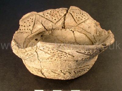
Wiltshire Museum. DZSWS:STHEAD.92. 1 Aldbourne (incense?) cup (distorted by pressure) perforated twice for suspension and decorated with a band of incised zigzags around the flared inner lip and chevrons around the outside of the lip (every other zigzag or chevron of which contained impressed dots) and two bands around the waist - one plain and one with chevrons (below which are a line of dots), found with a primary (?) cremation in bowl barrow Durrington G65c [Map], excavated by William Cunnington.
Europe, British Isles, South-West England, Wiltshire, Stonehenge Landscape, Stonehenge Barrows, Durrington Barrows, Durrington Barrow 125 G38a [Map]
Colt Hoare 1812. No. 125 [Map], in tillage, appears to have been barrow of very large proportions, and there are two others in the corn fields nearer the park, No. 126 [Map], No. 127 [Map], which we have not attempted to open. There are also near them under the hill; same appearances of earthen works much mutilated, which I cannot account for: I once thought they formed part of circle, but I cannot speak with any decision about them.
Europe, British Isles, South-West England, Wiltshire, Stonehenge Landscape, Stonehenge Barrows, Durrington Barrows, Durrington Barrow 126 G39b [Map]
Colt Hoare 1812. No. 125 [Map], in tillage, appears to have been barrow of very large proportions, and there are two others in the corn fields nearer the park, No. 126 [Map], No. 127 [Map], which we have not attempted to open. There are also near them under the hill; same appearances of earthen works much mutilated, which I cannot account for: I once thought they formed part of circle, but I cannot speak with any decision about them.
Europe, British Isles, South-West England, Wiltshire, Stonehenge Landscape, Stonehenge Barrows, Durrington Barrows, Durrington Barrow 127 G39c [Map]
Colt Hoare 1812. No. 125 [Map], in tillage, appears to have been barrow of very large proportions, and there are two others in the corn fields nearer the park, No. 126 [Map], No. 127 [Map], which we have not attempted to open. There are also near them under the hill; same appearances of earthen works much mutilated, which I cannot account for: I once thought they formed part of circle, but I cannot speak with any decision about them.